Ontologies and Spatial Decision Support
|
|
|
- Austen Randall
- 6 years ago
- Views:
Transcription
1 Ontologies and Spatial Decision Support Naicong Li, Philip Murphy, The Redlands Institute, University of Redlands Krzysztof Janowicz, University of California, Santa Barbara Earth Science-Ontolog mini series, Session 2 September 6, 2012

2 Earth sciences and decision making Down stream application for earth science data and models informing decsion making Data and models will have added value when easily discovered and accessed as useful resources for informing large-scale planning and decision making. Need for decision level semantics Peter Fox, Earth science-ontolog mini series,


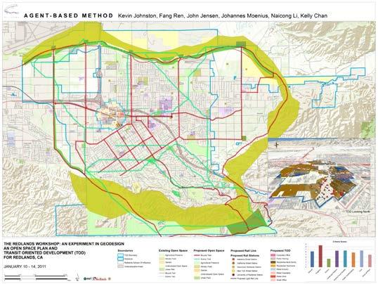
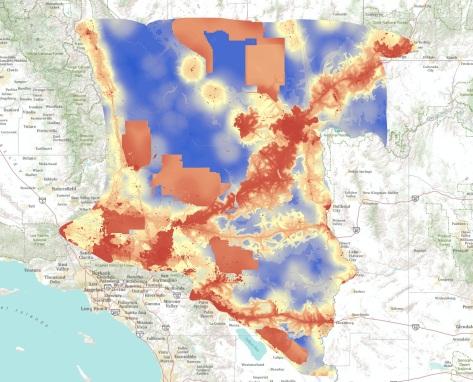


3 Large-scale planning and decision problems 3 3
4 Large-scale planning and decision problems Characteristics of large scale planning and spatial decision problems Complex Involving spatial and temporal dimensions Computationally demanding Inherently cross domain Involving interaction between natural and human systems Finding spatial decision support (SDS) resources often faces Big Data problem Where are the good datasets, tools and models Which ones are most appropriate for the problem at hand Interoperability problem among SDS resources 4
5 Need for formalizing the knowledge in SDS Registration, automatic discovery and access of SDS resources (e.g. workflow templates, methods and algorithms, models and tools, data, cases studies) Encourage modular, reusable models and tools development Facilitate interoperability among models and tools Automatic workflow composition and orchestration Provide a common vocabulary for the user community Facilitate learning in SDS 5

6 One solution SDS ontology and the SDS Knowledge Portal driven by the SDS ontology 6


7 The SDS Consortium Missouri University of Science and Technology 7
8 Content of the SDS ontology Planning/decision problem types Planning process workflows and steps Strategies, methods and techniques that are commonly associated with different workflow steps Models and tools supporting spatial planning Data sources supporting spatial planning Spatial planning/decision support case studies Related concepts supporting the descriptions of the above 8


9 Spatial planning and decision problem types 9


10 Spatial planning workflows 10

11 Steps in a spatial planning workflow 11
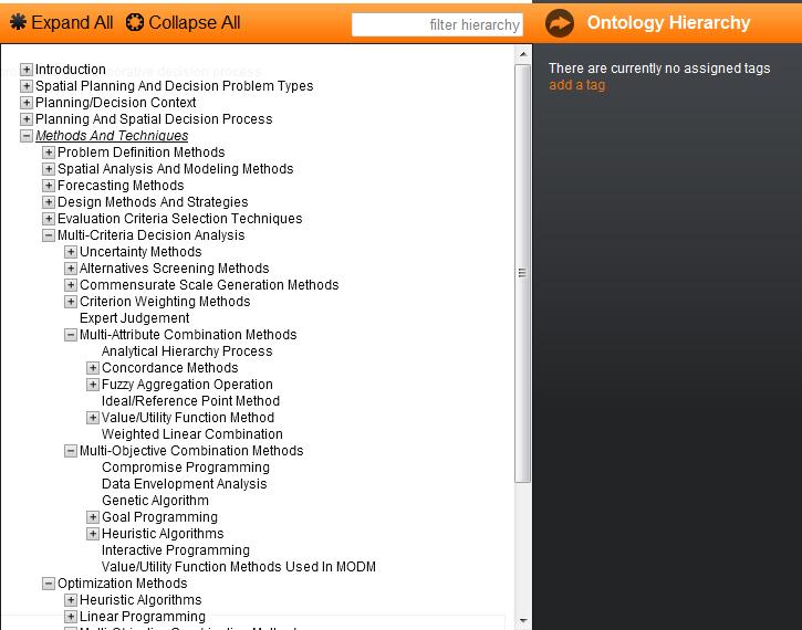
12 Methods, techniques, algorithms 12


13 Software models, tools, services 13

14 Case studies 14

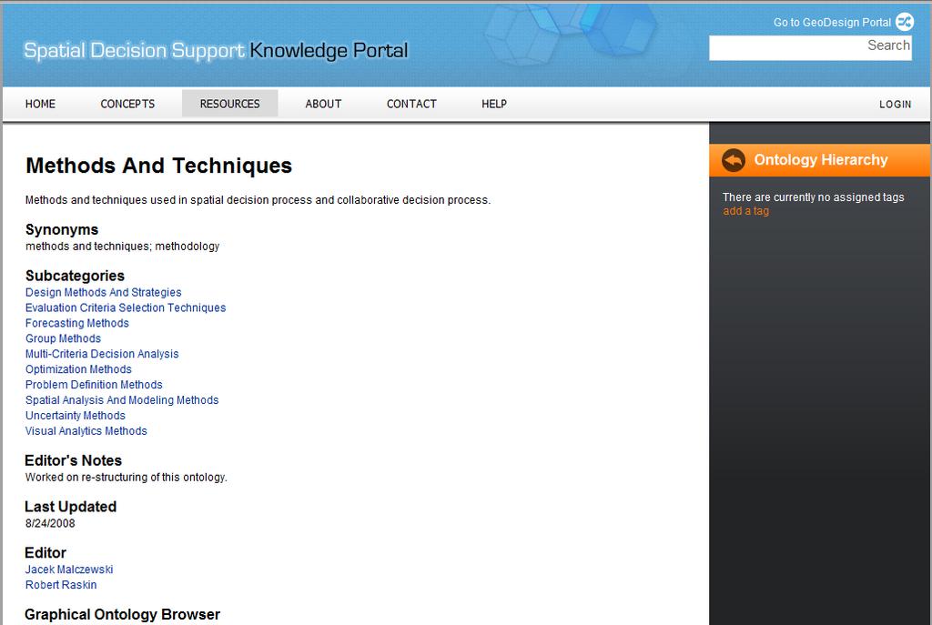
15 Example subgraph of SDS ontology structured planning process workflow, alternative ranking step, weighted summation algorithm, EMDS SDS application, a case study, a decision problem type 15

16 Browsing on SDS Knowledge Portal Follow the relation links from concept to concept Follow the ontology hierarchy Graphical browsing 16


17 Searching on SDS Knowledge Portal Search by filtering Search the ontology hierarchy Advanced emantic search 17
18 From Ontologies (directly) to Computational Workflows Ontologies are not just for conceptual clarity (though we love that!) and for organizing things Decision support researchers and practitioners need them to create interoperable computational applications that deliver decision support for solving Grand Challenge planning and decision problems. 18
19 A planning process workflow 1. How should the system be described? 2. How does the system operate? Steinitz s framework for planning workflow 3. Is the current ecosystem working well? 4. How might the system be altered? 5. What predictable differences might the changes cause? 6. How should the system be changed? 19
20 Earth sciences data and modes in planning workflow 1. How should the system be described? 2. How does the system operate? Steinitz s framework for planning workflow 3. Is the current ecosystem working well? 4. How might the system be altered? 5. What predictable differences might the changes cause? Earth science data, process models, assessment models 6. How should the system be changed? 20
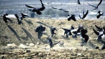
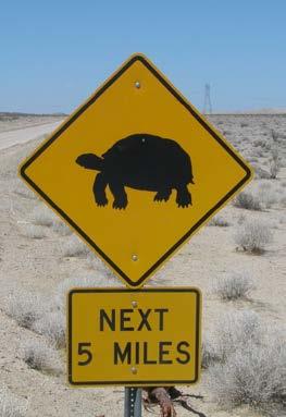
21 Example of Earth Science models -- Process model used in Desert Tortoise Recovery (DTRO) SDS, driving tortoise population change assessment calculation The Fish and Wildlife Service (FWS) DTRO office identified: Which Recovery Actions can be introduced to abate the threat The threats caused by each threat The stresses caused by each threat Which factors each stress causes to overall population change 21


22 Example of Earth Science models -- Process model used in Desert Tortoise Recovery SDS The FWS DTRO created this process model by creating Threat tiles Which Recovery Actions A can threat be introduced description to abate the threat based on the Threat design pattern The threats caused by each threat The 8 stresses 3 caused by each threat Which factors each stress causes to overall population change 22


23 Example of Earth Science models -- Non-native invasive species habitat suitability assessment model (Army Corp of Engineers) Weed traits table: Johnson grass habitat preferences Elevation Sun exposure full Moisture high Soil sandy loam Slope <= 20 percent Surface disturbance promoted elevation suitability surface fuzzy membership elevation surface annual rainfall habitat suitability surface multiply sun exposure suitability surface moisture suitability surface fuzzy membership fuzzy membership sun exposure condition surface moisture condition surface multiply soil water retention levels upland contribution surface soil suitability surface Mapping soil condition surface impervious surface slope suitability surface fuzzy membership slope areas adjacent to water features disturbance surface 23

24 Example of decision models -- Non-native invasive species management on military installations 24


25 Earth science ontologies and SDS ontology The SDS ontology needs to reference the concepts and parameters defined in the Earth science ontologies to Identify the right datasets and models that are appropriate for a specfic decision problem Interoperable 25
26 Earth science ontologies and SDS ontology The SDS ontology currently refers to ISO for data topic concepts (not granular enough) Decision problem types Data models ISO Data attributes Decision contexts Models and tools Decision related Decision process steps Data sources Application domains Decision process workflows Case studies Knowledge domains Decision methods and techniques Literature Software system functionality Participation and collaboration People General Organizations Related websites Editorial information 26
27 Earth science ontologies and SDS ontology The models sub ontology in SDS ontology only refers to knowledge domains taxonomy, but not specific concepts within Earth science domains need to connect to earth science ontologies Decision problem types Data models Data topics Data attributes Decision contexts Models and tools Decision related Decision process steps Data sources Application domains Decision process workflows Case studies Knowledge domains Decision methods and techniques Literature Software system functionality Participation and collaboration People General Organizations Related websites Editorial information 27
28 Workflow composition guided by SDS ontology and Earth science ontologies Grand Changes User s planning problem parameters providing semantic constraints for lower level workflow template selection in terms of Problem type, number of objectives Spatial and temporal analysis unit and extent Application domain, knowledge domain, concepts and parameters in the knowledge domain Semantic constraints for process model selection and data selection Planning workflow Decision model Assessment models Process models Hydrological models Habitat suitability models Geoprocessing, and other computational workflows Implementation platform Cyberinfrastructure 28
29 Contact Naicong Li, Philip Murphy, Krzysztof Janowicz, See also: Li, N., Raskin, R., Goodchild, M. and Janowicz K. (2012) An Ontology-Driven Framework and Web Portal for Spatial Decision Support. Transactions in GIS 16(3):
Ontology Summit 2016: SI Track: SI in the GeoScience Session 1: How is SI Viewed in the GeoSciences"
 Ontology Summit 2016: SI Track: SI in the GeoScience Session 1: How is SI Viewed in the GeoSciences" February 25, 2016 Some Introductory Comments on the Track Topic Gary Berg-Cross Ontolog, RDA US Advisory
Ontology Summit Framing the Conversation: Ontologies within Semantic Interoperability Ecosystems
 Ontology Summit 2016 Framing the Conversation: Ontologies within Semantic Interoperability Ecosystems GeoSciences Track: Semantic Interoperability in the GeoSciences Gary Berg-Cross and Ken Baclawski Co-Champions
Reducing Consumer Uncertainty
 Spatial Analytics Reducing Consumer Uncertainty Eliciting User and Producer Views on Geospatial Data Quality Introduction Cooperative Research Centre for Spatial Information (CRCSI) in Australia Communicate
Surveying, Mapping and Remote Sensing (LIESMARS), Wuhan University, China
, Wuhan University, China") Name: Peng Yue Title: Professor and Director, Institute of Geospatial Information and Location Based Services (IGILBS) Associate Chair, Department of Geographic Information Engineering School of Remote
Name: Peng Yue Title: Professor and Director, Institute of Geospatial Information and Location Based Services (IGILBS) Associate Chair, Department of Geographic Information Engineering School of Remote
Spatial Analysis in CyberGIS
 Spatial Analysis in CyberGIS towards a spatial econometrics workbench Luc Anselin, Sergio Rey and Myunghwa Hwang GeoDa Center School of Geographical Sciences and Urban Planning Arizona State University
Portal for ArcGIS: An Introduction. Catherine Hynes and Derek Law
 Portal for ArcGIS: An Introduction Catherine Hynes and Derek Law Agenda Web GIS pattern Product overview Installation and deployment Configuration options Security options and groups Portal for ArcGIS
From Research Objects to Research Networks: Combining Spatial and Semantic Search
 From Research Objects to Research Networks: Combining Spatial and Semantic Search Sara Lafia 1 and Lisa Staehli 2 1 Department of Geography, UCSB, Santa Barbara, CA, USA 2 Institute of Cartography and
OFWIM 2017 Annual Conference What Does Web GIS Really Mean for Fish and Wildlife Agencies?
 Content Open Mapping OFWIM 2017 Annual Conference What Does Web GIS Really Mean for Fish and Wildlife Agencies? Imagery Spatial Analysis Mike Bialousz, Esri 3D Data Exploration Real-Time Apps Visualization
Leveraging Web GIS: An Introduction to the ArcGIS portal
 Leveraging Web GIS: An Introduction to the ArcGIS portal Derek Law Product Management DLaw@esri.com Agenda Web GIS pattern Product overview Installation and deployment Configuration options Security options
Introduction to Portal for ArcGIS
 Introduction to Portal for ArcGIS Derek Law Product Management March 10 th, 2015 Esri Developer Summit 2015 Agenda Web GIS pattern Product overview Installation and deployment Security and groups Configuration
Innovation. The Push and Pull at ESRI. September Kevin Daugherty Cadastral/Land Records Industry Solutions Manager
 Innovation The Push and Pull at ESRI September 2004 Kevin Daugherty Cadastral/Land Records Industry Solutions Manager The Push and The Pull The Push is the information technology that drives research and
DP Project Development Pvt. Ltd.
 Dear Sir/Madam, Greetings!!! Thanks for contacting DP Project Development for your training requirement. DP Project Development is leading professional training provider in GIS technologies and GIS application
GIS Building Communities beyond National Borders (Building Successful Spatial Data Infrastructures) Nick Land, ESRI Europe
 Nick Land, ESRI Europe") GIS Building Communities beyond National Borders (Building Successful Spatial Data Infrastructures) Nick Land, ESRI Europe UK worst flooding in the last 60 years 350,000 households without drinking water
GIS Building Communities beyond National Borders (Building Successful Spatial Data Infrastructures) Nick Land, ESRI Europe UK worst flooding in the last 60 years 350,000 households without drinking water
ArcGIS Enterprise: What s New. Philip Heede Shannon Kalisky Melanie Summers Sam Williamson
 ArcGIS Enterprise: What s New Philip Heede Shannon Kalisky Melanie Summers Sam Williamson ArcGIS Enterprise is the new name for ArcGIS for Server What is ArcGIS Enterprise ArcGIS Enterprise is powerful
Geospatial Semantics. Yingjie Hu. Geospatial Semantics
 Outline What is geospatial? Why do we need it? Existing researches. Conclusions. What is geospatial? Semantics The meaning of expressions Syntax How you express the meaning E.g. I love GIS What is geospatial?
Introduction to Portal for ArcGIS. Hao LEE November 12, 2015
 Introduction to Portal for ArcGIS Hao LEE November 12, 2015 Agenda Web GIS pattern Product overview Installation and deployment Security and groups Configuration options Portal for ArcGIS + ArcGIS for
Demystifying ArcGIS Online. Karen Lizcano Esri
 Demystifying ArcGIS Online Karen Lizcano Esri An Integrated Web GIS Platform Desktop Web Device Powered by Services Managed via Portal Access from any Device Portal Server Online Content and Services ArcGIS
Web GIS: Architectural Patterns and Practices. Shannon Kalisky Philip Heede
 Web GIS: Architectural Patterns and Practices Shannon Kalisky Philip Heede Web GIS Transformation of the ArcGIS Platform Desktop Apps Server GIS Web Maps Web Scenes Layers Web GIS Transformation of the
The Polar Data Landscape
 The Polar Data Landscape Polar Data Activities, Models and Issues from Local to Global Peter L. Pulsifer, NSIDC, GCRC Carleton University Cameron Wilson, Natural Resources Canada (NRCan) Martha Paiz, Natural
ArcGIS Enterprise: Administration Workflows STUDENT EDITION
 ArcGIS Enterprise: Administration Workflows STUDENT EDITION Copyright 2019 Esri All rights reserved. Course version 1.1. Version release date April 2019. Printed in the United States of America. The information
Data Aggregation with InfraWorks and ArcGIS for Visualization, Analysis, and Planning
 Data Aggregation with InfraWorks and ArcGIS for Visualization, Analysis, and Planning Stephen Brockwell President, Brockwell IT Consulting, Inc. Join the conversation #AU2017 KEYWORD Class Summary Silos
Using OGC standards to improve the common
 Using OGC standards to improve the common operational picture Abstract A "Common Operational Picture", or a, is a single identical display of relevant operational information shared by many users. The
SPATIAL INFORMATION GRID AND ITS APPLICATION IN GEOLOGICAL SURVEY
 SPATIAL INFORMATION GRID AND ITS APPLICATION IN GEOLOGICAL SURVEY K. T. He a, b, Y. Tang a, W. X. Yu a a School of Electronic Science and Engineering, National University of Defense Technology, Changsha,
FOOD WEB. WHY IS THE SUN AT THE BOTTOM? IS THE ALLIGATOR THE LAST LIVING BEING IN THE WEB?
 FOOD WEB http://trinityeverglades.weebly.com WHY IS THE SUN AT THE BOTTOM? IS THE ALLIGATOR THE LAST LIVING BEING IN THE WEB? www.emaze.com FOOD CHAINS (SIMPLER AND LINEAR) AIR (N 2, O 2, CO 2 ) FUNGI
DEKDIV: A Linked-Data-Driven Web Portal for Learning Analytics Data Enrichment, Interactive Visualization, and Knowledge Discovery
 DEKDIV: A Linked-Data-Driven Web Portal for Learning Analytics Data Enrichment, Interactive Visualization, and Knowledge Discovery Yingjie Hu, Grant McKenzie, Jiue-An Yang, Song Gao, Amin Abdalla, and
Spatial Data on the Web Working Group. Geospatial RDA P9 Barcelona, 5 April 2017
 Spatial Data on the Web Working Group Geospatial IG @ RDA P9 Barcelona, 5 April 2017 Spatial Data on the Web Joint effort of the World Wide Web Consortium (W3C) and the Open Geospatial Consortium (OGC)
Lesson 16: Technology Trends and Research
 http://www.esri.com/library/whitepapers/pdfs/integrated-geoenabled-soa.pdf GEOG DL582 : GIS Data Management Lesson 16: Technology Trends and Research Overview Learning Objective Questions: 1. Why is integration
INSPIREd solutions for Air Quality problems Alexander Kotsev
 INSPIREd solutions for Air Quality problems Alexander Kotsev www.jrc.ec.europa.eu Serving society Stimulating innovation Supporting legislation The European data puzzle The European data puzzle 24 official
ArcGIS Enterprise: What s New. Philip Heede Shannon Kalisky Melanie Summers Shreyas Shinde
 ArcGIS Enterprise: What s New Philip Heede Shannon Kalisky Melanie Summers Shreyas Shinde ArcGIS Enterprise is the new name for ArcGIS for Server ArcGIS Enterprise Software Components ArcGIS Server Portal
Spatial Data Infrastructure Concepts and Components. Douglas Nebert U.S. Federal Geographic Data Committee Secretariat
 Spatial Data Infrastructure Concepts and Components Douglas Nebert U.S. Federal Geographic Data Committee Secretariat August 2009 What is a Spatial Data Infrastructure (SDI)? The SDI provides a basis for
4CitySemantics. GIS-Semantic Tool for Urban Intervention Areas
 4CitySemantics GIS-Semantic Tool for Urban Intervention Areas Nuno MONTENEGRO 1 ; Jorge GOMES 2 ; Paulo URBANO 2 José P. DUARTE 1 1 Faculdade de Arquitectura da Universidade Técnica de Lisboa, Rua Sá Nogueira,
Portal for ArcGIS: An Introduction
 Portal for ArcGIS: An Introduction Derek Law Esri Product Management Esri UC 2014 Technical Workshop Agenda Web GIS pattern Product overview Installation and deployment Security and groups Configuration
CyberGIS: What Still Needs to Be Done? Michael F. Goodchild University of California Santa Barbara
 CyberGIS: What Still Needs to Be Done? Michael F. Goodchild University of California Santa Barbara Progress to date Interoperable location referencing coordinate transformations geocoding addresses point-of-interest
Discovery and Access of Geospatial Resources using the Geoportal Extension. Marten Hogeweg Geoportal Extension Product Manager
 Discovery and Access of Geospatial Resources using the Geoportal Extension Marten Hogeweg Geoportal Extension Product Manager DISCOVERY AND ACCESS USING THE GEOPORTAL EXTENSION Geospatial Data Is Very
EXPECTATIONS OF TURKISH ENVIRONMENTAL SECTOR FROM INSPIRE
 EXPECTATIONS OF TURKISH ENVIRONMENTAL SECTOR FROM INSPIRE June, 2010 Ahmet ÇİVİ Tuncay DEMİR INSPIRE in the Eyes of MoEF Handling of Geodata by MoEF Benefits Expected TEIEN First Steps for INSPIRE Final
NREL, Intro to GIS for Wind Energy Siting for IGERT Wind NSF
 NREL, 2010 Intro to GIS for Wind Energy Siting for IGERT Wind NSF Challenge: How to encourage offshore wind in the US while managing ecological responsibility and ocean use conflicts? Introduction NREL,
Key Points Sharing fosters participation and collaboration Metadata has a big role in sharing Sharing is not always easy
 Sharing Resources Geoff Mortson esri, Inc. SDI Solutions Team Key Points Sharing fosters participation and collaboration Metadata has a big role in sharing Sharing is not always easy Data Sharing is Good
From the Venice Lagoon Atlas towards a collaborative federated system
 From the Venice Lagoon Atlas towards a collaborative federated system City of Venice Alessandro Mulazzani CORILA Consortium for Coordination of Research Activities Concerning the Venice Lagoon System ISMAR-CNR
Experiences and Directions in National Portals"
 FIG Seminar on e-land Administration Innsbruck/Austria 2-4 June 2004 "ESRI's Experiences and Directions in National Portals" Kevin Daugherty Cadastral/Land Records Manager ESRI Topic Points Technology
Spatializing Research Hypotheses a long- term research vision for
 Spatializing Research Hypotheses a long- term research vision for spatial@ucsb Werner Kuhn Center for Spatial Studies a vision for spatial Spatial computing shall reach the same level of general utility
Using Big Interagency Databases to Identify Climate Refugia for Idaho s Species of Concern
 Using Big Interagency Databases to Identify Climate Refugia for Idaho s Species of Concern What is a Climate Refugia? habitat that supports a locally reproducing population [or key life history stage]
US National Spatial Data Infrastructure A Spatial Framework for Governance and Policy Development to Enable a Location-Based Digital Ecosystem
 GeoPlatform Workshop 7 Dec 2016, Department of the Interior Washington, D.C. US National Spatial Infrastructure A Spatial Framework for Governance and Policy Development to Enable a Location-Based Digital
Economic and Social Council 2 July 2015
 ADVANCE UNEDITED VERSION UNITED NATIONS E/C.20/2015/11/Add.1 Economic and Social Council 2 July 2015 Committee of Experts on Global Geospatial Information Management Fifth session New York, 5-7 August
What Would John Snow Do (Today)? Part 1
? Part 1") What Would John Snow Do (Today)? Part 1 Tanya Bigos and Derek Law @Tanyabigos @GIS_Bandit Thurs Oct 19 th, 2017 Outline Overview of the ArcGIS Platform Whiteboard discussion Summary Questions A Whole New
What Would John Snow Do (Today)? Part 1 Tanya Bigos and Derek Law @Tanyabigos @GIS_Bandit Thurs Oct 19 th, 2017 Outline Overview of the ArcGIS Platform Whiteboard discussion Summary Questions A Whole New
Implementing the Sustainable Development Goals: The Role of Geospatial Technology and Innovation
 Fifth High Level Forum on UN Global Geospatial Information Management Implementing the Sustainable Development Goals: The Role of Geospatial Technology and Innovation 28-30 November 2017 Sheraton Maria
Appendix D. Model Setup, Calibration, and Validation
 . Model Setup, Calibration, and Validation Lower Grand River Watershed TMDL January 1 1. Model Selection and Setup The Loading Simulation Program in C++ (LSPC) was selected to address the modeling needs
Spatial data interoperability and INSPIRE compliance the platform approach BAGIS
 Spatial data interoperability and INSPIRE compliance the platform approach BAGIS BAGIS Voluntary, independent, public, non-profit organization; Organization with main mission to promote the growth of the
RESEARCG ON THE MDA-BASED GIS INTEROPERABILITY Qi,LI *, Lingling,GUO *, Yuqi,BAI **
 RESEARCG ON THE MDA-BASED GIS INTEROPERABILITY Qi,LI *, Lingling,GUO *, Yuqi,BAI ** * Digital Earth Studio, Peking University, Beijing, 100871 liqi@pku.edu.cn, guolingling@cybergis.org.cn ** Network Department,
XXIII CONGRESS OF ISPRS RESOLUTIONS
 XXIII CONGRESS OF ISPRS RESOLUTIONS General Resolutions Resolution 0: Thanks to the Czech Society commends: To congratulate The Czech Society, its president and the Congress Director Lena Halounová, the
Landscape Planning and Habitat Metrics
 Landscape Planning and Habitat Metrics Frank W. Davis National Center for Ecological Analysis and Synthesis UC Santa Barbara (Tools for Landscape Biodiversity Planning) Jimmy Kagan Institute for Natural
National Fish Habitat Action Plan Data Viewer Application
 Jeff Smith Andrea Ostroff USGS NBII National Fish Habitat Action Plan Data Viewer Application Outline Overview of the NFHAP habitat assessment project. The NFHAP spatial framework. The habitat assessment
Charter for the. Information Transfer and Services Architecture Focus Group
 for the Information Transfer and Services Architecture Focus Group 1. PURPOSE 1.1. The purpose of this charter is to establish the Information Transfer and Services Architecture Focus Group (ITSAFG) as
Taxonomies of Building Objects towards Topographic and Thematic Geo-Ontologies
 Taxonomies of Building Objects towards Topographic and Thematic Geo-Ontologies Melih Basaraner Division of Cartography, Department of Geomatic Engineering, Yildiz Technical University (YTU), Istanbul Turkey
GIS for Crime Analysis. Building Better Analysis Capabilities with the ArcGIS Platform
 GIS for Crime Analysis Building Better Analysis Capabilities with the ArcGIS Platform Crime Analysis The Current State One of the foundations of criminological theory is that three things are needed for
Creating Basemaps to Manage Buildings and Facilities
 Esri International User Conference San Diego, California Technical Workshops July 26, 2012 Creating Basemaps to Manage Buildings and Facilities Mark Stewart and Tamara Yoder Topics for this Session Overview
Education Toolkits for the 21 rst Century Ecological Research
 Education Toolkits for the 21 rst Century Ecological Research NEON s University Education / Outreach Program Leah A. Wasser, Sr. Science Educator, Remote Sensing Ecologist Wendy Gram, Liz Goehring National
Roadmap to interoperability of geoinformation
 Roadmap to interoperability of geoinformation and services in Europe Paul Smits, Alessandro Annoni European Commission Joint Research Centre Institute for Environment and Sustainability paul.smits@jrc.it
Visualizing Uncertainty In Environmental Work-flows And Sensor Streams
 Visualizing Uncertainty In Environmental Work-flows And Sensor Streams Karthikeyan Bollu Ganesh and Patrick Maué Institute for Geoinformatics (IFGI), University of Muenster, D-48151 Muenster, Germany {karthikeyan,pajoma}@uni-muenster.de
Leveraging ArcGIS Online Elevation and Hydrology Services. Steve Kopp, Jian Lange
 Leveraging ArcGIS Online Elevation and Hydrology Services Steve Kopp, Jian Lange Topics An overview of ArcGIS Online Elevation Analysis Using Elevation Analysis Services in ArcGIS for Desktop Using Elevation
The Time is Right to Commit to Use International Standards. Empowering Australia with Spatial Information
 The Time is Right to Commit to Use International Standards Empowering Australia with Spatial Information OUTLINE Energy Industry Metadata Standards Initiative ISO 19115 Revision Australian initiatives
The Geo Web: Enabling GIS on the Internet IT4GIS Keith T. Weber, GISP GIS Director ISU GIS Training and Research Center.
 The Geo Web: Enabling GIS on the Internet IT4GIS Keith T. Weber, GISP GIS Director ISU GIS Training and Research Center In the Beginning GIS was independent The GIS analyst or manager was typically a oneperson
An Overview of Solving Spatial Problems Using ArcGIS
 Esri International User Conference San Diego, CA Technical Workshops An Overview of Solving Spatial Problems Using ArcGIS Linda Beale, Jian Lange July 12 th, 2011 Real World Example Using Spatial Analysis
CHAPTER 22 GEOGRAPHIC INFORMATION SYSTEMS
 CHAPTER 22 GEOGRAPHIC INFORMATION SYSTEMS PURPOSE: This chapter establishes the administration and use of to improve the quality and accessibility of Department s spatial information and support graphical
The CUAHSI Hydrologic Information System
 The CUAHSI Hydrologic Information System Presented by Dr. Tim Whiteaker The University of Texas at Austin 18 November, 2010 Session T1B About the Speaker PhD 2004 Research Associate What You Will Learn
Better Topographic Map Production Using ArcGIS. A Comprehensive Solution for Mapping Organizations
 Better Topographic Map Production Using ArcGIS A Comprehensive Solution for Mapping Organizations The World Is Always Changing As a member of a national mapping organization, you know this is true. You
Pushing the Standards Edge: Collaborative Testbeds to Accelerate Standards Development and Implementation
 Pushing the Standards Edge: Collaborative Testbeds to Accelerate Standards Development and Implementation Mark E. Reichardt President mreichardt@opengeospatial.org 31 October 2006 2006 Open Geospatial
Spatial Data Availability Energizes Florida s Citizens
 NASCIO 2016 Recognition Awards Nomination Spatial Data Availability Energizes Florida s Citizens State of Florida Agency for State Technology & Department of Environmental Protection Category: ICT Innovations
Enabling Geospatial Killer Apps Interfaces, Visualizations and APIs Imaging the World
 International Open Government Data Conference Enabling Geospatial Killer Apps Interfaces, Visualizations and APIs Imaging the World Jim Barrett, Data.gov Geospatial Architect Pat Cummens, Government Strategist,
Investigating the practical relationship between GIS and BIM; then relating that to a 3D cadastre. J. Gabriel van Wyk, Johan Nel
 Investigating the practical relationship between GIS and BIM; then relating that to a 3D cadastre. J. Gabriel van Wyk, Johan Nel Overview So exactly what is BIM? Available BIM offerings in the market Traditional
8 th Arctic Regional Hydrographic Commission Meeting September 2018, Longyearbyen, Svalbard Norway
 8 th Arctic Regional Hydrographic Commission Meeting 11-13 September 2018, Longyearbyen, Svalbard Norway Status Report of the Arctic Regional Marine Spatial Data Infrastructures Working Group (ARMSDIWG)
Introduction to ArcGIS Maps for Office. Greg Ponto Scott Ball
 Introduction to ArcGIS Maps for Office Greg Ponto Scott Ball Agenda What is Maps for Office? Platform overview What are Apps for the Office? ArcGIS Maps for Office features - Visualization - Geoenrichment
TRAITS to put you on the map
 TRAITS to put you on the map Know what s where See the big picture Connect the dots Get it right Use where to say WOW Look around Spread the word Make it yours Finding your way Location is associated with
How does ArcGIS Server integrate into an Enterprise Environment? Willy Lynch Mining Industry Specialist ESRI, Denver, Colorado USA
 How does ArcGIS Server integrate into an Enterprise Environment? Willy Lynch Mining Industry Specialist ESRI, Denver, Colorado USA wlynch@esri.com ArcGIS Server Technology Transfer 1 Agenda Who is ESRI?
Esri UC2013. Technical Workshop.
 Esri International User Conference San Diego, California Technical Workshops July 9, 2013 CAD: Introduction to using CAD Data in ArcGIS Jeff Reinhart & Phil Sanchez Agenda Overview of ArcGIS CAD Support
Changes to Extreme Precipitation Events: What the Historical Record Shows and What It Means for Engineers
 Changes to Extreme Precipitation Events: What the Historical Record Shows and What It Means for Engineers Geoffrey M Bonnin National Oceanic and Atmospheric Administration National Weather Service Office
Esri and GIS Education
 Esri and GIS Education Organizations Esri Users 1,200 National Government Agencies 11,500 States & Regional Agencies 30,800 Cities & Local Governments 32,000 Businesses 8,500 Utilities 12,600 NGOs 11,000
OCEANOGRAPHIC DATA MANAGEMENT
 OCEANOGRAPHIC DATA MANAGEMENT Presented to: Environmental Disaster Data Management Meeting Russ Beard Director, National Coastal Data Development Center Interim Science Coordinator, Gulf Restoration Council
Open Geospatial Consortium activities in the Maritime domain
 Open Geospatial Consortium activities in the Maritime domain Scott Simmons Executive Director, Standards Program General Maritime efforts participants Alliance partners IHO ISO / TC 211 Members Danish
Conservation and Transportation Colorado Pilot Workshop Tools and Approaches with CDOT Environmental Geodatabase and Data Initiative
 Conservation and Transportation Colorado Pilot Workshop 2006 Tools and Approaches with CDOT Environmental Geodatabase and Data Initiative Who and What: Intro Concepts: Kimberly Majerus, FHWA-Resource Center
Changes in Esri GIS, practical ways to be ready for the future
 Changes in Esri GIS, practical ways to be ready for the future John Sharrard, Esri April 16, 2015 The only thing that is constant is change. Heraclitus, ca. 500 B.C. My story (of experiencing change) Changes
A Help Guide for Using gssurgo to Find Potential Wetland Soil Landscapes
 A Help Guide for Using gssurgo to Find Potential Wetland Soil Landscapes Wetland Mapping Consortium Webinar September 17, 2014 Dr. John M. Galbraith Crop & Soil Environmental Sciences Virginia Tech Wetland
The Current Status of EarthCube with an EarthScope Perspective. Tim Ahern IRIS Director of Data Services
 The Current Status of EarthCube with an EarthScope Perspective Tim Ahern IRIS Director of Data Services Key Aspects of EarthCube EarthCube Empowers cross-domain data discovery, interoperability, Current
Portals: Standards in Action
 Portals: Standards in Action David Danko ISO TC 211 Metadata Project Leader GIS Standards Consultant-ESRI. Metadata Portals Portal gateway, place of entry Producers Advertise, expose products Share information
ArcGIS. for Server. Understanding our World
 ArcGIS for Server Understanding our World ArcGIS for Server Create, Distribute, and Manage GIS Services You can use ArcGIS for Server to create services from your mapping and geographic information system
ArcGIS Data Reviewer: Quality Assessment for Elevation Raster Datasets. Roslyn Dunn
 ArcGIS Data Reviewer: Quality Assessment for Elevation Raster Datasets Roslyn Dunn What is ArcGIS Data Reviewer? Data Quality Management for ArcGIS Provides - Rule-based validation - Interactive tools
Overview. Everywhere. Over everything.
 Cadenza Desktop Cadenza Web Cadenza Mobile Cadenza Overview. Everywhere. Over everything. The ultimate GIS and reporting suite. Provide, analyze and report data efficiently. For desktop, web and mobile.
One platform for desktop, web and mobile
 One platform for desktop, web and mobile Search and filter Get access to all data thematically filter data in context factually and spatially as well as display it dynamically. Export a selection or send
The Inception of the ArcGIS Marine Data Model
 1 The Inception of the ArcGIS Marine Data Model Joe Breman ESRI Redlands, California Dawn Wright Department of Geosciences, Oregon State University Corvallis, Oregon Patrick N. Halpin Nicholas School of
What are the Spatial Data Standards?
 What is SDSFIE? 1992 Army, Navy, Air Force and Marine Corps established the Tri- Service CADD/GIS Technology Center at the US Army Engineer Waterways Experiment Station in Vicksburg, Miss. 1999 name was
Using GIS to Delineate Watersheds Ed Poyer NRS 509, Fall 2010
 Using GIS to Delineate Watersheds Ed Poyer NRS 509, Fall 2010 A watershed is an area that contributes flow to a point on the landscape. (Bolstad, 2005). Watersheds are an important focus of study because
Big Data Discovery and Visualisation Insights for ArcGIS
 Big Data Discovery and Visualisation Insights for ArcGIS Create Enrich - Collaborate Lee Kum Cheong GIS CONVERSATIONS At Esri, we believe people can do amazing things with applied geography. GIS CONVERSATIONS
Web GIS Deployment for Administrators. Vanessa Ramirez Solution Engineer, Natural Resources, Esri
 Web GIS Deployment for Administrators Vanessa Ramirez Solution Engineer, Natural Resources, Esri Agenda Web GIS Concepts Web GIS Deployment Patterns Components of an On-Premises Web GIS Federation of Server
The Research Agenda of the Wisconsin Coastal Atlas
 The Research Agenda of the Wisconsin Coastal Atlas David Hart GIS Specialist University of Wisconsin Sea Grant Institute International Coastal Atlas Network Workshop 4 Trieste, Italy Tuesday, November
COURSE OUTLINE GEOL204 MINING COMPUTING 3 CREDITS
 COURSE OUTLINE GEOL204 MINING COMPUTING 3 CREDITS PREPARED BY: Joel Cubley, Instructor DATE: June 1, 2018 APPROVED BY: Margaret Dumkee, Dean DATE: June 1, 2018 APPROVED BY ACADEMIC COUNCIL: May 2014 GEOL204
Modeling Vegetative Buffer Performance Considering Topographic Data Accuracy
 University of Nebraska - Lincoln DigitalCommons@University of Nebraska - Lincoln USDA Forest Service / UNL Faculty Publications U.S. Department of Agriculture: Forest Service -- National Agroforestry Center
USING HYPERSPECTRAL IMAGERY
 USING HYPERSPECTRAL IMAGERY AND LIDAR DATA TO DETECT PLANT INVASIONS 2016 ESRI CANADA SCHOLARSHIP APPLICATION CURTIS CHANCE M.SC. CANDIDATE FACULTY OF FORESTRY UNIVERSITY OF BRITISH COLUMBIA CURTIS.CHANCE@ALUMNI.UBC.CA
When Map Quality Matters
 When Map Quality Matters 50% 25% Powerful geospatial mapping tools for Adobe Creative Cloud and offline map solutions for mobile devices 20% When Map Quality Matters 10% We re focused on creating powerful
OGC Environmental Data Standards for Monitoring and Mapping. Alistair Ritchie Research Data Architect/Engineer Informatics Team
 MANAAKI WH ENUA L ANDCARE RES EARCH OGC Environmental Data Standards for Monitoring and Mapping Alistair Ritchie Research Data Architect/Engineer Informatics Team April 18 MANAAKI WH ENUA L ANDCARE RES
EEOS 465 / 627 Environmental Modeling with Raster GIS. David Tenenbaum EEOS 465 / 627 UMass Boston
 EEOS 465 / 627 Environmental Modeling with Raster GIS EEOS 465 / 627 Environmental Modeling with Raster GIS Course Description: This course consists of three parts: In the first four weeks, we will focus
Ecological Response Units Ecosystem Mapping System for the Southwest US
 Ecological Response Units Ecosystem Mapping System for the Southwest US J. C. Moreland, W. A. Robbie, F. J. Triepke, E. H. Muldavin, and J. R. Malusa Objectives What are Ecological Response Units? What