UTM E N (WGS84/NAD83) USGS VICTORVILLE Quad 1
|
|
|
- Ralph Porter
- 5 years ago
- Views:
Transcription
1
 projection = \"straight up\" on the UTM map.")
2 UTM E N (WGS84/NAD83) USGS VICTORVILLE Quad 1 Grid and Magnetic North Declination Arrow Vertical black line w/ star on top = Geographic True North indicator. Blue G arrow is the Grid declination [the amount the UTM grid differs from geographic North at this location] Universal Transverse Mercator (UTM) projection = "straight up" on the UTM map. The blue value below the map, labeled "G =" is the value of the Grid declination in degrees. The blue arrow points in the direction of UTM Grid North. The red M arrow = Magnetic declination. This is the amount True North differs from magnetic North at this location right now. The red value below the map, labeled "M =" is the value of the Magnetic declination in degrees. The red arrow points in the direction of magnetic North. 1 Adapted from
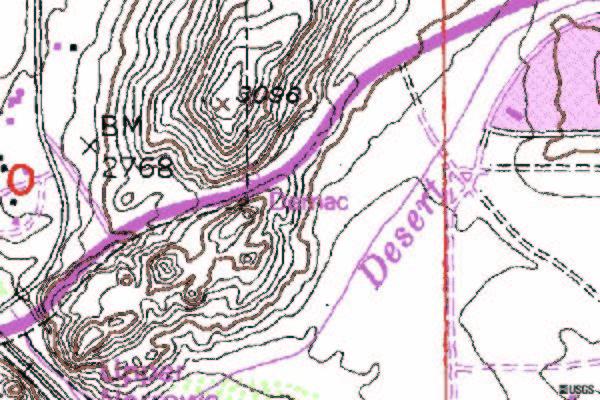
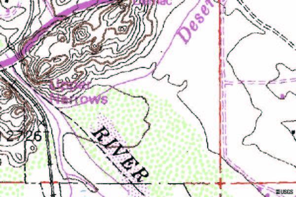
3 Upper Mojave River Narrows, Apple Valley-Victorville, California, United States, 29 May 1994 Lat. 34N 31' 56" ,821,200.0 Long. 117W 17' 00" ,000.0
4
. Introduction: All of the organisms that you ll observe in the Wildlands are adapted to particular set of living conditions, or plant community/habitat.")
5 Where the Wild Things Live2 Objective: Provided with a basic map of the campus, students will locate, map and identify, using a simple key, the various plant communities/habitats present on the Mojave River Campus (MRC). Introduction: All of the organisms that you ll observe in the Wildlands are adapted to particular set of living conditions, or plant community/habitat. Some organisms are able to live within one plant community/habitat year-round. Some species find it necessary to switch plant community/habitats at different times of day or year due local or regional environmental changes. Some migratory organisms, in fact have to switch regions and even continents to find conditions suitable for their survival. The Mojave River Wildlands (MRW) includes several diverse plant community/habitat within one ecosystem (desert-riparian). Habitats can be described in different ways. To tell them apart you ll use plant communities and the existence of water. There are many different plant communities in the MRW. For the purpose of this lesson you ll classify or group the plant community types 3 into 3 main habitat groupings (based on available water) and 11 specific habitats (based on the plants supported). Terrestrial Habitats 1. Urban (developed) 2. Rocky cliffs, outcrops, and boulder fields (Boulder and Rock Field) MOJAVE DESERT SCRUB HABITAT 3. Saltbrush Scrubland (Desert Saltbush Scrub [Atriplex spp.] ) 4. Mojave Desert Scrub (Creosote Bush Scrub [Larrea tridentata], (Saltbush - Creosote Bush 5. Disturbed Scrubland [Larrea tridentata-atriplex polycarpa]) RIPARIAN AND BOTTOMLAND HABITAT 6. Cottonwood-willow forest (Fremont Cottonwood Riparian Woodland [Populus fremontii] Mojave Riparian) Wetland Habitats MEADOWS and SEEPS HABITAT 7. Wet Meadow 8. Seep MARSH HABITAT 9. Marsh Bulrush - Cattail Wetland [Scirpus spp.-typha spp.]) Aquatic Habitats 10. Pond (Lacustrine) 11. River (Riverine) Mapping Habitats: On the map of the MRC Wildlands provided, sketch the major plant community/habitat boundaries and indicate using a key/legend and color code the basic habitat types. 2 Adapted from 3 From
TEST NAME: Biome Test 10/7 TEST ID: GRADE:05 - Fifth Grade SUBJECT:Life and Physical Sciences TEST CATEGORY: My Classroom
 TEST NAME: Biome Test 10/7 TEST ID:1239163 GRADE:05 - Fifth Grade SUBJECT:Life and Physical Sciences TEST CATEGORY: My Classroom Biome Test 10/7 Page 1 of 8 10/07/16, Biome Test 10/7 Student: Class: Date:
Lesson 9: California Ecosystem and Geography
 California Education Standards: Kindergarten, Earth Sciences 3. Earth is composed of land air, and water. As a basis for understanding this concept: b. Students know changes in weather occur from day to
Organism Interactions in Ecosystems
 Organism Interactions in Ecosystems Have you ever grown a plant or taken care of a pet? If so, you know they have certain needs such as water or warmth. Plants need sunlight to grow. Animals need food
Ecosystems Chapter 4. What is an Ecosystem? Section 4-1
 Ecosystems Chapter 4 What is an Ecosystem? Section 4-1 Ecosystems Key Idea: An ecosystem includes a community of organisms and their physical environment. A community is a group of various species that
AS 410 Land Navigation. Chpt 4-1
 AS 410 Land Navigation Chpt 4-1 Overview Types of Maps Map Legends / Scales Latitude and Longitude Orienteering Why? Why important to learn how to read a compass and map? No cell phone coverage Mountain
SIF_7.1_v2. Indicator. Measurement. What should the measurement tell us?
 Indicator 7 Area of natural and semi-natural habitat Measurement 7.1 Area of natural and semi-natural habitat What should the measurement tell us? Natural habitats are considered the land and water areas
Pee Dee Explorer. Science Standards
 Science Standards About Pee Dee Explorer What does it mean when someone says they are from the "Pee Dee" of South Carolina? A place is bigger than its physical geography. A "sense of place" weaves together
*Record Sheets *Notebook entries/drawings *Discussion. *Record Sheets *Notebook entries/drawings *Teacher observation *Discussion
 Grade 4 Curriculum map Life Science: Animal Studies - Carolina Biological Key concepts Standards Assessments Content Skills Lessons Students will Students will demonstrate their Students will know Students
Parts of a Map. Map Skills. The Title. There are 4 main parts of a map: The Title The Compass Rose The Map Key The Scale
 Map Skills Parts of a Map There are 4 main parts of a map: The Title The Compass Rose The Map Key The Scale The Title The title of the map is usually at the top and describes the topic of the map Example:
Environments and Ecosystems
 Environments and Ecosystems A habitat is a place where organisms naturally live and grow. Habitats include biotic, living factors, such as plants and animals and abiotic, non-living factors, such as rocks,
Map Projections & Coordinate Systems
 Map Projections & Coordinate Systems 9/7/2017 1 Why? Laying the Earth Flat Need convenient means of measuring and comparing distances, directions, areas, shapes. Traditional surveying instruments measure
Biodiversity. IN: Using humans as an example, explain what it means to be diverse. Which do you like better? Which do you like better?
 IN: Using humans as an example, explain what it means to be diverse. 1 What do you think biodiversity means? What does io mean? io = What does Diversity mean? Diversity = Variety 2 I. = the number and
CURRICULUM UNIT MAP 1 st QUARTER. COURSE TITLE: Science GRADE: 4
 1 st Unit: Scientific Method Know the seven steps of the scientific method The students will complete a study guide of and use them to solve scientific problems the 7 steps Identify the problem, form a
LANDSCAPE CHANGE IN THE SOUTHWEST: Historical changes in selected ecosystems of the southwestern United States
 LANDSCAPE CHANGE IN THE SOUTHWEST: Historical changes in selected ecosystems of the southwestern United States Robert H. Webb U.S. Geological Survey 520 N. Park Avenue Tucson, AZ 85719 rhwebb@usgs.gov
Evaluating Wildlife Habitats
 Lesson C5 4 Evaluating Wildlife Habitats Unit C. Animal Wildlife Management Problem Area 5. Game Animals Management Lesson 4. Evaluating Wildlife Habitats New Mexico Content Standard: Pathway Strand: Natural
Ecology. Ecology terminology Biomes Succession Energy flow in ecosystems Loss of energy in a food chain
 Ecology Ecology terminology Biomes Succession Energy flow in ecosystems Loss of energy in a food chain Terminology Ecology- the study of the interactions of living organisms with one another and with their
3rd Grade Standards Correlated to Classes at McDowell Environmental Center
 3rd Grade Standards Correlated to Classes at McDowell Environmental Center Aquatic Adventures 3-LS1-1. Develop models to describe that organisms have unique and diverse life cycles but all have in common,
Map Reading & Compass Use
 Spring 2013 Kestrel Land Trust Page 2 / 10 Contents Map Basics... 3 Map Types... 3 Terrain Association... 4 Estimating Distance: Pacing... 4 Contour Lines... 5 Navigating with a Compass... 6 Compass Types...
Elementary Social Studies Content Area Assessment Task. Winter 2010 EDUC 203
 1 Elementary Social Studies Content Area Assessment Task Winter 2010 EDUC 203 Students: Fourth grade class in Watsonville, CA. Approximately 90% Latino, primarily of Mexicandescent. About 80% participate
Define Ecology. study of the interactions that take place among organisms and their environment
 Ecology Define Ecology Define Ecology study of the interactions that take place among organisms and their environment Describe each of the following terms: Biosphere Biotic Abiotic Describe each of the
Unit 7: What is an ecosystem?
 Unit 7: What is an ecosystem? Lesson 20 An ecosystem is an area or habitat that contains living and non-living things. The living and non-living things depend on each other in many different ways. An ecosystem
Regional Project Location and Sediment Removal Truck Routes
 Rd Cheseboro Existing Quarries Water District Property 138 Avenue T 14 47th St Barrel Springs Rd KERN CO. LOS ANGELES CO. 14 PROJECT SITE PROJECT SITE Project Site Water District Property Existing Quarries
Terrestrial Flora and Fauna
 Terrestrial Flora & Fauna Part I In short, the animal and vegetable lines, diverging widely above, join below in a loop. 1 Asa Gray Terrestrial Flora and Fauna Ecosystems and Biomes Terrestrial Flora Terrestrial
Field Guide: Teacher Notes
 Field Guide: Teacher Notes Bob Winters Adaptations of organisms Objectives After completing this activity, students will be able to: Identify physical conditions of grasslands. Evaluate how organisms have
Wetland and Riparian Mapping: An Overview of the Montana Program
 Wetland and Riparian Mapping: An Overview of the Montana Program Meghan Burns, Catherine McIntyre, Karen Newlon Ecology Program Montana Natural Heritage Program Helena, MT Montana Natural Heritage Program
Wonders of the Rainforest Resource Book
 E-BOOK CODE: REAU5021 Special School Photocopy Master Edition Wonders of the Rainforest Resource Book IMSI by Jane Bourke Wonders of the Rainforest Contents Contents... 3 Learning About Rainforests...
CHAPTER 6 & 7 VOCABULARY
 CHAPTER 6 & 7 VOCABULARY 1. Biome 2. Climate 3. Latitude 4. Altitude 5. Emergent layer 6. Epiphyte 7. Understory 8. Permafrost 9. Wetland 10.Plankton 11.Nekton 12.Benthos 13.Littoral zone 14.Benthic zone
BIOMES. Copyright Cmassengale
 BIOMES Continental drift - slow motion of continents Dispersal of organisms Movement of organisms from 1 place to another Dispersal is usually caused by wind, water or living things Species that evolve
Habitat destruction by IAS Flora. Siril Wijesundara Research Professor National Institute of Fundamental Studies Kandy, Sri Lanka
 Habitat destruction by IAS Flora Siril Wijesundara Research Professor National Institute of Fundamental Studies Kandy, Sri Lanka Invasive species can cause significant changes to ecosystems, upset the
Organism Species Population Community Ecosystem
 Name: Date: Period: Ecosystems and Their Interactions S8.B.3.1 Getting the idea The environment is everything that surrounds an organism. Organisms cooperate and compete with each other to get everything
Lab 2 The reinvasion of flowering plants into aquatic habitats
 Lab 2 The reinvasion of flowering plants into aquatic habitats BIOL 3601: PLANT DIVERSITY Lab Goals: To learn about adaptations of aquatic plants in different aquatic zones To learn common aquatic plants
COMMON CORE Lessons & Activities
 T E AC H I T SA M PL E COMMON CORE Lessons & Activities DAY! O T Common Core Lessons & Activities: Ecosystems By Carole Marsh Published by Gallopade International, Inc. Carole Marsh/Gallopade Printed in
Topographic Map Series:
 DEFINITION OF A MAP A MAP IS A GEOGRAPHIC PREPRESENTATION OF A PORTION OF THE EARTH S SURFACE DRAWN TO SCALE, AS SEEN FROM ABOVE. IT S USES COLORS, SYMBOLS AND LABELS TO REPRESENT FEATURES FOUND ON THE
INTERACTIONS IN AN ENVIRONMENT
 reflect Earth is full of living things. Our planet has many kinds of organisms including bacteria, fungi (like mushrooms), plants, and animals. In some ways, living things are alike. Almost all living
Lecture 1: Introduction to Ecology, Levels of Organisation
 DEFINITION OF TERMS Lecture 1: Introduction to Ecology, Levels of Organisation Ecology Habitat Niche Population Community Ecosystem ECOLOGY this is the study of relationships of living organisms with each
What Do You See? FOR 274: Forest Measurements and Inventory. Area Determination: Frequency and Cover
 What Do You See? Message of the Day: Many options exist to determine the size, area, or extent of a feature on a landscape FOR 274: Forest Measurements and Inventory Lecture 7: Measures of Land Area Frequency
Biomes and Biodiversity
 Biomes and Biodiversity Agenda 2/4/13 Biomes review terrestrial and aquatic Biodiversity Climate Change Introduction Weather Terrestrial Biomes Review Tundra Boreal Forest (Taiga) Temperate Forest Temperate
* We will go as a class to the bathroom at 8:18!
 Unpack/ Write down homework Turn in ANY papers from home Get computer & book boxes Work on Government Shortcut--DUE THURSDAY! Work on ANY unfinished work- DUE THURSDAY * We will go as a class to the bathroom
Global Patterns Gaston, K.J Nature 405. Benefit Diversity. Threats to Biodiversity
 Biodiversity Definitions the variability among living organisms from all sources, including, 'inter alia', terrestrial, marine, and other aquatic ecosystems, and the ecological complexes of which they
Biomes Section 1. Chapter 6: Biomes Section 1: What is a Biome? DAY ONE
 Chapter 6: Biomes Section 1: What is a Biome? DAY ONE What is a Biome? Biomes are large regions characterized by a specific type of climate and certain types of plant and animal communities. The climate
Using Map and Compass Together
 Using Map and Compass Together In situations where you foresee a potential evacuation on foot, where there are no roads, and no indication as to the direction of travel (i.e., road signs), it is recommended
Review. Community and Ecosystem Ecology 4/20/11. by Dr. W.
 Review Community and Ecosystem Ecology by Dr. W. A population is the set of all members of one species in a defined area. A community is the set of all populations in a defined area. An ecosystem includes
BIOMES. Copyright Cmassengale
 BIOMES Biogeography - study of where organisms live Continental drift - slow motion of continents Dispersal of organisms Movement of organisms from 1 place to another Dispersal is usually caused by wind,
3 Communities, Biomes, and Ecosystems BIGIDEA Write the Big Idea for this chapter.
 3 Communities, Biomes, and Ecosystems BIGIDEA Write the Big Idea for this chapter. Use the What I Know column to list the things you know about the Big Idea. Then list the questions you have about the
PENNSYLVANIA. How living things interact with each other and the non-living components of the environment. Page 1 of 6. S11.A.1.3.
 Know: Understand: Do: 4.1.12.A.a -- Essential Analyze the significance of biological diversity in an ecosystem. How living things interact with each other and the non-living components of the environment.
Map Projections & Coordinate Systems 9/10/2013. Why? M. Helper GEO327G/386G, UT Austin 2. M. Helper GEO327G/386G, UT Austin 4
 Map Projections & Coordinates Laing the earth flat Wh? Need convenient means of measuring and comparing distances, directions, areas, shapes. Traditional surveing instruments measure in meters or feet,
Historical Ecology of the lower Santa Clara River, Ventura River, and Oxnard Plain: an analysis of terrestrial, riverine, and coastal habitats
 Technical Report 0662 Historical Ecology of the lower Santa Clara River, Ventura River, and Oxnard Plain: an analysis of terrestrial, riverine, and coastal habitats Erin Beller 1, Robin Grossinger 1, Micha
Compass Basics. Quick Map Basics Review For Compass Use
 Compass Basics Quick Map Basics Review For Compass Use A topographic map tells you where things are and how to get to them, whether you're hiking, biking, hunting, fishing, or just interested in the world
Science Standards of Learning for Virginia Public Schools
 Standards of Learning for Virginia Public Schools Reasoning, and Logic Life Processes Earth Patterns, Cycles, and Change Kindergarten Key Concepts Rainforest Desert K.1 The student will conduct investigations
Moreton Bay and Key Geographic Concepts Worksheet
 Moreton Bay and Key Geographic Concepts Worksheet The Australian Curriculum: Geography draws on seven key geographic concepts: place scale space environment change interconnection sustainability They are
Navigating with Map & Compass. Nevada County Sheriff s Search & Rescue
 Navigating with Map & Compass Nevada County Sheriff s Search & Rescue Objectives Very Practical Teach you how to go from point A to point B Go from the wilderness (real world) to a map and visa versa Agenda
B. Topographic maps are also called. contour maps
 Topographic Maps Introduction A. Topographic maps are essential tools in geologic and engineering studies because they show the configuration of Earth's surface in remarkable detail and permit one to measure
Appendix J Vegetation Change Analysis Methodology
 Appendix J Vegetation Change Analysis Methodology Regional Groundwater Storage and Recovery Project Draft EIR Appendix-J April 2013 APPENDIX J- LAKE MERCED VEGETATION CHANGE ANALYSIS METHODOLOGY Building
Navigating for Scouts A Self-teaching Guide to Navigation with Map and Compass
 Don Burgess, November 2003 Materials topographic maps Navigating for Scouts A Self-teaching Guide to Navigation with Map and Compass metric ruler orienteering compass 30 M/5 Hamilton-Burlington 41 I/13
Note: This validation is designed to test the accuracy of the mapping process (i.e. the map models) not the accuracy of the map itself.
 not the accuracy of the map itself.") Ecological Classes and Criteria for Assigning Fuzzy Set Values Fuzzy set validation assessment is being used to evaluate land cover mapping by comparing the label of reference point to map. The validation
Ecological Classes and Criteria for Assigning Fuzzy Set Values Fuzzy set validation assessment is being used to evaluate land cover mapping by comparing the label of reference point to map. The validation
Chapter 52 An Introduction to Ecology and the Biosphere
 Chapter 52 An Introduction to Ecology and the Biosphere Ecology The study of the interactions between organisms and their environment. Ecology Integrates all areas of biological research and informs environmental
South Carolina Curriculum Standards correlated to Reading Essentials in Science Perfection Learning Corporation
 5th Grade Curriculum Standards Air and Wind Earth Movements Soil Science Water, Water, Everywhere What's Up with the Weather? The Earth The Journey into Space The Moon The Solar System The Sun Earthquakes
Biosphere Biome Ecosystem Community Population Organism
 Ecology ecology - The study of living things and how they relate to their environment Levels of Organization in Ecology organism lowest level one living thing population collection of organisms of the
Chapter 3 Models of the Earth. 3.1 Finding Locations on the Earth. 3.1 Objectives
 Chapter 3 Models of the Earth 3.1 Finding Locations on the Earth 3.1 Objectives Explain latitude and longitude. How can latitude and longitude be used to find locations on Earth? How can a magnetic compass
United States Department of the Interior NATIONAL PARK SERVICE Northeast Region
 United States Department of the Interior NATIONAL PARK SERVICE Northeast Region June 17, 2017 REQUEST FOR STATEMENTS OF INTEREST and QUALIFICATIONS Project Title: ASSESSMENT OF NATURAL RESOURCE CONDITION
Map Projections & Coordinate Systems 9/7/2017
 Map Projections & Coordinate Sstems Laing the Earth Flat Wh? Need convenient means of measuring and comparing distances, directions, areas, shapes. Traditional surveing instruments measure in meters or
What is it like living in each of the regions in Alberta?
 Chapter 1 4.1 Alberta: A Sense of the Land I can show how parts of Alberta s physical geography and climate are important to the landscapes and environment of Alberta. I can show where Alberta located
Virginia Standards of Learning correlated to Reading Essentials in Science Perfection Learning Corporation
 Earthquakes Floods Tornadoes Hurricanes Volcanoes Are We Alone? The Case for Extraterrestrial Life Inside a Star Lights in the Sky Mysteries in Space: Cosmic Puzzles Telescopes: Exploring the Beyond Fossils
Earth History Teacher Rubrics and Directions
 Earth History Teacher Rubrics and Directions 1.a. Using the tools provided, observe the three rock samples, A, B, and C. One is sandstone, one is shale, and one is limestone. Make a chart to record your
Chapter 52: An Introduction to Ecology and the Biosphere
 AP Biology Guided Reading Name Chapter 52: An Introduction to Ecology and the Biosphere Overview 1. What is ecology? 2. Study Figure 52.2. It shows the different levels of the biological hierarchy studied
Abiotic Dominant Dominant Factors Plants Animals
 TERRESTRIAL BIOMES Abiotic Dominant Dominant Factors Plants Animals Tropical Rain Forest Hot & wet year round Ferns Woody vines Broad leaved evergreen trees Sloths Jaguars Monkeys Toucans Tropical Dry
EAGLES NEST AND PIASA ISLANDS
 EAGLES NEST AND PIASA ISLANDS HABITAT REHABILITATION AND ENHANCEMENT PROJECT MADISON AND JERSEY COUNTIES, ILLINOIS ENVIRONMENTAL MANAGEMENT PROGRAM ST. LOUIS DISTRICT FACT SHEET I. LOCATION The proposed
Science Grade 3 Assessment Anchors and Eligible Content
 Science Grade 3 Assessment Anchors and Eligible Content Pennsylvania Department of Education www.education.state.pa.us 2010 S.3.A The Nature of Science S.3.A.1 Reasoning and Analysis S.3.A.1.1 Identify
Environmental Science
 Environmental Science A Study of Interrelationships Cui Jiansheng Hebei University of Science and Technology CH06 Kinds of Ecosystems and Communities Chapter Objectives After reading this chapter, you
Geographical Information Systems
 Geographical Information Systems Geographical Information Systems (GIS) is a relatively new technology that is now prominent in the ecological sciences. This tool allows users to map geographic features
Map Projections & Coordinate Systems 1/25/2018
 Map Projections & Coordinate Sstems Laing the Earth Flat How? Projections transformation of curved earth to a flat map; sstematic rendering of the lat. & lon. graticule to rectangular coordinate sstem.
Ms. A. Mormando's Class *
 8 th Grade Science Essential Standard: 8.E.1.1 Explain the structure of the hydrosphere including: Water distribution on Earth; Local river basin and water availability Stream - A stream is a body of water
Introduction. Ecology is the scientific study of the interactions between organisms and their environment.
 Introduction Ecology is the scientific study of the interactions between organisms and their environment. 1. The interactions between organisms and their environments determine the distribution and abundance
EXPLORER S GUIDE FOR A SELF-GUIDED VISIT. Welcome to the Arizona-Sonora Desert Museum!
 EXPLORER S GUIDE FOR A SELF-GUIDED VISIT Welcome to the Arizona-Sonora Desert Museum! Instructions: Review the questions in this guide before you visit the Desert Museum. You should be able to find all
Basic Land Navigation
 A Publication of the National Wildfire Coordinating Group National Interagency Incident Management System Basic Land Navigation PMS 475 June 2007 NFES 2865 Basic Land Navigation JUNE 2007 NFES 2865 Sponsored
Basic Map Skills for the Outdoors
 Geography 80-20 80% of what there is to know, for 20% of the sweat Basic Map Skills for the Outdoors Map Scale Map source: US Geological Survey Four ways to indicate map scale: Representative fraction
Earth s Major Terrerstrial Biomes. *Wetlands (found all over Earth)
") Biomes Biome: the major types of terrestrial ecosystems determined primarily by climate 2 main factors: Depends on ; proximity to ocean; and air and ocean circulation patterns Similar traits of plants
Biomes Biome: the major types of terrestrial ecosystems determined primarily by climate 2 main factors: Depends on ; proximity to ocean; and air and ocean circulation patterns Similar traits of plants
Name Hour. Section 4-1 The Role of Climate (pages 87-89) What Is Climate? (page 87) 1. How is weather different from climate?
 What Is Climate? (page 87) 1. How is weather different from climate?") Name Hour Section 4-1 The Role of Climate (pages 87-89) What Is Climate? (page 87) 1. How is weather different from climate? 2. What factors cause climate? The Greenhouse Effect (page 87) 3. Circle the
Name Hour Section 4-1 The Role of Climate (pages 87-89) What Is Climate? (page 87) 1. How is weather different from climate? 2. What factors cause climate? The Greenhouse Effect (page 87) 3. Circle the
UNIT 5: ECOLOGY Chapter 15: The Biosphere
 CORNELL NOTES Directions: You must create a minimum of 5 questions in this column per page (average). Use these to study your notes and prepare for tests and quizzes. Notes will be stamped after each assigned
Name: Class: Date: Ecosystem Interactions. Multiple Choice Identify the choice that best completes the statement or answers the question.
 Name: Class: _ Date: Ecosystem Interactions Multiple Choice Identify the choice that best completes the statement or answers the question. 1. In an ecosystem, organism interact with living and non-living
Changes to Land 5.7B. landforms: features on the surface of Earth such as mountains, hills, dunes, oceans and rivers
 All the landforms on Earth have changed over time and continue to change. Many of the changes were caused by wind, moving water, and moving ice. Mountains have grown and shrunk. Rivers have cut away land
TUNKHANNOCK AREA SCHOOL DISTRICT SCIENCE CURRIULUM GRADE 2
 TUNKHANNOCK AREA SCHOOL DISTRICT SCIENCE CURRIULUM GRADE 2 Chapter 4 (How Living Things Grow and Change) 3.1.2.C.2. Explain that living things can only survive if their needs are being met. 3.1.2.A.3.
Think about the landforms where you live. How do you think they have changed over time? How do you think they will change in the future?
 reflect All the landforms on Earth have changed over time and continue to change. Many of the changes were caused by wind, moving water, and moving ice. Mountains have grown and shrunk. Rivers have cut
Most people used to live like this
 Urbanization Most people used to live like this Increasingly people live like this. For the first time in history, there are now more urban residents than rural residents. Land Cover & Land Use Land cover
Chapter 7 Part III: Biomes
 Chapter 7 Part III: Biomes Biomes Biome: the major types of terrestrial ecosystems determined primarily by climate 2 main factors: Temperature and precipitation Depends on latitude or altitude; proximity
use limited written language, spoken language, numbers, or labeled drawings to describe observed objects and phenomena. (N.2.A.1)
") N.2.A.1 Students know how to make observations and give descriptions using words, numbers, and drawings. Science Achievement Indicators Grade Span Content Standard N2A Students understand that science
N.2.A.1 Students know how to make observations and give descriptions using words, numbers, and drawings. Science Achievement Indicators Grade Span Content Standard N2A Students understand that science
BLUE VALLEY DISTRICT CURRICULUM Science Grade 3
 BLUE VALLEY DISTRICT CURRICULUM Science Grade 3 ORGANIZING THEME/TOPIC Unit 1: Weather Patterns and Predictions Unit 3: Weather and Climate Lessons 1-5 Suggested Time Frame: 39 days Unit 2: Climates of
Geography and the Early Settlement of China
 Geography and the Early Settlement of I N T E R A C T I V E S T U D E N T N O T E B O O K How did geography affect life in ancient? P R E V I E W Physical Features 1. Circle the physical features that
Name period date assigned date due date returned. Texas Ecoregions
 Name period date assigned date due date returned Directions: Go to the following website: https://www-k6.thinkcentral.com/epc/start.do Use the log in that is taped to the top of your laptop. If you are
Adventure Racing Navigation Supplies. Table Top Adventure Race & Navigation Challenge. Preview
 Adventure Racing Navigation Supplies Table Top Adventure Race & Navigation Challenge 12 Navigation Challenges for Map and Compass Navigation Volume 1. June 2009 Presented by AR Navigation Supplies, Inc.
Ontario Science Curriculum Grade 9 Academic
 Grade 9 Academic Use this title as a reference tool. SCIENCE Reproduction describe cell division, including mitosis, as part of the cell cycle, including the roles of the nucleus, cell membrane, and organelles
Name: Date: Class: Louisiana: Our History, Our Home Chapter 1: Louisiana s Geography - Section 2: Natural Regions Guided Reading
 Instructions: Read the section and complete each item with words from the passages in this section. 1. The diversity of Louisiana s can surprise residents and visitors alike. 2. Physical geography is concerned
Elementary Science Curriculum- First Grade
 Unit: Life Science Time Frame: 32 days Standard: 5.3 Life Science All students will understand that life science principles are powerful conceptual tools for making sense of the complexity, diversity,
LAKE BILLY CHINOOK by: Steve Fisher. Oregon Geography Content Standards (grade 5):
:") LAKE BILLY CHINOOK by: Steve Fisher OVERVIEW: In this lesson students use historical maps, aerial photographs, personal observation, sketches and oral history to investigate the impact of the damming of
LAKE BILLY CHINOOK by: Steve Fisher OVERVIEW: In this lesson students use historical maps, aerial photographs, personal observation, sketches and oral history to investigate the impact of the damming of
FOOD WEB. WHY IS THE SUN AT THE BOTTOM? IS THE ALLIGATOR THE LAST LIVING BEING IN THE WEB?
 FOOD WEB http://trinityeverglades.weebly.com WHY IS THE SUN AT THE BOTTOM? IS THE ALLIGATOR THE LAST LIVING BEING IN THE WEB? www.emaze.com FOOD CHAINS (SIMPLER AND LINEAR) AIR (N 2, O 2, CO 2 ) FUNGI
Name Hour. Chapter 4 Review
 Name Hour Chapter 4 Review 1. The average, year-after-year conditions of temperature and precipitation within a particular region are its weather. climate. greenhouse effect. d. biotic factors. 2. The
Ganado Unified School District (Science/Kindergarten)
") 1 st Quarter (July 31 st October 4 th, 2018) 1 st Quarter (8 Performance Objectives) Strand 1: Inquiry Process, Strand 2: History and Nature of Science, Strand 3: Science in Personal and Social Perspectives,
1 st Quarter (July 31 st October 4 th, 2018) 1 st Quarter (8 Performance Objectives) Strand 1: Inquiry Process, Strand 2: History and Nature of Science, Strand 3: Science in Personal and Social Perspectives,
Living Things and the Environment
 Unit 21.1 Living Things and the Environment Section 21.1 Organisms obtain food, water, shelter, and other things it needs to live, grow, and reproduce from its environment. An environment that provides
Curriculum Links AS and A level Field Studies
 Equipment Includes Human Geography Coastal Management Students examine the conflicts that arise from coastal erosion and the options for coastal management. They investigate different types of coastal
Materials: 3 sets of cards, a teacher key, vocabulary list or glossary ((Vocabulary list is also available online below the corresponding program))
)") I Have, Who Has? An Interactive Vocabulary Game Woodland Ecosystem Study Vocabulary Grades 4 th -8th Introduction: Below is a collection of cards that connect to the Woodland Ecosystem Study Vocabulary
I Have, Who Has? An Interactive Vocabulary Game Woodland Ecosystem Study Vocabulary Grades 4 th -8th Introduction: Below is a collection of cards that connect to the Woodland Ecosystem Study Vocabulary