Delaware Recommended Curriculum Grade 7 Geography Standard 4b. Authors/Editors: Kristin Schlegel Maggie Legates
|
|
|
- Ruth Underwood
- 5 years ago
- Views:
Transcription


1 Delaware Recommended Curriculum Grade 7 Geography Standard 4b Authors/Editors: Kristin Schlegel Maggie Legates


2 THIS UNIT WAS ADAPTED FROM BEYOND BORDERS A UNIT FOR MIDDLE GRADES FROM This unit was originally created as part of the National Teacher Leadership Academy (NTLA) NG Education's signature professional development program for teachers.


3 SUPPORT FOR THE DEVELOPMENT OF THIS UNIT CAME FROM:
4 TODAY S GOALS Add to knowledge and appreciation of geographic principles Showcase good lessons and activities, instructional materials Share assessment tools, differentiation opportunities, extensions and adaptations. Collaborate, network, and grow!
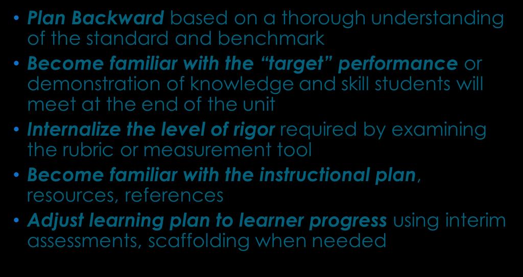
5 DRC PRINCIPLES

6
7 GEOGRAPHY STANDARD 4B 6-8: BENCHMARK : Students will explain how conflict and cooperation among people contribute to the division of the Earth s surface into distinctive cultural and political territories.
8 BIG IDEAS: Territory Borders Boundaries
9 UNIT ENDURING UNDERSTANDINGS: Borders define political regions; political borders are hard to change. Boundaries of cultural regions are usually blurry and subject to change.
10 UNIT ESSENTIAL QUESTIONS How are borders defined? When two countries share ownership of a river, who gets to decide how to care for the river?
11 KNOWLEDGE AND SKILLS Students will know Definitions and examples of formal, functional and perceptual regions Definitions and examples of cultural, physical, and economic regions Examples of borders that follow physical features and abstract borders Expressions of cooperation (shared access, trade, international ventures) Expressions of conflict (Legal disputes, political unrest, military action) Examples of political borders that changed over time
12 Students will be able to Suggest borders or regional boundaries that will minimize conflict Identify or predict the likely result of a proposed border or boundary change
13 STAGE TWO: TRANSFER TASK AND RUBRIC Now that you have learned about territory and how conflicts and cooperation can influence the drawing of borders, it s time to demonstrate your understanding
14 The Kurds are a cultural group in the Middle East. They have their own language and customs. Most of them live in the mountains where the borders of Turkey, Iran and Iraq meet. This highland area is the source of rivers that flow into Iraq, Turkey and Iran. Oil deposits are also found in Kurdish areas. But the Kurds do not have their own country. Instead, Kurdish territory is divided among Turkey, Syria, Iraq, and Iran. The Kurds are a minority group in each of the four neighboring countries. Many Kurds would like to have a country where they are the majority, and Kurdish culture would be valued and supported.

15 Some people are proposing a new country called Kurdistan. The boundaries of this proposed country are shown in the map. The new country would include parts of Turkey, Iraq and Iran. Supporters of this plan claim that redrawing the map will solve problems. But will it cause more problems than it solves? You be the judge!

16 TAKE A STAND ON KURDISH INDEPENDENCE!
17 PRODUCTS AND PERFORMANCE: You have been invited to share your views on the proposed new country in a video clip for your student TV station. For your clip to be aired, you must clearly take a side for or against independence. Develop a set of up to 5 talking points. Write out your main ideas and key facts you want to remember to mention. For maximum effect, use the key words territory, border, conflict and cooperation in your presentation Prepare one slide or poster to be shown during a cut-away during your presentation. Select the photos, map or other graphic carefully to support your talking points. Your talking points and visual will be submitted to the show producers in advance of the interview.
18 Score Point Understanding of Territorial Expression of Culture is Rubric Basic or unevenly applied to the aspects of the issue. OR Student takes no position on this issue of cultural territorial expression Evident, but vocabulary related to culture or territory may be applied inappropriately or be missing from the presentation Evident in either talking points or visual. Geographic terms are generally used well. clearly evident in talking points and supported by visual. Geographic words are correctly used. Understanding of Conflict and Cooperation in relation with Boundaries and Borders is Basic, but evident; no references to the map or facts provided. OR The student takes no position on the effect of changing the international borders. Evident, but vocabulary related to borders, conflicts and cooperation may be missing or inaccurately applied. Clearly evident and vocabulary is used appropriately in talking points or. Visual Clearly evident and vocabulary is used appropriately.. The visual clearly reinforces ideas od border conflict or cooperation. Understanding effects of border changes. References to the effects of border changes are Basic and do not refer to effects of changes in cultural life in regions. Are evident. Some reference is made to the effects of discrepancies between cultural regions and political borders. Are evident. References to potential effects of border changes are supported by references to data or visuals. Are evident. References to potential effects of border changes are supported by references to data and visuals.
19
20 Essential Question Why are borders located where they are? This lesson is adapted with permission for the Delaware Recommended Curriculum from National Geographic s Beyond Borders: Exploring European Physical and Cultural Landscapes in Grades 6-8.
21 TERRITORY An area of the earth s surface with which people identify culturally or politically is termed a territory.
22 Important Concepts Border: An imaginary line separating one political division, such as a country, state, province or county, from another Country: A recognized territory whose government is the highest legal authority over the land and the people living within its boundaries Region: An area with one or more common characteristics or features, which give it a measure of homogeneity and make it different from surrounding areas
23 TEACHING STRATEGIES: Think-Pair-Share- Crossing the Border Extending and Refining- Drawing Political Borders Think-Pair-Square Discussion- Missing Info
 the river?")
24 Essential Question When two countries share ownership of a river, who decides how to care for (or control) the river?
25 IMPORTANT CONCEPTS Conflict: Incompatibility of one idea, desire, event, or activity with another Dams: Structures built across a river to control the flow of water Environment: The sum of the conditions that surround and influence an organism Flood: The rising and overflowing of a body of water onto land that is not normally covered with water

26 TEACHING STRATEGIES Gathering Information from a model Scenario: Farmer Brown and Mrs. Jones Gathering information from text and maps Rivers and the Gabc íkovo-nagymaros Project. Extending and Refining -Think-Pair-Square with discussion questions about impacts and effects Laser Talk- present the case of either the Hungarians or the Czechs on the Gabc íkovo- Nagymaros Project.


27 CHECK FOR UNDERSTANDING Why might this project help improve life in your countries? Why it is an example of international cooperation that other countries should follow? Explain the physical geography and the economic and political situation of the area as part of your press release.

28 Essential Question When two countries share ownership of a resource or a territory, who gets to decide how to care for or control the resource or space?
29 TEACHING STRATEGIES: Gathering Information about water from maps Extending and refining understanding about regional conflicts Water in the Middle East: Conflict or Cooperation? (L1010) An additional resource is a downloadable clip from PBS News Hour A Struggle for Water Resources in Middle East Conflict with teacher s guide, posted on October 6, 2010 at url: 0/a_struggle_for_water_resources.html. Application: Take a Stand on Jerusalem Jerusalem: A Holy City by Gale Ekiss, Arizona Geographic Alliance (

30 ARE THEY READY TO TACKLE THE TRANSFER TASK? What will make them more successful?
Your web browser (Safari 7) is out of date. For more security, comfort and. the best experience on this site: Update your browser Ignore
 is out of date. For more security, comfort and. the best experience on this site: Update your browser Ignore") Your web browser (Safari 7) is out of date. For more security, comfort and lesson the best experience on this site: Update your browser Ignore Political Borders Why are the borders of countries located
Your web browser (Safari 7) is out of date. For more security, comfort and lesson the best experience on this site: Update your browser Ignore Political Borders Why are the borders of countries located
Alleghany County Schools Curriculum Guide GRADE/COURSE: World Geography
 GRADE/COURSE: World 2013-14 GRADING PERIOD: 1 st Six Weeks Time Frame Unit/SOLs SOL # Strand Resource Assessment 8 days* The student will use maps, globes, satellite images, photographs, or diagrams to
World Geography Unit Curriculum Document
 Unit Number and Title: Unit 5-Southwest Asia/North Africa (Egypt, Libya, Iraq, Afghanistan, Israel, Saudi Arabia, Iran) Curriculum Concepts: Religious conflict Oil Water Enduring Understandings (Big Ideas):
AP Human Geography Syllabus
 AP Human Geography Syllabus Textbook The Cultural Landscape: An Introduction to Human Geography. Rubenstein, James M. 10 th Edition. Upper Saddle River, N.J.: Prentice Hall 2010 Course Objectives This
Your web browser (Safari 7) is out of date. For more security, comfort and the best experience on this site: Update your browser Ignore
 is out of date. For more security, comfort and the best experience on this site: Update your browser Ignore") Your web browser (Safari 7) is out of date. For more security, comfort and the best experience on this site: Update your browser Ignore Activitydevelop RESEARCH EXAMPL ES O F PHYSICAL GEO GRAPHY How do
Your web browser (Safari 7) is out of date. For more security, comfort and the best experience on this site: Update your browser Ignore Activitydevelop RESEARCH EXAMPL ES O F PHYSICAL GEO GRAPHY How do
Warm up: (8 min) Use the Map, On the Prom (Color) Paper (Blk/White) and answer the questions on your paper
 Use the Map, On the Prom (Color) Paper (Blk/White) and answer the questions on your paper") Warm up: (8 min) Use the Map, On the Prom (Color) Paper (Blk/White) and answer the questions on your paper TX History: Mapping and Geography of Texas: We will discuss some slides and write notes on others
Warm up: (8 min) Use the Map, On the Prom (Color) Paper (Blk/White) and answer the questions on your paper TX History: Mapping and Geography of Texas: We will discuss some slides and write notes on others
6 th Grade: Regions and People of the World ESC Suggested Pacing Guide
 Norton City Schools Standards-Based Social Studies Course of Study 2005 6 th Grade: Regions and People of the World ESC Suggested Pacing Guide 2005-06 The sixth grade year focuses on the study of world
Your web browser (Safari 7) is out of date. For more security, comfort and the best experience on this site: Update your browser Ignore
 is out of date. For more security, comfort and the best experience on this site: Update your browser Ignore") Your web browser (Safari 7) is out of date. For more security, comfort and the best experience on this site: Update your browser Ignore Activityengage O CEAN AND SEA BO RDERS Who has the rights to valuable
Your web browser (Safari 7) is out of date. For more security, comfort and the best experience on this site: Update your browser Ignore Activityengage O CEAN AND SEA BO RDERS Who has the rights to valuable
World Geography Unit Curriculum Document
 Unit Number and Title: Unit 9-Review (including a comparison to North America) Curriculum Concepts: Globalization Culture Democracy Diversity Migration Enduring Understandings (Big Ideas): Time Frame:
WS/FCS Unit Planning Organizer
 WS/FCS Unit Planning Organizer Subject(s) Social Studies Conceptual Lenses Grade/Course 3rd Place Unit of Study Five Themes of Geography Location Unit Title Pacing Geo Explorers 20-22 days Human environment
a. Hunting and gathering SE/TE: 17, 19, 21, 22, 23, 25, 30 b. Tool making SE/TE: 17, 18, 19, 22, 23 c. Use of fire SE/TE: 17, 23, 30
 Ohio Academic Content Standards, Social Studies, Benchmarks and Indicators (Grade 6) Grade Six History Students use materials drawn from the diversity of human experience to analyze and interpret significant
Critical Thinking. about. GeoGRAPHY. United States, Canada, and Greenland. Jayne Freeman
 Critical Thinking about GeoGRAPHY United States, Canada, and Greenland Jayne Freeman WALCH EDUCATION Contents Introduction............................................................... v National Geography
Sample assessment task. Task details. Content description. Year level 7
 Sample assessment task Year level 7 Learning area Subject Title of task Task details Description of task Type of assessment Purpose of assessment Assessment strategy Evidence to be collected Suggested
Grade 6 Social Studies
 Unit Title: Africa : Movement Location Place Human Region : Subject/Course: 6 th Grade Social Studies Essential Questions: peoples, cultures and ideas of the world? How is a location identified using map
Climate Change: How it impacts Canadians and what we can do to slow it down.
 Climate Change: How it impacts Canadians and what we can do to slow it down. Lesson Overview This lesson takes stock of how climate change has already affected Canadians in geographic, economic, and cultural
Why Geography Matters
 Why Geography Matters Vocabulary words geography relative location absolute location physical feature human feature region modify adapt cause effect geography: The study of the Earth s physical and human
6 th Grade: Regions and People of the World ESC Suggested Pacing Guide
 6 th Grade: Regions and People of the World ESC Suggested Pacing Guide 2008-09 The sixth grade year focuses on the study of world regions. The concentration is geographic rather than historic. Students
a division of Teacher Created Materials
 Sample Pages from a division of Teacher Created Materials Thanks for checking us out. Please call us at 877-777-3450 with questions or feedback, or to order this product. You can also order this product
Reading a Map in Any Language. Kathy Sundstedt and Dawn Brown School not available. Content Area (Req.): Geography Unit (Opt.):
: Geography Unit (Opt.):") Instructional Sequence/Procedure (Req.): 1. Distribute one copy of Bangladesh map, written in Bengali, to each student group. 2. Optional project the same map on the wall from transparency, overhead projector,
Instructional Sequence/Procedure (Req.): 1. Distribute one copy of Bangladesh map, written in Bengali, to each student group. 2. Optional project the same map on the wall from transparency, overhead projector,
Geography. Programme of study for key stage 3 and attainment target (This is an extract from The National Curriculum 2007)
") Geography Programme of study for key stage 3 and attainment target (This is an extract from The National Curriculum 2007) Crown copyright 2007 Qualifications and Curriculum Authority 2007 Curriculum aims
Geography Programme of study for key stage 3 and attainment target (This is an extract from The National Curriculum 2007) Crown copyright 2007 Qualifications and Curriculum Authority 2007 Curriculum aims
SOCIAL STUDIES Grade 6 Standard: History
 Standard: History Chronology A. Interpret relationships between events shown on multipletier 1. Construct a multiple-tier time line from a list of events time lines. and interpret the relationships between
The Arctic Ocean. Grade Level: This lesson is appropriate for students in Grades K-5. Time Required: Two class periods for this lesson
 The Arctic Ocean Lesson Overview: This lesson will introduce students to the Eastern Arctic Region and the benefits of the Arctic Ocean to the people who live in the Far North. This lesson can be modified
Many Ways to Name a Place
 Your web browser (Safari 7) is out of date. For more security, comfort and Activityapply the best experience on this site: Update your browser Ignore Many Ways to Name a Place What are the names for the
Dokdo/Takeshima: Who Owns It? Kelly Swanson
 Dokdo/Takeshima: Who Owns It? Kelly Swanson Introduction: The vast majority of Americans, including our students, do not know where Dokdo/Takeshima Islands are located, nonetheless that they are hotly
Saskatchewan s Early Trade Routes: The Impact of Geography on Trade
 Saskatchewan s Early Trade Routes: The Impact of Geography on Trade Lesson Overview In this lesson, students will compare and contrast prehistoric First Nations trade routes and trade goods with the routes
Groveport Madison Local School District Sixth Grade Social Studies Content Standards Planning Sheets
 Standard: Citizenship Rights and Responsibilities A. Show the relationship between civic participation and attainment of civic and public goals. 1. Explain how opportunities for citizens to participate
Looking at Communities: Comparing Urban and Rural Neighborhoods
 Looking at Communities: Comparing Urban and Rural Neighborhoods OVERVIEW & OBJECTIVES Our urban areas have become so dominant that frequently the children we teach have no connection with and very few
Ohio s State Tests ANSWER KEY & SCORING GUIDELINES GRADE 6 SOCIAL STUDIES PART 1
 Ohio s State Tests ANSWER KEY & SCORING GUIDELINES GRADE 6 SOCIAL STUDIES PART 1 Table of Contents Questions 1 4: Content Summary and Answer Key...1 Question 1: Question and Scoring Guidelines...3 Question
Explore! Fossils Original Air Date: January 28, 2015 Grade Levels: 3-6 Archived Program URL: Program Materials Page URL: Program Description:
 Explore! Fossils Original Air Date: January 28, 2015 Grade Levels: 3-6 Archived Program URL: http://www.hectv.org/video/16389/explore-fossils-january-2015/ Program Materials Page URL: http://www.hectv.org/teachers/curriculum/hec-tv-live/explorefossils/
Pacemaker World Geography and Cultures. correlated to. Louisiana Social Studies Grade Level Expectations: World Geography Geography Grades 9-12
 Pacemaker World and Cultures correlated to Louisiana Social Studies Grade Level Expectations: World Grades 9-12 Pacemaker World and Cultures Pearson Learning Group correlated to Louisiana Social Studies
Critical Thinking. about GEOGRAPHY. The Middle East. Jayne Freeman
 Critical Thinking about GEOGRAPHY The Middle East Jayne Freeman WALCH EDUCATION The classroom teacher may reproduce materials in this book for classroom use only. The reproduction of any part for an entire
St John s Catholic Primary School. Geography Policy. Mission Statement
 St John s Catholic Primary School Geography Policy Mission Statement We at St John s strive for excellence in education by providing a safe, secure and caring family environment where individuals are valued
HPISD CURRICULUM (SOCIAL STUDIES, WORLD GEOGRAPHY)
") HPISD CURRICULUM (SOCIAL STUDIES, WORLD GEOGRAPHY) EST. NUMBER OF DAYS: 14 UNIT NAME Unit Overview UNIT 7 SOUTH WEST ASIA/NORTH AFRICA SWANA s geography has led to economic and cultural differences. Students
HPISD CURRICULUM (SOCIAL STUDIES, WORLD GEOGRAPHY) EST. NUMBER OF DAYS: 14 UNIT NAME Unit Overview UNIT 7 SOUTH WEST ASIA/NORTH AFRICA SWANA s geography has led to economic and cultural differences. Students
Subject: Geography Scheme of Work: B1 to B6 Mastery tiles. Term: Autumn/Spring/Summer
 Subject: Geography Scheme of Work: B1 to B6 Mastery tiles Term: Autumn/Spring/Summer Topic / Unit(s) Overview / Context Introduction to geography. An introduction to geography including basic map skills
STUDY GUIDE. Exploring Geography. Chapter 1, Section 1. Terms to Know DRAWING FROM EXPERIENCE ORGANIZING YOUR THOUGHTS
 For use with textbook pages 19 22. Exploring Geography Terms to Know location A specific place on the earth (page 20) absolute location The exact spot at which a place is found on the globe (page 20) hemisphere
How Irrigation Affected the Geography of Northeast Oregon
 Delia Wallis How Irrigation Affected the Geography of Northeast Oregon Grade Levels: 4 (with ability to move up or down) Time: two x 45-minute sessions Overview: Students are going to study topographical
Northwestern Consolidated Schools of Shelby County. Curriculum. World Studies (Eastern Hemisphere) Prepared by. Rich Ballard
 Prepared by. Rich Ballard") Northwestern Consolidated Schools of Shelby County Curriculum World Studies (Eastern Hemisphere) 7th Grade Prepared by Rich Ballard 2012-2013 1 Triton Central Middle School Vision Statement We are committed
Northwestern Consolidated Schools of Shelby County Curriculum World Studies (Eastern Hemisphere) 7th Grade Prepared by Rich Ballard 2012-2013 1 Triton Central Middle School Vision Statement We are committed
MIDDLE TENNESSEE STATE UNIVERSITY Global Studies / Cultural Geography Major Matrix Page 1 of 7
 Page 1 of 7 I. Social Studies Core GS 4990 (3) Senior Seminar in Global Studies SSC 1. Demonstrate critical thinking in the social sciences by GEOG 2000 (1/3) Introduction to Regional Geography posing
The study of Geography and the use of geographic tools help us view the world in new ways.
 S How does Geography help us understand our world? What factors shape the Earth s different environments? 7.1.9 7.2.9 BIG IDEAS COMPETENCIES Text pages or The study of Geography and the use of geographic
Reading a Map in Any Language. Dawn Shattuck NICC; Kathy Sundstedt School not available. Content Area (Req.): Geography Unit (Opt.
: Geography Unit (Opt.") Instructional Sequence/Procedure (Req.): 1. Distribute one copy of Chile map, written in Spanish, to each student group OR direct each group of students to access an online copy of a Chile map. 2. Together,
Instructional Sequence/Procedure (Req.): 1. Distribute one copy of Chile map, written in Spanish, to each student group OR direct each group of students to access an online copy of a Chile map. 2. Together,
European Migration to Tilting, Newfoundland
 European Migration to Tilting, Newfoundland Lesson Overview In this lesson, students will learn about historical connections between Tilting, Newfoundland and Labrador, and Ireland. Using the Canadian
HADDONFIELD PUBLIC SCHOOLS Curriculum Map for Social Studies 7 th Geography Study Skills, Geography & the Five Themes
 Curriculum Map for Social Studies 7 th Geography Study, Geography & the Five Themes NJCCCS 6.1 - Social Studies SEPTEMBER Essential Questions: What are the traits of a student? What study skills maximize
Geography Policy 2014
 Geography Policy 2014 DEFINITION Geography education should inspire in pupils a curiosity and fascination about the world and its people that will remain with them for the rest of their lives. Teaching
Nigeria What is a Region? George Kuhter South Tama County Middle School, Toledo, IA
 Instructional Sequence/Procedure (Req.): 1. Review or introduce the idea of region. The most important idea to stress is that a region is a place or places that have similar physical or human characteristics.
Subject: Geography Unit 1: The Earth
 Subject: Geography Unit 1: The Earth Learning outcomes Activities Resources Thinking Skills Language of Learning The earth s relief and its different forms such as mountains, valleys, plains. The parts
Bruce County s BIG Picture
 Bruce County s BIG Picture Overview Students will learn the importance of this planet we call Earth. Through different topics such as plate tectonics, glacial periods, climate change and endangered species,
HOLY CROSS CATHOLIC PRIMARY SCHOOL
 HOLY CROSS CATHOLIC PRIMARY SCHOOL Geography Policy Date Implemented Jan 17 Review Date Jan 22 Mission Statement Holy Cross Primary School is a Catholic School. We seek to provide a broad, balanced Christian
Historical Fisheries off the Grand Banks (Wet and Dry Fisheries)
") Lesson Overview Historical Fisheries off the Grand Banks (Wet and Dry Fisheries) The French conducted the earliest trans-atlantic fishery with the Portuguese fishermen, soon joined by Basques, who took
Lesson Overview Historical Fisheries off the Grand Banks (Wet and Dry Fisheries) The French conducted the earliest trans-atlantic fishery with the Portuguese fishermen, soon joined by Basques, who took
Anoka Hennepin K 12 Curriculum Unit Plan
 Anoka Hennepin K 12 Curriculum Unit Plan Department: Social Studies Grade Level: 4 Unit Title: Geographic Investigations Trimester: 2 and 3 (16) 55 minute lessons (can be (32) 25 minute lessons) Unit Summary:
Contents and Pedagogy Standard for Geography Teachers ( 9-12)
") Contents and Pedagogy Standard for Geography Teachers ( 9-12) 1. Background The Geography teachers' professional standards presented in this document have been prepared using the generic standard as an
Contents and Pedagogy Standard for Geography Teachers ( 9-12) 1. Background The Geography teachers' professional standards presented in this document have been prepared using the generic standard as an
World History Unit Curriculum Document
 Unit Number and Title: Unit 1: Development of River Valley Civilizations (8000 BC 500 BC) Curriculum Concepts: Civilization Human-Environment Interaction Diffusion Innovation Belief Systems Enduring Understandings
School Program Name: Name of Sanctuary: Grade Level: Grades 6 8 Location Options: Time:
 School Program Name: Name of Sanctuary: Grade Level: Grades 6 8 Location Options: Time: For more info: Landforms of New England Moose Hill Wildlife Sanctuary At the sanctuary 2 hours or combine with another
Your web browser (Safari 7) is out of date. For more security, comfort and the best experience on this site: Update your browser Ignore
 is out of date. For more security, comfort and the best experience on this site: Update your browser Ignore") Your web browser (Safari 7) is out of date. For more security, comfort and the best experience on this site: Update your browser Ignore Activitydevelop RIVERS AND THE GABČÍKOVO - NAGYMARO S PRO JECT Why
Your web browser (Safari 7) is out of date. For more security, comfort and the best experience on this site: Update your browser Ignore Activitydevelop RIVERS AND THE GABČÍKOVO - NAGYMARO S PRO JECT Why
About places and/or important events Landmarks Maps How the land is, hills or flat or mountain range Connected to maps World Different countries
 What do you think you know about geography? About places and/or important events Landmarks Maps How the land is, hills or flat or mountain range Connected to maps World Different countries What do you
Your web browser (Safari 7) is out of date. For more security, comfort and. the best experience on this site: Update your browser Ignore
 is out of date. For more security, comfort and. the best experience on this site: Update your browser Ignore") Your web browser (Safari 7) is out of date. For more security, comfort and Activitydevelop the best experience on this site: Update your browser Ignore Places in the Park Why do we use symbols? Overview
Your web browser (Safari 7) is out of date. For more security, comfort and Activitydevelop the best experience on this site: Update your browser Ignore Places in the Park Why do we use symbols? Overview
Geography for Life. Course Overview
 Geography for Life Description In Geography for Life students will explore the world around them. Using the six essential elements established by the National Geographic Society students will be able to
A Correlation of. Ohio s Learning Standards in Social Studies. Grade 5
 A Correlation of 2019 To in Social Studies Grade 5 Introduction The all new myworld Interactive Social Studies encourages students to explore their world, expand their thinking, and engage their college,
Canadian Mapping Big Book
 Canadian Mapping Big Book Grades 4-6 Written by Lynda Golletz Illustrated by S&S Learning Materials About the Author: Lynda Golletz was an elementary school teacher for thirty-three years. She is the author
European geography and what it can do for the future: the case of a bi-communal project in divided Cyprus
 European geography and what it can do for the future: the case of a bi-communal project in divided Cyprus Stavroula Philippou Assistant Professor (Curriculum & Instruction) Department of Education Sciences
State and National Standard Correlations NGS, NCGIA, ESRI, MCHE
 GEOGRAPHIC INFORMATION SYSTEMS (GIS) COURSE DESCRIPTION SS000044 (1 st or 2 nd Sem.) GEOGRAPHIC INFORMATION SYSTEMS (11, 12) ½ Unit Prerequisite: None This course is an introduction to Geographic Information
correlated to the NEW MEXICO Content Standards and Benchmarks for Ancient History (ANHI) grade 6
 grade 6") correlated to the NEW MEXICO Content Standards and Benchmarks for Ancient History (ANHI) grade 6 Introduction to McDougal Littell World Cultures and Geography: Eastern Hemisphere World Cultures and Geography:
correlated to the NEW MEXICO Content Standards and Benchmarks for Ancient History (ANHI) grade 6 Introduction to McDougal Littell World Cultures and Geography: Eastern Hemisphere World Cultures and Geography:
Introduction to Egypt
 Instructional Sequence/Procedure (Req.): 1. Assign appropriate reading of text and an introductory take- home quiz about Egypt in anticipation of day 1 of the lesson. The quiz will not be graded, but will
5 Themes of Geography Review Video Notes What is Geography?
 Name PG # 5 Themes of Geography Review Video Notes What is Geography? The study of, their, and their Main Idea or Topic Continents Notes about Main Idea or Topic There are 7 Continents or in the world:
Walworth Primary School
 Walworth Primary School Date: April 2016 Revision Due: April 2017 Ref: L.Smith Geography Policy 1 Geography Policy Introduction A high quality geography education should inspire in pupils a curiosity and
Course Outcome Summary
 Course Information: Description: Instruction Level: Total Credits: Prerequisites: Textbooks: Human Geography The starting point of this class will include basic building block skills, such as how to read
Nature s Art Village
 Nature s Art Village Educational Field Trip Programs Guide To: College, Career & Civic Life C3 Framework For Social Studies State Standards Grades 3 through 5 All That Glitters Children journey back in
Reasoning with Physical Geography
 Activity APPLY For Teachers Reasoning with Physical Geography Where is Jerusalem located, and how might physical geography affect its location? For the complete activity with media resources, visit: DIRECTIONS
Pikes Lane Primary School. Geography Statement of Practice
 Pikes Lane Primary School Geography Statement of Practice Subject Leader: Mrs Cawley Subject Link Governor: Mr Scholar & Mrs Azad Last Updated: September 2016 Review Date: September 2017 Aims and objectives
Five Themes of Geography of Ecuador
 LESSON 1 Five Themes of Geography of Ecuador Lesson Objective The students will be able to: find the five themes of geography (location, movement, human/environment interaction, place, and region) of Ecuador
Major Languages of the Americas
 Your web browser (Safari 7) is out of date. For more security, comfort and Activitydevelop the best experience on this site: Update your browser Ignore Major Languages of the Americas How are languages
Chapter 1, Section 1 Exploring Geography
 Chapter 1, Section 1 Exploring Geography (Pages 19 22) Setting a Purpose for Reading Think about these questions as you read: What are the physical and human features geographers study? How do geographers
Large-scale Human Developments and Affects on the Ocean
 Large-scale Human Developments and Affects on the Ocean Lesson Overview: The lesson investigates the impact of man-made structures such as theme parks, aquatic parks, urban areas and their resulting affects
Your web browser (Safari 7) is out of date. For more security, comfort and the best experience on this site: Update your browser Ignore
 is out of date. For more security, comfort and the best experience on this site: Update your browser Ignore") Your web browser (Safari 7) is out of date. For more security, comfort and the best experience on this site: Update your browser Ignore Activityengage MAPPING W O RL D HERITAGE Where are sites of significant
Your web browser (Safari 7) is out of date. For more security, comfort and the best experience on this site: Update your browser Ignore Activityengage MAPPING W O RL D HERITAGE Where are sites of significant
The maps in this resource can be freely modified and reproduced in the classroom only.
 Teacher's Notes In this activity, students work collaboratively to explore sections of old and new maps. By closely examining these documents, students learn to see maps as more than just tools for locating
Minnesota K-12 Academic Standards in Social Studies. Grade 4: Geography of North America
 Minnesota K-12 Academic s in Social Studies Grade 4: Geography of North America 4 Describe how people take 1. Democratic government action to influence a depends on informed and decision on a specific
Chapter 1: Introduction to Safety and Ethics
 Core Curriculum Standards Met by Each Chapter On the Right Trail meets Utah s Social Studies Core Curriculum Standards for grades 3-7. Each chapter has specific standard objectives, which are met by the
Your web browser (Safari 7) is out of date. For more security, comfort and. the best experience on this site: Update your browser Ignore
 is out of date. For more security, comfort and. the best experience on this site: Update your browser Ignore") Your web browser (Safari 7) is out of date. For more security, comfort and Activityengage the best experience on this site: Update your browser Ignore Introduction to GIS What is a geographic information
Your web browser (Safari 7) is out of date. For more security, comfort and Activityengage the best experience on this site: Update your browser Ignore Introduction to GIS What is a geographic information
MEADOWS PRIMARY SCHOOL and NURSERY GEOGRAPHY POLICY
 MEADOWS PRIMARY SCHOOL and NURSERY GEOGRAPHY POLICY Purpose of study The teaching of Geography at Meadows is done by following the 2014 National Curriculum. The planning and teaching of the subject aims
Alliance Created State Giant Traveling Map Lesson
 Title: Comparing Arizona s Temperatures Recommended Grades: 4 th 5 th Time Needed: 30 minutes Objectives: Students will: Compare and contrast the geographic features of Arizona by researching seasonal
Sample assessment task. Task details. Content description. Year level 1
 Sample assessment task Year level 1 Learning area Subject Title of task Task details of task Type of assessment Purpose of assessment Assessment strategy Evidence to be collected Suggested time Content
New York State Learning Standards and Core Curriculum Science Grade: 3 - Adopted: Interdependent Relationships in Ecosystems
 Main Criteria: New York State Learning Standards and Core Curriculum Secondary Criteria: Subjects: Science, Social Studies Grade: 3 Correlation Options: Show Correlated New York State Learning Standards
Amarillo ISD Grade 6 Standards
 Amarillo Independent School District follows the Texas Essential Knowledge and Skills (TEKS). All of AISD curriculum and documents and resources are aligned to the TEKS. The State of Texas State Board
WORLD GEOGRAPHY GRADE 10
 Parent / Student Course Information SOCIAL STUDIES WORLD GEOGRAPHY GRADE 10 Counselors are available to assist parents and students with course selections and career planning. Parents may arrange to meet
Campus: VALLEY VIEW HIGH SCHOOL Content Area: Social Studies
 Campus: VALLEY VEW HGH SCHOOL : Map Name: Grading Period: 1 1A 21A 21B 21D 21E 22A 22B 22C 22D 3A 3B Description, TEKS Concept and Description analyze the effects of physical and human ggraphic patterns
Students will able to: Define Geography Explain the 5 Themes Analyze the 5 Themes with an example
 What is Geography? Students will able to: Define Geography Explain the 5 Themes Analyze the 5 Themes with an example What is Geography Geography is about spatial thinking The questions we want to ask What
Sherwood Primary School POLICY FOR GEOGRAPHY
 Sherwood Primary School POLICY FOR GEOGRAPHY JUNE 2015 POLICY FOR GEOGRAPHY Purpose of study A high-quality geography education should inspire in pupils a curiosity and fascination about the world and
Chapter 2: Studying Geography, Economics, and Citizenship
 Chapter 2: Studying Geography, Economics, and Citizenship Lesson 2.1 Studying Geography I. Displaying the Earth s Surface A. A globe of the Earth best shows the sizes of continents and the shapes of landmasses
Weather Extremes in Canada: Understanding the Sources and Dangers of Weather
 Weather Extremes in Canada: Understanding the Sources and Dangers of Weather Lesson Overview This lesson will focus on the extremes of weather and how they affect Canada. Important meteorological factors
Using Geography to Plan Civil War Campsites
 Jake Gordon Civil War Campsite Mapping Lesson Plan pg1 Using Geography to Plan Civil War Campsites Overview: This lesson is designed for an 8 th grade social studies class during the Civil War unit. Students
History and Social Science: Advanced Placement Human Geography
 History and Social Science: Advanced Placement Human Geography A.P. Human Geography Curriculum for Loudoun County Public Schools Ashburn, Virginia 2016 This curriculum document for Advanced Placement Human
World Geography TEKS 2nd Nine Weeks. Unit of Study Regional Studies; U.S. and Canada Regional Studies; Latin America; and Europe
 World Geography TEKS 2nd Nine Weeks Unit of Study Regional Studies; U.S. and Canada Regional Studies; Latin America; and Europe 1) History. The student understands how geography and processes of spatial
STAG LANE JUNIOR SCHOOL GEOGRAPHY POLICY
 Status-Recommended Prepared by: Megha Visavadia Date written January 2017 Shared with staff: Spring 2017 STAG LANE JUNIOR SCHOOL GEOGRAPHY POLICY Shared with governors: Spring 2018 Date for review: July
Social Studies. Unit Topic: Confederation Grade 10
 Social Studies Unit Topic: Confederation Grade 10 Rationale: Students will understand the various aspects of Confederation through a geographical lens. Students will evaluate each of British colonies and
Expanding Canada s Rail Network to Meet the Challenges of the Future
 Expanding Canada s Rail Network to Meet the Challenges of the Future Lesson Overview Rail may become a more popular mode of transportation in the future due to increased population, higher energy costs,
Course Outline. School Name: Keewaytinook Internet High School. Department Name: Canadian and World Studies. Ministry of Education Course Title:
 School Name: Keewaytinook Internet High School Department Name: Canadian and World Studies Course Outline Ministry of Education Course Title: Travel and Tourism: A Geographic Perspective Grade Level: 11
The Santee Project: A Detour to Success
 The Santee Project: A Detour to Success Overview Students will be introduced to the Old Santee Canal and the Santee Cooper Project. They will become familiar with the two topics, map specific locations,
Living in a Watershed
 Living in a Watershed Department of Ecosystem Science and Ma... http://ecosystems.psu.edu/youth/sftrc/lesson-plans/water/k-5/watershed Department of Ecosystem Science and Management Youth Living in a Watershed
AP Human Geography. Nogales High School Class Website: bogoaphuman.weebly.com. Course Description. Unit IV: Political Geography
 1 2 Mrs. Bogosian AP Human Geography Nogales High School 2017-2018 Class Website: bogoaphuman.weebly.com Course Description AP Human Geography is a yearlong course that focuses on the distribution, processes,
Grading Period 1:Week 1: Rules and expectations
 Wellston City Schools Sixth Grade Social Studies 2006-2007 Curriculum Calendar Grading Period 1:Week 1: Rules and expectations GP 1:Week 2: 1.) Arrange dates in order on a time line using the conventions
Advanced Placement Human Geography
 Advanced Placement Human Geography Introduction to AP Human Geography The Advanced Placement course in Human Geography is designed to introduce students to the systematic study of the processes that have