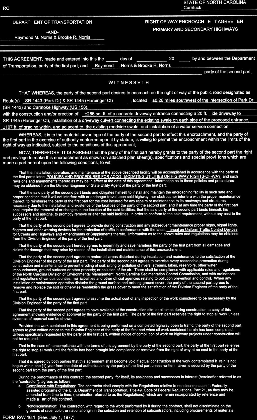
SINCE 1959 SITE NARRATIVE Major Site Plan Application Lot 18 Harbinger Park Powells Point, Currituck County, North Carolina Prepared For: Richard M No
|
|
|
- Grant Lambert
- 5 years ago
- Views:
Transcription
1
2
3


4

5


6
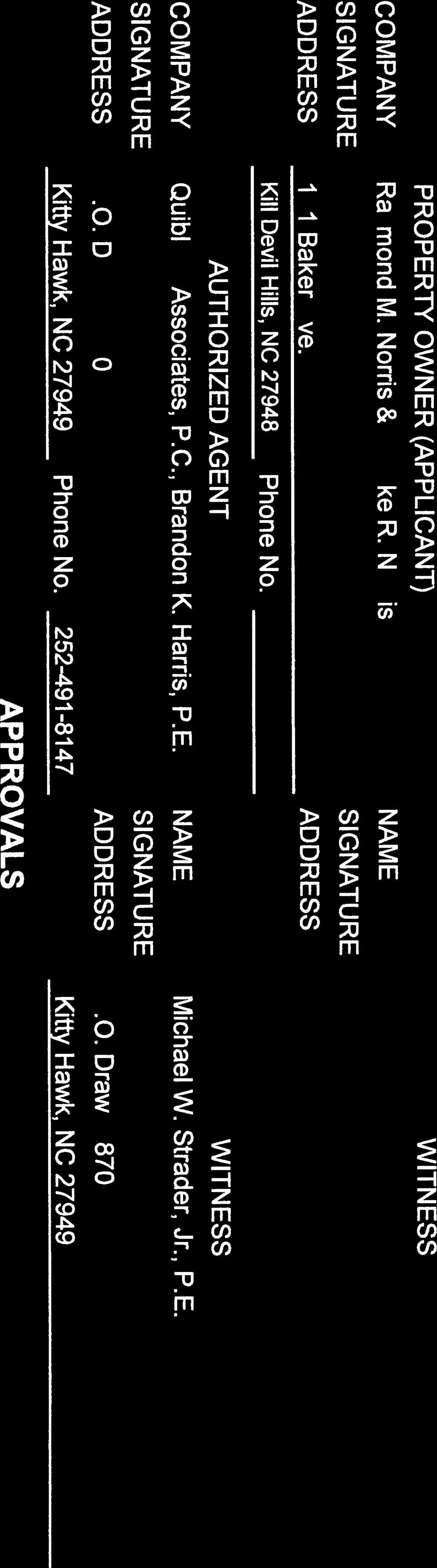
 491-8147 FAX (252) 491-8146 Quible.")
7 SINCE 1959 SITE NARRATIVE Major Site Plan Application Lot 18 Harbinger Park Powells Point, Currituck County, North Carolina Prepared For: Richard M Norris & Brooke R Norris 101 Baker Ave. Kill Devil Hills, NC Prepared By: Quible & Associates, P.C. Engineering Environmental Sciences Surveying Planning PO Drawer 870 Kitty Hawk, North Carolina (252) FAX (252) Quible.com Project Number P18029 June 28, 2018
 Appendix C Hydraulic Conductivity Memo, dated June 27, 2018 Appendix D")
8 Table of Contents Overview... 2 Access... 2 Parking... 2 Stormwater Management Plan... 2 Utilities... 4 Buffers and Site Landscaping... 4 Appendices Appendix A Drainage Area Exhibits Appendix B Stormwater Calculations and Hydrographs (Hydraflow Model Report) Appendix C Hydraulic Conductivity Memo, dated June 27, 2018 Appendix D NRCS Soils Report P.O. Drawer 870 Kitty Hawk, NC Telephone (252) Fax (252)
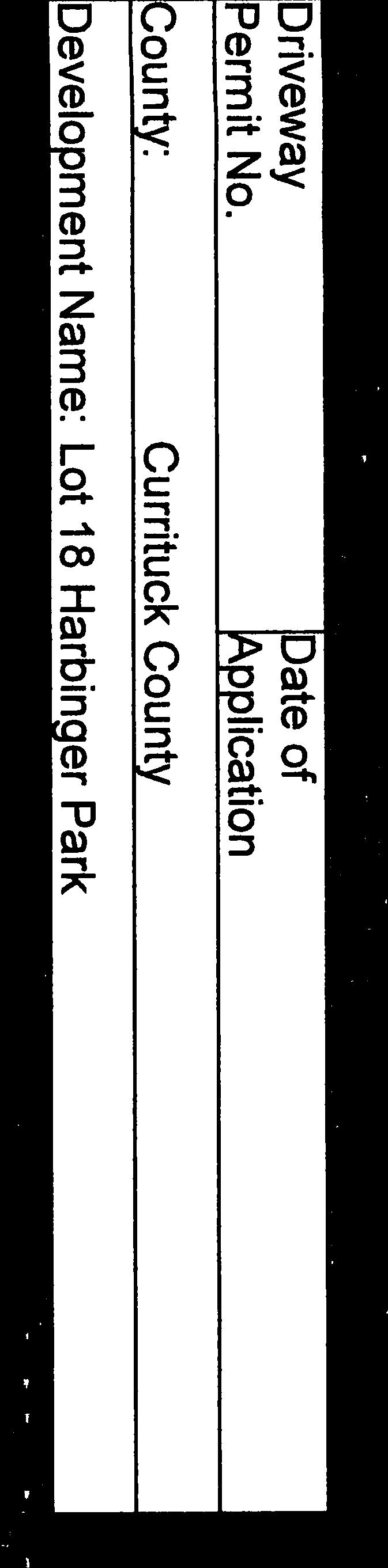
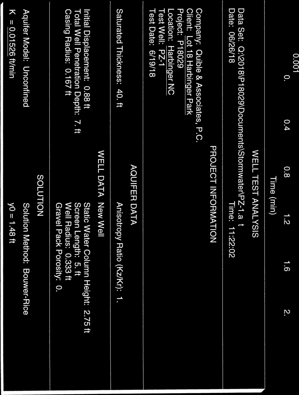
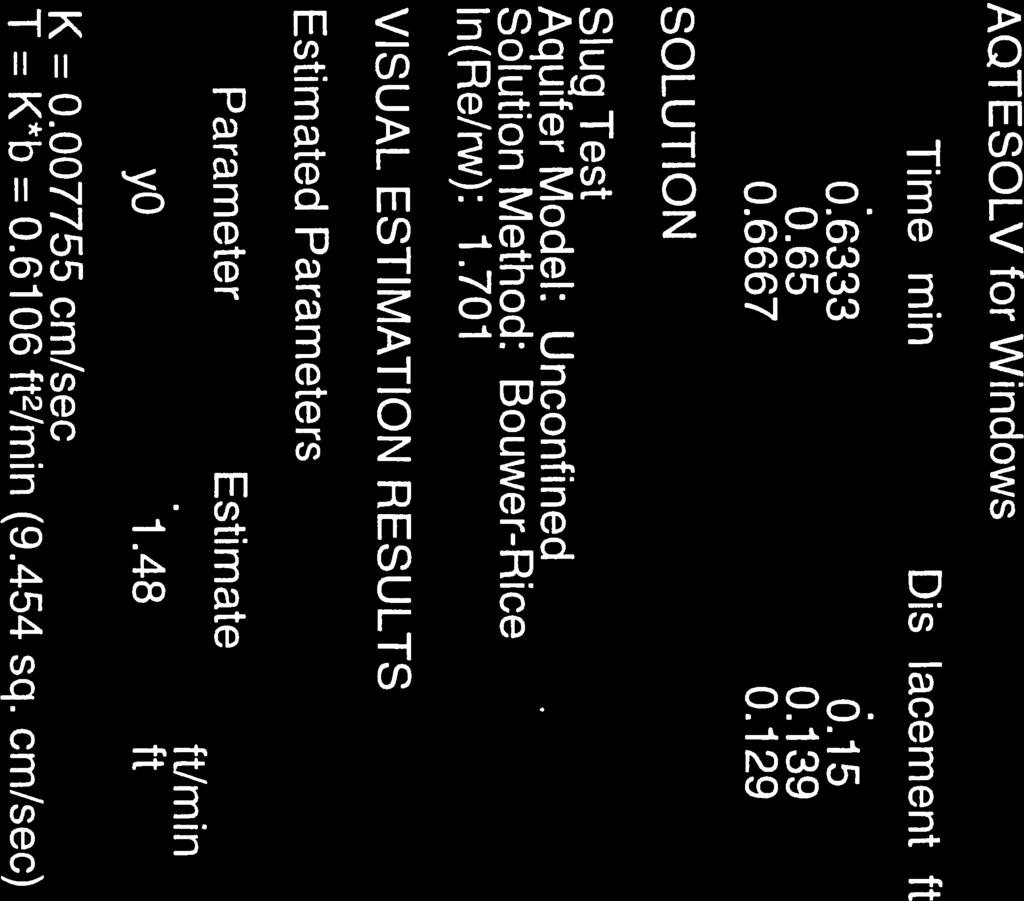
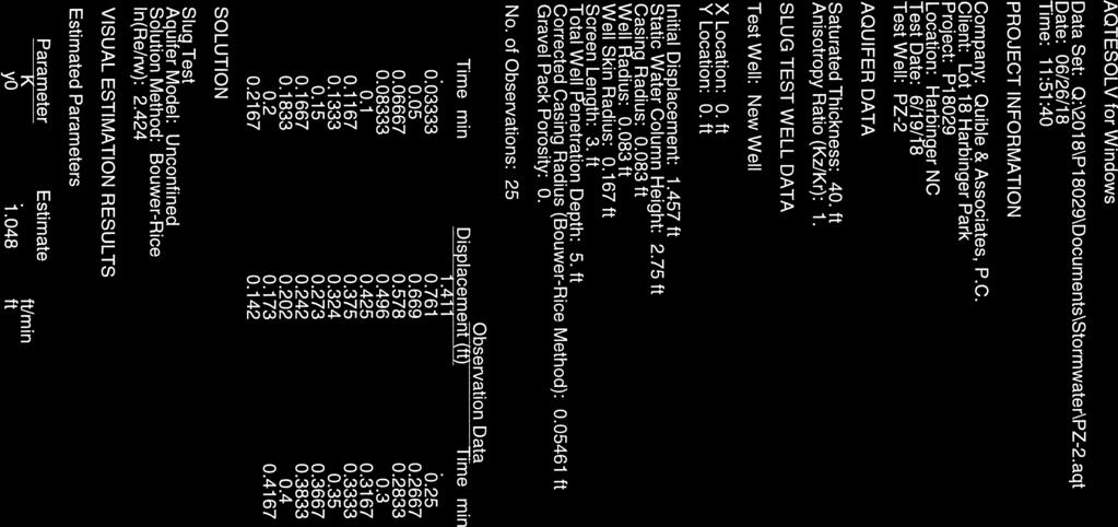
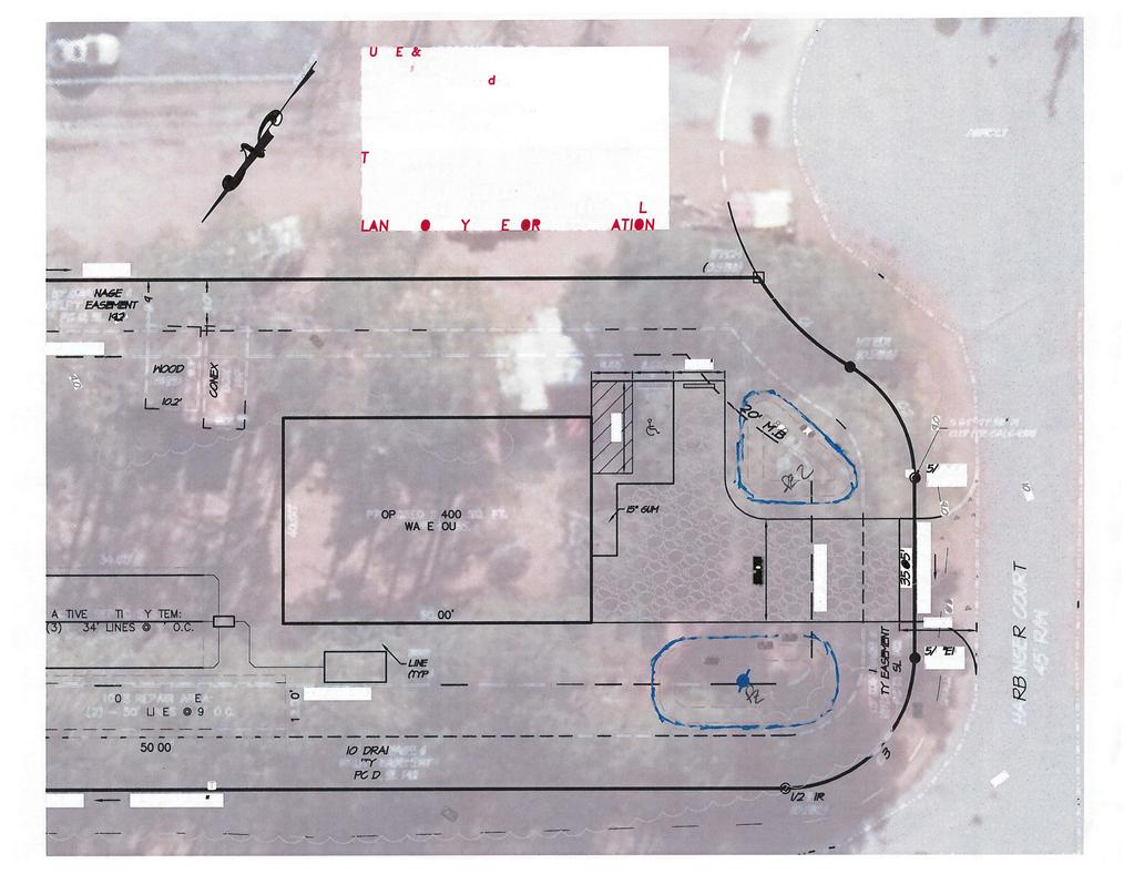
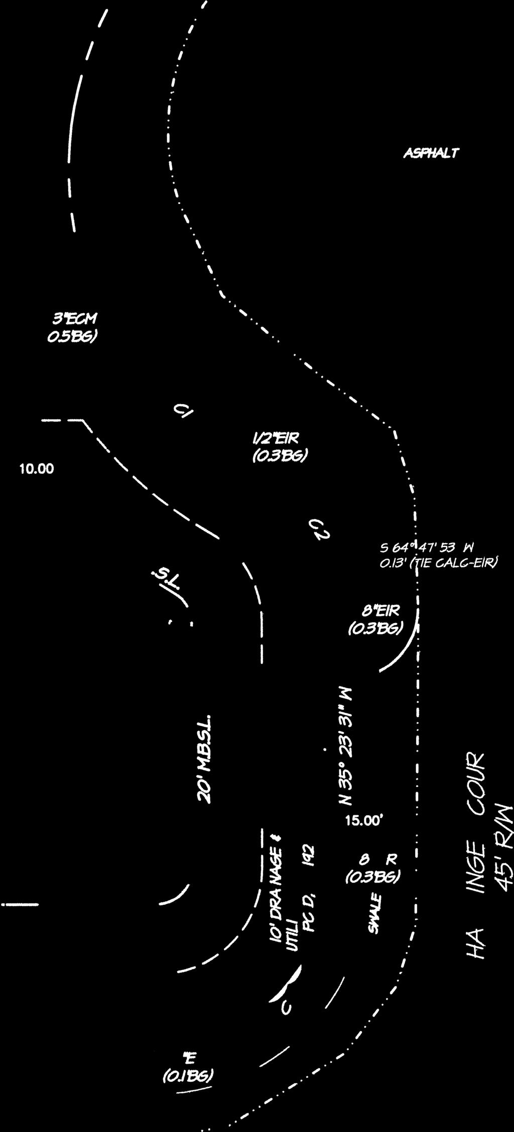
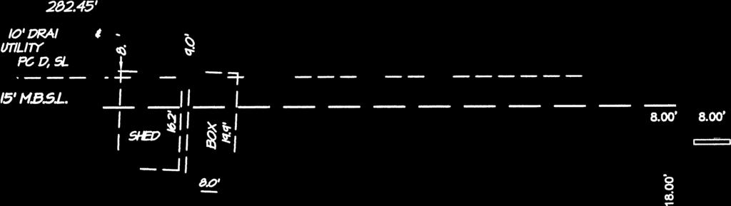
9 Lot 18 Harbinger Park June 28, 2018 Site Narrative OVERVIEW ACCESS PARKING The subject property is located at 109 Harbinger Ct. in Powells Point, Currituck County, North Carolina. The property is zoned Light Industrial (LI) and a portion of the property currently has an existing use related to vehicular storage. The site development proposes the construction of a 2,400 sq. ft. warehouse, and associated utilities, gravel drive with gravel and concrete parking area, concrete driveway apron, and associated stormwater control measures. The proposed warehouse will be accessed from Harbinger Court, with a right of way belonging to NCDOT. An NCDOT Encroachment Agreement, and an NCDOT Street and Driveway Access Permit are being applied for, and copies of the applications are included with the major site plan submittal. A concrete driveway apron is being proposed for a distance of 15 feet from the edge of pavement, and a 20 feet wide gravel driveway is proposed to access the building. Site triangles (20 ft. by 20 ft.) are demonstrated on the site plan at the proposed access. Based on a warehouse use (1 parking space per 2,500 sq. ft.), the proposed 2,400 sq. ft. warehouse will require one parking space. Two parking spaces are proposed, one 10 ft. by 18 ft. gravel parking space, and one 8 ft. by 18 ft. van accessible concrete ADA parking space with associated 8 ft. by 18 ft. loading zone. STORMWATER MANAGEMENT PLAN Stormwater runoff from the proposed development shall be managed through two infiltration basins located toward the front of the site. Each infiltration basin has a bottom elevation of 8.0 feet, and an overflow elevation of 9.5 feet. Based on the results of the slug test, summarized in the hydraulic conductivity memo, dated June 27, 2018 (see Appendix C), saturated hydraulic conductivity values can be expected at inches per hour, and 8.42 inches per hour. The depth to seasonal high water table was observed at approximately 42 inches below ground surface. Roof drains shall be incorporated to direct runoff from the proposed warehouse to the proposed infiltration basins. Hydraflow Hydrographs Extension for AutoCAD Civil 3D 2018 by Autodesk, Inc. v12 was used in calculating stormwater runoff hydrographs for pre-development and postdevelopment drainage areas, and for routing the post-development hydrographs through the proposed infiltration basins, and this report is included in Appendix B. Pre-Development: The pre-development drainage area was delineated and is included in the Pre- Developed Drainage Area Exhibit (Appendix A). The Pre-Developed Drainage Area (DA-1) was calculated to have an area of 37,189 sq. ft. (0.85 acres). In determining the P.O. Drawer 870 Kitty Hawk, NC Telephone (252) Fax (252)
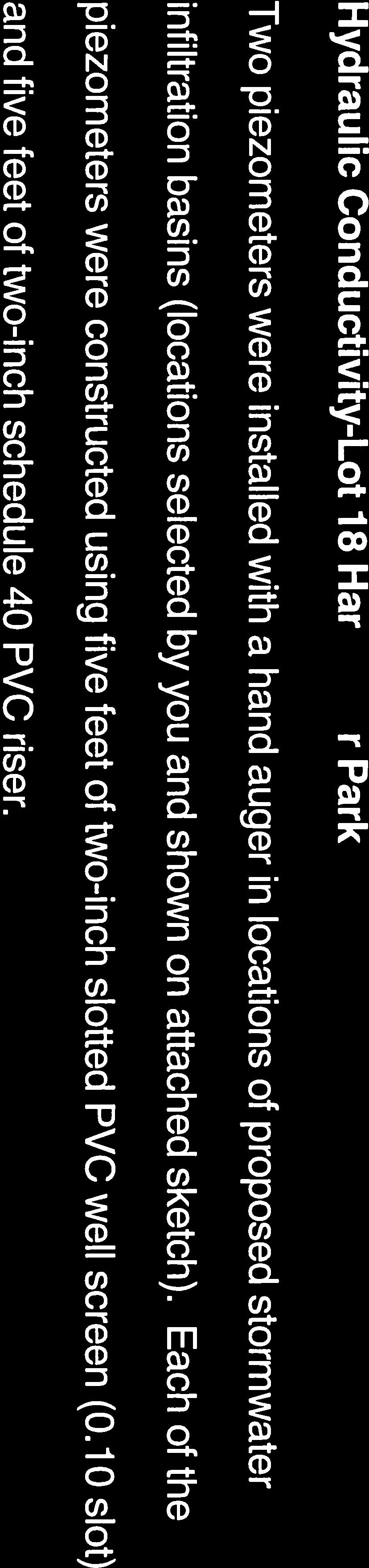
10 Lot 18 Harbinger Park June 28, 2018 Site Narrative rational method runoff hydrograph for DA-1, a runoff coefficient of 0.20 for a wooded condition was used. The 2-year Pre-Developed peak flow in a wooded condition for DA- 1 was calculated to be cubic feet per second (cfs). Post Development: The post-development drainage areas were delineated and are included in the Post- Developed Drainage Area Exhibit (Appendix A). DA-1A and DA-1B include impervious areas from the proposed development, while DA-1C includes the residual drainage area from the pre-developed DA-1. DA-1A has an area of 3,868 sq. ft. (0.089 acres) and a weighted runoff coefficient of DA-1B has an area of 3,823 sq. ft. (0.088 acres) and a weighted runoff coefficient of The residual drainage area, DA-1C has an area of 29,498 sq. ft. (0.68 acres), and the runoff coefficient for DA-1C was maintained at the determined pre-developed, wooded condition of 0.20, because the proposed improvements are located within DA-1A and DA-1B, with the exception of the driveway entrance. Prior to routing through the infiltration basins, the 5-year Post-Developed peak flow for DA-1A was calculated to be cfs, and for DA-1B was calculated to be cfs. Routing: The 5-year post-developed hydrographs for DA-1A and DA-1B were routed through their respective infiltration basins, with an infiltration rate set at 8 inches per hour, and for both drainage areas, the peak discharge from each infiltration basin was 0.0 cfs. In the infiltration basin serving DA-1A, the maximum water surface elevation during the 5-year storm was 8.71 feet. In the infiltration basin serving DA-1B, the maximum water surface elevation during the 5-year storm was 8.33 feet. Conclusion: The proposed infiltration basins serving post-developed drainage areas DA-1A and DA- 1B are capable of storing and infiltrating the entire 5-year post-developed storm runoff volume, without discharging the runoff over the overflow weir. The peak runoff in pre and post development may be summarized as follows: Peak Runoff, cfs Pre-Development: DA-1 2-YR Wooded Total = Post-Development: DA-1A 5-YR DA-1B 5-YR DA-1C 2-YR Wooded Total = The comparison above illustrates the results of a stormwater management plan that routes the 5-year post-developed storm runoff back to a value less than the 2-year predeveloped wooded conditions for the project area. P.O. Drawer 870 Kitty Hawk, NC Telephone (252) Fax (252)
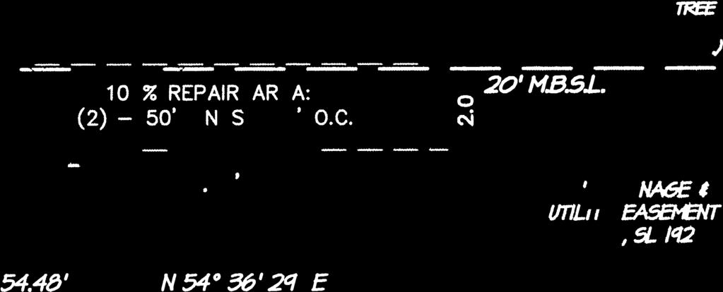
11 Lot 18 Harbinger Park June 28, 2018 Site Narrative UTILITIES The site is proposed to receive water service by way of connecting to the Currituck County water main along Park Drive. The proposed water service and associated tap shall be installed per Currituck County standard water specifications and details. Wastewater is proposed to be managed on-site by way of a conventional trench septic system with a 100% repair area. The design flow of the wastewater system was determined based on a factory use at 25 gallons per day per employee, with 4 employees assumed, for a total flow of 100 gallons per day; however, a minimum design flow of 240 gallons per day was used as the design flow. An Albemarle Regional Health Services Site Evaluation/Improvement Permit for Wastewater System is being applied for, and a copy of the application is included with the major site plan submittal. BUFFERS AND SITE LANDSCAPING The surrounding adjoining properties are also zoned Light Industrial (LI), and therefore landscape buffers along property lines are not required. Building façade landscaping, and vehicular use landscaping have been provided on the site plan. Due to the nature of the existing trees on-site, the required 2 ACI canopy tree is proposed to be designated as an existing tree on-site by the Contractor. P.O. Drawer 870 Kitty Hawk, NC Telephone (252) Fax (252)
12 Appendices
13 Appendix A Drainage Area Exhibits
14
15
16 Appendix B Stormwater Calculations and Hydrographs (Hydraflow Model Report)
17 Hydraflow Table of Contents P18029-Lot18HarbingerPark.gpw Hydraflow Hydrographs Extension for AutoCAD Civil 3D 2018 by Autodesk, Inc. v12 Wednesday, 06 / 27 / 2018 Watershed Model Schematic... 1 Hydrograph Return Period Recap Year Summary Report... 3 Hydrograph Reports... 4 Hydrograph No. 1, Rational, DA-1C Post-Dev Wooded... 4 TR-55 Tc Worksheet... 5 Hydrograph No. 2, Rational, DA-1A Post-Dev... 6 Hydrograph No. 3, Rational, DA-1B Post-Dev... 7 Hydrograph No. 4, Reservoir, DA-1A to Inf. Basin A... 8 Pond Report - Inf. Basin A... 9 Hydrograph No. 5, Rational, DA-1 Pre-Dev Wooded TR-55 Tc Worksheet Hydrograph No. 6, Reservoir, DA-1B to Inf. Basin B Pond Report - Inf. Basin B Year Summary Report Hydrograph Reports Hydrograph No. 1, Rational, DA-1C Post-Dev Wooded Hydrograph No. 2, Rational, DA-1A Post-Dev Hydrograph No. 3, Rational, DA-1B Post-Dev Hydrograph No. 4, Reservoir, DA-1A to Inf. Basin A Hydrograph No. 5, Rational, DA-1 Pre-Dev Wooded Hydrograph No. 6, Reservoir, DA-1B to Inf. Basin B IDF Report... 21
18 Watershed Model Schematic Hydraflow Hydrographs Extension for AutoCAD Civil 3D 2018 by Autodesk, Inc. v DA-1C Post-Dev Wooded 2 - DA-1A Post-Dev 3 - DA-1B Post-Dev 5 - DA-1 Pre-Dev Wooded 4 - DA-1A to Inf. Basin A 6 - DA-1B to Inf. Basin B Legend Hyd. Origin Description 1 Rational DA-1C Post-Dev Wooded 2 Rational DA-1A Post-Dev 3 Rational DA-1B Post-Dev 4 Reservoir DA-1A to Inf. Basin A 5 Rational DA-1 Pre-Dev Wooded 6 Reservoir DA-1B to Inf. Basin B Project: P18029-Lot18HarbingerPark.gpw Wednesday, 06 / 27 / 2018
19 Hydrograph Return Period Recap Hydraflow Hydrographs Extension for AutoCAD Civil 3D 2018 by Autodesk, Inc. v12 Hyd. Hydrograph Inflow Peak Outflow (cfs) Hydrograph No. type hyd(s) Description (origin) 1-yr 2-yr 3-yr 5-yr 10-yr 25-yr 50-yr 100-yr 2 1 Rational DA-1C Post-Dev Wooded 2 Rational DA-1A Post-Dev 3 Rational DA-1B Post-Dev 4 Reservoir DA-1A to Inf. Basin A 5 Rational DA-1 Pre-Dev Wooded 6 Reservoir DA-1B to Inf. Basin B Proj. file: P18029-Lot18HarbingerPark.gpw Wednesday, 06 / 27 / 2018
20 Hydrograph Summary Report Hydraflow Hydrographs Extension for AutoCAD Civil 3D 2018 by Autodesk, Inc. v12 3 Hyd. Hydrograph Peak Time Time to Hyd. Inflow Maximum Total Hydrograph No. type flow interval Peak volume hyd(s) elevation strge used Description (origin) (cfs) (min) (min) (cuft) (ft) (cuft) 1 Rational DA-1C Post-Dev Wooded 2 Rational DA-1A Post-Dev 3 Rational DA-1B Post-Dev 4 Reservoir DA-1A to Inf. Basin A 5 Rational DA-1 Pre-Dev Wooded 6 Reservoir DA-1B to Inf. Basin B P18029-Lot18HarbingerPark.gpw Return Period: 2 Year Wednesday, 06 / 27 / 2018
21 Hydrograph Report 4 Hydraflow Hydrographs Extension for AutoCAD Civil 3D 2018 by Autodesk, Inc. v12 Wednesday, 06 / 27 / 2018 Hyd. No. 1 DA-1C Post-Dev Wooded Hydrograph type = Rational Peak discharge = cfs Storm frequency = 2 yrs Time to peak = 0.57 hrs Time interval = 1 min Hyd. volume = 749 cuft Drainage area = ac Runoff coeff. = 0.2 Intensity = in/hr Tc by TR55 = min IDF Curve = P18029-Lot18HarbingerPark.IDF Asc/Rec limb fact = 1/1 Q (cfs) DA-1C Post-Dev Wooded Hyd. No Year Q (cfs) Hyd No. 1 Time (hrs)
22 TR55 Tc Worksheet 5 Hydraflow Hydrographs Extension for AutoCAD Civil 3D 2018 by Autodesk, Inc. v12 Hyd. No. 1 DA-1C Post-Dev Wooded Description A B C Totals Sheet Flow Manning's n-value = Flow length (ft) = Two-year 24-hr precip. (in) = Land slope (%) = Travel Time (min) = = Shallow Concentrated Flow Flow length (ft) = Watercourse slope (%) = Surface description = Unpaved Paved Paved Average velocity (ft/s) = Travel Time (min) = = 0.00 Channel Flow X sectional flow area (sqft) = Wetted perimeter (ft) = Channel slope (%) = Manning's n-value = Velocity (ft/s) = Flow length (ft) ({0}) Travel Time (min) = = 0.00 Total Travel Time, Tc min
23 Hydrograph Report 6 Hydraflow Hydrographs Extension for AutoCAD Civil 3D 2018 by Autodesk, Inc. v12 Wednesday, 06 / 27 / 2018 Hyd. No. 2 DA-1A Post-Dev Hydrograph type = Rational Peak discharge = cfs Storm frequency = 2 yrs Time to peak = 0.08 hrs Time interval = 1 min Hyd. volume = 116 cuft Drainage area = ac Runoff coeff. = 0.69 Intensity = in/hr Tc by User = 5.00 min IDF Curve = P18029-Lot18HarbingerPark.IDF Asc/Rec limb fact = 1/1 Q (cfs) DA-1A Post-Dev Hyd. No Year Q (cfs) Hyd No. 2 Time (hrs)
24 Hydrograph Report 7 Hydraflow Hydrographs Extension for AutoCAD Civil 3D 2018 by Autodesk, Inc. v12 Wednesday, 06 / 27 / 2018 Hyd. No. 3 DA-1B Post-Dev Hydrograph type = Rational Peak discharge = cfs Storm frequency = 2 yrs Time to peak = 0.08 hrs Time interval = 1 min Hyd. volume = 106 cuft Drainage area = ac Runoff coeff. = 0.64 Intensity = in/hr Tc by User = 5.00 min IDF Curve = P18029-Lot18HarbingerPark.IDF Asc/Rec limb fact = 1/1 Q (cfs) DA-1B Post-Dev Hyd. No Year Q (cfs) Hyd No. 3 Time (hrs)
25 Hydrograph Report 8 Hydraflow Hydrographs Extension for AutoCAD Civil 3D 2018 by Autodesk, Inc. v12 Wednesday, 06 / 27 / 2018 Hyd. No. 4 DA-1A to Inf. Basin A Hydrograph type = Reservoir Peak discharge = cfs Storm frequency = 2 yrs Time to peak = 0.25 hrs Time interval = 1 min Hyd. volume = 0 cuft Inflow hyd. No. = 2 - DA-1A Post-Dev Max. Elevation = 8.62 ft Reservoir name = Inf. Basin A Max. Storage = 107 cuft Storage Indication method used. Exfiltration extracted from Outflow. Q (cfs) DA-1A to Inf. Basin A Hyd. No Year Q (cfs) Time (hrs) Hyd No. 4 Hyd No. 2 Total storage used = 107 cuft
26 Pond Report 9 Hydraflow Hydrographs Extension for AutoCAD Civil 3D 2018 by Autodesk, Inc. v12 Wednesday, 06 / 27 / 2018 Pond No. 1 - Inf. Basin A Pond Data Contours -User-defined contour areas. Conic method used for volume calculation. Begining Elevation = 8.00 ft Stage / Storage Table Stage (ft) Elevation (ft) Contour area (sqft) Incr. Storage (cuft) Total storage (cuft) Culvert / Orifice Structures Weir Structures [A] [B] [C] [PrfRsr] [A] [B] [C] [D] Rise (in) Inactive Inactive Inactive Inactive Span (in) = No. Barrels = Invert El. (ft) = Length (ft) = Slope (%) = n/a N-Value = n/a Orifice Coeff. = Multi-Stage = n/a No No No Crest Len (ft) = Inactive Inactive Inactive Crest El. (ft) = Weir Coeff. = Weir Type = Broad Multi-Stage = No No No No Exfil.(in/hr) = (by Contour) TW Elev. (ft) = 0.00 Note: Culvert/Orifice outflows are analyzed under inlet (ic) and outlet (oc) control. Weir risers checked for orifice conditions (ic) and submergence (s). Stage (ft) Stage / Discharge Elev (ft) Total Q Discharge (cfs)
27 Hydrograph Report 10 Hydraflow Hydrographs Extension for AutoCAD Civil 3D 2018 by Autodesk, Inc. v12 Wednesday, 06 / 27 / 2018 Hyd. No. 5 DA-1 Pre-Dev Wooded Hydrograph type = Rational Peak discharge = cfs Storm frequency = 2 yrs Time to peak = 0.50 hrs Time interval = 1 min Hyd. volume = 894 cuft Drainage area = ac Runoff coeff. = 0.2 Intensity = in/hr Tc by TR55 = min IDF Curve = P18029-Lot18HarbingerPark.IDF Asc/Rec limb fact = 1/1 Q (cfs) DA-1 Pre-Dev Wooded Hyd. No Year Q (cfs) Hyd No. 5 Time (hrs)
28 TR55 Tc Worksheet 11 Hydraflow Hydrographs Extension for AutoCAD Civil 3D 2018 by Autodesk, Inc. v12 Hyd. No. 5 DA-1 Pre-Dev Wooded Description A B C Totals Sheet Flow Manning's n-value = Flow length (ft) = Two-year 24-hr precip. (in) = Land slope (%) = Travel Time (min) = = Shallow Concentrated Flow Flow length (ft) = Watercourse slope (%) = Surface description = Unpaved Paved Paved Average velocity (ft/s) = Travel Time (min) = = 2.41 Channel Flow X sectional flow area (sqft) = Wetted perimeter (ft) = Channel slope (%) = Manning's n-value = Velocity (ft/s) = Flow length (ft) ({0}) Travel Time (min) = = 0.00 Total Travel Time, Tc min
29 Hydrograph Report 12 Hydraflow Hydrographs Extension for AutoCAD Civil 3D 2018 by Autodesk, Inc. v12 Wednesday, 06 / 27 / 2018 Hyd. No. 6 DA-1B to Inf. Basin B Hydrograph type = Reservoir Peak discharge = cfs Storm frequency = 2 yrs Time to peak = 0.62 hrs Time interval = 1 min Hyd. volume = 0 cuft Inflow hyd. No. = 3 - DA-1B Post-Dev Max. Elevation = 8.29 ft Reservoir name = Inf. Basin B Max. Storage = 99 cuft Storage Indication method used. Exfiltration extracted from Outflow. Q (cfs) DA-1B to Inf. Basin B Hyd. No Year Q (cfs) Time (hrs) Hyd No. 6 Hyd No. 3 Total storage used = 99 cuft
30 Pond Report 13 Hydraflow Hydrographs Extension for AutoCAD Civil 3D 2018 by Autodesk, Inc. v12 Wednesday, 06 / 27 / 2018 Pond No. 2 - Inf. Basin B Pond Data Contours -User-defined contour areas. Conic method used for volume calculation. Begining Elevation = 8.00 ft Stage / Storage Table Stage (ft) Elevation (ft) Contour area (sqft) Incr. Storage (cuft) Total storage (cuft) Culvert / Orifice Structures Weir Structures [A] [B] [C] [PrfRsr] [A] [B] [C] [D] Rise (in) Inactive Inactive Inactive Inactive Span (in) = No. Barrels = Invert El. (ft) = Length (ft) = Slope (%) = n/a N-Value = n/a Orifice Coeff. = Multi-Stage = n/a No No No Crest Len (ft) = Inactive Inactive Inactive Crest El. (ft) = Weir Coeff. = Weir Type = Broad Multi-Stage = No No No No Exfil.(in/hr) = (by Contour) TW Elev. (ft) = 0.00 Note: Culvert/Orifice outflows are analyzed under inlet (ic) and outlet (oc) control. Weir risers checked for orifice conditions (ic) and submergence (s). Stage (ft) Stage / Discharge Elev (ft) Total Q Discharge (cfs)
31 Hydrograph Summary Report Hydraflow Hydrographs Extension for AutoCAD Civil 3D 2018 by Autodesk, Inc. v12 14 Hyd. Hydrograph Peak Time Time to Hyd. Inflow Maximum Total Hydrograph No. type flow interval Peak volume hyd(s) elevation strge used Description (origin) (cfs) (min) (min) (cuft) (ft) (cuft) 1 Rational DA-1C Post-Dev Wooded 2 Rational DA-1A Post-Dev 3 Rational DA-1B Post-Dev 4 Reservoir DA-1A to Inf. Basin A 5 Rational , DA-1 Pre-Dev Wooded 6 Reservoir DA-1B to Inf. Basin B P18029-Lot18HarbingerPark.gpw Return Period: 5 Year Wednesday, 06 / 27 / 2018
32 Hydrograph Report 15 Hydraflow Hydrographs Extension for AutoCAD Civil 3D 2018 by Autodesk, Inc. v12 Wednesday, 06 / 27 / 2018 Hyd. No. 1 DA-1C Post-Dev Wooded Hydrograph type = Rational Peak discharge = cfs Storm frequency = 5 yrs Time to peak = 0.57 hrs Time interval = 1 min Hyd. volume = 886 cuft Drainage area = ac Runoff coeff. = 0.2 Intensity = in/hr Tc by TR55 = min IDF Curve = P18029-Lot18HarbingerPark.IDF Asc/Rec limb fact = 1/1 Q (cfs) DA-1C Post-Dev Wooded Hyd. No Year Q (cfs) Hyd No. 1 Time (hrs)
33 Hydrograph Report 16 Hydraflow Hydrographs Extension for AutoCAD Civil 3D 2018 by Autodesk, Inc. v12 Wednesday, 06 / 27 / 2018 Hyd. No. 2 DA-1A Post-Dev Hydrograph type = Rational Peak discharge = cfs Storm frequency = 5 yrs Time to peak = 0.08 hrs Time interval = 1 min Hyd. volume = 132 cuft Drainage area = ac Runoff coeff. = 0.69 Intensity = in/hr Tc by User = 5.00 min IDF Curve = P18029-Lot18HarbingerPark.IDF Asc/Rec limb fact = 1/1 Q (cfs) DA-1A Post-Dev Hyd. No Year Q (cfs) Hyd No. 2 Time (hrs)
34 Hydrograph Report 17 Hydraflow Hydrographs Extension for AutoCAD Civil 3D 2018 by Autodesk, Inc. v12 Wednesday, 06 / 27 / 2018 Hyd. No. 3 DA-1B Post-Dev Hydrograph type = Rational Peak discharge = cfs Storm frequency = 5 yrs Time to peak = 0.08 hrs Time interval = 1 min Hyd. volume = 121 cuft Drainage area = ac Runoff coeff. = 0.64 Intensity = in/hr Tc by User = 5.00 min IDF Curve = P18029-Lot18HarbingerPark.IDF Asc/Rec limb fact = 1/1 Q (cfs) DA-1B Post-Dev Hyd. No Year Q (cfs) Hyd No. 3 Time (hrs)
35 Hydrograph Report 18 Hydraflow Hydrographs Extension for AutoCAD Civil 3D 2018 by Autodesk, Inc. v12 Wednesday, 06 / 27 / 2018 Hyd. No. 4 DA-1A to Inf. Basin A Hydrograph type = Reservoir Peak discharge = cfs Storm frequency = 5 yrs Time to peak = 0.30 hrs Time interval = 1 min Hyd. volume = 0 cuft Inflow hyd. No. = 2 - DA-1A Post-Dev Max. Elevation = 8.71 ft Reservoir name = Inf. Basin A Max. Storage = 122 cuft Storage Indication method used. Exfiltration extracted from Outflow. Q (cfs) DA-1A to Inf. Basin A Hyd. No Year Q (cfs) Time (hrs) Hyd No. 4 Hyd No. 2 Total storage used = 122 cuft
36 Hydrograph Report 19 Hydraflow Hydrographs Extension for AutoCAD Civil 3D 2018 by Autodesk, Inc. v12 Wednesday, 06 / 27 / 2018 Hyd. No. 5 DA-1 Pre-Dev Wooded Hydrograph type = Rational Peak discharge = cfs Storm frequency = 5 yrs Time to peak = 0.50 hrs Time interval = 1 min Hyd. volume = 1,053 cuft Drainage area = ac Runoff coeff. = 0.2 Intensity = in/hr Tc by TR55 = min IDF Curve = P18029-Lot18HarbingerPark.IDF Asc/Rec limb fact = 1/1 Q (cfs) DA-1 Pre-Dev Wooded Hyd. No Year Q (cfs) Hyd No. 5 Time (hrs)
37 Hydrograph Report 20 Hydraflow Hydrographs Extension for AutoCAD Civil 3D 2018 by Autodesk, Inc. v12 Wednesday, 06 / 27 / 2018 Hyd. No. 6 DA-1B to Inf. Basin B Hydrograph type = Reservoir Peak discharge = cfs Storm frequency = 5 yrs Time to peak = 0.13 hrs Time interval = 1 min Hyd. volume = 0 cuft Inflow hyd. No. = 3 - DA-1B Post-Dev Max. Elevation = 8.33 ft Reservoir name = Inf. Basin B Max. Storage = 113 cuft Storage Indication method used. Exfiltration extracted from Outflow. Q (cfs) DA-1B to Inf. Basin B Hyd. No Year Q (cfs) Time (hrs) Hyd No. 6 Hyd No. 3 Total storage used = 113 cuft
38 Hydraflow Rainfall Report 21 Hydraflow Hydrographs Extension for AutoCAD Civil 3D 2018 by Autodesk, Inc. v12 Wednesday, 06 / 27 / 2018 Return Intensity-Duration-Frequency Equation Coefficients (FHA) Period (Yrs) B D E (N/A) File name: P18029-Lot18HarbingerPark.IDF Intensity = B / (Tc + D)^E Return Intensity Values (in/hr) Period (Yrs) 5 min Tc = time in minutes. Values may exceed 60. Precip. file name: Q:\2018\P18029\Documents\Hydraflow\P18029-Lot18HarbingerPark.pcp Rainfall Precipitation Table (in) Storm Distribution 1-yr 2-yr 3-yr 5-yr 10-yr 25-yr 50-yr 100-yr SCS 24-hour SCS 6-Hr Huff-1st Huff-2nd Huff-3rd Huff-4th Huff-Indy Custom
39 Appendix C Hydraulic Conductivity Memo, dated June 27, 2018


40


41
42


43


44


45

46


47
48 Appendix D NRCS Soils Report


49 United States Department of Agriculture Natural Resources Conservation Service A product of the National Cooperative Soil Survey, a joint effort of the United States Department of Agriculture and other Federal agencies, State agencies including the Agricultural Experiment Stations, and local participants Custom Soil Resource Report for Currituck County, North Carolina June 11, 2018
50 Preface Soil surveys contain information that affects land use planning in survey areas. They highlight soil limitations that affect various land uses and provide information about the properties of the soils in the survey areas. Soil surveys are designed for many different users, including farmers, ranchers, foresters, agronomists, urban planners, community officials, engineers, developers, builders, and home buyers. Also, conservationists, teachers, students, and specialists in recreation, waste disposal, and pollution control can use the surveys to help them understand, protect, or enhance the environment. Various land use regulations of Federal, State, and local governments may impose special restrictions on land use or land treatment. Soil surveys identify soil properties that are used in making various land use or land treatment decisions. The information is intended to help the land users identify and reduce the effects of soil limitations on various land uses. The landowner or user is responsible for identifying and complying with existing laws and regulations. Although soil survey information can be used for general farm, local, and wider area planning, onsite investigation is needed to supplement this information in some cases. Examples include soil quality assessments ( portal/nrcs/main/soils/health/) and certain conservation and engineering applications. For more detailed information, contact your local USDA Service Center ( or your NRCS State Soil Scientist ( cid=nrcs142p2_053951). Great differences in soil properties can occur within short distances. Some soils are seasonally wet or subject to flooding. Some are too unstable to be used as a foundation for buildings or roads. Clayey or wet soils are poorly suited to use as septic tank absorption fields. A high water table makes a soil poorly suited to basements or underground installations. The National Cooperative Soil Survey is a joint effort of the United States Department of Agriculture and other Federal agencies, State agencies including the Agricultural Experiment Stations, and local agencies. The Natural Resources Conservation Service (NRCS) has leadership for the Federal part of the National Cooperative Soil Survey. Information about soils is updated periodically. Updated information is available through the NRCS Web Soil Survey, the site for official soil survey information. The U.S. Department of Agriculture (USDA) prohibits discrimination in all its programs and activities on the basis of race, color, national origin, age, disability, and where applicable, sex, marital status, familial status, parental status, religion, sexual orientation, genetic information, political beliefs, reprisal, or because all or a part of an individual's income is derived from any public assistance program. (Not all prohibited bases apply to all programs.) Persons with disabilities who require 2
51 alternative means for communication of program information (Braille, large print, audiotape, etc.) should contact USDA's TARGET Center at (202) (voice and TDD). To file a complaint of discrimination, write to USDA, Director, Office of Civil Rights, 1400 Independence Avenue, S.W., Washington, D.C or call (800) (voice) or (202) (TDD). USDA is an equal opportunity provider and employer. 3
52 Contents Preface... 2 Soil Map... 5 Soil Map...6 Legend...7 Map Unit Legend... 8 Map Unit Descriptions... 8 Currituck County, North Carolina CnA Conetoe loamy sand, 0 to 3 percent slopes Mu Munden loamy sand...11 References
53 Soil Map The soil map section includes the soil map for the defined area of interest, a list of soil map units on the map and extent of each map unit, and cartographic symbols displayed on the map. Also presented are various metadata about data used to produce the map, and a description of each soil map unit. 5

54 75 49' 37'' W Custom Soil Resource Report Soil Map 75 49' 30'' W ' 26'' N 36 6' 26'' N 36 6' 23'' N Soil Map may not be valid at this scale ' 23'' N ' 37'' W N Map Scale: 1:791 if printed on A landscape (11" x 8.5") sheet. Meters Feet Map projection: Web Mercator Corner coordinates: WGS84 Edge tics: UTM Zone 18N WGS ' 30'' W
55 Custom Soil Resource Report MAP LEGEND MAP INFORMATION Area of Interest (AOI) Area of Interest (AOI) Soils Soil Map Unit Polygons Soil Map Unit Lines Soil Map Unit Points Special Point Features Blowout Borrow Pit Clay Spot Closed Depression Gravel Pit Gravelly Spot Landfill Lava Flow Marsh or swamp Mine or Quarry Miscellaneous Water Perennial Water Rock Outcrop Saline Spot Sandy Spot Severely Eroded Spot Spoil Area Stony Spot Very Stony Spot Wet Spot Other Special Line Features Water Features Streams and Canals Transportation Rails Interstate Highways US Routes Major Roads Local Roads Background Aerial Photography The soil surveys that comprise your AOI were mapped at 1:20,000. Warning: Soil Map may not be valid at this scale. Enlargement of maps beyond the scale of mapping can cause misunderstanding of the detail of mapping and accuracy of soil line placement. The maps do not show the small areas of contrasting soils that could have been shown at a more detailed scale. Please rely on the bar scale on each map sheet for map measurements. Source of Map: Natural Resources Conservation Service Web Soil Survey URL: Coordinate System: Web Mercator (EPSG:3857) Maps from the Web Soil Survey are based on the Web Mercator projection, which preserves direction and shape but distorts distance and area. A projection that preserves area, such as the Albers equal-area conic projection, should be used if more accurate calculations of distance or area are required. This product is generated from the USDA-NRCS certified data as of the version date(s) listed below. Soil Survey Area: Currituck County, North Carolina Survey Area Data: Version 16, Sep 26, 2017 Soil map units are labeled (as space allows) for map scales 1:50,000 or larger. Sinkhole Slide or Slip Date(s) aerial images were photographed: 19, 2017 Dec 31, 2009 Oct Sodic Spot The orthophoto or other base map on which the soil lines were compiled and digitized probably differs from the background imagery displayed on these maps. As a result, some minor shifting of map unit boundaries may be evident. 7
56 Custom Soil Resource Report Map Unit Legend Map Unit Symbol Map Unit Name Acres in AOI Percent of AOI CnA Conetoe loamy sand, 0 to 3 percent slopes % Mu Munden loamy sand % Totals for Area of Interest % Map Unit Descriptions The map units delineated on the detailed soil maps in a soil survey represent the soils or miscellaneous areas in the survey area. The map unit descriptions, along with the maps, can be used to determine the composition and properties of a unit. A map unit delineation on a soil map represents an area dominated by one or more major kinds of soil or miscellaneous areas. A map unit is identified and named according to the taxonomic classification of the dominant soils. Within a taxonomic class there are precisely defined limits for the properties of the soils. On the landscape, however, the soils are natural phenomena, and they have the characteristic variability of all natural phenomena. Thus, the range of some observed properties may extend beyond the limits defined for a taxonomic class. Areas of soils of a single taxonomic class rarely, if ever, can be mapped without including areas of other taxonomic classes. Consequently, every map unit is made up of the soils or miscellaneous areas for which it is named and some minor components that belong to taxonomic classes other than those of the major soils. Most minor soils have properties similar to those of the dominant soil or soils in the map unit, and thus they do not affect use and management. These are called noncontrasting, or similar, components. They may or may not be mentioned in a particular map unit description. Other minor components, however, have properties and behavioral characteristics divergent enough to affect use or to require different management. These are called contrasting, or dissimilar, components. They generally are in small areas and could not be mapped separately because of the scale used. Some small areas of strongly contrasting soils or miscellaneous areas are identified by a special symbol on the maps. If included in the database for a given area, the contrasting minor components are identified in the map unit descriptions along with some characteristics of each. A few areas of minor components may not have been observed, and consequently they are not mentioned in the descriptions, especially where the pattern was so complex that it was impractical to make enough observations to identify all the soils and miscellaneous areas on the landscape. The presence of minor components in a map unit in no way diminishes the usefulness or accuracy of the data. The objective of mapping is not to delineate pure taxonomic classes but rather to separate the landscape into landforms or landform segments that have similar use and management requirements. The delineation of such segments on the map provides sufficient information for the development of resource plans. If intensive use of small areas is planned, however, 8
57 Custom Soil Resource Report onsite investigation is needed to define and locate the soils and miscellaneous areas. An identifying symbol precedes the map unit name in the map unit descriptions. Each description includes general facts about the unit and gives important soil properties and qualities. Soils that have profiles that are almost alike make up a soil series. Except for differences in texture of the surface layer, all the soils of a series have major horizons that are similar in composition, thickness, and arrangement. Soils of one series can differ in texture of the surface layer, slope, stoniness, salinity, degree of erosion, and other characteristics that affect their use. On the basis of such differences, a soil series is divided into soil phases. Most of the areas shown on the detailed soil maps are phases of soil series. The name of a soil phase commonly indicates a feature that affects use or management. For example, Alpha silt loam, 0 to 2 percent slopes, is a phase of the Alpha series. Some map units are made up of two or more major soils or miscellaneous areas. These map units are complexes, associations, or undifferentiated groups. A complex consists of two or more soils or miscellaneous areas in such an intricate pattern or in such small areas that they cannot be shown separately on the maps. The pattern and proportion of the soils or miscellaneous areas are somewhat similar in all areas. Alpha-Beta complex, 0 to 6 percent slopes, is an example. An association is made up of two or more geographically associated soils or miscellaneous areas that are shown as one unit on the maps. Because of present or anticipated uses of the map units in the survey area, it was not considered practical or necessary to map the soils or miscellaneous areas separately. The pattern and relative proportion of the soils or miscellaneous areas are somewhat similar. Alpha-Beta association, 0 to 2 percent slopes, is an example. An undifferentiated group is made up of two or more soils or miscellaneous areas that could be mapped individually but are mapped as one unit because similar interpretations can be made for use and management. The pattern and proportion of the soils or miscellaneous areas in a mapped area are not uniform. An area can be made up of only one of the major soils or miscellaneous areas, or it can be made up of all of them. Alpha and Beta soils, 0 to 2 percent slopes, is an example. Some surveys include miscellaneous areas. Such areas have little or no soil material and support little or no vegetation. Rock outcrop is an example. 9
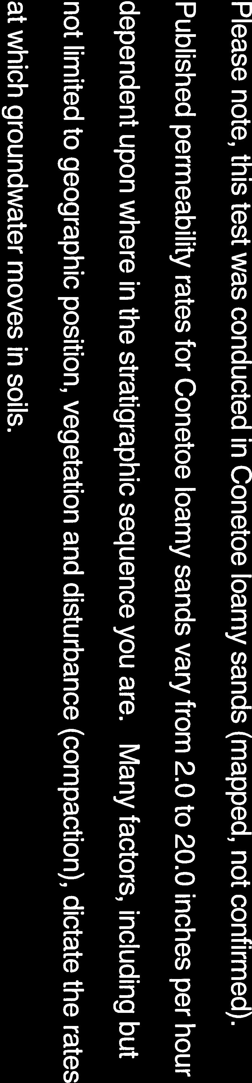
58 Custom Soil Resource Report Currituck County, North Carolina CnA Conetoe loamy sand, 0 to 3 percent slopes Map Unit Setting National map unit symbol: 3rnf Elevation: 0 to 20 feet Mean annual precipitation: 42 to 58 inches Mean annual air temperature: 61 to 64 degrees F Frost-free period: 190 to 270 days Farmland classification: Farmland of statewide importance Map Unit Composition Conetoe and similar soils: 85 percent Minor components: 5 percent Estimates are based on observations, descriptions, and transects of the mapunit. Description of Conetoe Setting Landform: Ridges on stream terraces, ridges on marine terraces Landform position (two-dimensional): Shoulder, summit Landform position (three-dimensional): Crest Down-slope shape: Convex Across-slope shape: Convex Parent material: Sandy and loamy fluviomarine deposits and/or marine deposits Typical profile Ap - 0 to 8 inches: loamy sand E - 8 to 22 inches: loamy sand Bt - 22 to 40 inches: sandy loam BC - 40 to 46 inches: loamy sand C - 46 to 80 inches: sand Properties and qualities Slope: 0 to 5 percent Depth to restrictive feature: More than 80 inches Natural drainage class: Well drained Runoff class: Very low Capacity of the most limiting layer to transmit water (Ksat): Moderately high to high (0.57 to 5.95 in/hr) Depth to water table: More than 80 inches Frequency of flooding: None Frequency of ponding: None Available water storage in profile: Low (about 5.1 inches) Interpretive groups Land capability classification (irrigated): None specified Land capability classification (nonirrigated): 2s Hydrologic Soil Group: A Hydric soil rating: No Minor Components Leon Percent of map unit: 5 percent 10
59 Custom Soil Resource Report Landform: Flats on marine terraces Down-slope shape: Linear Across-slope shape: Concave Hydric soil rating: Yes Mu Munden loamy sand Map Unit Setting National map unit symbol: 3rnr Elevation: 0 to 20 feet Mean annual precipitation: 42 to 58 inches Mean annual air temperature: 61 to 64 degrees F Frost-free period: 190 to 270 days Farmland classification: Farmland of statewide importance Map Unit Composition Munden and similar soils: 85 percent Minor components: 5 percent Estimates are based on observations, descriptions, and transects of the mapunit. Description of Munden Setting Landform: Ridges on marine terraces Down-slope shape: Linear Across-slope shape: Linear Parent material: Sandy and loamy fluviomarine deposits and/or marine deposits Typical profile A - 0 to 9 inches: loamy sand Bt - 9 to 37 inches: fine sandy loam C - 37 to 72 inches: loamy fine sand Properties and qualities Slope: 0 to 2 percent Depth to restrictive feature: More than 80 inches Natural drainage class: Moderately well drained Runoff class: Very low Capacity of the most limiting layer to transmit water (Ksat): Moderately high to high (0.57 to 5.95 in/hr) Depth to water table: About 18 to 30 inches Frequency of flooding: None Frequency of ponding: None Available water storage in profile: Low (about 5.7 inches) Interpretive groups Land capability classification (irrigated): None specified Land capability classification (nonirrigated): 2w Hydrologic Soil Group: B Hydric soil rating: No 11
60 Custom Soil Resource Report Minor Components Nimmo, undrained Percent of map unit: 5 percent Landform: Flats on marine terraces, depressions on marine terraces Down-slope shape: Concave Across-slope shape: Linear Hydric soil rating: Yes 12
61 References American Association of State Highway and Transportation Officials (AASHTO) Standard specifications for transportation materials and methods of sampling and testing. 24th edition. American Society for Testing and Materials (ASTM) Standard classification of soils for engineering purposes. ASTM Standard D Cowardin, L.M., V. Carter, F.C. Golet, and E.T. LaRoe Classification of wetlands and deep-water habitats of the United States. U.S. Fish and Wildlife Service FWS/OBS-79/31. Federal Register. July 13, Changes in hydric soils of the United States. Federal Register. September 18, Hydric soils of the United States. Hurt, G.W., and L.M. Vasilas, editors. Version 6.0, Field indicators of hydric soils in the United States. National Research Council Wetlands: Characteristics and boundaries. Soil Survey Division Staff Soil survey manual. Soil Conservation Service. U.S. Department of Agriculture Handbook nrcs/detail/national/soils/?cid=nrcs142p2_ Soil Survey Staff Soil taxonomy: A basic system of soil classification for making and interpreting soil surveys. 2nd edition. Natural Resources Conservation Service, U.S. Department of Agriculture Handbook Soil Survey Staff Keys to soil taxonomy. 11th edition. U.S. Department of Agriculture, Natural Resources Conservation Service. Tiner, R.W., Jr Wetlands of Delaware. U.S. Fish and Wildlife Service and Delaware Department of Natural Resources and Environmental Control, Wetlands Section. United States Army Corps of Engineers, Environmental Laboratory Corps of Engineers wetlands delineation manual. Waterways Experiment Station Technical Report Y United States Department of Agriculture, Natural Resources Conservation Service. National forestry manual. home/?cid=nrcs142p2_ United States Department of Agriculture, Natural Resources Conservation Service. National range and pasture handbook. detail/national/landuse/rangepasture/?cid=stelprdb
62 Custom Soil Resource Report United States Department of Agriculture, Natural Resources Conservation Service. National soil survey handbook, title 430-VI. nrcs/detail/soils/scientists/?cid=nrcs142p2_ United States Department of Agriculture, Natural Resources Conservation Service Land resource regions and major land resource areas of the United States, the Caribbean, and the Pacific Basin. U.S. Department of Agriculture Handbook cid=nrcs142p2_ United States Department of Agriculture, Soil Conservation Service Land capability classification. U.S. Department of Agriculture Handbook
63
Custom Soil Resource Report for Clackamas County Area, Oregon
 United States Department of Agriculture Natural Resources Conservation Service A product of the National Cooperative Soil Survey, a joint effort of the United States Department of Agriculture and other
Custom Soil Resource Report for Clackamas County Area, Oregon
 United States Department of Agriculture Natural Resources Conservation Service A product of the National Cooperative Soil Survey, a joint effort of the United States Department of Agriculture and other
Custom Soil Resource Report for Multnomah County Area, Oregon
 United States Department of Agriculture Natural Resources Conservation Service A product of the National Cooperative Soil Survey, a joint effort of the United States Department of Agriculture and other
Custom Soil Resource Report for Forrest County, Mississippi
 United States Department of Agriculture Natural Resources Conservation Service A product of the National Cooperative Soil Survey, a joint effort of the United States Department of Agriculture and other
Custom Soil Resource Report for Valley County, Montana
 United States Department of Agriculture Natural Resources Conservation Service A product of the National Cooperative Soil Survey, a joint effort of the United States Department of Agriculture and other
Custom Soil Resource Report Soil Map
 121 3' 56'' W Custom Soil Resource Report Soil Map 121 2' 49'' W 45 16' 39'' N 5013800 5014000 5014200 5014400 5014600 5014800 5015000 5015200 5015400 5015600 651800 652000 652200 652400 652600 652800
Custom Soil Resource Report for Southampton County, Virginia
 United States Department of Agriculture Natural Resources Conservation Service A product of the National Cooperative Soil Survey, a joint effort of the United States Department of Agriculture and other
Custom Soil Resource Report for Clark County, Washington
 United States Department of Agriculture Natural Resources Conservation Service A product of the National Cooperative Soil Survey, a joint effort of the United States Department of Agriculture and other
Custom Soil Resource Report for Coryell County, Texas
 United States Department of Agriculture Natural Resources Conservation Service A product of the National Cooperative Soil Survey, a joint effort of the United States Department of Agriculture and other
Custom Soil Resource Report for Potter County, Texas
 United States Department of Agriculture Natural Resources Conservation Service A product of the National Cooperative Soil Survey, a joint effort of the United States Department of Agriculture and other
Custom Soil Resource Report for Clackamas County Area, Oregon
 United States Department of Agriculture Natural Resources Conservation Service A product of the National Cooperative Soil Survey, a joint effort of the United States Department of Agriculture and other
Soil Map Polk County, Florida
 Soil Map Polk County, Florida 28 9' 21'' 28 8' 23'' 3113000 3113200 3113400 3113600 3113800 3114000 3114200 3114400 3114600 81 51' 19'' 81 51' 19'' 416000 416000 ± 416200 416200 68 416400 68 416400 7 13
Custom Soil Resource Report for Victoria County, Texas
 United States Department of Agriculture Natural Resources Conservation Service A product of the National Cooperative Soil Survey, a joint effort of the United States Department of Agriculture and other
CRUM RANCH AREA MAP YOLO COUNTY, California, AC +/-
 CRUM RANCH AREA MAP YOLO COUNTY, California, 235.59 AC +/- Map data 2016 Google Imagery 2016, CAPCOG, DigitalGlobe, Texas Orthoimagery Program, U.S. Geological Survey, USDA Farm Service Agency Boundary
Custom Soil Resource Report for Bell County, Texas
 United States Department of Agriculture Natural Resources Conservation Service A product of the National Cooperative Soil Survey, a joint effort of the United States Department of Agriculture and other
RANCHO de DOS PALMAS DAVIS, California, AC +/-
 RANCHO de DOS PALMAS DAVIS, California, 507.28 AC +/- Boundary Transmission Line Pond / Tank Well SCOTT STONE P: (530) 662-4094 sastone57@gmail.com 37874 County Road 28, Woodland, Ca. 95695 The information
Custom Soil Resource Report for Marion County Area, Oregon
 United States Department of Agriculture Natural Resources Conservation Service A product of the National Cooperative Soil Survey, a joint effort of the United States Department of Agriculture and other
Custom Soil Resource Report for St. Lucie County, Florida
 United States Department of Agriculture Natural Resources Conservation Service A product of the National Cooperative Soil Survey, a joint effort of the United States Department of Agriculture and other
Soil Map Boulder County Area, Colorado (Planet Blue Grass) Web Soil Survey National Cooperative Soil Survey
 Web Soil Survey National Cooperative Soil Survey") 475910 476000 476090 476180 476270 476360 105 16' 21'' W 476450 476540 476630 476720 476810 4453350 4453440 4453260 4453350 4453170 4453260 4453080 4453170 4453080 475820 475910 4452990 476000 476090 476180
475910 476000 476090 476180 476270 476360 105 16' 21'' W 476450 476540 476630 476720 476810 4453350 4453440 4453260 4453350 4453170 4453260 4453080 4453170 4453080 475820 475910 4452990 476000 476090 476180
 United States Department of Agriculture Natural Resources Conservation Service A product of the National Cooperative Soil Survey, a joint effort of the United States Department of Agriculture and other
Custom Soil Resource Report for Stevens County, Washington
 United States Department of Agriculture Natural Resources Conservation Service A product of the National Cooperative Soil Survey, a joint effort of the United States Department of Agriculture and other
Custom Soil Resource Report for Santa Fe Area, New Mexico, Santa Fe County and Part of Rio Arriba County; and Santa Fe County Area, New Mexico
 United States Department of Agriculture Natural Resources Conservation Service A product of the National Cooperative Soil Survey, a joint effort of the United States Department of Agriculture and other
O\.OLSSON \ ASSOC I ATES
 O\.OLSSON \ ASSOC I ATES NRCS Soils Report Larry D. Knox Juniper Hills Private Landing Strip ) OAProject No. 012-1776 760 Horizon Drive, Suite 1021 Grand Junction, CO 815061 TEL 970.263.7800 I FAX 970.263.7456
Custom Soil Resource Report for Kern County, California, Northwestern Part
 United States Department of Agriculture Natural Resources Conservation Service A product of the National Cooperative Soil Survey, a joint effort of the United States Department of Agriculture and other
Custom Soil Resource Report for Pinal County, Arizona, Western Part
 United States Department of Agriculture Natural Resources Conservation Service A product of the National Cooperative Soil Survey, a joint effort of the United States Department of Agriculture and other
Custom Soil Resource Report for Gem County Area, Idaho
 United States Department of Agriculture Natural Resources Conservation Service A product of the National Cooperative Soil Survey, a joint effort of the United States Department of Agriculture and other
Custom Soil Resource Report for Hamilton County, Texas
 United States Department of Agriculture Natural Resources Conservation Service A product of the National Cooperative Soil Survey, a joint effort of the United States Department of Agriculture and other
Custom Soil Resource Report for San Juan Area, Puerto Rico
 United States Department of Agriculture Natural Resources Conservation Service A product of the National Cooperative Soil Survey, a joint effort of the United States Department of Agriculture and other
Custom Soil Resource Report for Missoula County Area, Montana
 United States Department of Agriculture Natural Resources Conservation Service A product of the National Cooperative Soil Survey, a joint effort of the United States Department of Agriculture and other
Custom Soil Resource Report for Livingston Parish, Louisiana
 United States Department of Agriculture Natural Resources Conservation Service A product of the National Cooperative Soil Survey, a joint effort of the United States Department of Agriculture and other
Custom Soil Resource Report for Polk County, Oregon
 United States Department of Agriculture Natural Resources Conservation Service A product of the National Cooperative Soil Survey, a joint effort of the United States Department of Agriculture and other
Custom Soil Resource Report for Coryell County, Texas
 United States Department of Agriculture Natural Resources Conservation Service A product of the National Cooperative Soil Survey, a joint effort of the United States Department of Agriculture and other
Custom Soil Resource Report for Wasco County, Oregon, Northern Part
 United States Department of Agriculture Natural Resources Conservation Service A product of the National Cooperative Soil Survey, a joint effort of the United States Department of Agriculture and other
Custom Soil Resource Report for Clackamas County Area, Oregon
 United States Department of Agriculture Natural Resources Conservation Service A product of the National Cooperative Soil Survey, a joint effort of the United States Department of Agriculture and other
Custom Soil Resource Report. Soil Map. Map projection: Web Mercator Corner coordinates: WGS84 Edge tics: UTM Zone 14N WGS84. Feet.
 Custom Soil Resource Report Soil Map 3188500 3188700 3188900 3189100 3189300 3189500 3189700 96 43' 30'' W 3188500 3188700 3188900 3189100 3189300 3189500 3189700 96 42' 11'' W 28 48' 59'' N 28 48' 59''
Custom Soil Resource Report for Polk County, Oregon
 United States Department of Agriculture Natural Resources Conservation Service A product of the National Cooperative Soil Survey, a joint effort of the United States Department of Agriculture and other
Custom Soil Resource Report for Palo Verde Area, California
 United States Department of Agriculture Natural Resources Conservation Service A product of the National Cooperative Soil Survey, a joint effort of the United States Department of Agriculture and other
Custom Soil Resource Report for Hansford County, Texas
 United States Department of Agriculture Natural Resources Conservation Service A product of the National Cooperative Soil Survey, a joint effort of the United States Department of Agriculture and other
Custom Soil Resource Report for Atlantic County, New Jersey
 United States Department of Agriculture Natural Resources Conservation Service A product of the National Cooperative Soil Survey, a joint effort of the United States Department of Agriculture and other
Custom Soil Resource Report for Falls County, Texas
 United States Department of Agriculture Natural Resources Conservation Service A product of the National Cooperative Soil Survey, a joint effort of the United States Department of Agriculture and other
Custom Soil Resource Report for Okeechobee County, Florida
 United States Department of Agriculture Natural Resources Conservation Service A product of the National Cooperative Soil Survey, a joint effort of the United States Department of Agriculture and other
Custom Soil Resource Report for Fresno County, California, Western Part
 United States Department of Agriculture Natural Resources Conservation Service A product of the National Cooperative Soil Survey, a joint effort of the United States Department of Agriculture and other
Custom Soil Resource Report for Polk County, Oregon
 United States Department of Agriculture Natural Resources Conservation Service A product of the National Cooperative Soil Survey, a joint effort of the United States Department of Agriculture and other
Custom Soil Resource Report for Franklin County, Missouri
 United States Department of Agriculture Natural Resources Conservation Service A product of the National Cooperative Soil Survey, a joint effort of the United States Department of Agriculture and other
Alliance Ag Services, LLC
 United States Department of Agriculture Natural Resources Conservation Service Alliance Ag Services, LLC A product of the National Cooperative Soil Survey, a joint effort of the United States Department
Custom Soil Resource Report for Kern County, California, Southwest Part
 United States Department of Agriculture Natural Resources Conservation Service A product of the National Cooperative Soil Survey, a joint effort of the United States Department of Agriculture and other
Table of Contents Project Description... 1 Summary of Existing Conditions... 1 Summary of Proposed Conditions... 1 Stormwater Compliance... 2 Collecti
 Table of Contents Project Description... 1 Summary of Existing Conditions... 1 Summary of Proposed Conditions... 1 Stormwater Compliance... 2 Collection... 2 Treatment... 3 Storage... 3 Disposal... 4 Soils...
Custom Soil Resource Report for Wright County, Minnesota
 United States Department of Agriculture Natural Resources Conservation Service A product of the National Cooperative Soil Survey, a joint effort of the United States Department of Agriculture and other
Custom Soil Resource Report for Cumberland County, New Jersey
 United States Department of Agriculture Natural Resources Conservation Service A product of the National Cooperative Soil Survey, a joint effort of the United States Department of Agriculture and other
Custom Soil Resource Report for Gillespie County, Texas
 United States Department of Agriculture Natural Resources Conservation Service A product of the National Cooperative Soil Survey, a joint effort of the United States Department of Agriculture and other
Custom Soil Resource Report for Gillespie County, Texas
 United States Department of Agriculture Natural Resources Conservation Service A product of the National Cooperative Soil Survey, a joint effort of the United States Department of Agriculture and other
CALIFORNIA AGRICULTURAL PR OPERTIES, IN C. GALE RANCH
 CALIFORNIA AGRICULTURAL PR OPERTIES, IN C. GALE RANCH LOCATION: The Ranch is located 6 Yi miles west of the City of Davis on the northwest corner of County Roads 29A and 92E in Yolo County. SIZE: 368.64
Custom Soil Resource Report for Gillespie County, Texas
 United States Department of Agriculture Natural Resources Conservation Service A product of the National Cooperative Soil Survey, a joint effort of the United States Department of Agriculture and other
Custom Soil Resource Report for Hill County, Texas
 United States Department of Agriculture Natural Resources Conservation Service A product of the National Cooperative Soil Survey, a joint effort of the United States Department of Agriculture and other
Custom Soil Resource Report for Clackamas County Area, Oregon, and Marion County Area, Oregon
 United States Department of Agriculture Natural Resources Conservation Service A product of the National Cooperative Soil Survey, a joint effort of the United States Department of Agriculture and other
Custom Soil Resource Report for Berkshire County, Massachusetts
 B. United States Department of Agriculture Natural Resources Conservation Service A product of the National Cooperative Soil Survey, a joint effort of the United States Department of Agriculture and other
Custom Soil Resource Report for Hutchinson County, Texas
 United States Department of Agriculture Natural Resources Conservation Service A product of the National Cooperative Soil Survey, a joint effort of the United States Department of Agriculture and other
Hydric Rating by Map Unit Harrison County, Mississippi. Web Soil Survey National Cooperative Soil Survey
 89 9' 7'' W 89 8' 38'' W 30 34' 13'' N 30 33' 57'' N 3383480 3383560 3383640 3383720 3383800 3383880 3383960 293640 293720 293800 293880 293960 294040 294120 294200 294280 294360 3383480 3383560 3383640
Hydric Rating by Map Unit Harrison County, Mississippi
 89 6' 12'' W 89 5' 54'' W 30 28' 47'' N 30 28' 26'' N 3373210 3373290 3373370 3373450 3373530 3373610 3373690 3373770 3373850 298080 298160 298240 298320 298400 298480 298560 30 28' 47'' N Soil Map may
Custom Soil Resource Report for Solano County, California
 United States Department of Agriculture Natural Resources Conservation Service A product of the National Cooperative Soil Survey, a joint effort of the United States Department of Agriculture and other
Custom Soil Resource Report Soil Map
 77 35' 22'' W Custom Soil Resource Report Soil Map 77 35' 0'' W 282170 282220 282270 282320 282370 282420 282470 282520 282570 282620 40 59' 2'' N 40 58' 52'' N 4539900 4539950 4540000 4540050 4540100
Custom Soil Resource Report for Bucks County, Pennsylvania
 United States Department of Agriculture Natural Resources Conservation Service A product of the National Cooperative Soil Survey, a joint effort of the United States Department of Agriculture and other
Custom Soil Resource Report for San Luis Obispo County, California, Paso Robles Area
 United States Department of Agriculture Natural Resources Conservation Service A product of the National Cooperative Soil Survey, a joint effort of the United States Department of Agriculture and other
BUNCOMBE COUNTY NORTH CAROLINA
 PROJECT SITE ² 0 0. 75 1. 5 LOCATION MAP MARCH 2018 2. 25 3 Mil es AID: PROJECT # 2018-01122 18.05301 Sheet 1 of 7 Sources: Esri, HERE, DeLorme, USGS, Intermap, INCREMENT P, NRCan, Esri Japan, METI, Esri
Custom Soil Resource Report for Yates County, New York
 United States Department of Agriculture Natural Resources Conservation Service A product of the National Cooperative Soil Survey, a joint effort of the United States Department of Agriculture and other
Aperio Property Consultants, llc E. Grand Ave. Aurora, CO Phone (303) Contact: Aaron Thompson
 Contact: Aaron Thompson") Preliminary Development Plan PD Land Suitability Analysis YOUR STORAGE CENTER AT CASTLE ROCK Castle Rock, Colorado PREPARED FOR: YOUR STORAGE CENTER CASTLE ROCK, LLC 2407 Morningview Trail. Castle Rock,
Preliminary Development Plan PD Land Suitability Analysis YOUR STORAGE CENTER AT CASTLE ROCK Castle Rock, Colorado PREPARED FOR: YOUR STORAGE CENTER CASTLE ROCK, LLC 2407 Morningview Trail. Castle Rock,
Custom Soil Resource Report Soil Map
 78 10' 44'' W Custom Soil Resource Report Soil Map 78 9' 40'' W 40 37' 18'' N 738700 738800 738900 739000 739100 739200 739300 739400 739500 739600 739700 739800 739900 740000 740100 40 37' 18'' N 4499700
Custom Soil Resource Report for Highlands County, Florida
 United States Department of Agriculture Natural Resources Conservation Service A product of the National Cooperative Soil Survey, a joint effort of the United States Department of Agriculture and other
Custom Soil Resource Report for Blanco and Burnet Counties, Texas
 United States Department of Agriculture Natural Resources Conservation Service A product of the National Cooperative Soil Survey, a joint effort of the United States Department of Agriculture and other
Custom Soil Resource Report for Columbus County, North Carolina
 United States Department of Agriculture Natural Resources Conservation Service A product of the National Cooperative Soil Survey, a joint effort of the United States Department of Agriculture and other
Custom Soil Resource Report for Coryell County, Texas
 United States Department of Agriculture Natural Resources Conservation Service A product of the National Cooperative Soil Survey, a joint effort of the United States Department of Agriculture and other
Hydric Rating by Map Unit Ocean County, New Jersey (Larsen & N New Prospect Jackson Twp., NJ)
") 74 16' 14'' W Hydric Rating by Map Unit Ocean County, New Jersey ( ) 74 15' 50'' W 40 9' 17'' N 40 8' 53'' N 4444460 4444550 4444640 4444730 4444820 4444910 4445000 4445090 4445180 562120 562210 562300
74 16' 14'' W Hydric Rating by Map Unit Ocean County, New Jersey ( ) 74 15' 50'' W 40 9' 17'' N 40 8' 53'' N 4444460 4444550 4444640 4444730 4444820 4444910 4445000 4445090 4445180 562120 562210 562300
Custom Soil Resource Report for Coryell County, Texas
 United States Department of Agriculture Natural Resources Conservation Service A product of the National Cooperative Soil Survey, a joint effort of the United States Department of Agriculture and other
T his map is for illus trative purpos es only and does not repres ent a s urvey. I t is provided 'as is ' without warranty or any repres entation of
 http://montgomerytx.mygisonline.com/print/?extent=2988061.71355584,14087737.6935746,299... 3/2/2017 10:41 AM 20 Montgomery CAD, TX Date Printed: 3 /2 /2017 T his map is for illus trative purpos es only
Custom Soil Resource Report for Cuyahoga County, Ohio
 United States Department of Agriculture Natural Resources Conservation Service A product of the National Cooperative Soil Survey, a joint effort of the United States Department of Agriculture and other
2.a.. Physical Factors General Map
 2.a.. Physical Factors General Map General Map: Provide map showing proposed site location within the State and County, depicting road(s) accessing the site. i. Provide information depicting the location
Custom Soil Resource Report for Hill County, Texas
 United States Department of Agriculture Natural Resources Conservation Service A product of the National Cooperative Soil Survey, a joint effort of the United States Department of Agriculture and other
FOR SALE. Features Rives Road Petersburg, Virginia Chris Jenkins
 FOR SALE 3513 Rives Road Petersburg, Virginia 23805 Chris Jenkins T 804-228-4928 E cjenkins@ commonwealthcommercial.com Bill Barnett T 804-433-1821 E bbarnett@ commonwealthcommercial.com Features 142±
CALIFORNIA AGRICULTURAL PR OPERTIES, IN C. BOWLSBEY 320 LIBERTY ISLAND ROAD BUYER: RASSMUSSEN TRUST
 CALIFORNIA AGRICULTURAL PR OPERTIES, IN C. BOWLSBEY 320 LIBERTY ISLAND ROAD SELLER: BOWLSBEY TRUST BUYER: RASSMUSSEN TRUST LOCATION: The Bowlsbey 320 is located ten (10) miles southeast of the City of
Custom Soil Resource Report for Island County, Washington
 United States Department of Agriculture Natural Resources Conservation Service A product of the National Cooperative Soil Survey, a joint effort of the United States Department of Agriculture and other
APPENDICES TABLE OF CONTENTS
 APPENDICES TABLE OF CONTENTS Peak Discharge and Pond Stage Comparison Table... 1 Soils Information... 2 Control Structure Discharge Calculations... 3 Pond Stage-Storage-Discharge Table... 4 Basin Information...
Custom Soil Resource Report for Northumberland County, Pennsylvania
 United States Department of Agriculture Natural Resources Conservation Service A product of the National Cooperative Soil Survey, a joint effort of the United States Department of Agriculture and other
Hydric Rating by Map Unit Harrison County, Mississippi 30 27' 27'' 30 26' 57''
 Hydric Rating by Map Unit Harrison County, Mississippi 30 27' 27'' 30 26' 57'' 3370400 3370500 3370600 3370700 3370800 3370900 3371000 3371100 3371200 89 2' 40'' 89 2' 41'' 303700 303700 303800 303800
Aqua Dome Express Car Wash
 Aqua Dome Express Car Wash Stormwater Design Calculations Prepared by: 6997 Professional Parkway East, Suite B Lakewood Ranch, Florida 34240 (941) 444-6644 www.morrisengineering.net Prepared for: Florida
Custom Soil Resource Report for Union County, Pennsylvania
 United States Department of Agriculture Natural Resources Conservation Service A product of the National Cooperative Soil Survey, a joint effort of the United States Department of Agriculture and other
Appendix 2b. NRCS Soil Survey
 Appendix 2b NRCS Soil Survey 118 19' 25'' W Nonirrigated Capability Class Antelope Valley Area, California (Del Sur Solar Site) 118 17' 28'' W 378900 379200 379500 379800 380100 380400 380700 381000 381300
Web Soil Survey National Cooperative Soil Survey
 121 52' 18'' W Irrigated Capability Class Sutter County, California () 121 51' 49'' W 597600 597700 597800 597900 598000 598100 598200 39 6' 27'' N 39 6' 27'' N 39 5' 57'' N 4328400 4328500 4328600 4328700
Using the Web Soil Survey Resilience and Resistance Score Sheet Soils Report
 Using the Resilience and Resistance Score Sheet Soils Report 1. Go to http://websoilsurvey.nrcs.usda.gov/app/ and click on the Start WSS button. 2. Create an Area of Interest (AOI) using any of the available
Web Soil Survey National Cooperative Soil Survey
 122 14' 27'' W () 122 13' 37'' W 40 8' 40'' N 564700 564800 564900 565000 565100 565200 565300 565400 565500 565600 565700 565800 40 8' 40'' N 4443400 4443500 4443600 4443700 4443800 4443900 4444000 4443400
Custom Soil Resource Report for Garfield County, Oklahoma
 United States Department of Agriculture Natural Resources Conservation Service A product of the National Cooperative Soil Survey, a joint effort of the United States Department of Agriculture and other
Custom Soil Resource Report for Washoe County, Nevada, South Part
 United States Department of Agriculture Natural Resources Conservation Service A product of the National Cooperative Soil Survey, a joint effort of the United States Department of Agriculture and other
Web Soil Survey National Cooperative Soil Survey
 252500 252600 252700 252800 252900 253000 253100 83 47' 15'' W 83 47' 49'' W Nonirrigated Capability Class Jackson and Owsley Counties, Kentucky (Peggy Wilson Booneville Property - ) 253200 253300 37 25'
Exhibit RMP-4. Foote Creek Geology and Topography
 Exhibit RMP-4 Foote Creek Geology and Topography Memorandum To: From: CC: Travis Brown, PacifiCorp Daria Drago, P.E., PMP Dr. Deb Luchsinger Date: January 9, 2019 Re: Foote Creek Rim 1 - Geologic Conditions
The proposed development consists of five on-site sub-basins and two off-site basins. See drainage sheet DRN for additional information.
 September 28, 2016 Revised December 2, 2016 City of Thornton Development Engineering Division 9500 Civic Center Drive Thornton, CO 80229 Drainage Letter for the Proposed Site Development located at Washington
Cripps Ranch 76+/- Acres Orchard Development Opportunity Dixon, CA. Presented By:
 Cripps Ranch 76+/- Acres Orchard Development Opportunity Dixon, CA Presented By: Cripps Ranch 76+/- Acres Orchard Development Opportunity Dixon, CA Location: This property is located at 5663 Dally Road
TRACT 7: ±252 Acres Irrigated Farmland Grassland
 TRACT 7: ±252 Acres Irrigated Farmland Grassland 1880 FM 2013, Friona, Texas 79035 ±252 acres of irrigated farmland and grassland. This farmland is currently being leased and farmed. The lease agreement
Wright County, MN. Overview. Legend
 Wright County, MN Overview 461 ft Legend Roads CSAHCL CTYCL MUNICL PRIVATECL TWPCL Highways Interstate State Hwy US Hwy City/Township Limits c t Subdivisions Parcels Water 2' Contours 842; 844; 846; 848;
Web Soil Survey National Cooperative Soil Survey
 95 30' 19'' W Soil Taxonomy Classification Franklin County, Kansas 95 29' 28'' W 38 33' 8'' N 281700 281800 281900 282000 282100 282200 282300 282400 282500 282600 282700 282800 282900 38 33' 8'' N 4269300
Custom Soil Resource Report for Custer and Pennington Counties Area, Black Hills Parts, South Dakota
 United States Department of Agriculture Natural Resources Conservation Service A product of the National Cooperative Soil Survey, a joint effort of the United States Department of Agriculture and other
PARADIGM ODP FORT COLLINS, CO 80525
 DRAINAGE REPORT PARADIGM ODP FORT COLLINS, CO 80525 Prepared For: Paradigm Properties, LLC 2186 Knoll Drive Ventura, CA 93003 Prepared By Coffey Engineering & Surveying 4045 St. Cloud Drive, Suite 180