ESSENTIAL QUESTIONS. Write these down in your notes. 1. How does the way geographers look at the world differ from that of others scientists?
|
|
|
- Tyler Morgan
- 5 years ago
- Views:
Transcription
1 ESSENTIAL QUESTIONS Write these down in your notes 1. How does the way geographers look at the world differ from that of others scientists? 2. How has the sense of the world changed from the first maps to today? 3. How does relative location differ from absolute location? 4. What is sense of place? 5. What is the difference between density and distribution? 6. Contrast determinism v. possibilism

2 UNIT 1 PART 1 GEOGRAPHY ITS NATURE AND PERSPECTIVES
 By the end of this section, you will understand that geography, as a field of")
3 ENDURING UNDERSTANDING (1.A) By the end of this section, you will understand that geography, as a field of inquiry, looks at the world from a spatial perspective.
4 LEARNING OBJECTIVE (1.A.1) By the end of this section, you will be able to explain the importance of geography as a field of study. Geographic information provides context for understanding spatial relationships and humanenvironment interaction.
5 PART I: THE SPATIAL PERSPECTIVE Geography is the why of where. Why are things where they are? How did things become distributed as they are? What is changing the pattern of distribution? What are the implications of the spatial distribution for people?
 Geo- (earth)")


6 GEOGRAPHY AS A FIELD OF STUDY Geography (Greek) Geo- (earth) -graphy (writing) Subfields Physical elements of the physical environment (weather and climate) Human spatial characteristics of humans and human activities
7 GEOGRAPHY AS A FIELD OF STUDY Subfields of Human Geography Population health, births, migration, etc. Culture language, religion, popular music, etc. Economics agriculture, level of development, wealth, etc. Urban areas cities, suburbs, challenges from growth, etc. Political - local government, nations, distribution of power, etc.
8 EARLY HISTORY OF GEOGRAPHY Greeks and Romans were first in western Eurasia Homer s Iliad and Odyssey Aristotle observed Earth s features and how they influenced human behavior Eratosthenes used geometry to calculate Earth s circumference and coined the term geography Ptolemy, 500 years after Eratosthenes, summarized Greek knowledge of geography, including locations and sizes of continents; dominated European thought for 1,000 years.

9 EARLY HISTORY OF GEOGRAPHY European Middle Ages Europeans rarely ventured outside their region but Muslim culture flourished in the Middle East and North Africa. Built strong trading ties with Africa and East Asia.
10 MODERN HISTORY OF GEOGRAPHY Age of Exploration Christopher Columbus (1492) launched a new era in exploration, mapping, and description. Gerardus Mercator created a world map for sailors and is still widely used today More Recently Carl Sauer ( ) expanded the focus of geography beyond physical traits of the earth to include human activity
 By the end of this section, you will")

11 ENDURING UNDERSTANDING (1.B) By the end of this section, you will understand that geography offers a set of concepts, skills, and tools that facilitate critical thinking and problem solving.
12 LEARNING OBJECTIVE (1.B.1) By the end of this section, you will be able to explain major geographical concepts underlying the geographic perspective. Geographic concepts include location, place, scale, space, pattern, nature and society, networks, flows, regionalization, and globalization.

13 CONCEPTS Historians look through the lens of time to understand the past. Geographers look through the lens of space to understand place.
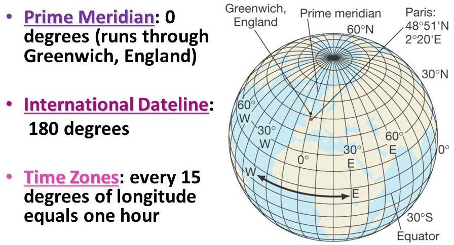
14 LOCATION Absolute location Absolute location - the precise spot where something is according to some system Most widely used: latitude and longitude Latitude: distance north or south of the equator (0 lat) Longitude: distance east or west of the prime meridian (0 long) Prime meridian passes through Greenwich, England International Date Line (180 long)

15 LOCATION
16 LOCATION Relative location Relative location - where something is in relation to other things Example: Salt Lake City, Utah is located just south of the Great Salt Lake and just west of the Rocky Mountains Often described in terms of connectivity (how well two locations are tied together by roads or other links) and accessibility (how quickly and easily people in one location can interact with people in another location)
17 LOCATION Relative location Can change over time and as accessibility changes Example: ghost towns (abandoned settlements) of the western United States once had relative locations near water sources (which dried up), along trade routes (which changed), or near mines (which closed). Their relative locations lost the advantages (resources or trade) but their absolute locations remain the same.
18 PLACE Place Place refers to the specific human and physical characteristics of a location. A group of places in the same area that share a characteristic form a region. Two ways to refer to place: site and situation Site: characteristics at the immediate location (soil type, climate) Situation: location relative to surroundings
19 PLACE Place Sense of place humans tend to perceive the characteristics of places in different ways based on their personal beliefs. Example: the characteristics of Rome, Italy, might be described differently by a local resident than by an outsider or by a Catholic than by a Hindu. If a place inspires no strong emotional ties in people, it has placelessness.
20 PLACE Place Toponyms place names Some provide insights into the physical geography, the history, or the culture of the location Example: coast of Florida (beach names), Salt Lake City, Los Angeles Some can be confusing (Iceland and Greenland) while some are deceiving (Lake City, Iowa not on a lake and Mount Prospect, Illinois is only 665 ft above sea level)
21 DISTANCE Distance is the measurement of how far or how near things are to one another Proximity indicates the degree of nearness Meters, miles, kilometers, etc. Straight line distance (as the crow flies) or travel distance Example: Milwaukee to Kalamazoo is 130 miles by air but 250 miles by car
22 DISTANCE Distance and Time Time-space compression is the shrinking time distance between locations because of improved methods of transportation and communication Example: New York and London are separated by an ocean, but the development of air travel greatly reduced travel time between them and now feel much closer today than in the 19 th century Result: global forces are influencing culture everywhere and reducing local diversity more than ever before
23 DISTANCE Distance and Connection Spatial interaction refers to the contact, movement, and flow of things between locations physical (through roads) or information (through radio or Internet) The increasing connection between places is reflected in the growth of spatial interaction The friction of distance indicates that when things are farther apart, they tend to be less well connected This inverse relationship is called distance-decay
24 DISTANCE Example: the weakening of a radio signal as it travels across space away from a radio tower friction of distance causes the decay, or weakening, of the signal. Improvements in transportation, communication, and infrastructure have reduced the friction as they have increased the spatial interaction.

25 DENSITY AND DISTRIBUTION Density Density is the number of something in a specifically defined area Population density is the number of people per square mile count the people and divide by the area Psychological density in a full elevator, one person may think it feels fine while one person feels uncomfortable
26 DENSITY AND DISTRIBUTION Distribution Distribution is the way a phenomenon is spread out over an area Clustered or sparse For example, two city blocks with the same density (amount of people) might have very different distributions evenly spread out vs. high-rise apartment and empty park Geographers look for patterns in distribution: linear (towns along a railroad line), circular (homes of people who shop at a store), geometric (squares formed by roads), or random (pet owners)
27 DENSITY AND DISTRIBUTION Distribution Matching patterns of distribution is called spatial association and indicates that two (or more) phenomena may be related, or associated with one another Example: the distribution of malaria matches the distribution of the mosquito that carries it (be careful correlation does not mean causation) Example: distribution of bike shops in a large city might be similar to the distribution of athletic wear stores. One does not cause the other but may reflect the distribution of active people

28 HUMAN-ENVIRONMENTAL INTERACTION The relationship between humans and the natural world are at the heart of human geography The connection and exchange between them is called humanenvironmental interaction specifically sustainability, pollution, and environmental issues
29 HUMAN-ENVIRONMENTAL INTERACTION Cultural ecology: the study of how humans adapt to the environment The belief that landforms and climate are the most powerful forces shaping human behavior and societal development is called environmental determinism In the 19 th and early 20 th centuries, some people used this concept to argue that people in some climates were superior to those of other climates
30 HUMAN-ENVIRONMENTAL INTERACTION In reaction came the view known as possibilism a view that acknowledges limits on the effects of the natural environment and focuses more on the role that human culture plays Different cultures may respond to the same environment in different ways, depending on their beliefs, goals, and available technologies
31 LEARNING OBJECTIVE (1.B.2) By the end of this section, you will be able to use landscape analysis to examine the human organization of space. Landscape analysis (e.g., field observations, photographic interpretations) provides a context for understanding the location of people, places, regions, and events; human environment relationships; and interconnections between and among places and regions
32 LANDSCAPE ANALYSIS Landscape analysis is the task of defining and describing land Observation and Interpretation The first part of landscape analysis is field observation Take notes, sketch maps, count, measure, and interview Before technology, this was the only way to gather data about a place


33 LANDSCAPE ANALYSIS Built environment refers to the physical artifacts that humans have created and that form part of the landscape Examples: buildings, roads, signs, and fences The built environment varies from place to place (think China vs. Germany) Anything built by humans is part of the cultural landscape.
34 FOUR-LEVEL ANALYSIS One systematic way to study geographic phenomena is to use Four-Level Analysis. Level Description Key Questions 1. Comprehension Establish the basic information clearly What? Where? When? Scale? 2. Identification Identify and describe patterns in phenomena Are phenomena connected? 3. Explanation Explain how individual phenomena might form a pattern 4. Prediction Explain why a pattern is important, and predict what it might lead to Why is something where it is? How did it get there? So what? What if? What are the effects?
35 ESSENTIAL QUESTIONS Write these down in your notes 1. What tools and techniques do geographers use to analyze the world? 2. Why do we use different scales on different maps?
36 ENDURING UNDERSTANDING (1.C) By the end of this section, you will understand that geographical skills provide a foundation for analyzing world patterns and processes.
37 LEARNING OBJECTIVE (1.C.1) By the end of this slide, you will be able to use spatial thinking to analyze the human organization of space. People apply spatial concepts to interpret and understand population and migration; cultural patterns and processes; political organization of space; agriculture, food production, and rural land use; industrialization and economic development; and cities and urban land use.


38 LEARNING OBJECTIVE (1.C.2) By the end of this section, you will be able to use and interpret maps. Maps are used to represent and identify spatial patterns and processes at different scales Types of maps include reference maps and thematic maps All map projections inevitably distort spatial relationships

39 PART II: PATTERNS AND PROCESSES Geographers emphasize spatial patterns, general arrangements of things being studied, and the processes, the repeated sequences of events, that create them.
40 MAPS Scale Maps are a reduction of the actual land it represents Scale is the ratio between the size of things in the real world and the size of those same things on the map Three types: cartographic, geographic, and scale of data
41 MAPS - SCALE Scale Maps are a reduction of the actual land it represents Scale is the ratio between the size of things in the real world and the size of those same things on the map Three types: cartographic, geographic, and scale of data
42 MAPS - SCALE Cartographic Scale Refers to the way the map communicates the ratio of its size to the size of what it represents: Words one inch equals ten miles (2.5 inches would equal 25 miles on the surface of the earth Ratio 1/200,000 or 1:200,000 (1 unit on the map equals 200,000 units on the ground) Line length of the line indicates distance on the map
43 MAPS - SCALE Geographic Scale Sometimes called relative scale, refers to the amount of territory that the map represents Global scale means a map of the entire planet Local scale means a map of a city school attendance boundaries A rise in unemployment might be explained differently depending on the scale

44 MAPS - SCALE Scale of the Data The scale of the maps might be the same but the scale of the data may be different
45 MAPS REFERENCE AND THEMATIC Reference Maps Political human-created boundaries (states, cities, etc.) Physical natural features (mountains, rivers, deserts) Road highways, streets, and alleys Plat property lines and land ownership Locator used in books and advertisements to support ad
46 MAPS REFERENCE AND THEMATIC Thematic Maps Show spatial aspects of information or of a phenomenon Four common types Choropleth Dot distribution Graduated symbol Isoline

47 MAPS THEMATIC: CHOROPLETH Choropleth Uses various colors, shades of one color, or patterns to show the location and distribution of spatial data

48 MAPS THEMATIC: DOT DISTRIBUTION Dot Distribution Used to show the specific location and distribution of something across the territory of the map Each dot represents a specified quantity

49 MAPS THEMATIC: GRADUATED SYMBOL Graduated Symbol Uses symbols of different sizes to indicate different amounts of something The map key determines the exact amount

50 MAPS THEMATIC: ISOLINE Isoline Uses lines that connect points of equal value to depict variations in the data across space Where lines are close together, change is rapid Most common type: topographic map

51 MAPS THEMATIC: ISOLINE Topographic Popular among hikers Points of equal elevation are connected creating contours that depict surface features
52 MAPS CARTOGRAMS Cartograms Sizes of countries are shown according to some specific statistic Useful because they allow data to be compared, like a graph, and distance and distribution are also visible, like on a traditional map.
53 MAPS CARTOGRAMS
54 MAPS CARTOGRAMS
55 ESSENTIAL QUESTIONS Write these down in your notes 1. Why are map projections distorted? 2. What are the three types of regions? 3. What are the geospatial technologies?
56 PROJECTIONS We know that the earth is round and maps are flat Therefore, all maps distort some aspect of reality (SADD shape, area, distance, or direction) The process of showing a curved surface on a flat surface is done using a map projection There are 5 projections you need to know

57 PROJECTIONS - MERCATOR Purpose navigation Strengths directions are accurate; lines of latitude and longitude meet at right angles Distortion distance between lines of longitude appear consistent; land masses near the poles appear large.

58 PROJECTIONS - PETERS Purpose spatial distributions related to area Strengths sizes of land masses are accurate Distortion shapes are inaccurate, especially near the poles

59 PROJECTIONS PETERS OVER MERCATOR

60 PROJECTIONS - CONIC Purpose general use in midlatitude countries Strengths lines of longitude converge; lines of latitude are curved; size and shape are close to reality Distortion directions are not constant; longitude lines converge at one pole

61 PROJECTIONS GOODE-HOMOLOSINE Purpose spatial distribution Strengths area and shape are preserved Distortion interrupts the oceans
62 ENDURING UNDERSTANDING (1.C) Remember, by the end of this section, you will understand that geographical skills provide a foundation for analyzing world patterns and processes.
63 LEARNING OBJECTIVE (1.C.3) By the end of this section, you will be able to use and interpret geographic models Geographers use models as generalizations to think systematically about topics such as land use (e.g., von Thünen model, Latin American city model), industrial location (e.g., Weber model), and the distribution of settlements (e.g., Christaller s central place theory)
64 MODELS IN GEOGRAPHY Geographic models are representations of reality or theories about reality to help them see general spatial patterns, focus on the influence of specific factors, and understand variations from place to place. Models help explain, describe, and sometimes even predict spatial activity and phenomena. Two basic types: spatial and non-spatial
65 MODELS IN GEOGRAPHY - SPATIAL Spatial models illustrate theories about spatial distributions Example: agricultural land use Von Thünen model Example: industrial location least cost theory Example: distribution of cities central place theory
66 MODELS IN GEOGRAPHY NON-SPATIAL Non-spatial models illustrate theories and concepts using words, graphs, or tables. They often depict changes over time rather than across space. Example: demographic transition model (DTM) Example: Rostow s modernization model Example: Wallerstein s world-systems theory combines both spatial and non-spatial
67 FORMULAS AND GRAPHS Formulas help geographers understand how the world works and function much like models Mathematical calculations used to produce statistics Determine CBR and CDR Doubling times for population Population densities Theoretical formulas produce results that are more theoretical Rank-size rule Graphs illustrate population structures (pyramids), geographic concepts (distance-decay), and even models (DTM)
68 USE OF MODELS Von Thünen Model Generalization based on what people did, he developed a general model about agricultural land use Simplification focused on two variables (transportation and distance) Theoretical could be applied around the world but would never exactly match reality Models are never really right or wrong but are useful in understanding the world
 Remember, by the end of this section, you will understand that geographical skills")
69 ENDURING UNDERSTANDING (1.C) Remember, by the end of this section, you will understand that geographical skills provide a foundation for analyzing world patterns and processes.
70 LEARNING OBJECTIVE (1.C.4) By the end of this section, you will be able to define region as a concept, identify world regions, and understand regionalization processes. Definition of region Types of regions World regions By the end of this section, you will be able to explain and evaluate the regionalization process. Regional thinking and regionalism
71 REGIONALIZATION AND REGIONS Regionalization is the process geographers use to divide and categorize space into smaller areal units the same way a writer divides a book into chapters and then names (classifies) them. Three types of regions Formal Functional Vernacular
72 TYPES OF REGIONS: FORMAL Formal regions, sometimes called uniform regions or homogenous regions, are united by one or more traits Physical the Sahara, a vast desert in North Africa Cultural southwestern Nigeria, an area where most people speak Yoruba Economic Gold Coast of Africa (Ghana), which exports gold
73 TYPES OF REGIONS: FUNCTIONAL Functional regions, or nodal regions, are organized around a focal point and are defined by an activity that occurs across the region Often united by communication or transportation that are centered around a node Region: pizza delivery area; Node: pizza shop Region: a country; Node: capital city (political node)
74 TYPES OF REGIONS: PERCEPTUAL Perceptual regions, or vernacular regions, are defined by the informal sense of place that people ascribe to them and vary widely The American South The Middle East Upstate New York The exact boundaries depend upon the person who is defining them

75 WORLD REGIONS LARGE REGIONS Geographers divide the world into regions and subregions
76 WORLD REGIONS SUBREGIONS Subregions are large regions divided into smaller sections They share some characteristics with the rest of the larger region but is distinctive in some ways Example: Latin America covers parts of North and South America, from Mexico to Chile. As in most Latin American countries, most people in Brazil are Roman Catholics. However, most Brazilians speak Portuguese. Because of its language, Brazil is a distinct subregion.

77 WORLD REGIONS SUBREGIONS
78 WORLD REGIONS SMALLER REGIONS Subregions can be divided into smaller regions and can be based on elements of physical geography, such as climate and landform, or human geography, such as culture, politics, or economics Any one place is part of many regions or subregions Example: Florida is part of a climate region base on its warm weather, a cultural region known as the South, and an economic region known as the Sun Belt.
 By the end of this section, you will understand that geospatial technologies increase the capability for")
79 ENDURING UNDERSTANDING (1.D) By the end of this section, you will understand that geospatial technologies increase the capability for gathering and analyzing geographic information with applications to everyday life.
80 LEARNING OBJECTIVE (1.D.1) By the end of this section, you will be able to use and interpret geospatial data Geospatial technologies include GIS, GPS, remote sensing, and online mapping and visualization Geospatial data is used at all scales for personal (navigation), business (marketing), and governmental (environmental planning) purposes
81 GEOSPATIAL DATA Geospatial data includes all information that can be tied to a specific place Locations, human activities, and traits Examples: Where do speakers of Chinese live? How common is poverty in each U.S. county? Where is the dividing line in a city between students who attend one high school and those who attend another?


82 GEOSPATIAL DATA OBTAINING DATA Much of the data is obtained through fieldwork observing and recording information on location Census of the population, interviews, informal observations
 or points (fire")
83 GEOSPATIAL DATA TECHNOLOGIES Global Positioning System (GPS) Description: GPS receivers on Earth s surface use the locations of multiple satellites to determine and record a receiver s exact location Uses: precisely locating border; navigating ships, aircraft, and cars; mapping lines (trails) or points (fire hydrants)

84 GEOSPATIAL DATA TECHNOLOGIES Remote Sensing Description: the use of cameras or other sensors mounted on aircraft or satellites to collect digital images of the earth s surface Uses: determining land cover and use; monitoring environmental changes; assessing spread of spatial phenomena; weather

85 GEOSPATIAL DATA TECHNOLOGIES Geographic Information Systems (GIS) Description: computer system that can store, analyze, and display information from multiple digital maps or geospatial data sets Uses: analysis of crime data; effects of pollution; transportation/travel time analysis; urban planning
86 THE SUBWAY MAP One of the most useful, yet inaccurate, maps Shows the value of the concept of relative location Passengers did not need to know the twists and turns of the track or the actual distance between stops

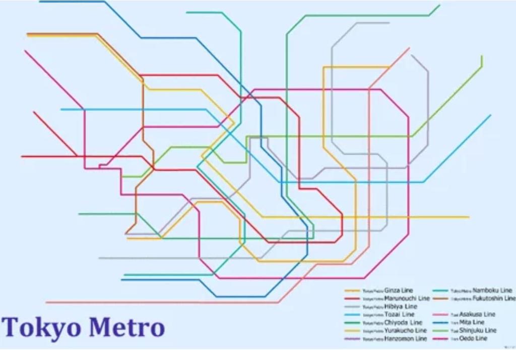
87 THE TOKYO SUBWAY MAP
Unit 1 Part 2. Concepts Underlying The Geographic Perspective
 Unit 1 Part 2 Concepts Underlying The Geographic Perspective Unit Expectations 1.B Enduring Understanding: Students will be able to.. Know that Geography offers asset of concepts, skills, and tools that
Unit 1 All. Study online at quizlet.com/_3l51hr
 Unit 1 All Study online at quizlet.com/_3l51hr 1. geography: 4. 7 APHG Units+: The study of the distribution and interaction of physical and human features on the earth 2. physical geography: 1. Geography:
AP Human Geography Chapter 1: Thinking Geographically Key Issue 1: How do Geographers describe where things are?
 AP Human Geography Chapter 1: Thinking Geographically Key Issue 1: How do Geographers describe where things are? Studying Human Geography Physical Geography Physical geography deals with Earth s natural
Chapter 1: Basic Concepts
 Chapter 1: Basic Concepts The Cultural Landscape: An Introduction to Human Geography Defining Geography Word coined by Eratosthenes Geo = Earth Graphia = writing Geography thus means earth writing Contemporary
Unit 1 The Basics of Geography. Chapter 1 The Five Themes of Geography Page 5
 Unit 1 The Basics of Geography Chapter 1 The Five Themes of Geography Page 5 Geography comes from the Greek word geographia, which means to describe the earth. Geography is the study of the distribution
Pool Canvas. Add. Creation Settings. Chapter 1--Objectives and Tools of World Regional Geography. Description Instructions.
 1 of 6 TEST BANK > CONTROL PANEL > POOL MANAGER > POOL CANVAS Pool Canvas Add, modify, and remove questions. Select a question type from the Add Question drop-down list and click Go to add questions. Use
Unit I Terms. 1.1 Terms
 Unit I Terms 1.1 Terms Space Def: area Sig: space, or spatial analysis, is at the heart of geography (like time is to historians) Projection Def: The system used to transfer locations from earth s surface
THE FIVE THEMES OF GEOGRAPHY U N I T O N E
 THE FIVE THEMES OF GEOGRAPHY U N I T O N E FIVE THEMES OF GEOGRAPHY 1. Location 2. Place 3. Human-Environment Interaction 4. Movement 5. Region LOCATION LOCATION The position that something occupies Earth
Introduction to Geography
 Introduction to Geography What is geography? Geography comes from the Greek word Geographia. Geo means earth and graphia means to describe or chart. Geographers study the earth in relation to space and
Geography involves the study of places: their locations, their characteristics, and how humans use and move around them.
 Physical Geography Looking at the Earth Geography involves the study of places: their locations, their characteristics, and how humans use and move around them. NEXT Physical Geography Looking at the Earth
Chapter 2: Studying Geography, Economics, and Citizenship
 Chapter 2: Studying Geography, Economics, and Citizenship Lesson 2.1 Studying Geography I. Displaying the Earth s Surface A. A globe of the Earth best shows the sizes of continents and the shapes of landmasses
Key Issue #1 - Why is Geography a Science?
 AP Human Geography - 1 Rubenstein s The Cultural Landscape Chapter 1: Thinking Geographically Introduction to Note Packets Reading the textbook and taking notes while reading are NECESSARY steps in processing
Name: Date: Period: #: Chapter 1: Outline Notes What Does a Historian Do?
 Name: Date: Period: #: Chapter 1: Outline Notes What Does a Historian Do? Lesson 1.1 What is History? I. Why Study History? A. History is the study of the of the past. History considers both the way things
Chapter 1: Basic Concepts
 Chapter 1: Basic Concepts The Cultural Landscape: An Introduction to Human Geography Defining Geography Word coined by Eratosthenes Geo = Earth Graphia = writing Geography thus means earth writing Contemporary
Different types of maps and how to read them.
 Different types of maps and how to read them. A map is a picture or representation of the Earth's surface, showing how things are related to each other by distance, direction, and size. Maps have been
PLEASE DO NOT WRITE ON THIS EXAM BOOKLET!
 Unit 1 Exam Version A PLEASE DO NOT WRITE ON THIS EXAM BOOKLET! 1) The importance of the spatial approach that geographers use in their studies is that it shows A) the arrangement and organization of things
MR. GOFF S WORLD HISTORY UNIT ONE: GEOGRAPHY 5 THEMES OF GEOGRAPHY
 MR. GOFF S WORLD HISTORY UNIT ONE: GEOGRAPHY 5 THEMES OF GEOGRAPHY BYOD BRING YOUR OWN DEVICE IN SMALL GROUPS (3-4), USE YOUR ELECTRONIC DEVICE(S) AND DEFINE THE FOLLOWING VOCAB. WORDS 1. GEOGRAPHY 2.
MULTIPLE CHOICE. Choose the one alternative that best completes the statement or answers the question.
 Practice Chapter 1 Exam Name MULTIPLE CHOICE. Choose the one alternative that best completes the statement or answers the question. 1) The historic diffusion of HIV/AIDS in the United States is an example
Texas Geography. Understanding the physical and human characteristics of our state
 Texas Geography Understanding the physical and human characteristics of our state To understand Texas you must first learn about its Geography. Geography- The study of the world, its people, and the interaction
Unit 1 Chapter 1. Thinking Geographically * Basics of Geography
 Global Cultures Unit 1 Chapter 1 Thinking Geographically * Basics of Geography 1.1 Geography in Greek means writing about the Earth study the Earth Geography Geographer asks: WHERE things are found on
About places and/or important events Landmarks Maps How the land is, hills or flat or mountain range Connected to maps World Different countries
 What do you think you know about geography? About places and/or important events Landmarks Maps How the land is, hills or flat or mountain range Connected to maps World Different countries What do you
Warmup. geography compass rose culture longitude
 Warmup geography compass rose culture longitude ecosystem latitude 1. study of the special physical and human characteristics of a place or region 2. learned system of shared beliefs, traits, and values
Wayne E. Sirmon GEO 301 World Regional Geography
 Wayne E. Sirmon GEO 301 Geography 301 Geography 301 MAP: A graphic representation of a portion of the earth s surface dawn to scale, as seen from above. Types of Maps Climate maps give general information
Geography Test Unit 1 Study Guide. democracy profit citizenship Bill of Rights consumers federal government political process values
 Geography Test Unit 1 Study Guide Skills Identify Longitude and Latitude Identify Continents of the World Identify Time Zones Equator Prime Meridian Hemispheres Map Requirements Oceans Compare US/Mexico/Canada
Geography Long Term Plan 2018
 Geography Long Term Plan 2018 Geography Co-ordinator: Megan Frost A high-quality geography education should inspire in pupils a curiosity and fascination about the world and its people that will remain
Chapter 02 Maps. Multiple Choice Questions
 Chapter 02 Maps Multiple Choice Questions 1. Every projection has some degree of distortion because A. a curved surface cannot be represented on a flat surface without distortion. B. parallels and meridians
AP Human Geography. Basic Concepts
 AP Human Geography Basic Concepts An in-depth Social Science Many people have misconceptions about geography and think of the discipline as simply an exercise in memorizing place names. Where we find Geography?
STUDY GUIDE. Exploring Geography. Chapter 1, Section 1. Terms to Know DRAWING FROM EXPERIENCE ORGANIZING YOUR THOUGHTS
 For use with textbook pages 19 22. Exploring Geography Terms to Know location A specific place on the earth (page 20) absolute location The exact spot at which a place is found on the globe (page 20) hemisphere
Range of Opportunities
 Geograhy Curriculum Cropwell Bishop Primary School Range of Opportunities Year 1 Year 2 Year 3 Year 4 Year 5 Year 6 All Key Stage 1 Key Stage 2 Investigate the countries and capitals of the United Kingdom.
What Is a Globe? Hemispheres. Main Idea Globes and maps provide different ways of showing features of the earth. Terms to Know
 r Main Idea Globes and maps provide different ways of showing features of the earth. Terms to Know hemisphere latitude longitude scale bar scale relief elevation contour line What Is a Globe? A globe is
Understanding Projections
 GEOGRAPHY SKILLS 1 Understanding Projections The earth is a sphere and is best shown as a globe. For books and posters, though, the earth has to be represented as a flat object. To do this, mapmakers create
Geography Can Be Cool. Seriously
 Geography Can Be Cool Seriously Why does geography matter? Geography: the study of looking at every aspect of the Earth s systems, such as human economies, societies, cultures, plants, animals, & climate.
Unit 1 Geography and Perspectives
 Unit 1 Geography and Perspectives History of Geography Began thousands of years ago with Eratosthenes and Ptolemy as mapmaking Eratosthenes calculated the circumference of the earth, only off by 175 km!
Chapter 2 - Lessons 1 & 2 Studying Geography, Economics
 Chapter 2 - Lessons 1 & 2 Studying Geography, Economics How does geography influence the way people live? Why do people trade? Why do people form governments? Lesson 1 - How Does Geography Influence the
How Geographers View the World: Human Geography. ESSENTIAL QUESTION: How does geography influence the way people live?
 How Geographers View the World: Human Geography ESSENTIAL QUESTION: How does geography influence the way people live? Geographers Think Spatially Gefffffdgfhfjgjp Guiding Question: What does it mean to
ADVANCED PLACEMENT HUMAN GEOGRAPHY
 ADVANCED PLACEMENT HUMAN GEOGRAPHY Unit One Geography: Its Nature and Perspectives Session 3 INTERPRETATION OF PLACES AND PATTERNS PLACE: THE GEOGRAPHIC TERM Place is deceptively complex. Place describes
CHAPTER 1: EXPLORING GEOGRAPHY
 CHAPTER 1: EXPLORING GEOGRAPHY Please Do Now: In your PDN section of your binder answer the following with one or two sentences: What is Geography? What is Geography? The study of where people, places,
Chapter 1 Learning Guide Thinking Geographically
 Chapter 1 Learning Guide Thinking Geographically Key Issue 1 How Do Geographers Address Where Things Are? Pgs. 2 13 1. Define map: 2. Define cartography: Maps 3. Give an example of early mapmaking and
name and locate the world s seven continents and five oceans
 Subject: Geography Activities National Curriculum Objectives One Progression of Skills Name the 7 continents and 5 oceans 3D Jigsaw task to locate continents and seas name and locate the world s seven
Geographical knowledge and understanding scope and sequence: Foundation to Year 10
 Geographical knowledge and understanding scope and sequence: Foundation to Year 10 Foundation Year 1 Year 2 Year 3 Year 4 Year 5 Year 6 Year level focus People live in places Places have distinctive features
What is Geography? Lecture 1 The Earth As A Rotating Planet. What is Geography? What is geography? Subfields of Geography?
 Lecture 1 The Earth As A Rotating Planet Geog210 Physical Geography What is Geography? Much more than place names and locations The study of spatial variation How and why things differ from place to place
6. Provide an example of developments in geography for each of the following:
 Thinking Geographically: Key Issue 1 How Do Geographers Describe Where Things Are? Rubenstein, p. 5-13 1. Define map: 2. Define cartography: MAPS 3. Give two examples of developments in early mapmaking.
The Five Themes of Geography
 The Five Themes of Geography The Five Themes of Geography Main Idea: Geographers use the Five Themes of Geography to help them study the Earth. The Five Themes of Geography Geography and You: Suppose a
Why Geography Matters
 Why Geography Matters Vocabulary words geography relative location absolute location physical feature human feature region modify adapt cause effect geography: The study of the Earth s physical and human
2. What does the map scale tell the map reader? a ratio between the actual distance on the ground and the length given to that distance on a map
 AP Human Geography - Damon Name Unit 1 - Intro to Human Geography Hour Map and Globe Skills Review Note: All links in this packet are found on our Wikispace under Map and Globe Skills Review First, read
Warm up: (8 min) Use the Map, On the Prom (Color) Paper (Blk/White) and answer the questions on your paper
 Use the Map, On the Prom (Color) Paper (Blk/White) and answer the questions on your paper") Warm up: (8 min) Use the Map, On the Prom (Color) Paper (Blk/White) and answer the questions on your paper TX History: Mapping and Geography of Texas: We will discuss some slides and write notes on others
Warm up: (8 min) Use the Map, On the Prom (Color) Paper (Blk/White) and answer the questions on your paper TX History: Mapping and Geography of Texas: We will discuss some slides and write notes on others
Map Skills Test. 1. What do we call a person who makes maps? a. mapographer b. cartographer c. geologist d. archaeologist
 Map Skills Test 1. What do we call a person who makes maps? a. mapographer b. cartographer c. geologist d. archaeologist 2. What is the name of the 0 latitude line? a. Equator b. Arctic Circle c. First
Geography. Programmes of study for Key Stages 1-3
 Geography Programmes of study for Key Stages 1-3 February 2013 Contents Purpose of study 3 Aims 3 Attainment targets 3 Subject content 4 Key Stage 1 4 Key Stage 2 5 Key Stage 3 6 2 Purpose of study A high-quality
UNIT 1 THE BASICS OF GEOGRAPHY
 UNIT 1 THE BASICS OF GEOGRAPHY CHAPTER 1 LOOKING AT THE EARTH 1 Section 1.1: The 5 Themes of Geography.Geography comes from a Greek word meaning writing about or describing the earth. Geography is: Geographers
5 Themes of Geography Review Video Notes What is Geography?
 Name PG # 5 Themes of Geography Review Video Notes What is Geography? The study of, their, and their Main Idea or Topic Continents Notes about Main Idea or Topic There are 7 Continents or in the world:
Advanced Placement Human Geography
 Advanced Placement Human Geography Introduction to AP Human Geography The Advanced Placement course in Human Geography is designed to introduce students to the systematic study of the processes that have
Geography Progression
 Geography Progression This document aims to track expectations for History within George Grenville Academy. What the National Curriculum says: KS1: Locational Knowledge: Name and locate the world s 7 continents
AP HUG REVIEW WELCOME TO 2 ND SEMESTER! Annette Parkhurst, M.Ed. January, 2015
 AP HUG REVIEW WELCOME TO 2 ND SEMESTER! Annette Parkhurst, M.Ed. January, 2015 Movement Globalization Latitude & Elevation Levels of Economic Activities CONNECTIONS Human Geography Human is the geography
LEARNING OUTCOMES SST (G1-G12)
") LEARNING OUTCOMES SST (G1-G12) Grade 1 Learning Outcomes Students will be expected to: - demonstrate an understanding of the importance of interactions between people - demonstrate an understanding of
LEARNING OUTCOMES SST (G1-G12) Grade 1 Learning Outcomes Students will be expected to: - demonstrate an understanding of the importance of interactions between people - demonstrate an understanding of
Nursery. Reception. Year 1
 Nursery Geography Overview Autumn Spring Summer Notices detailed features of objects in their environment. Comments and asks questions about aspects of their familiar world such as the place where they
Test Bank Introduction to Geography People, Places & Environment 6th Edition Carl H. Dahlman, William H. Renwick
 Test Bank Introduction to Geography People, Places & Environment 6th Edition Carl H. Dahlman, William H. Renwick Instant download and all chapters TESK BANK Introduction to Geography People, Places & Environment
GRADE 6 GEOGRAPHY TERM 1 LATITUDE AND LONGITUDE (degrees)
") 1 GRADE 6 GEOGRAPHY TERM 1 LATITUDE AND LONGITUDE (degrees) Contents Lines of Latitude... 2 Lines of Longitude... 3 The hemispheres of The Earth... 4 Finding countries and cities on a map using latitude
1 GRADE 6 GEOGRAPHY TERM 1 LATITUDE AND LONGITUDE (degrees) Contents Lines of Latitude... 2 Lines of Longitude... 3 The hemispheres of The Earth... 4 Finding countries and cities on a map using latitude
Name three countries in Europe.
 Name three countries in Europe. I will be able to identify the 5 themes of geography for Europe and locate the countries and capitals of Europe and the major physical features. People: Past: Through the
Year 34 B2 Geography - Continents and Oceans 2018 Key Skills to be covered: Taken from Level 3 Taken from Level 4
 Key Skills to be covered: Taken from Level 3 Taken from Level 4 Geographical Enquiry: I ask, Which PHYSICAL features does this place have? I ask, Which HUMAN features does this place have? I give reasons
INDIANA ACADEMIC STANDARDS FOR SOCIAL STUDIES, WORLD GEOGRAPHY. PAGE(S) WHERE TAUGHT (If submission is not a book, cite appropriate location(s))
 WHERE TAUGHT (If submission is not a book, cite appropriate location(s))") Prentice Hall: The Cultural Landscape, An Introduction to Human Geography 2002 Indiana Academic Standards for Social Studies, World Geography (Grades 9-12) STANDARD 1: THE WORLD IN SPATIAL TERMS Students
Prentice Hall: The Cultural Landscape, An Introduction to Human Geography 2002 Indiana Academic Standards for Social Studies, World Geography (Grades 9-12) STANDARD 1: THE WORLD IN SPATIAL TERMS Students
Unit 1, Lesson 2. What is geographic inquiry?
 What is geographic inquiry? Unit 1, Lesson 2 Understanding the way in which social scientists investigate problems will help you conduct your own investigations about problems or issues facing your community
0 questions at random and keep in order
 Page 1 of 5 This chapter has 36 questions. Scroll down to see and select individual questions or narrow the list using the checkboxes below. 0 questions at random and keep in order s - (20) - (11) / Questions
World Geography Fall 2013 Semester Review Project
 Reporting Category RC 1: History, Government and Citizenship Standard WG.1 History. The student understands how geography and processes of spatial exchange (diffusion) influenced events in the past and
Course Introduction II
 CULTURE GEOG 247 Cultural Geography Course Introduction II Prof. Anthony Grande Hunter College-CUNY AFG 2015 Culture is the essence of human geography because it influences all aspects of life on earth.
Chapter One. Thinking Geographically
 Chapter One Thinking Geographically Where are you? Tell me where you are. How do you know? Important Terms Map two dimensional or flat scale model of the Earth. Place A specific Point on the Earth s surface.
Chapter 1: This is Geography. Unit 1
 Chapter 1: This is Geography Unit 1 Why Is Geography a Science? Defining geography: Word coined by Eratosthenes Geo = Earth Graphia = writing Geography thus means earth writing Why Is Geography a Science?
APHuG Vocabulary: Chapter 1 Basic Concepts
 APHuG Vocabulary: Chapter 1 Basic Concepts Directions: In the spaces provided, write a definition in your own words and identify a real-world (or reasonable potential real) example for each term. Attach
INTRODUCTION TO HUMAN GEOGRAPHY. Chapter 1
 INTRODUCTION TO HUMAN GEOGRAPHY Chapter 1 What Is Human Geography? The study of How people make places How we organize space and society How we interact with each other in places and across space How we
SS 11: Human Geography
 SS 11: Human Geography INTRODUCTION TO HUMAN GEOGRAPHY & POPULATION Introduction to Human Geography Geography is the systematic study of the spatial patterns of all phenomena on or near the earth s surface.
Tuition, Medical and Behaviour Support Service
 Tuition, Medical and Behaviour Support Service Curriculum Policy - Primary Geography Reviewed: October 2018 Next Review: October 2019 Responsibility: Andrea Snow AIMS AND PRINCIPLES The national curriculum
Advanced Placement Human Geography
 Advanced Placement Human Geography I. Overview of the Course The purpose of the Advanced Placement (AP) Human Geography course is to introduce students to the systematic study of patterns and processes
A.P. Human Geography
 A.P. Human Geography 2012-2013 Instructor: Chris Vitt Brief Description of Course AP Human Geography is designed to provide students with a learning experience equivalent to that obtained in most college
1. Origins of Geography
 II. ORIGINS AND BRANCHES OF GEOGRAPHY My Notes A. Origins of Geography Unit One 6 Before carefully examining the tools of the geographer, it would be useful to examine the origins and roots of this ancient
Geography Mile Post 1
 Mile Post 1 Use world maps, atlases and globes to identify the UK and its countries, as well as the countries, continents and oceans studied at this key stage Key Skills IPC learning Goals 1.11 Be able
Map Skills and Geographic Tools
 Name: Period: Map Skills and Geographic Tools TEKS: 8.9C interpret topographic maps and satellite views to identify land and erosional features and predict how these features may be reshaped by weathering
World Geography. WG.1.1 Explain Earth s grid system and be able to locate places using degrees of latitude and longitude.
 Standard 1: The World in Spatial Terms Students will use maps, globes, atlases, and grid-referenced technologies, such as remote sensing, Geographic Information Systems (GIS), and Global Positioning Systems
Minnesota K-12 Academic Standards in Social Studies. Grade 4: Geography of North America
 Minnesota K-12 Academic s in Social Studies Grade 4: Geography of North America 4 Describe how people take 1. Democratic government action to influence a depends on informed and decision on a specific
Introduction to Geography
 Introduction to Geography ropic of Cancer 3½ N Arctic Circle 90 N Prime Meridian 0 Arctic Ocean Mississippi R. Appalachian Mts. Europe Rocky Mountains N. America Atlantic Gulf of Ocean Mexico Caribbean
1. Write down the term 2. Write down the book definition 3. Put the definition in your own words 4. Draw an image and/or put a Real Life Example
 Unit 1 Vocabulary 1. Write down the term 2. Write down the book definition 3. Put the definition in your own words 4. Draw an image and/or put a Real Life Example Absolute Location Where Is It EXACTLY?
Amarillo ISD Social Studies Curriculum
 Amarillo Independent School District follows the Texas Essential Knowledge and Skills (TEKS). All of AISD curriculum and documents and resources are aligned to the TEKS. The State of Texas State Board
MR. JOHNSON S. Geography OHIO COUNTY MIDDLE SCHOOL
 MR. JOHNSON S Geography OHIO COUNTY MIDDLE SCHOOL CHAPTER 1 Geography The science of geography is likely the oldest of all sciences. Geography is the answer to the question that the earliest humans asked,
Word Cards. 2 map. 1 geographic representation. a description or portrayal of the Earth or parts of the Earth. a visual representation of an area
 Name: Date: Hour: Word Cards 1 geographic representation a description or portrayal of the Earth or parts of the Earth Example: A map is a representation of an actual location or place. 2 map a visual
Number in your response section 1-5. Write the letter to the matching Theme of Geography. (Do not use your notes)
") Matching/Review Number in your response section 1-5. Write the letter to the matching Theme of Geography. (Do not use your notes) 1. Location a. The ability of people, goods, and ideas to spread from one
Matching/Review Number in your response section 1-5. Write the letter to the matching Theme of Geography. (Do not use your notes) 1. Location a. The ability of people, goods, and ideas to spread from one
Unit 1 Test - Version A
 Unit 1 Test - Version A 1. Approximately, how many degrees of longitude equal one time zone change? a. 5 b. 10 c. 15 d. 20 e. 25 2. The city of Lewisville has a population of 1,000 people living in 100
ST AMBROSE CATHOLIC PRIMARY SCHOOL Geography Policy
 ST AMBROSE CATHOLIC PRIMARY SCHOOL Geography Policy 2017-2018 Our school policy is developed in accordance with the National Curriculum for Geography and Foundation Stage Curriculum for Understanding of
MEADOWS PRIMARY SCHOOL and NURSERY GEOGRAPHY POLICY
 MEADOWS PRIMARY SCHOOL and NURSERY GEOGRAPHY POLICY Purpose of study The teaching of Geography at Meadows is done by following the 2014 National Curriculum. The planning and teaching of the subject aims
Unit 1, Lesson 3 What Tools and Technologies Do Geographers Use?
 Unit 1, Lesson 3 What Tools and Technologies Do Geographers Use? Geographers use a variety of tools and technologies in investigating geographic questions. Maps and globes both represent the earth, but
Geography Route Planner
 Geography Route Planner Introduction to Route Planners Route Planners outline the Key Stages 1-3 curriculum to be taught within each campus of the Bury St Edmunds Trust. Each Route Planner has been designed
Chapter 1: The World of Geography
 Chapter 1: The World of Geography Chapter 1: What is Geography? *It is the study of our earth; our home. OR *Anything that can be mapped! *Geography mixes up the physical and human aspects of our world
Borchert s Epochs of American Urbanization
 Borchert s Epochs of American Urbanization Geographers define cities as intersecting points of communication and transportation. Cities serve multiple social, political, economic and cultural purposes.
Unit 1: Introduction: Thinking Geographically, Basic Concepts
 Unit 1: Introduction: Thinking Geographically, Basic Concepts 38:180 Human Geography What does it mean to think like a geographer? Memorizing places? Countries, capital cities, rivers, etc School Geography
Complete Geography Overview: Year 1 to Year 6
 Option 1 Complete Geography Overview: Year 1 to Year 6 Autumn Term Spring Term Summer Term Year 1 Where do I live? Around the World The Four Seasons Year 2 At the Farm Let s go on Safari My World and Me
Geography Policy 2014
 Geography Policy 2014 DEFINITION Geography education should inspire in pupils a curiosity and fascination about the world and its people that will remain with them for the rest of their lives. Teaching
Curriculum Unit. Instructional Unit #1
 Curriculum Unit Name of Course: AP Human Geography Grade Level(s): 9-12 Brief Description (Course Catalog): The purpose of the AP Human Geography course is to introduce students to the systematic study
GEOGRAPHY POLICY STATEMENT. The study of geography helps our pupils to make sense of the world around them.
 GEOGRAPHY POLICY STATEMENT We believe that the study of geography is concerned with people, place, space and the environment and explores the relationships between the earth and its peoples. The study
locate the world s countries, using maps to focus on Europe (including the location of
 Year 3 and 4 Geography study- Autumn 2 2017 National curriculum: Locational knowledge locate the world s countries, using maps to focus on Europe (including the location of Russia) and North and South
Physical Geography of the United States and Canada Chapter 5 A Land of Contrasts
 Physical Geography of the United States and Canada Chapter 5 A Land of Contrasts Land Area Together the U.S. and Canada cover more than 7 million square miles. In total area, Canada ranks 2 nd and the
Houghton Mifflin Harcourt People We Know Minnesota Academic Standards in Social Studies, Grade 2
 Houghton Mifflin Harcourt People We Know 2012 correlated to the Minnesota Academic in Social Studies, Grade 2 Grade 2 2.1 Citizenship and Government 2.1.1 Civic Skills 2.1.1.1 Democratic government depends
World Geography TEKS 2nd Nine Weeks. Unit of Study Regional Studies; U.S. and Canada Regional Studies; Latin America; and Europe
 World Geography TEKS 2nd Nine Weeks Unit of Study Regional Studies; U.S. and Canada Regional Studies; Latin America; and Europe 1) History. The student understands how geography and processes of spatial
St Joseph s R.C. Primary School. Policy for Geography
 St Joseph s R.C. Primary School Policy for Geography 2016-2017 This policy is written with consideration to our school commitment to the Rights of the Child and our achievement of becoming a Rights Respecting