Geographic Information for Sustainable Development Global Trends and Perspectives
|
|
|
- Louisa Dawson
- 5 years ago
- Views:
Transcription
1 FIG President O. Univ. Prof. Dr.-Ing. Holger Magel Chair of Joint Board of Geoinformation Societies (JBGIS) Director of TUM Institute of Geodesy, GIS and Land Management on Geographic Information for Sustainable Development Global Trends and Perspectives at Map Asia 2006, 30 August in Bangkok, Thailand
2 Disposition 1. Our endangered and rapidly developing world needs sustainable development 2. Sustainable Development is not achievable without Good Governance and comprehensive Land Management 3. It s all about Geographic Information global trends and perspectives from the view of FIG


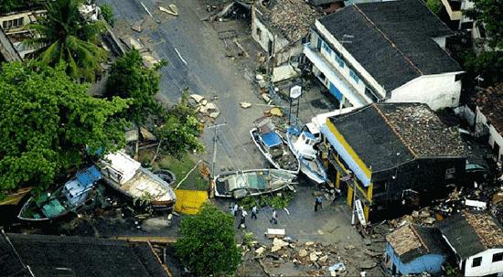
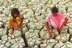
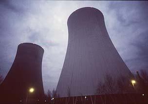
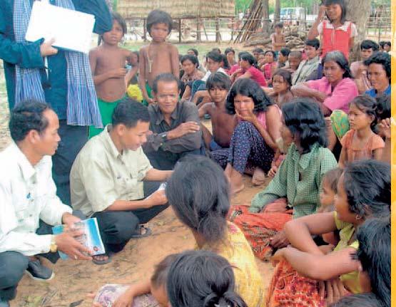
3 Our endangered and rapidly developing world


4


5


6


7


8


9

10
11 Villagers Threatened in Forced Land Expropriation April 24, 2006 Human Rights in China (HRIC) has received reports that officials have colluded with developers in Jinjiang City, Fujian Province to forcibly repossess prime farm land and a gravesite for the construction of a power station. Sources in China told HRIC that the controversy began this past February, when local officials in Jinjiang s Longhu Township began issuing eviction notices to villagers without providing for any public meeting or consultation. The notices stated that villagers would receive 25,000 yuan per mu of land for 30 mu to be repossessed for construction of a new power station. The villagers, who believed that more than 30 mu would ultimately be repossessed, objected to prime farmland being used for this purpose. For that reason, almost none of the affected villagers agreed to sell off their rights to the land. Local officials then approached the villagers again with promises of higher compensation, but the villagers firmly refused to negotiate. Sources say that at this time, township officials deployed construction officials to forcibly take possession of the land under threat of bodily harm to the villagers. Sources told HRIC that on March 22, one of the villagers telephoned two brothers surnamed Shi, who years ago had immigrated to the Philippines and Hong Kong, and told them that their grandmother s gravesite, for which they had paid 4,000 yuan in the 1990s, was being reclaimed for the power station for a compensation of 200 yuan. The brothers immediately contacted the Chinese Embassy in the Philippines to request that embassy officials investigate the matter, and to ask the Chinese government to protect the property rights of its overseas citizens. However, the brothers received no reply from the embassy, and on March 29 they learned that developers had already cut down several trees that were considered an important element in the feng shui of their grandmother s grave. HRIC is concerned that villagers of Longhu Township are at risk of losing their economic livelihoods without access to any viable remedy. HRIC is also concerned that this expropriation threatens the desecration of a grave. Incidents of forced land expropriation by local officials, made possible only under duress or threats or violence and without adequate compensation to villagers directly impacted, are on the rise across China. HRIC calls for land rights protections of rural citizens to be strengthened and implemented under Chinese law, including aligning compensation standards to the fair market value of land and securing procedural protections for farmers. Source:
12 Disposition 1. Our endangered and rapidly developing world needs sustainable development 2. Sustainable Development is not achievable without Good Governance and comprehensive Land Management 3. It s all about Geographic Information global trends and perspectives from the view of FIG
13 UN Millennium Development Plan Goals Eradicate extreme poverty and hunger Achieve universal primary education Promote gender equality and empower women Reduce child mortality Improve maternal health Combat HIV/AIDS, malaria and other diseases Ensure environmental sustainability Develop a global partnership for development Source: UN Web Services Section, Department of Public Information, United Nations (2006)
14 It is very dangerous or even contra-productive if the engagement of the global community is limited to naive optimism and a pure belief in dollars. This can be called an utopian nightmare. Poverty can be fought successfully only by a long-term therapy. Besides of more money, all states both in the north and in the south should move from the summits into the low lands of reality and practice` Arne Perres in Süddeutsche Zeitung
15 UN Development Programme's (UNDP's) CHARACTERISTICS of GOOD GOVERNANCE 1. Participation 2. Rule of Law 3. Transparency 4. Responsiveness 5. Consensus Orientation 6. Equity 7. Effectiveness and Efficiency 8. Accountability 9. Strategic Vision 10. Subsidiarity 11. Security Source:
16 Sustainable Local Authority in Partnership with the Inhabitants Public Authorities, Institutions Local Government Officials Planners, Experts Local Government Councils Citizens and their NGO s Commercial Undertakings Univ.-Prof. Dr.-Ing. Holger Magel, 2005 Lehrstuhl für Bodenordnung und Landentwicklung
17 Sustainable development,mdg and Good Governance are not attainable without sound Land Administration (LAS) Good Land Information Better Land Policy Better Land Administration and Management Better Land Use The Bathurst Declaration on Land Administration for Sustainable Development. FIG Publication No 21, 1999
18 A Land Management Vision Facilitating Facilitating Sustainable Development Economic, Economic, Social, Social, Environmental, Environmental, Governance Governance Enhancing Enhancing Quality Quality of of Life Life Land Land Policy Policy Framework Spatially Enabled Land Administration and Management Land Tenure, Land Value, Land Use, Land Development, Land Arrangement Services to to Business & Citizens Country Context Institutional Arrangements Capacity Capacity Building Building Education Education & Research Research adopted from Expert Group Meeting 9 11 November 2005 at the University of Melbourne by Prof. Magel
19 The Nairobi Statement on Spatial Information for Sustainable Development 2 nd 5 th October 2001 Nairobi, Kenya INTERNATIONAL FEDERATION OF SURVEYORS FIG in co-operation with THE UNITED NATIONS
20 Modern LAS in developed economies should facilitate sustainable development through public participation and informed and accountable government decision-making in relation to the built and natural environments. The interface between the LA infrastructure, the professions and the public will increasingly be serviced by information communication technologies designed to implement e-government and e-citizenship.. L. Ting: Principles for an Integrated Land Administration to Support Sustainable Development. 2002
21 Developing countries face the challenge of pro-poor land management and administration and are aiming for as prompt as possible enhancement of authority services. These countries face the issue of how to organise land information in support of their governance. Source: Christiaan Lemmen: ICT and Land Administration. GIM International. July 2006.
22 E-citizenship is the mobilisation of society to engage in planning, use and allocation of resources, using technology to facilitate participatory democracy. E-government involves putting government information and processes on-line, and using digital systems to assist public access. E-governance is e-democracy helping to govern society through the use of the Web. Prof. Stig Enemark, FIG Vice-president: The Emerging Land Management Paradigm a major challenge for the global surveying community. In: Geomatics World. July/August 2006.
23 Disposition 1. Our endangered and rapidly developing world needs sustainable development 2. Sustainable Development is not achievable without Good Governance and comprehensive Land Management 3. It s all about Geographic Information global trends and perspectives from the view of FIG
24 The most important change is that geospatial information is becoming more widely used and appreciated by professionals and the public. This is at least partly because technology is providing the means to collect data, extract information and distribute it to a very wide range of users; but is also because people see a need for geospatial information. The general public sees this through the media, which reports on wars and disasters with the help of satellite data, and through the use of in-car navigation systems. Prof. Ian Dowman, ISPRS President: Promoting Capacity Building. In: GIM International. July 2006.
25 Professionals and government see it through the response to disasters on the ground and through such possibilities as road charging. There is therefore strong pressure on the geospatial industry to produce the information which is required and the tools to use it effectively. There is a clear trend towards making use of all available data and integrating it to generate the required information. Prof. Ian Dowman, ISPRS President: Promoting Capacity Building. In: GIM International. July 2006.
26 Some say that GIS is not actually going mainstream because the marketing focus is too orientated towards specialist groups. What would you say to these sceptics?... Nevertheless, enterprise solutions and IT strategies that include GIS are growing rapidly. We see it in our business growth and the interest being shown by a whole new community of users. GIS is increasingly being implemented as enterprise information systems. This goes far beyond simply spatially enabling business tables in a DBMS. Interview with Jack Dangermond, President and Founder, ESRI. GIM International. August 2006
27 A Changing Role for GIS Utilities, telecommunications, transportation and civil government are traditional GIS markets in the sense that they are long-term users of GIS. But lots of things are changing: 1. Need to share and access geospatial information at an enterprise level (not only as department tool) 2. Issue around data is no longer acquisition or format but fitness for purpose (e.g. accurate data!) 3. The trend of information sharing continues, so web enablement of applications and changing their architecture to thinner clients will remain 4. Changes in legislation: EU and national legislation is becoming a big drive for IT incl. GIS J. Renard. Infotech Enterprises Ltd. In: GEOInformatics. July/August 2006
28 New Markets of GIS 1. Greater use of GIS in segments like insurance and risk underwriting 2. Online and ASP mapping markets are linked to traditional GIS markets 3. GIS usage in the personal navigation market J. Renard. Infotech Enterprises Ltd. In: GEOInformatics. July/August 2006
29 Future Role/Function of GIS The issue is less about GIS as a series of standalone applications, but more about how geospatial data, information and functionality, which typically resides within a GIS, can be used and leveraged across an organisation. J. Renard. Infotech Enterprises Ltd. In: GEOInformatics. July/August 2006
30 The integration of spatial information, including temporal aspects, will increasingly be embedded in processes leading to optimised decision making and transparency. Communication, cooperation and networking form the basis for knowledge sharing processes, and will create a shifting mindset that is more efficient and dynamic, enabling geo-data to be used effectively in the development of a modern society. G. Muggenhuber, R. Mahoney: Changing Minds in an Evolving Society. FIG Article of the Month. July 2006
31 The real challenge is to understand people s approach to the utilisation of technologies and services and to make decisions at the policy level But who should understand? G. Muggenhuber, R. Mahoney: Changing Minds in an Evolving Society. FIG Article of the Month. July 2006
32 ...it is the LEADERS!!!!!!! Many leaders of land-administration organisations are kept away from strategic issues and are too busy with the daily problems they experience in service delivery. However, leadership is necessary to develop the future in accordance with clearly set government requirements. Source: Christiaan Lemmen: ICT and Land Administration. GIM International. July 2006.


33 The Strategic Alignment model of Venkatraman, Henderson and Oldach, 1993 is a framework to Alignment Business (strategic and operational) and IT Strategy (see also Henderson et alii, 1992)
34 (They describe) Four Dominant Alignment Perspectives towards the analytic alignment of Business and IT: 1. Strategy Execution: this perspective views the business strategy as the driver of both organization design choices and the logic of IS infrastructure (the classic, hierarchical view of strategic management). Top Management is strategy formulator, IS Management is strategy implementer. [Arrow 1] 2. Technology Potential: this perspective also views the business strategy as the driver, however involves the articulation of an IT strategy to support the chosen business strategy and the corresponding specification of the required IS infrastructure and processes. The top management should provide the technology vision to articulate the logic and choices pertaining to IT strategy that would best support the chosen business strategy, while the role of the IS manager should be that of the technology architect - who efficiently and effectively designs and implements the required IS infrastructure that is consistent with the external component of IT strategy (scope, competences and governance). [Arrow 2] Source: The Strategic Alignment model of Venkatraman, Henderson and Oldach, 1993
35 3. Competitive Potential: this alignment perspective is concerned with the exploitation of emerging IT capabilities to impact new products and services (i.e., business scope), influence the key attributes of strategy (distinctive competences), as well as develop new forms of relationships (i.e. business governance). Unlike the two previous perspectives that considered business strategy as given (or a constraint for organizational transformation), this perspective allows the modification of business strategy via emerging IT capabilities. The specific role of the top management to make this perspective succeed is that of the business visionary, who articulates how the emerging IT competences and functionality as well as changing governance patterns in the IT marketplace would impact the business strategy. The role of the IS manager, in contrast, is one of the catalyst, who identifies and interprets the trends in the IT environment to assist the business managers to understand the potential opportunities and threats from an IT perspective. [Arrow 3] Source: The Strategic Alignment model of Venkatraman, Henderson and Oldach, 1993
36 4. Service Level: This alignment perspective focuses on how to build world class IT/IS organization within an organization. In this perspective, the role of business strategy is indirect. This perspective is often viewed as necessary (but not sufficient) to ensure the effective use of IT resources and be responsive to the growing and fast-changing demands of the end-user population. The specific role of the top management to make this perspective succeed is that of the prioritizer, who articulates how best to allocate the scarce resources both within the organization as well as in the IT marketplace (in terms of joint ventures, licensing, minority equity investments, etc.). The role of the IS manager, in contrast, is one of business leadership, with the specific tasks of making the internai business succeed within the operating guidelines from the top management. [Arrow 4] Source: The Strategic Alignment model of Venkatraman, Henderson and Oldach, 1993
37 Venkatraman et alii argue: The difficulty to realize value from IT investments is 1. due to the lack of alignment between the business and IT strategy of the organizations that are making investments, and 2. due to the lack of a dynamic administrative process to ensure continuous alignment between the business and IT domains. Source: The Strategic Alignment model of Venkatraman, Henderson and Oldach, 1993
38 GLOBAL GEO(geographic)INFORMATION-TRENDS and PERSPECTIVES from the view of FIG In the field of spatial or geo(graphic) information management the changes that are occurring can best be observed by considering four interrelated areas: 1. Geo-Tools (GIS-Technology) 2. Geo-Data (Spatial Data) 3. Geo-Processes/Geo-Business 4. Geo-Cooperation Human Interactions Compiled by G.Muggenhuber,R.Mahoney,R.Mansberger,FIG A.Donaubauer and S.Mayer,TUMGIS
39 Global GI Trends and Perspectives 1. Geo-Tools Improved Systems (everybody can use positioning service like GPS, combined with mobile phones, PDAs and mobile GIS systems: - increased interoperability - increased performance - increased functionality - decreased size (handhelds) - decreased prize compiled by Muggenhuber, G.,Mansberger, R et alii.
40 Global GI Trends and Perspectives 1. Geo-Tools New Developments: - Web-Mapping/Web services/web-gis - e-commerce/e-government - Location-Based Services/mobile GIS Solutions - High Resolution Satellite images and digital photogrammetric sensors - Low cost navigation systems (e.g. car-navigation) - HR Airborne Laser Scanning - Improvements in GNSS compiled by Muggenhuber, G., Mansberger, R.
41 1. Geo-Tools Global GI Trends and Perspectives Improved Network-Services - Improved rate of internet penetration in the world - New web access tools (AJAX, XML) - Modern image tiling techniques for Web-based 3D visualization. - Online Access to also cost-free spatial viewers (Google Earth and Microsoft Virtual Earth) for a broad mass as drivers for spatial data infrastructure services - Future research activities to improve web searching (semantic web, topic maps) compiled by Muggenhuber, G., Mansberger, R.
42 Global GI Trends and Perspectives 1. Geo-Tools International Standards - Interoperability standards are required to allow the merging of different/heterogeneous data sets and to combine geo-data services (e.g. formats, exchange and inter-operability; gateways and protocols; communication equipment, software) - Open Geospatial Consortium (OGC) and the official standardisation organisations (ISO, CEN) address the Interoperability issue. compiled by Muggenhuber, G., Mansberger, R.
43 Global GI Trends and Perspectives 2. Geo-Data Background - Data are going public (e-government, e-citizen) - data are referring to rather different reference frames a challenge for experts Extension of database-contents: - natural resources - economic and development oriented data compiled by Muggenhuber, G., Mansberger, R.
44 2. Geo-Data Global GI Trends and Perspectives Ensuring the Integrity and Validity of Databases (make available accurate, detailed and reliable geo-information) Need of Query Shells as a front-end decision support tool for GIS databases to fulfil the various needs of decisions making. Filtering data streams to extract meaningful information is needed for environmental monitoring, security, infrastructure operations and transportation applications. compiled by Muggenhuber, G., Mansberger, R.
45 Global GI Trends and Perspectives 2. Geo-Data Metadata - Metadata describe the data model, the thematic content, quality, geometric accuracy, spatial reference system, quality and administration - Development of Metadata standards as part of a National Spatial Information Infrastructure (NSII) - Open access to users for metadata (e.g. INSPIRE) - The research on Metadata Management of Resource and Environment Spatial Database Metadata is of high priority compiled by Muggenhuber, G., Mansberger, R.
46 Global GI Trends and Perspectives 3. Geo-Processes / Geo Businesses: Background: - National Mapping Agencies were the main producers for GI/Geo-data and public bodies were the main customers - Now Geo-information/Geo-data is often produced and maintained by companies who want to make a profit - Sensors are penetrating our world widely with new possibilities of applications (monitoring and controlling) compiled by Muggenhuber, G., Mansberger, R.
47 Global GI Trends and Perspectives 3. Geo-Processes / Geo Businesses / E-Government: Integration of GIS in mainstream IT: GIS is now accepted as a mainstream technology within government GIS became a key tool for Sustainable Development (environmental and natural resource management agencies) GIS is not any longer an end in itself compiled by Muggenhuber, G., Mansberger, R.
48 Global GI Trends and Perspectives 3. Geo-Processes / Geo Businesses: GI as fundamental for security issue (risk management, emergency management) GI as a market product: - Development of an electronic market place on GI products (e-market, e-commerce) - Pricing is critical issue in the delivery process of geo-data compiled by Muggenhuber, G., Mansberger, R.
49 Global GI Trends and Perspectives 3. Geo-Processes / Geo Businesses: Paradigm Shift: Geospatial industry is moving from a technology-driven niche to a customer-orientated service. Solutions on demand instead of Data in the stock GIS as business tool: GI is not just a technology it is increasingly part of the way in which commerce, government and academia operate. Approximately 80 % of administrative and economic decisions are based on spatial information. compiled by Muggenhuber, G., Mansberger, R.
50 Global GI Trends and Perspectives 3. Geo-Processes / Geo Businesses: Promoting GI: - GIS is in order to protect our homes, our friends, and our own lives and to organise remedial measures. - GIS teaches us how to respect nature and how to understand her actions. - GI distributes spatial information to hundreds of millions people almost immediately via Internet GIS/standardised Web-Services. - Promotion activities are required to raise awareness among potential users about the benefits of using geo-information products. compiled by Muggenhuber, G., Mansberger, R.
51 Global GI Trends and Perspectives 4. Geo Cooperation Human Interactions: Background: - NSDI institutional cooperation is still a weakness it requires cultural change/mental shift Cooperation to get added value: The collection of information often was done isolated by specific institutions without scrutinising the existing demand of merged data to get added value. This often led to a shortfall in the return on investment compiled by Muggenhuber, G., Mansberger, R.
52 Global GI Trends and Perspectives 4. Geo Cooperation Human Interactions: New Public Management: National Mapping Agencies (NMA) introduce(d) business models of the private sector, like project management, management by objectives, cost accounting, and quality management, to achieve a more efficient administration. The concept provides the transition of NMA from a position of power and authority to business-, and customer-orientated service institutions. compiled by Muggenhuber, G., Mansberger, R.
53 Global GI Trends and Perspectives 4. Geo Cooperation Human Interactions: Competition: Public Authorities are now in competition with other geo-data providers, like the organisations, which produce high resolution satellite imagery or those who produce high-resolution digital elevation models, often collected with advanced data acquisition techniques, like laser altimetry and mobile GIS. PPP (Public-Private-Partnership) is required: Co-ordination is a major problem of GI: huge number of players and stakeholders, e.g. data collectors, software vendors, data brokers, citizens and end users. Even within government, multiple departments are inevitably involved, all with their own agendas set by different Ministers. compiled by Muggenhuber, G., Mansberger, R.
54 Global GI Trends and Perspectives 4. Geo Cooperation Human Interactions: Acquisition of Customer Needs: Before value-added services can be created, it is necessary that the targeted end-users have been identified, that the requirements they put on the data products and services are known, and that their experience, skills and system configurations have been recognised. Promoting GI to key leaders: Consequently, actively influencing the key and leading decision makers about the benefit from the introduction of a GI. compiled by Muggenhuber, G., Mansberger, R.
55 Global GI Trends and Perspectives 4. Geo Cooperation Human Interactions: GI as tool for citizen Empowerment: GI will be accepted as a means towards more public participation, supporting the empowerment of citizens. Citizens watch (instead of being watched!) and participate in planning and decisions affecting their lives and interests. That is an important contribution to building up a Cicil Society and local democracy! compiled by Muggenhuber, G., Mansberger, R.
56 Currently there are three innovations promoting the technical progress in the field of Geo-information: web-services, mobile GIS linked to satellite positioning systems (GPS; GLONNASS, GALILEO) and so-called Earth-Viewer like Google Earth. The opening up of the geo-information market of Google, Microsoft, Yahoo and other companies will vitalise the development and particularly modify the profitable geo-data market. I expect for this year perhaps even before the Intergeo 2006 the first contracts will be entered between land surveying offices and Google or Microsoft about the use of geo-data Prof. Schilcher, TUM Chair of the Round Table GIS e.v. Greetings on Geobasis-information strategies, implementation, trends Stuttgart, July 2006
57 Global Trend: Spatial Information and GI technology become mass media Number of GIS users in the 1980s GIS developers knowledgeable GIS users GIS non-experts Number of GIS users in the 1990s Number of GIS users in Reasons: - technical advancements: - web technology / interoperability - data aquisition techniques: high resolution remote sensing sensors, high resolution airborne laser scanning - SDI initiatives (not really yet) - investment in data and technology from outside the traditional GIS segment: MICROSOFT VIRTUAL EARTH, GOOGLE EARTH...

 spatial")


58 Effects on sustainable development High resolution spatial information and related technology are available to all citizens (GIS-non-experts) spatial awareness empowerment through better information more participation oil spill in Lebanon Environmental Economic Social embankment dam in China Favela in Rio de Janeiro


 Chair: BMWA decide specific tasks work out of draft")
59 Common Development of Geo Data Infrastructure Germany GDI-DE (NSDI Federal and Länder) GDI and Geo Information Economy Example North Rhine Westphalia Länder Level GDI.NRW Public-private-partnership more than 130 members of administration, economy and science GI-Committee Representatives of administration, economy, science Chair: State Chancellery decide work out of draft resolution name an agent advice IMA GDI.NRW Chair: IM give the task of doing support authorize an agent recommend the realisation Working group of the state secretaries and German-Online in the Federation and the Länder decide concepts Governing body GDI-DE the Federation and the Länder, local associations Chair: BMI decide specific tasks develop strategic concepts Governing body IMAGI Co-operation within the federal administration Chair: BMI work out of draft decisions coordinate advice Federal Level GIW Commission associations, companies of geo information economy (GIW) Chair: BMWA decide specific tasks work out of draft decisions GDI.NRW Controlling body Office at the Administration of Cadastre GDI-DE Office GIW Office ALKIS, ATKIS, ALKIS-Chance für den GEO-Berufsstand und die Geoinformationswirtschaft , DVW Tagung am GFZ Potsdam


60 o See you at the XXIII FIG Congress with INTERGEO 2006 in Munich: The World Cup for Surveyors!
From Surveying to Geomatics and Land Management. About Future Perspectives of a Changing Discipline and Profession
 FIG President and Chair of Joint Board of Geospatial Information Societies O. Univ. Prof. Dr.-Ing. Holger Magel Director of TUM Institute of Geodesy, GIS and Land Management on From Surveying to Geomatics
Spatially Enabled Society
 International Seminar on Land Administration Trends and Issues in Asia and the Pacific Region Spatially Enabled Society Abbas Rajabifard Vice Chair PCGIAP-WG3 Vice-President (President Elect), GSDI Association
Implementing the Sustainable Development Goals: The Role of Geospatial Technology and Innovation
 Fifth High Level Forum on UN Global Geospatial Information Management Implementing the Sustainable Development Goals: The Role of Geospatial Technology and Innovation 28-30 November 2017 Sheraton Maria
Open spatial data infrastructure
 Open spatial data infrastructure a backbone for digital government Thorben Hansen Geomatikkdagene 2018 Stavanger 13.-15. mars Spatial Data Infrastructure definition the technology, policies, standards,
THE ROLE OF GEOSPATIAL AT THE WORLD BANK
 THE ROLE OF GEOSPATIAL AT THE WORLD BANK INSPIRE Conference Barcelona, Spain September 26, 2016 Kathrine Kelm Senior Land Administration Specialist Global Land and Geospatial Unit The World Bank Group
COMMISSION 3 SPATIAL INFORMATION MANAGEMENT WORK PLAN
 Appendix to item 34.3 FIG Congress in Washington, 19-26 April 2002 COMMISSION 3 SPATIAL INFORMATION MANAGEMENT WORK PLAN 2002 2006 1. Title Spatial Information Management. 2. Terms of Reference - Management
KUNMING FORUM ON UNITED NATIONS GLOBAL GEOSPATIAL INFORMATION MANAGEMENT CITIES OF THE FUTURE: SMART, RESILIENT
 KUNMING FORUM ON UNITED NATIONS GLOBAL GEOSPATIAL INFORMATION MANAGEMENT CITIES OF THE FUTURE: SMART, RESILIENT and SUSTAINABLE Yunnan Zhenzhuang Guest House, Kunming, China 10 12 May 2017 BACKGROUND CONCEPT
Briefing. H.E. Mr. Gyan Chandra Acharya
 Briefing by H.E. Mr. Gyan Chandra Acharya Under-Secretary-General and High Representative for the Least Developed Countries, Landlocked Developing Countries and Small Island Developing States Briefing
The Global Statistical Geospatial Framework and the Global Fundamental Geospatial Themes
 The Global Statistical Geospatial Framework and the Global Fundamental Geospatial Themes Sub-regional workshop on integration of administrative data, big data and geospatial information for the compilation
E-Government and SDI in Bavaria, Germany
 135 E-Government and SDI in Bavaria, Germany Wolfgang STOESSEL, Germany Key words: GDI-BY, Bavaria, Spatial Data Infrastructure SUMMARY Spatial Data Infrastructure (SDI) is an important part of the e-government
Economic and Social Council
 United Nations Economic and Social Council Distr.: General 18 July 2016 Original: English Committee of Experts on Global Geospatial Information Management Sixth session New York, 3-5 August 2016 Item 2
UN-GGIM: Strengthening Geospatial Capability
 Fifth Plenary Meeting of UN-GGIM: Europe Brussels, 6-7 June 2018 UN-GGIM: Strengthening Geospatial Capability Walking the talk to leave no one behind Greg Scott, UN-GGIM Secretariat Environmental Statistics
Roadmap to interoperability of geoinformation
 Roadmap to interoperability of geoinformation and services in Europe Paul Smits, Alessandro Annoni European Commission Joint Research Centre Institute for Environment and Sustainability paul.smits@jrc.it
The future of SDIs. Ian Masser
 The future of SDIs Ian Masser Presentation Considers two questions relating to the future development of SDIs throughout the world Where have we got to now? Where should we go from here? Identifies four
EuroSDR (European Spatial Data Research)
") EuroSDR (European Spatial Data Research) ROLLING RESEARCH PLAN 2015-2018 EuroSDR Secretariat Public Governance Institute KU Leuven Parkstraat 45 bus 3609 3000 Leuven Belgium Tel.: +32 16 32 31 80 Fax:
EuroSDR (European Spatial Data Research) ROLLING RESEARCH PLAN 2015-2018 EuroSDR Secretariat Public Governance Institute KU Leuven Parkstraat 45 bus 3609 3000 Leuven Belgium Tel.: +32 16 32 31 80 Fax:
Economic and Social Council
 United Nation E/C.20/2012/4/Add.1 Economic and Social Council Distr.: General 2 July 2012 Original: English Committee of Experts on Global Geospatial Information Management Second session New York, 13-15
GSDI Global Spatial Data Infrastructure. Convergences between Geo Spatial Communities: key decision for decision making
 GSDI Global Spatial Data Infrastructure Convergences between Geo Spatial Communities: key decision for decision making April 14 th 2010 Bas Kok GSDI Past-President Director of International Affairs, Dutch
Building a national spatial data infrastructure. Thorben Hansen, Head of Division Danish Agency for Data Supply and Efficiency
 Building a national spatial data infrastructure Thorben Hansen, Head of Division Danish Agency for Data Supply and Efficiency About Spatial Data Infrastructure Spatial data come from many sources and is
UN GGIM and National SDI Strategy
 MSDI Open Forum on 26 th January 2016 Contributing to the successful delivery of MSDI UN GGIM and National SDI Strategy Hiroshi Murakami Deputy Administrator Geospatial Information Authority of Japan Geospatial
What s the problem? A Modern Odyssey in Search of Relevance. The search for relevance. Some current drivers for new services. Some Major Applications
 A Modern Odyssey in Search of Relevance FIG Working Week, Athens, 24 May 2004 Paul Kelly ANZLIC Executive Director The search for relevance 1. New expectations for spatial services 2. Are we ready to meet
Ready for INSPIRE.... connecting worlds. European SDI Service Center
 Ready for INSPIRE Consultancy SOFTWARE T r a i n i n g Solutions... connecting worlds European SDI Service Center Increasing Added Value with INSPIRE and SDI Components INSPIRE In 2007, the European Commission
Update to the Association of Ontario Land Surveyors February 27, 2015 Deerhurst, Ontario
 1 Update to the Association of Ontario Land Surveyors February 27, 2015 Deerhurst, Ontario Peter Sullivan CLS, ALS, MBA Director General, Surveyor General Branch Earth Sciences Sector, Natural Resources
Sustainable and Harmonised Development for Smart Cities The Role of Geospatial Reference Data. Peter Creuzer
 Sustainable and Harmonised Development for Smart Cities The Role of Geospatial Reference Data Peter Creuzer 1. Introduction - Smart Cities and Geodata 2. Geodata in Germany 3. Examples 4. Data and Service
Concept Formulation of Geospatial Infrastructure. Hidenori FUJIMURA*
 Concept Formulation of Geospatial Infrastructure 1 Concept Formulation of Geospatial Infrastructure Hidenori FUJIMURA* (Published online: 28 December 2016) Abstract Technical trends in the field of surveying
Putting the U.S. Geospatial Services Industry On the Map
 Putting the U.S. Geospatial Services Industry On the Map December 2012 Definition of geospatial services and the focus of this economic study Geospatial services Geospatial services industry Allow consumers,
Disaster Management & Recovery Framework: The Surveyors Response
 Disaster Management & Recovery Framework: The Surveyors Response Greg Scott Inter-Regional Advisor Global Geospatial Information Management United Nations Statistics Division Department of Economic and
Country Report on SDI Activities in Singapore *
 UNITED NATIONS E/CONF.100/CRP.9 ECONOMIC AND SOCIAL COUNCIL Eighteenth United Nations Regional Cartographic Conference for Asia and the Pacific Bangkok, 26-29 October 2009 Item 7(a) of the provisional
Background Document: Report of the Regional Committee of United Nations Global Geospatial Information Management for Asia and the Pacific
 Background Document: Report of the Regional Committee of United Nations Global Geospatial Information Management for Asia and the Pacific 1. Summary 1. This report highlights the activities carried out
RETA 6422: Mainstreaming Environment for Poverty Reduction Category 2 Subproject
 RETA 6422: Mainstreaming Environment for Poverty Reduction Category 2 Subproject A. Basic Data 1. Subproject Title: Poverty-Environment Mapping to Support Decision Making 2. Country Director: Adrian Ruthenberg
Realizing benefits of Spatial Data Infrastructure A user s perspective from Environment Agency - Abu Dhabi
 Realizing benefits of Spatial Data Infrastructure A user s perspective from Environment Agency - Abu Dhabi Anil Kumar Director, Environment Information Management 26 April 2012 Geospatial World Forum,
XXIII CONGRESS OF ISPRS RESOLUTIONS
 XXIII CONGRESS OF ISPRS RESOLUTIONS General Resolutions Resolution 0: Thanks to the Czech Society commends: To congratulate The Czech Society, its president and the Congress Director Lena Halounová, the
Arctic Spatial Data Infrastructure Enabling Access to Arctic Location-Based Information
 Arctic Spatial Data Infrastructure Enabling Access to Arctic Location-Based Information Arctic SDI Side Event Co-Chairs: Arvo Kokkonen Arctic SDI Board Chair & Director General, National Land Survey of
Concept note. High-Level Seminar: Accelerating Sustainable Energy for All in Landlocked Developing Countries through Innovative Partnerships
 Concept note High-Level Seminar: Accelerating Sustainable Energy for All in Landlocked Developing Countries through Innovative Partnerships Date: 24 and 25 October 2016 Venue: Conference Room C3, Vienna
REGIONAL SDI DEVELOPMENT
 REGIONAL SDI DEVELOPMENT Abbas Rajabifard 1 and Ian P. Williamson 2 1 Deputy Director and Senior Research Fellow Email: abbas.r@unimelb.edu.au 2 Director, Professor of Surveying and Land Information, Email:
FIG Asia Pacific Capacity Development Network
 FIG Asia Pacific Capacity Development Network Report to the 41th General Assembly FIG Congress 2018, Istanbul - Turkey Rob Sarib Chair FIG Asia Pacific Capacity Development Network (AP CDN) Story of the
THE RESEARCH GOALS AND THE RESEARCH STRATEGY OF THE EuroSDR
 THE RESEARCH GOALS AND THE RESEARCH STRATEGY OF THE EuroSDR Martien Molenaar Vice President of EuroSDR International Institute for geo-information Science and Earth Observation (ITC) Enschede, The Netherlands
The Swedish National Geodata Strategy and the Geodata Project
 The Swedish National Geodata Strategy and the Geodata Project Ewa Rannestig, Head of NSDI Co-ordination Unit, Lantmäteriet, ewa.rannstig@lm.se Ulf Sandgren, Project Manager Geodata Project, Lantmäteriet,
Economic and Social Council
 United Nations Economic and Social Council Distr.: General 2 July 2012 E/C.20/2012/10/Add.1 Original: English Committee of Experts on Global Geospatial Information Management Second session New York, 13-15
The Integrated Ge spatial Information Framework to the strengthening of NSDI, Mongolia
 Young Geospatial Professionals Summit 21 NOV 2018 The Integrated Ge spatial Information Framework to the strengthening of NSDI, Mongolia BAYARMAA ENKHTUR Geospatial information and technology department
Economic and Social Council 2 July 2015
 ADVANCE UNEDITED VERSION UNITED NATIONS E/C.20/2015/11/Add.1 Economic and Social Council 2 July 2015 Committee of Experts on Global Geospatial Information Management Fifth session New York, 5-7 August
2018/1 The integration of statistical and geospatial information. The Regional Committee of UN-GGIM: Americas:
 The following are the conclusions and recommendations of the Regional Committee of the United Nations on Global Geospatial Information Management for the Americas, during its Fifth Session, Thursday 8
Voices from Private Sector: Insights for Future NSDI Development in Indonesia
 Voices from Private Sector: Insights for Future NSDI Development in Indonesia Ta n d a n g Yu l i a d i D w i P u t ra, Ryosuke S h i b a s a k i I n st i t u t e o f I n d u st r i a l S c i e n c e,
Innovation in Land Management: Integrated Solutions For National Cadastre Projects
 Success With GIS Innovation in Land Management: Integrated Solutions For National Cadastre Projects XXIII International FIG Congress Munich These documents are only complete, when used in connection with
Land Use in the context of sustainable, smart and inclusive growth
 Land Use in the context of sustainable, smart and inclusive growth François Salgé Ministry of sustainable development France facilitator EUROGI vice president AFIGéO board member 1 Introduction e-content+
Global Geospatial Information Management Country Report Finland. Submitted by Director General Jarmo Ratia, National Land Survey
 Global Geospatial Information Management Country Report Finland Submitted by Director General Jarmo Ratia, National Land Survey Global Geospatial Information Management Country Report Finland Background
ECONOMIC AND SOCIAL COUNCIL
 UNITED NATIONS E/CONF.102/3 ECONOMIC AND SOCIAL COUNCIL Nineteenth United Nations Regional Cartographic Conference for Asia and the Pacific Bangkok, 29 October 1 November 2012 Item 4 of the provisional
8th FIG Regional Conference November 2012 Montevideo, Uruguay
 8th FIG Regional Conference 26 29 November 2012 Montevideo, Uruguay Platinum Sponsors: Member Associations; Affiliate Members; Academic Members; Corporate Members & Correspondents 120 Countries 1 FIG Foundation
Building a National Data Repository
 Building a National Data Repository Mladen Stojic, Vice President - Geospatial 1/30/2013 2012 Intergraph Corporation 1 Information has meaning and gives power only when shared and distributed. Information,
A Modern Odyssey in Search of Relevance
 A Modern Odyssey in Search of Relevance Paul KELLY, Australia Key words: Capacity building, GIM, spatial data infrastructure. SUMMARY A modern country has a voracious appetite for spatial information.
Prof Chryssy Potsiou, FIG President
 THE VALUE OF GEOSPATIAL DATA AND ROLE OF SURVEYORS IN SUSTAINABLE DEVELOPMENT Prof Chryssy Potsiou, FIG President National Technical University of Athens School of Rural and Surveying Engineering, Greece
Presented to Sub-regional workshop on integration of administrative data, big data and geospatial information for the compilation of SDG indicators
 Presented to Sub-regional workshop on integration of administrative data, big data and geospatial information for the compilation of SDG indicators 23-25 April,2018 Addis Ababa, Ethiopia By: Deogratius
Ministry of ICT of I.R.IRAN
 The ECO 8/6 mill km 2 10 Slamic countries ~330 mill people Oil, Gas, Industries,Tourism 2 Issue transformation in last decade Problem solving needs more integrated approach More interaction &complexity
GSDI: Towards a Spatially Enabled Society
 GSDI: Towards a Spatially Enabled Society Dr. David J. Coleman, President Global Spatial Data Infrastructure Association UN Regional Cartographic Conference for the Americas, United Nations, New York,
Cooperation is the key, FIG can facilitate
 Cooperation is the key, FIG can facilitate Mikael Lilje Vice President 2017-2020 Head, Geodetic infrastructure, Swedish mapping, cadastral and land registration authority Presented at the GIS/RS Conference
Proposal for a DIRECTIVE OF THE EUROPEAN PARLIAMENT AND OF THE COUNCIL. establishing an infrastructure for spatial information in the Community
 Proposal for a DIRECTIVE OF THE EUROPEAN PARLIAMENT AND OF THE COUNCIL establishing an infrastructure for spatial information in the Community INSPIRE http://inspire.jrc.it/ Alessandro Annoni 1 EU Commission
Spatially Enabled Society Role of the Cadastre
 Spatially Enabled Society Role of the Cadastre Daniel STEUDLER, Switzerland and Abbas RAJABIFARD, Australia Key words: Spatially enabled society, Land administration, Cadastre SUMMARY The evolution from
A Broad View of Geospatial Technology & Systems
 A Broad View of Geospatial Technology & Systems Pete Large Vice President, Trimble On the shoulders of giants 1 Since their time, our ability to generate geospatial information has grown exponentially
Cartographic and Geospatial Futures
 Cartographic and Geospatial Futures 1. Web Cartography, WebGIS, & Virtual Globes--New Roles for Maps, GIS, and GIS professionals 2. Map Mashups, the Neo Neo-geography Movement, & Crowd-sourcing Geospatial
SWEDISH SDI DEVELOPMENT & IMPLEMENTATION OF INSPIRE
 SWEDISH SDI DEVELOPMENT & IMPLEMENTATION OF INSPIRE Christina Wasström, Lantmäteriet, 801 82 Gävle, Sweden, christina.wasstrom@lm.se ABSTRACT The Swedish Government and Parliament has given Lantmäteriet
INDONESIA S S UPDATE: GEOSPATIAL INFORMATION FOR SUSTAINABLE DEVELOPMENT RELATED TO INA SDI Dr. Asep Karsidi, M.Sc
 INDONESIA S S UPDATE: GEOSPATIAL INFORMATION FOR SUSTAINABLE DEVELOPMENT RELATED TO INA SDI Dr. Asep Karsidi, M.Sc GEOSPATIAL INFORMATION AGENCY 08 August, 2012 OUTLINE 1. Transformation Bakosurtanal into
Aboriginal communities strengthen governance with location-based tools in the 21st century
 Aboriginal communities strengthen governance with location-based tools in the 21st century Today, Aboriginal communities are taking advantage of the geomatics technologies that underpin popular online
INSPIRE Basics. Vlado Cetl European Commission Joint Research Centre. https://ec.europa.eu/jrc/
 INSPIRE Basics Vlado Cetl European Commission Joint Research Centre https://ec.europa.eu/jrc/ Serving society Stimulating innovation Supporting legislation Outline SDI? Why European SDI? INSPIRE Policy
CHARTING SPATIAL BUSINESS TRANSFORMATION
 CHARTING SPATIAL BUSINESS TRANSFORMATION An in-depth look at the business patterns of GIS and location intelligence adoption in the private sector EXECUTIVE SUMMARY The global use of geographic information
Ministry of Health and Long-Term Care Geographic Information System (GIS) Strategy An Overview of the Strategy Implementation Plan November 2009
 Strategy An Overview of the Strategy Implementation Plan November 2009") Ministry of Health and Long-Term Care Geographic Information System (GIS) Strategy An Overview of the Strategy Implementation Plan November 2009 John Hill, Health Analytics Branch Health System Information
Ministry of Health and Long-Term Care Geographic Information System (GIS) Strategy An Overview of the Strategy Implementation Plan November 2009 John Hill, Health Analytics Branch Health System Information
What is Spatial Planning?
 Spatial Planning in the context of the Responsible Governance of Tenure What is Spatial Planning? Text-only version This course is funded by the European Union through the EU-FAO Improved Global Governance
Country Report On Sdi Activities In Singapore ( )
") UNITED NATIONS E/CONF.102/IP.4 ECONOMIC AND SOCIAL COUNCIL Nineteenth United Nations Regional Cartographic Conference for Asia and the Pacific Bangkok, 29 October 1 November 2012 Item 6(b) of the provisional
UNITED NATIONS E/CONF.102/IP.4 ECONOMIC AND SOCIAL COUNCIL Nineteenth United Nations Regional Cartographic Conference for Asia and the Pacific Bangkok, 29 October 1 November 2012 Item 6(b) of the provisional
International Guidelines on Access to Basic Services for All
 International Guidelines on Access to Basic Services for All Presentation and initials lessons from implementation Accessibility to services in regions and cities : measures and policies, OECD 18 June
The Role of Urban Planning and Local SDI Development in a Spatially Enabled Government. Faisal Qureishi
 The Role of Urban Planning and Local SDI Development in a Spatially Enabled Government Faisal Qureishi 1 Introduction A continuous increase in world population combined with limited resources has lead
The National Spatial Strategy
 Purpose of this Consultation Paper This paper seeks the views of a wide range of bodies, interests and members of the public on the issues which the National Spatial Strategy should address. These views
GEOGRAPHIC INFORMATION SYSTEMS Session 8
 GEOGRAPHIC INFORMATION SYSTEMS Session 8 Introduction Geography underpins all activities associated with a census Census geography is essential to plan and manage fieldwork as well as to report results
GIS (GEOGRAPHICAL INFORMATION SYSTEMS) AS A FACILITATION TOOL FOR SUSTAINABLE DEVELOPMENT IN AFRICA
 AS A FACILITATION TOOL FOR SUSTAINABLE DEVELOPMENT IN AFRICA") GIS (GEOGRAPHICAL INFORMATION SYSTEMS) AS A FACILITATION TOOL FOR SUSTAINABLE DEVELOPMENT IN AFRICA a presentation by Elizabeth Hicken GDEST Conference on Geospatial Sciences for Sustainable Development
GIS (GEOGRAPHICAL INFORMATION SYSTEMS) AS A FACILITATION TOOL FOR SUSTAINABLE DEVELOPMENT IN AFRICA a presentation by Elizabeth Hicken GDEST Conference on Geospatial Sciences for Sustainable Development
ADDRESSING THE DATA AND INFORMATION NEEDS FOR GOOD GOVERNANCE, SHARING EXPERIENCES FROM COTE D IVOIRE. 20 April 2016 to 22 April 2016 ADDIS ABABA
 20 April 2016 to 22 April 2016 ADDIS ABABA ADDRESSING THE DATA AND INFORMATION NEEDS FOR GOOD GOVERNANCE, SHARING EXPERIENCES FROM COTE D IVOIRE Dr. Edouard FONH-GBEI Director General of CNTIG, General
US National Spatial Data Infrastructure A Spatial Framework for Governance and Policy Development to Enable a Location-Based Digital Ecosystem
 GeoPlatform Workshop 7 Dec 2016, Department of the Interior Washington, D.C. US National Spatial Infrastructure A Spatial Framework for Governance and Policy Development to Enable a Location-Based Digital
Declaration Population and culture
 Declaration Population and culture The ministers of the parties to the Alpine Convention regard the socio-economic and socio-cultural aspects mentioned in Article 2, Paragraph 2, Item a., as being central
About FIG s and Surveyors Contributions to building a better world
 O. Univ.-Prof. Dr.-Ing. Holger Magel President of FIG Director of TUM Institute of Geodesy, GIS and Land Management about About FIG s and Surveyors Contributions to building a better world at XIX International
The GIS Path Forward Saskatchewan s Geomatics Strategic Plan
 The GIS Path Forward Saskatchewan s Geomatics Strategic Plan John Potter, SK Ministry of Central Services Office of Geomatics Coordination Sept.17/13 Table of Contents 1. 2011-2016, Geomatics Strategic
Non-Governmental Organizations for Spatial Data Infrastructure. Environmental Democracy Case
 Non-Governmental Organizations for Spatial Data Infrastructure Environmental Democracy Case L.Jovičić, S.Vrečar, V.Cetl, K.Ristovski GSDI Small Grant Program Award 2011-2012 Non-Governmental Organisations
Status of implementation of the INSPIRE Directive 2016 Country Fiches. COUNTRY FICHE Netherlands
 Status of implementation of the INSPIRE Directive 2016 Country Fiches COUNTRY FICHE Netherlands Introduction... 1 1. State of Play... 2 1.1 Coordination... 2 1.2 Functioning and coordination of the infrastructure...
Bengt Kjellson Chair of the Executive Committee UN-GGIM: Europe. 2 nd Joint UN-GGIM: Europe ESS Meeting 11 th March 2016, Luxembourg
 Bengt Kjellson Chair of the Executive Committee UN-GGIM: Europe 2 nd Joint UN-GGIM: Europe ESS Meeting 11 th March 2016, Luxembourg A global geospatial mandate At its 47th plenary in July 2011, ECOSOC,
Plan4all (econtentplus project)
") Plan4all (econtentplus project) Karel CHARVAT 1, Tomáš MILDORF 2 1 Help service remote sensing, Ltd., Černoleská 1600, 256 01 Benešov u Prahy, Czech Republic charvat@bnhelp.cz 2 Department of Mathematics
Plan4all (econtentplus project) Karel CHARVAT 1, Tomáš MILDORF 2 1 Help service remote sensing, Ltd., Černoleská 1600, 256 01 Benešov u Prahy, Czech Republic charvat@bnhelp.cz 2 Department of Mathematics
FINDINGS OF THE ARCTIC METEOROLOGY SUMMIT
 FINDINGS OF THE ARCTIC METEOROLOGY SUMMIT 2018 WWW.FMI.FI CHAIR S SUMMARY: 1 2 3 We need to be curious to explore the known unknowns. Meteorology is an elemental part of international collaboration in
The German GDI a public-private cooperation project. Heinz BRÜGGEMANN Surveying and Mapping Agency NRW, Germany
 The German GDI a public-private cooperation project Heinz BRÜGGEMANN Surveying and Mapping Agency NRW, Germany Definition of Grimm Public tasks are all action lines..., which are handled by public actors,
GEOMATICS ENGINEERING A TRADITIONAL DISCIPLINE TRANSFORMED IN AN INFORMATION TECHNOLOGY ERA
 Contents Page Presented at AEESEAP 99 Midterm Conference Bangkok, Thailand, May 12-14, 1999 GEOMATICS ENGINEERING A TRADITIONAL DISCIPLINE TRANSFORMED IN AN INFORMATION TECHNOLOGY ERA by Ian P. Williamson
Analysis of Regional Fundamental Datasets Questionnaire
 Permanent Committee on GIS Infrastructure for Asia and the Pacific Working Group 2 Regional Fundamental Data Summary Report on Analysis of Regional Fundamental Datasets Questionnaire ABBAS RAJABIFARD and
Challenges and Potentials of Place Based Information Management in Nepal"
 Nineteenth United Nations Regional Cartographic Conference for Asia and the Pacific, Bangkok, Thailand, 29 October 1 November 2012 Challenges and Potentials of Place Based Information Management in Nepal"
Adding value to Copernicus services with member states reference data
 www.eurogeographics.org Adding value to Copernicus services with member states reference data Neil Sutherland neil.sutherland@os.uk GIS in the EU 10 November 2016 Copyright 2016 EuroGeographics 61 member
Increasing GI awareness in local authorities in Poland experiences from the INSPIRE Academy training programme
 Increasing GI awareness in local authorities in Poland experiences from the INSPIRE Academy training programme http://www.akademiainspire.pl Maria Andrzejewska, Monika Rusztecka UNEP/GRID-Warsaw Centre,
SDI-Challenges European perspective
 THE HIGH LEVEL FORUM ON GLOBAL GEOSPATIAL INFORMATION MANAGEMENT Seoul, Republic of Korea, 24-26 October 2011 Session 1: Challenges in geospatial policy formation and institutional arrangements SDI-Challenges
Government GIS and its Application for Decision Support
 Government GIS and its Application for Decision Support Zhang Qingpu (Chinese Academy of Surveying and Mapping, Email: zhangqp@casm.ac.cn) Abstract: Application of GIS in government agencies is called
Geospatial Information and Sustainable Development (Rio+20) A Belgian perspective
 A Belgian perspective") Geospatial Information and Sustainable Development (Rio+20) A Belgian perspective In the resolution adopted by the General Assembly, The future we want World leaders acknowledged the need to further mainstream
Geospatial Information and Sustainable Development (Rio+20) A Belgian perspective In the resolution adopted by the General Assembly, The future we want World leaders acknowledged the need to further mainstream
Report of the Regional Committee of UN-GGIM for Asia and the Pacific (UN-GGIM-AP)
") Report of the Regional Committee of UN-GGIM for Asia and the Pacific (UN-GGIM-AP) At the Eighth Session of UN-GGIM UN Headquarters, New York, 1 3 August 2018 About UN-GGIM-AP One of the five regional committees
Report of the Regional Committee of UN-GGIM for Asia and the Pacific (UN-GGIM-AP) At the Eighth Session of UN-GGIM UN Headquarters, New York, 1 3 August 2018 About UN-GGIM-AP One of the five regional committees
PAN AMERICAN INSTITUTE OF GEOGRAPHY AND HISTORY Specialized Organization of the OAS
 PAN AMERICAN INSTITUTE OF GEOGRAPHY AND HISTORY Specialized Organization of the OAS 10 th UNRCC Americas United Nations, New York, 20 August 2013 PAIGH, SIRGAS, PC-IDEA and GeoSUR 2013-2015 Joint Action
Challenges and Successes in Sharing Geospatial Data in Africa
 Challenges and Successes in Sharing Geospatial Data in Africa 2018 GeoNode Summit Torino, Italy March 26-28, 2018 Bernard Justus Muhwezi Manager, Geo-Information Services Uganda Bureau of Statistics, Kampala,
Compact guides GISCO. Geographic information system of the Commission
 Compact guides GISCO Geographic information system of the Commission What is GISCO? GISCO, the Geographic Information System of the COmmission, is a permanent service of Eurostat that fulfils the requirements
Basic Act on the Advancement of Utilizing Geospatial Information
 Basic Act on the Advancement of Utilizing Geospatial Information (Act No. 63 of May 30, 2007) Table of Contents Chapter I General Provisions (Articles 1 to 8) Chapter II Basic Plan for the Advancement
STATE GEOGRAPHIC INFORMATION DATABASE
 STATE GEOGRAPHIC INFORMATION DATABASE Data Information and Knowledge Management STATE GEOGRAPHIC INFORMATION DATABASE EXECUTIVE SUMMARY Utah has developed one of the most comprehensive statewide GIS resources
CHAPTER 22 GEOGRAPHIC INFORMATION SYSTEMS
 CHAPTER 22 GEOGRAPHIC INFORMATION SYSTEMS PURPOSE: This chapter establishes the administration and use of to improve the quality and accessibility of Department s spatial information and support graphical
National Spatial Data Infrastructure International workshop 9 th June, 2015 Terelj Hotel, Mongolia
 1 st session: NSDI policy, planning and the legal framework Formation of NSDI policy and legal framework in Mongolia Khurelshagai Ayurzana, Director General, Administration of Land Affairs, Geodesy and
Spatial Data Infrastructure Concepts and Components. Douglas Nebert U.S. Federal Geographic Data Committee Secretariat
 Spatial Data Infrastructure Concepts and Components Douglas Nebert U.S. Federal Geographic Data Committee Secretariat August 2009 What is a Spatial Data Infrastructure (SDI)? The SDI provides a basis for
Section 2. Indiana Geographic Information Council: Strategic Plan
 Section 2. Indiana Geographic Information Council: Strategic Plan Introduction A geographic information system (GIS) is an automated tool that allows the collection, modification, storage, analysis, and