Semantic Technologies in Prod-Trees
|
|
|
- Irma Rich
- 5 years ago
- Views:
Transcription


1 European Geosciences Union General Assembly 2014 Prod Trees Kallirroi Dogani Vienna Austria 29 April
2 Outline 2 The Prod-Trees architecture Supported ontologies Cross-ontology browser Ontology mapping EO-netCDF Reasoner
3 The Prod-Trees architecture 3

")
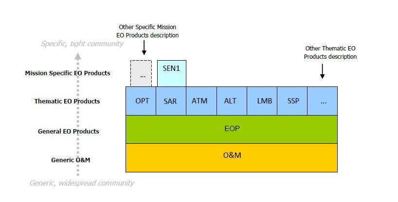
4 Supported Ontologies (1/4) 4 GEMET: GEneral Multilingual Environmental Thesaurus Ø common general language for the environment Ø 5200 terms in 33 languages Ø thematic retrieval through a set of 40 themes agreed upon with the EEA (e.g. biology, energy, water, soil)


5 Supported Ontologies (2/4) 5 NASA GCMD: Global Change Master Directory Ø a complete catalogue of NASA s earth science datasets relevant to global change o Climate change, the atmosphere, biosphere, hydrosphere and oceans, geology, human dimensions of global change etc. Ø ~ 1000 earth science terms in a subject taxonomy Ø part of NASA s Earth Observing System Data and Information System (EOSDIS)

 o agriculture, biodiversity,")

6 Supported Ontologies (3/4) 6 GEOSS: Global Earth Observation System of Systems Ø is being built by the Group on Earth Observations (GEO) Ø 9 environmental fields of interest (Societal Benefit Areas) o agriculture, biodiversity, climate, disasters, ecosystems, energy, health, water, and weather Ø aims to connect the producers of environmental data with the end users


7 Supported Ontologies (4/4) 7 GSCDA Multi-Domain Thesaurus: GMES Space Component Data Access Ø created in OTEG project of ESA Ø extended in RARE project of ESA Ø contains semantic terms related to Earth Observation products Ø Covers 4 domains o Marine Environment o Land Monitoring o Emergency Response o Atmosphere Monitoring


8 8 Cross-Ontology Browser
9 Cross-Ontology Browser (1/2) 9 ü ontologies encoded in SKOS vocabulary ü navigation within and across the ontologies hierarchical representation of ontology concepts detailed description of every concept links between different ontologies ü keyword search ü disambiguation and discovery tool ü helps users specifying terms for their search
")
10 Cross-Ontology Browser (2/2) 10

11 11 Ontology Mapping
12 Ontology Mapping (1/2) 12 ² Mapping rules that map entities of one ontology to at most one entity of another ontology. ü Automatic creation of mappings using: String-based techniques Linguistic resources (e.g. WordNet) Structure-level techniques Alignment reuse techniques ü Mappings encoded in SKOS vocabulary skos:exactmatch skos:broadmatch skos:relatedmatch skos:narrowmatch


13 Ontology Mapping (2/2) 13 Example 1: String-based Example 2: Linguistic Example 3: Structure-level storm skos:exactmatch aquatic environment skos:narrower seismic sea wave sea wave skos:narrowmatch Cyclone skos:altlabel Storm skos:relatedmatch Marine Environment skos:exactmatch Tsunami


14 14 EO-netCDF Reasoner
15 EO-netCDF Reasoner (1/4) 15 ü a SOAP-based Web Service ü translates ontology concepts into EO-netCDF vocabulary Step 1: the ontology concept is mapped to an Application Requirements Parameter (ARP) using defined RIF rules Step 2: the ARP is mapped to an EO-netCDF term using a translation table


16 EO-netCDF Reasoner (2/4) 16 RIF Rules IF Land Ice THEN (Sensor Type = Altimetric)
 17 NetCDF EO")


17 EO-netCDF Reasoner (3/4) 17 NetCDF EO Convections Translation Table <application_requirement term="sensor Type > <related_eo_netcdf_term>/eop:earth_observation_information/ eop:earth_observation_equipment/eop:sensor_information/eop:sensor_type </related_eo_netcdf_term> </application_requirement> Observation & Measurements


18 EO-netCDF Reasoner (4/4) 18 <List> <items ordered="yes"> <Const type="xsd:string">sensor Type</Const> <Const type="xsd:string">altimetric</const> </items> </List> <List> <items ordered="yes"> <Const type="xsd:string">/eop:earth_observation_information/ eop:earth_observation_equipment/eop:sensor_information/eop:sensor_type </Const> <Const type="xsd:string">altimetric</const> </items> </List>
![Mapping to OpenSearch 19 [ ]/eop:sensor_information/eop:sensor_type Equal" à "sensor" [ ]/eop:sensor_information/eop:sensor_resolution numeric-greater-than à "sensorresolutionmin" [](/docs-images/95/124645272/images/19-0.jpg "]/eop:sensor_information/eop:sensor_resolution numeric-greater-than-or-equal à \"sensorresolutionmin\" [ ]/eop:sensor_information/eop:sensor_resolution numeric-less-than\" à \"sensorresolutionmax\" [")
![]/eop:sensor_information/eop:sensor_resolution numeric-less-than-or-equal" à "sensorresolutionmax" [ ]/sar:acquisition_information/sar:polarisation_channels Equal" à "sarpolch" [](/docs-images/95/124645272/images/19-2.jpg "]/sar:acquisition_information/sar:polarisation_mode Equal\" à \"sarpolmd\" http://example.com/services/opensearchsemanticenhanced?")
19 Mapping to OpenSearch 19 [ ]/eop:sensor_information/eop:sensor_type Equal" à "sensor" [ ]/eop:sensor_information/eop:sensor_resolution numeric-greater-than à "sensorresolutionmin" [ ]/eop:sensor_information/eop:sensor_resolution numeric-greater-than-or-equal à "sensorresolutionmin" [ ]/eop:sensor_information/eop:sensor_resolution numeric-less-than" à "sensorresolutionmax" [ ]/eop:sensor_information/eop:sensor_resolution numeric-less-than-or-equal" à "sensorresolutionmax" [ ]/sar:acquisition_information/sar:polarisation_channels Equal" à "sarpolch" [ ]/sar:acquisition_information/sar:polarisation_mode Equal" à "sarpolmd" outputformat=application%2fatom%2bxml&si=1&ct=100&bbox=&rel=&ts=&te=&st= &sensor=radar&sensorresolutionmin=500&sensorresolutionmax=1200 &sarpolch=vv&sarpolmd=s
20 20 Thank you!
A multilingual/multicultural semantic-based approach to improve Data Sharing in a SDI
 A multilingual/multicultural semantic-based approach to improve Data Sharing in a SDI Monica De Martino, Riccardo Albertoni IMATI-CNR-GE Institute of Applied Mathematics and Information Technologies, Dept.Genoa,
C o p e r n i c u s a n d W I G O S
 C o p e r n i c u s a n d W I G O S Jean-Noël Thépaut & Mark Dowell 24 October 2017 GEO XIV, Washington DC, 23-28 October 2017 T h e C o p e r n i c u s P r o g r a m m e Copernicus is the European Union
The Copernicus Climate Change (C3) service: State of play
 service: State of play") Enterprise and Industry The Copernicus Climate Change (C3) service: State of play B. Pinty (a) & J-N. Thépaut (b) (a) Copernicus G.2 unit (b) ECMWF CCI October2014 Legal frame & MS consultations Publica6on
Enterprise and Industry The Copernicus Climate Change (C3) service: State of play B. Pinty (a) & J-N. Thépaut (b) (a) Copernicus G.2 unit (b) ECMWF CCI October2014 Legal frame & MS consultations Publica6on
EU collaborations with NASA LCLUC Program & Current Priorities
 & Current Priorities ioannis Manakos, Dr. Centre for Research and Technology Hellas Information Technologies Institute Visual Analytics, Virtual & Augmented Reality Laboratory European Association of Remote
Land Monitoring Core Service Implementation Group (LMCS IG) - Results and Outlook
 - Results and Outlook") Land Monitoring Core Service Implementation Group (LMCS IG) - Results and Outlook Pr. Dietmar Grünreich, President of BKG, Germany Chairman of the GMES LMCS IG Outline 1 Introduction 2 Preparatory Projects
Land Monitoring Core Service Implementation Group (LMCS IG) - Results and Outlook Pr. Dietmar Grünreich, President of BKG, Germany Chairman of the GMES LMCS IG Outline 1 Introduction 2 Preparatory Projects
Emergency Management Service (EMS) mapping
 mapping") GMES Emergency Management Service (EMS) mapping Frédéric BASTIDE GMES unit, European Commission UN-SPIDER Expert Meeting: "Crowdsource Mapping for Disaster Risk Management and Emergency Response" 3-5 December,
GMES Emergency Management Service (EMS) mapping Frédéric BASTIDE GMES unit, European Commission UN-SPIDER Expert Meeting: "Crowdsource Mapping for Disaster Risk Management and Emergency Response" 3-5 December,
The Global Fundamental Geospatial Data Themes Journey. April Clare Hadley WG Chair
 The Global Fundamental Geospatial Data Themes Journey April 2018 Clare Hadley WG Chair The Road to here Why Global? Why Geospatial? Why Fundamental? Why Themes? The route we took Where does the road go
Tomas Mildorf New technologies for the information society University of west bohemia in pilsen, Czech republic
 Tomas Mildorf New technologies for the information society University of west bohemia in pilsen, Czech republic Karel Charvat Help Service Remote Sensing, Czech republic AIP-7 GEOSS, 20 MAY 2014 By 2015,
INSPIRE General Introduction & Service Architecture
 INSPIRATION Spatial Data Infrastructure in the Western Balkans INSPIRE General Introduction & Service Architecture 1st National INSPIRATION Workshop Croatia November 21-22, 2012 A multi-countryprojectfunded
Introduction of the Asia-Oceania Global Earth Observation System of Systems (AOGEOSS) GEO Initiative(GI-22 )
 GEO Initiative(GI-22 )") Introduction of the Asia-Oceania Global Earth Observation System of Systems (AOGEOSS) GEO Initiative(GI-22 ) Prof. Xiang ZHOU Institute of Remote Sensing and Digital Earth, CAS 11 May 2017 Kunming, China
Introduction of the Asia-Oceania Global Earth Observation System of Systems (AOGEOSS) GEO Initiative(GI-22 ) Prof. Xiang ZHOU Institute of Remote Sensing and Digital Earth, CAS 11 May 2017 Kunming, China
Laying the Foundations for Global Transdisciplinary Integration of Data from the Physical Sciences and the Social Sciences
 Laying the Foundations for Global Transdisciplinary Integration of Data from the Physical Sciences and the Social Sciences Lesley Wyborn 1, Simon Cox 2, Simon Hodson 3 and Geoffrey Boulton 4 1 National
Group on Earth Observations (GEO) Cold Regions Work Plan Item WA-01-C3
 Cold Regions Work Plan Item WA-01-C3") EC Panel of Experts on Polar Observations, Research and Services Group on Earth Observations (GEO) Cold Regions Work Plan Item WA-01-C3 Barbara J. Ryan Secretariat Director Lanzhou, China 13 March 2013
EC Panel of Experts on Polar Observations, Research and Services Group on Earth Observations (GEO) Cold Regions Work Plan Item WA-01-C3 Barbara J. Ryan Secretariat Director Lanzhou, China 13 March 2013
INSPIREd solutions for Air Quality problems Alexander Kotsev
 INSPIREd solutions for Air Quality problems Alexander Kotsev www.jrc.ec.europa.eu Serving society Stimulating innovation Supporting legislation The European data puzzle The European data puzzle 24 official
Earth Observation and GEOSS in Horizon Copernicus for Raw Material Workshop 5 th September 2016
 Earth Observation and GEOSS in Horizon 2020 Copernicus for Raw Material Workshop 5 th September 2016 Gilles OLLIER Head of Sector -Earth observation Directorate Environment Unit I.4 Climate Actions and
Climate Change Service
 Service Metadata for the Data Store Dick Dee, ECMWF C3S: data + expertise + operational Open and free access to climate data (observations, reanalyses, model predictions) Tools and best scientific practices
Geological information for Europe : Towards a pan-european Geological Data Infrastructure
 Geological information for Europe : Towards a pan-european Geological Data Infrastructure Integrating geoscientific information for EU competitiveness Co-funded by the European Union European societal
Development of an International Arctic Observations Assessment Framework
 Development of an International Arctic Observations Assessment Framework Dr. Steven Lev, Dr. Jason Gallo Briefing for the Sustaining Arctic Observing Networks (SAON) April 7, 2017 International Partners
Essential Cold Region Variables to reach societal benefits
 - Where the Poles come together Essential Cold Region Variables to reach societal benefits Yubao Qiu, Massimo Menenti and ECRV Task Team (ongoing) 2018.6 @ Davos - Switzerland /GEO Cold Regions Initiative
The ESA Earth observation programmes overview and outlook
 The ESA Earth observation programmes overview and outlook Dr. Volker Liebig Director, ESA EO Programmes ILA 2008, Berlin ENVISAT mission: 6 years! Bam earthquake Tectonic uplift (Andaman) Arctic 2007 First
Moore County Schools. High School Level
 Moore County Schools High School Level EARTH AND ENVIRONMENTAL SCIENCE Science, by nature, is an inquiry-based discipline whereby students gain knowledge through observation and experimentation. Scientific
Liana Talaue McManus. Division of Marine Affairs and Policy Rosenstiel School of Marine & Atmospheric Science University of Miami
 Liana Talaue McManus Division of Marine Affairs and Policy Rosenstiel School of Marine & Atmospheric Science University of Miami Outline 1. Coasts as vulnerable & resilient social ecological systems 2.
Understanding Weather and Climate Risk. Matthew Perry Sharing an Uncertain World Conference The Geological Society, 13 July 2017
 Understanding Weather and Climate Risk Matthew Perry Sharing an Uncertain World Conference The Geological Society, 13 July 2017 What is risk in a weather and climate context? Hazard: something with the
GMES Service for Geospatial Reference Data Access (RDA) Covering Areas Outside Europe
 Covering Areas Outside Europe") INSPIRE Conference 2011 Edinburgh 27 June - 1 July GMES Service for Geospatial Reference Data Access (RDA) Covering Areas Outside Europe Andrea Ajmar, Simone Balbo, Piero Boccardo, Simone Dalmasso, Anna
INSPIRE Conference 2011 Edinburgh 27 June - 1 July GMES Service for Geospatial Reference Data Access (RDA) Covering Areas Outside Europe Andrea Ajmar, Simone Balbo, Piero Boccardo, Simone Dalmasso, Anna
A Case Study for Semantic Translation of the Water Framework Directive and a Topographic Database
 A Case Study for Semantic Translation of the Water Framework Directive and a Topographic Database Angela Schwering * + Glen Hart + + Ordnance Survey of Great Britain Southampton, U.K. * Institute for Geoinformatics,
Copernicus Overview and Emergency Management Service
 Copernicus Overview and Emergency Management Service Frédéric BASTIDE European Commission Open informal session of the United Nations Inter-Agency Meeting on Outer Space Activities 12 March 2013, Geneva
Maritime Weather Information: Automatic Reporting, A New Paradigm
 Maritime Weather Information: Automatic Reporting, A New Paradigm Joe Sienkiewicz, NOAA/NWS Ocean Prediction Center Responsibilities under SOLAS Met Services Contracting governments Observations Limited
Climate Change. Climate Change Service
 Service The C3S m ission To support European adaptation and mitigation policies by: Providing consistent and authoritative information about climate Building on existing capabilities and infrastructures
econtentplus GS Soil
 econtentplus GS Soil General aims Assessment and strategic development of INSPIRE compliant Geodata-Services for European Soil Data BPN on basis of the EU 2007/2/EC (INSPIRE) Directive for Annex III theme
Academic Vocabulary CONTENT BUILDER FOR THE PLC WORLD GEOGRAPHY
 Academic Vocabulary CONTENT BUILDER FOR THE PLC WORLD GEOGRAPHY : academic vocabulary directly taken from the standard STANDARD WG.1A analyze the effects of physical and human geographic patterns and processes
Colorado Academic Standards for High School Science Earth Systems Science
 A Correlation of Pearson 12 th Edition 2015 Colorado Academic Standards Introduction This document demonstrates the alignment between, 12 th Edition, 2015, and the, Earth Systems Science. Correlation page
Earth System Science The contribution of remote sensing. Remote Sensing (GRS-20306)
") Earth System Science The contribution of remote sensing Remote Sensing (GRS-20306) Contents Definition of Earth System Science (ESS) Examples of ESS approaches (and limitations) Climate change (temperature)
Earth System Science The contribution of remote sensing Remote Sensing (GRS-20306) Contents Definition of Earth System Science (ESS) Examples of ESS approaches (and limitations) Climate change (temperature)
ArcGIS for INSPIRE. Marten Hogeweg
 ArcGIS for INSPIRE Marten Hogeweg Please Take Our Survey on the App Download the Esri Events app and find your event Select the session you attended Scroll down to find the feedback section Complete answers
Observation (EO) & Geomatics in Canada
 & Geomatics in Canada") Innovating to Increase the Impact of Earth Observation (EO) & Geomatics in Canada Natural Resources Canada February 25, 2014 Prashant Shukle, Director General Canada Centre for Mapping and Earth Observation
Innovating to Increase the Impact of Earth Observation (EO) & Geomatics in Canada Natural Resources Canada February 25, 2014 Prashant Shukle, Director General Canada Centre for Mapping and Earth Observation
MERSEA Marine Environment and Security for the European Area
 MERSEA Marine Environment and Security for the European Area Development of a European system for operational monitoring and forecasting of the ocean physics, biogeochemistry, and ecosystems, on global
ESBN. Working Group on INSPIRE
 ESBN Working Group on INSPIRE by Marc Van Liedekerke, Endre Dobos and Paul Smits behalf of the WG members WG participants Marc Van Liedekerke Panos Panagos Borut Vrščaj Ivana Kovacikova Erik Obersteiner
Open Data meets Big Data
 Open Data meets Big Data Max Craglia, Sven Schade, Anders Friis European Commission Joint Research Centre www.jrc.ec.europa.eu Serving society Stimulating innovation Supporting legislation JRC is Technical
US National Spatial Data Infrastructure A Spatial Framework for Governance and Policy Development to Enable a Location-Based Digital Ecosystem
 GeoPlatform Workshop 7 Dec 2016, Department of the Interior Washington, D.C. US National Spatial Infrastructure A Spatial Framework for Governance and Policy Development to Enable a Location-Based Digital
Advanced Image Analysis in Disaster Response
 Advanced Image Analysis in Disaster Response Creating Geographic Knowledge Thomas Harris ITT The information contained in this document pertains to software products and services that are subject to the
Using netcdf and HDF in ArcGIS. Nawajish Noman Dan Zimble Kevin Sigwart
 Using netcdf and HDF in ArcGIS Nawajish Noman Dan Zimble Kevin Sigwart Outline NetCDF and HDF in ArcGIS Visualization and Analysis Sharing Customization using Python Demo Future Directions Scientific Data
Copernicus Today and Tomorrow GEO Week Group on Earth Observation Geneva, 16 January 2014 The Copernicus Space Infrastructure
 Copernicus Today and Tomorrow GEO Week Group on Earth Observation Geneva, 16 January 2014 The Copernicus Space Infrastructure Thomas Beer, Policy Coordinator, Copernicus Space Office, ESA-ESRIN, Frascati
Georef - Linked Data Deployment for Spatial Data; Finnish Initiative
 Georef - Linked Data Deployment for Spatial Data; Finnish Initiative Esa TIAINEN, Finland Key words: Linked Data, Semantics, Ontology, Web, RDF, Big Data SUMMARY 'Georef' is an initiative for a service
Graduate Courses Meteorology / Atmospheric Science UNC Charlotte
 Graduate Courses Meteorology / Atmospheric Science UNC Charlotte In order to inform prospective M.S. Earth Science students as to what graduate-level courses are offered across the broad disciplines of
INSPIRE - A Legal framework for environmental and land administration data in Europe
 INSPIRE - A Legal framework for environmental and land administration data in Europe Dr. Markus Seifert Bavarian Administration for Surveying and Cadastre Head of the SDI Office Bavaria Delegate of Germany
TIGGE-LAM archive development in the frame of GEOWOW. Richard Mladek (ECMWF)
") TIGGE-LAM archive development in the frame of GEOWOW Richard Mladek (ECMWF) The group on Earth Observations (GEO) initiated the Global Earth Observation System of Systems (GEOSS) GEOWOW, short for GEOSS
TIGGE-LAM archive development in the frame of GEOWOW Richard Mladek (ECMWF) The group on Earth Observations (GEO) initiated the Global Earth Observation System of Systems (GEOSS) GEOWOW, short for GEOSS
Application of Topology to Complex Object Identification. Eliseo CLEMENTINI University of L Aquila
 Application of Topology to Complex Object Identification Eliseo CLEMENTINI University of L Aquila Agenda Recognition of complex objects in ortophotos Some use cases Complex objects definition An ontology
FINDINGS OF THE ARCTIC METEOROLOGY SUMMIT
 FINDINGS OF THE ARCTIC METEOROLOGY SUMMIT 2018 WWW.FMI.FI CHAIR S SUMMARY: 1 2 3 We need to be curious to explore the known unknowns. Meteorology is an elemental part of international collaboration in
National Climatic Data Center Data Management Issues Tom Karl Director, NOAA s National Climatic Data Center
 National Climatic Data Center Data Management Issues Tom Karl Director, NOAA s National Climatic Data Center Opening Meeting NOAA Science Advisory Board s Data Archiving and Access Requirements Working
Advancing Flood Detection and Preparedness through GEOSS Water Services
 Advancing Flood Detection and Preparedness through GEOSS Water Services David K. Arctur University of Texas at Austin Open Geospatial Consortium (OGC) CAHMDA/DAFOH Joint Workshop University of Texas at
Coastal Erosion & Climate Change: PRIDE 2005 Towards an Alaska Wind/Wave Climatology
 Coastal Erosion & Climate Change: PRIDE 2005 Towards an Alaska Wind/Wave Climatology 2 nd PRIDE Workshop August 9-10, 2005 David Atkinson, Int l Arctic Research Center, Univ. Of Alaska-Fairbanks James
Unit 2: Ecology. Big Idea...
 Name: Block: Unit 2: Ecology Big Idea... The natural world is defined by organisms and life processes which conform to principles regarding conservation and transformation of matter and energy. Knowledge
ISO Plant Hardiness Zones Data Product Specification
 ISO 19131 Plant Hardiness Zones Data Product Specification Revision: A Page 1 of 12 Data specification: Plant Hardiness Zones - Table of Contents - 1. OVERVIEW...3 1.1. Informal description...3 1.2. Data
Geographic Information Infrastructure and Policy Framework for Sustainable Mountain Development in the Hindu Kush-Himalayas
 Geo SMART ASIA 2017 22-24 August, Kualalampur Geographic Information Infrastructure and Policy Framework for Sustainable Mountain Development in the Hindu Kush-Himalayas Basanta Shrestha, Director Strategic
INSPIRE Basics. Vlado Cetl European Commission Joint Research Centre. https://ec.europa.eu/jrc/
 INSPIRE Basics Vlado Cetl European Commission Joint Research Centre https://ec.europa.eu/jrc/ Serving society Stimulating innovation Supporting legislation Outline SDI? Why European SDI? INSPIRE Policy
Plenary Session 2, part 2 A European shared information system
 3 rd GMES Forum 5 6 June 2003 Athens Plenary Session 2, part 2 A European shared information system Gordon McInnes Deputy Director European Environment Agency 1 I keep six honest serving men. They taught
INSPIRE Directive. Status June 2007
 INSPIRE Directive INfrastructure for SPatial InfoRmation in Europe Status June 2007 European Commission Directorate-General Environment Research, Science and Innovation Unit Rue de la Loi, 200 1049 Brussels
Contribution to global Earth observation from satellites
 Contribution to global Earth observation from satellites - JAXA s Earth Observation strategy - April 16, 2008 Makoto Kajii Japan Aerospace Exploration Agency Earth Observation Summits and GEOSS 1 st EO
Environmental Science (Revised August 2011)
") Environmental Science (Revised August 2011) Ongoing Student Learning Expectations Strand: Nature of Science Standard 4: Students shall use mathematics, science equipment, and technology as tools to communicate
Environmental Science (Revised August 2011) Ongoing Student Learning Expectations Strand: Nature of Science Standard 4: Students shall use mathematics, science equipment, and technology as tools to communicate
Ontology Summit 2016: SI Track: SI in the GeoScience Session 1: How is SI Viewed in the GeoSciences"
 Ontology Summit 2016: SI Track: SI in the GeoScience Session 1: How is SI Viewed in the GeoSciences" February 25, 2016 Some Introductory Comments on the Track Topic Gary Berg-Cross Ontolog, RDA US Advisory
Copernicus EMS: Αξιολόγηση πολλαπλών φυσικών κινδύνων - Σχεδιασμός και Ανάκτηση
 Building Capacity for a Centre of Excellence for EO-based monitoring of Natural Disasters Copernicus EMS: Αξιολόγηση πολλαπλών φυσικών κινδύνων - Σχεδιασμός και Ανάκτηση Γιάννης Παπουτσής ΙΑΑΔΕΤ Εθνικό
Study on Data Integration and Sharing Standard and Specification System for Earth System Science
 Study on Data Integration and Sharing Standard and Specification System for Earth System Science Juanle Wang and Jiulin Sun Information Sharing Center for Earth System Science Institute of Geographic Sciences
New NASA Ocean Observations and Coastal Applications
 New NASA Ocean Observations and Coastal Applications Duane Armstrong Chief, Applied Science & Technology Project Office August 20, 2014 1 Outline NASA s new Earth Science Ocean Science Missions for 2014
A BRIEF INTRODUCTION TO COPERNICUS AND CAMS
 A BRIEF INTRODUCTION TO COPERNICUS AND CAMS Juan Garcés de Marcilla Director of Copernicus Services European Centre for Medium-Range Weather Forecasts Copernicus EU Copernicus EU Copernicus EU www.copernicus.eu
D.5.1: report on user requirements for the EuroGEOSS Drought operating capacity Revised Version
 Project start date: 01 May 2009 Acronym: EuroGEOSS Project title: EuroGEOSS, a European Theme: FP7-ENV-2008-1: Environment (including climate change) Theme title: ENV.2008.4.1.1.1: European Environment
SITMUN: Cooperating to Build Local SDIs in the Barcelona Region
 SITMUN: Cooperating to Build Local SDIs in the Barcelona Region Diputació de Barcelona Territory and Sustainability Area Territorial Information Systems Department INSPIRE CONFERENCE Barcelona, September
The Open Geospatial Consortium and EarthCube
 The Open Geospatial Consortium and EarthCube An EarthCube Technology Paper Prepared by David Maidment 1, Ben Domenico 2, Alastair Gemmell 3, Kerstin Lehnert 4, David Tarboton 5 and Ilya Zaslavsky 6 Introduction
Geoscience Australia Report on Cal/Val Activities
 Medhavy Thankappan Geoscience Australia Agency Report I Berlin May 6-8, 2015 Outline 1. Calibration / validation at Geoscience Australia Corner reflector infrastructure for SAR calibration (for information)
Using the EartH2Observe data portal to analyse drought indicators. Lesson 4: Using Python Notebook to access and process data
 Using the EartH2Observe data portal to analyse drought indicators Lesson 4: Using Python Notebook to access and process data Preface In this fourth lesson you will again work with the Water Cycle Integrator
Proposition Knowledge Graphs. Gabriel Stanovsky Omer Levy Ido Dagan Bar-Ilan University Israel
 Proposition Knowledge Graphs Gabriel Stanovsky Omer Levy Ido Dagan Bar-Ilan University Israel 1 Problem End User 2 Case Study: Curiosity (Mars Rover) Curiosity is a fully equipped lab. Curiosity is a rover.
Climate Modeling Research & Applications in Wales. John Houghton. C 3 W conference, Aberystwyth
 Climate Modeling Research & Applications in Wales John Houghton C 3 W conference, Aberystwyth 26 April 2011 Computer Modeling of the Atmosphere & Climate System has revolutionized Weather Forecasting and
the map Redrawing Donald Hobern takes a look at the challenges of managing biodiversity data [ Feature ]
![the map Redrawing Donald Hobern takes a look at the challenges of managing biodiversity data [ Feature ]](/thumbs/82/86628837.jpg "the map Redrawing Donald Hobern takes a look at the challenges of managing biodiversity data [ Feature ]") Redrawing the map Donald Hobern takes a look at the challenges of managing biodiversity data 46 Volume 12 > Number 9 > 2008 www.asiabiotech.com Cicadetta sp., Canberra, Australia, December 2007 Photograph
Redrawing the map Donald Hobern takes a look at the challenges of managing biodiversity data 46 Volume 12 > Number 9 > 2008 www.asiabiotech.com Cicadetta sp., Canberra, Australia, December 2007 Photograph
Taxonomies of Building Objects towards Topographic and Thematic Geo-Ontologies
 Taxonomies of Building Objects towards Topographic and Thematic Geo-Ontologies Melih Basaraner Division of Cartography, Department of Geomatic Engineering, Yildiz Technical University (YTU), Istanbul Turkey
Rob Thomas, Adam Leadbetter and Roy Lowry BODC
 Rob Thomas, Adam Leadbetter and Roy Lowry BODC Controlled vocabularies Reduce ambiguity inherent in normal human languages where the same concept can be given different names and ensure consistency. Takes
European Space Agency
 Guidelines - Guidelines how/when to interact during the WebEx session: - Due to the number of attendees, please keep always your webcam and microphone switched-off - You can use anytime the chat to all
Geographic Analysis of Linguistically Encoded Movement Patterns A Contextualized Perspective
 Geographic Analysis of Linguistically Encoded Movement Patterns A Contextualized Perspective Alexander Klippel 1, Alan MacEachren 1, Prasenjit Mitra 2, Ian Turton 1, Xiao Zhang 2, Anuj Jaiswal 2, Kean
WMO Space Programme: anticipated evolution and a Picture of Development of a Vision of WIGOS Space-based Component in 2040
 WMO Space Programme: anticipated evolution and a Picture of 2040 --Development of a Vision of WIGOS Space-based Component in 2040 Wenjian Zhang Director, Observing and Information Systems Department &
Atmospheric Science and GIS Interoperability issues: some Data Model and Computational Interface aspects
 UNIDATA Boulder, Sep. 2003 Atmospheric Science and GIS Interoperability issues: some Data and Computational Interface aspects Stefano Nativi University of Florence and IMAA-CNR Outline Service-Oriented
IRDAT Fvg, evolving a regional Spatial Data Infrastructure according to INSPIRE
 IRDAT Fvg, evolving a regional Spatial Data Infrastructure according to INSPIRE Tutti i diritti riservati. Proprietà INSIEL SpA. A. Benvenuti, A. Chiarandini Insiel (Italy) M. Lunardis - Friuli Venezia
Important Note: The current 2004 SCOS will continue to be the operational standards in the and school years
 This document is designed to help North Carolina educators teach the s (Standard Course of Study). NCDPI staff are continually updating and improving these tools to better serve teachers. Earth/Environmental
NOAA s Regional Climate Science & Information: Opportunities and Challenges
 NOAA s Regional Climate Science & Information: Opportunities and Challenges Dr. Wayne Higgins Climate Program Office, Director Office of Oceanic and Atmospheric Research National Oceanic and Atmospheric
Northrop Grumman Concept Paper
 Northrop Grumman Concept Paper A Comprehensive Geospatial Web-based Solution for NWS Impact-based Decision Support Services Glenn Higgins April 10, 2014 Northrop Grumman Corporation Information Systems
International Union of Geodesy and Geophysics. Resolutions
 International Union of Geodesy and Geophysics Resolutions ADOPTED BY THE COUNCIL AT THE XXVI GENERAL ASSEMBLY PRAGUE, CZECH REPUBLIC (22 JUNE 2 JULY 2015) 0 Page Resolution 1: Role of Ocean in Climate
Overview. Gulf of Mexico Alliance Ocean and Coastal Mapping Regional Ecosystem Data Management (REDM) Q2O (QARTOD to OGC) Things to Consider
 Q2O (QARTOD to OGC) Things to Consider") 1 Overview Gulf of Mexico Alliance Ocean and Coastal Mapping Regional Ecosystem Data Management (REDM) Q2O (QARTOD to OGC) Things to Consider 2 Gulf Of Mexico Alliance Partnership of the states of Alabama,
1 Overview Gulf of Mexico Alliance Ocean and Coastal Mapping Regional Ecosystem Data Management (REDM) Q2O (QARTOD to OGC) Things to Consider 2 Gulf Of Mexico Alliance Partnership of the states of Alabama,
Faculty of Science and Technology Parthenope University Napoli
 Faculty of Science and Technology Parthenope University Napoli First Level Degree Course in COMPUTER SCIENCE (class L-31 DM 17) Years I and II running Computer Architecture with laboratory INF/01 12 Mathematics
The GMES/MyOcean Marine Service and its applications
 The GMES/MyOcean Marine Service and its applications P.Y. Le Traon (Ifremer) P. Bahurel (Mercator Ocean) First BreTel Workshop May 31st, 2012 - St Malo Outline The GMES Marine Service and MyOcean What
The Open Geospatial Consortium and EarthCube
 The Open Geospatial Consortium and EarthCube An EarthCube Technology Paper Prepared by David Maidment 1, Ben Domenico 2, Alastair Gemmell 3, Kerstin Lehnert 4, David Tarboton 5 and Ilya Zaslavsky 6 Introduction
GEO-CRADLE - μία πλατφόρμα συλλογής δεδομένων Παρατήρησης της Γης, στις περιοχές των Βαλκανίων, της Βορείου Αφρικής και της Μέσης Ανατολής
 GEO-CRADLE - μία πλατφόρμα συλλογής δεδομένων Παρατήρησης της Γης, στις περιοχές των Βαλκανίων, της Βορείου Αφρικής και της Μέσης Ανατολής Dr. Evangelos Gerasopoulos Director of the Greek GEO Office National
SPATIAL DATA INFRASTRUCTURE: CONCEPTION AND APPROACHES. Integration Russian Satellite datasets: system components and interaction
 SPATIAL DATA INFRASTRUCTURE: CONCEPTION AND APPROACHES. Integration Russian Satellite datasets: system components and interaction Efim Kudashev (Space Research Institute) ENVIROMIS-2010. NEESRI Workshop
Research applications with Click to edit Master title style NOAA s Climate Data Record Program
 Research applications with Click to edit Master title style NOAA s Climate Data Record Program Click to edit Master subtitle style Jessica Matthews November 29, 2016 1 NOAA s CDR Program Mission: To develop
EuroGeographics & INSPIRE. Nick Land, Executive Director of EuroGeographics
 EuroGeographics & INSPIRE Nick Land, Executive Director of EuroGeographics EuroGeographics A growing association 49 Members, 42 countries Topographic mapping, cadastre, land registry + Networked organisation
Fleming County Schools Long Range Plan Teacher(s):
:") School Calendar Days Unit Title Standards August 2015 10 11 12 13 14 1-3 Get To Know You (2) Newton s Third Law of Motion (10) 17 18 19 20 21 4-8 Newton s Third Law of Motion 24 25 26 27 28 9-13 September
School Calendar Days Unit Title Standards August 2015 10 11 12 13 14 1-3 Get To Know You (2) Newton s Third Law of Motion (10) 17 18 19 20 21 4-8 Newton s Third Law of Motion 24 25 26 27 28 9-13 September
From Research Objects to Research Networks: Combining Spatial and Semantic Search
 From Research Objects to Research Networks: Combining Spatial and Semantic Search Sara Lafia 1 and Lisa Staehli 2 1 Department of Geography, UCSB, Santa Barbara, CA, USA 2 Institute of Cartography and
a national geological survey perspective François ROBIDA BRGM (French Geological Survey)
") a national geological survey perspective François ROBIDA BRGM (French Geological Survey) Pre-Conference Seminar on Socio-Economic Value of Geospatial for National and Regional Development 21 August 2017,
a national geological survey perspective François ROBIDA BRGM (French Geological Survey) Pre-Conference Seminar on Socio-Economic Value of Geospatial for National and Regional Development 21 August 2017,
WMO Integrated Global Observing Systems (WIGOS) and the QA4EO
 and the QA4EO") WMO OMM World Meteorological Organization Working together in weather, climate and water WMO Integrated Global Observing Systems (WIGOS) and the QA4EO J. Lafeuille WMO Space Programme WMO www.wmo.int Outline
WMO OMM World Meteorological Organization Working together in weather, climate and water WMO Integrated Global Observing Systems (WIGOS) and the QA4EO J. Lafeuille WMO Space Programme WMO www.wmo.int Outline
INDIANA ACADEMIC STANDARDS FOR SOCIAL STUDIES, WORLD GEOGRAPHY. PAGE(S) WHERE TAUGHT (If submission is not a book, cite appropriate location(s))
 WHERE TAUGHT (If submission is not a book, cite appropriate location(s))") Prentice Hall: The Cultural Landscape, An Introduction to Human Geography 2002 Indiana Academic Standards for Social Studies, World Geography (Grades 9-12) STANDARD 1: THE WORLD IN SPATIAL TERMS Students
Prentice Hall: The Cultural Landscape, An Introduction to Human Geography 2002 Indiana Academic Standards for Social Studies, World Geography (Grades 9-12) STANDARD 1: THE WORLD IN SPATIAL TERMS Students
Towards eenvironment Prague, March GMES Space Component. Josef Aschbacher Head, ESA GMES Space Office
 Towards eenvironment Prague, 25-27 March 2009 GMES Space Component Josef Aschbacher Head, ESA GMES Space Office Prague from Space Segment 2 05 Nov 2003 CNES 2003 GISAT 2007 ESA GSELAND GMES is an EU led
Earth Systems Curriculum
 Earth Systems Curriculum Course Description This course provides the opportunity to develop knowledge and understanding about the relationships between the structure, processes, and resources on Earth
Mining Climate Data. Michael Steinbach Vipin Kumar University of Minnesota /AHPCRC
 Mining Climate Data Michael Steinbach Vipin Kumar University of Minnesota /AHPCRC Collaborators: G. Karypis, S. Shekhar (University of Minnesota/AHPCRC) V. Chadola, S. Iyer, G. Simon, P. Zhang (UM/AHPCRC)
A SEMANTIC SCHEMA FOR GEONAMES. Vincenzo Maltese and Feroz Farazi
 DISI - Via Sommarive 14-38123 Povo - Trento (Italy) http://www.disi.unitn.it A SEMANTIC SCHEMA FOR GEONAMES Vincenzo Maltese and Feroz Farazi January 2013 Technical Report # DISI-13-004 A semantic schema
Formation of the Earth and Solar System. Radiometric dating of moon rocks, minerals, and meteorites. Size and composition of solar system objects
 Environmental Science: NGSS Curriculum Map 2016 - S. Kraemer, J. Crane, M. Thorn, S. Marz Time/Interval Essential Question Content Skills Assessment Standards Days: Unit 1: History of the Earth Crosscutting:
Next Generation Science Standards Correlations (1 of 6)
") Next Generation Science Standards Correlations (1 of 6) The Next Generation Science Standards (NGSS) were completed and published online (http://www.nextgenscience.org) in April 2013. The standards are
Next Generation Science Standards Correlations (1 of 6) The Next Generation Science Standards (NGSS) were completed and published online (http://www.nextgenscience.org) in April 2013. The standards are