STUDY ON TYPE AND DISTRIBUTION OF WETLANDS OF SIKKIM HIMALAYAS USING SATELLITE IMAGERY WITH REMOTE SENSING & GIS TECHNIQUE
|
|
|
- Meghan Banks
- 5 years ago
- Views:
Transcription

1 STUDY ON TYPE AND DISTRIBUTION OF WETLANDS OF SIKKIM HIMALAYAS USING SATELLITE IMAGERY WITH REMOTE SENSING & GIS TECHNIQUE Narpati Sharma, Safal Pradhan, M. L. Arrawatia and D.G. Shrestha Department of Science and Technology and Climate Change, Government of Sikkim, Development Area, Gangtok, Sikkim


 Wetlands share")
")
2 Wetlands temporarily or permanently covered by water. neither truly aquatic nor terrestrial: or can be both (seasonal variability). Wetlands enormous diversity according to their genesis, geographical location, water regime and chemistry, dominant plants and soil or sediment characteristics boundaries difficult to define. (transitional nature) Wetlands share a few attributes common to all forms. (esp. hydrological structure) presence of water for a significant period of time principally responsible for its development
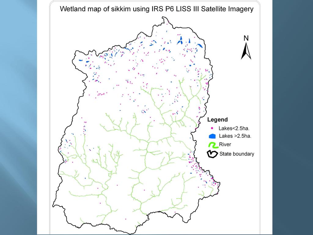
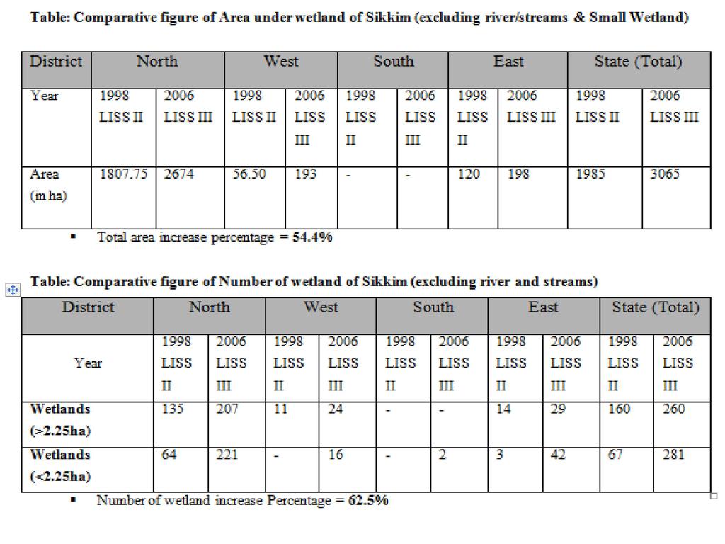
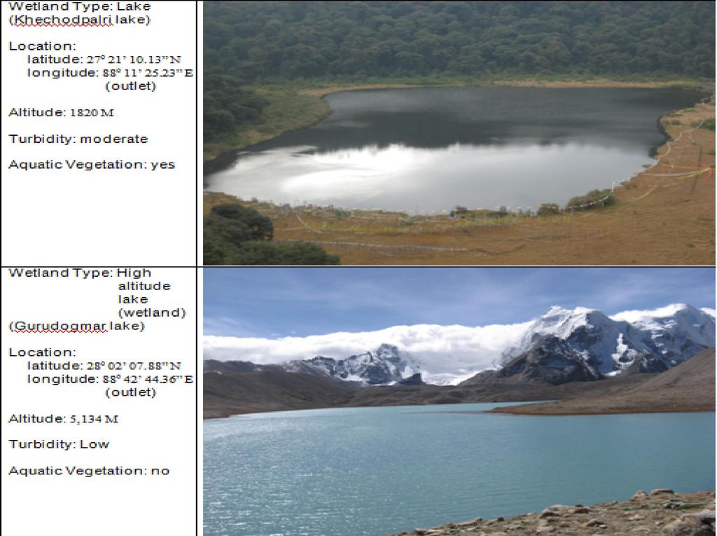
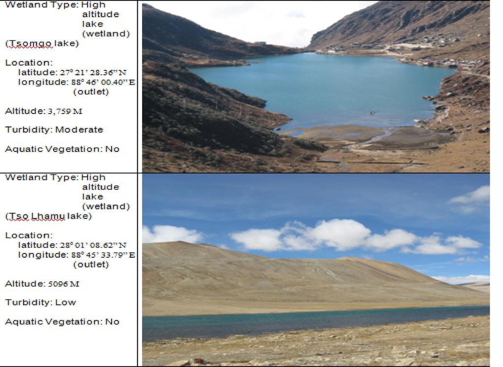
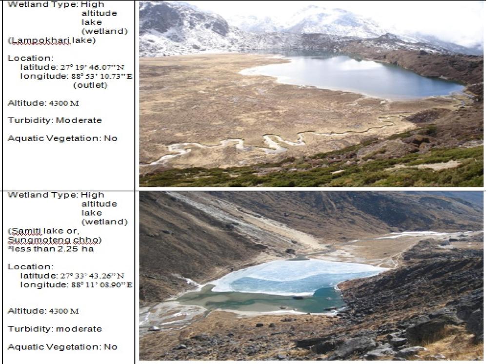
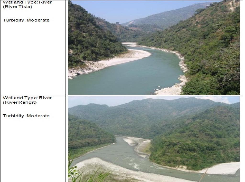
3 SIKKIM 22nd state of the Indian Union North Eastern region of India. Shares border with Nepal, China, Bhutan and West Bengal N to N latitudes and to E longitudes. The total geographic area of the state is 7,096 km % of the total geographical area of the country. Numerous snow-fed streams has carved out river valleys These streams combine into the Teesta and its tributaries. Main drainage basins: Teesta and Rangeet. The Teesta, described as the "lifeline of Sikkim", flows north to south There are 84 glaciers mapped in Sikkim. Numerous high altitude lakes in entire state. The premier lakes are Changu (Tsomgo), Khechodpalri, Gurudongmar, Cholamu, Memencho, Lampokhari, Samiti etc.
4


5 OBJECTIVES Mapping the wetlands of Sikkim using IRS LISS III digital data following a standard wetland classification system. Integration of ancillary theme layers (road, settlements, drainage, administrative boundaries). Creation of a seamless database in GIS environment. Comparative study of wetland with Wetlands of India - An Atlas of Sikkim (1998).
 from satellite image and ancillary data.")
6 METHODOLOGY Generation of spatial framework in GIS environment for database creation and organization Geo-referencing of satellite data Identification of wetland classes as per the knowledge based digital classification and onscreen interpretation Generation of base layers (road network, settlements, drainage, administrative boundaries) from satellite image and ancillary data. Attribute coding of the wetlands following the standard classification system and codification. Preparation of map compositions and generation of statistics
7 Work was carried out using ERDAS Imagine, Arc/Info and ArcGIS software. The widely used classification system, devised by Cowardin et al., (1979), was used during the study. The methodology was adhered to National Wetland Inventory and Assessment, technical guidelines and procedure manual (Garg and Patel, 2007). Data used: IRS P6 LISS III Pre-Monsoon (April 13, 2005); IRS P6 LISS III Post-Monsoon (January 26, 2006) and Topographic map of Sikkim (1:50,000 scale) The satellite data were registered by image-image registration process with acceptable RMS (Root Mean Square) error of 0.76 using ERDAS Imagine 9.1 software.

8 Flow chart of the methodology


9 RED GREEN NIR RED GREEN NIR SWIR Various land features as they appear in four spectral bands & in a typical 3 band FCC
10 ACCURACY ASSESSMENT Determination of thematic classification as well as location accuracy Database evaluated for accuracy and to ensure reliability of data Quality assurance and quality control measures were taken for data collection, analysis, verification and reporting The study has used well established, time-tested, fully documented data collection conventions All interpreted imagery was reviewed by technical expert for accuracy and code. Quality check includes: 1. Image to image Geo-referencing/Data generation. 2. Wetland mapping using visual/digital interpretation techniques. 3. Geo-data base creation and organization. 4. Output products.
11


12 Gurudogmar lake Cholamu lake Aqua-veg Khechodpalri lake IRS P6 LISS III imagery of Sikkim
13
14
15
16
17
18
19
20
21 ACKNOWLEDGEMENTS The authors greatly acknowledge all officers and staffs of Department of Science and Technology and Climate Change, Government of Sikkim and all the Scientists and staff of Space Application Centre (ISRO), Ahmedabad The encouragement received from Shri G. Madhavan Nair, Chairman, Indian Space Research Organization (ISRO), Bangalore is thankfully acknowledged. We thank Dr. (Smt.) Susma Panigrahy, Group Director, Agriculture, Forestry and Environment group for her support, guidance, interest and critical inputs. Our special thanks goes to Dr. Sandeep Tambee (Special Secretary, RMDD, Govt. of Sikkim), Mr. Nima Bhutia (TMI) and Mr. Laku Bhutia (Himal Raksak) for providing us photographs of high-altitude lake (wetland).
22 REFERENCES: Cowardin, L.M., Carter, V., Golet, E.C. and La Roe (1979). Classification of wetlands and deep water habitats. USFWS/085-79/31, Office of the Biological Services, U.S. Fish and Wildlife Service, Washington, D.C. Garg J.K. and Patel J. G., National Wetland Inventory and Assessment, Technical Guidelines and Procedure Manual, Technical Report, SAC/EOAM/AFEG/NWIA/TR/01/2007, June 2007, Space Applications Centre, Ahmedabad, Garg, J.K., Singh, T.S. and Murthy, T.V.R. (1998). Wetlands of India. Project Report: RSAM/sac/resa/pr/01/98, June 1998, 240 p. Space Applications Centre, Ahmedabad, Lillesand, T.M. and Keifer, R.W Remote Sensing and Image Interpretation. John Wliey and Sons, New York. Manorama Yearbook 2007 Millennium Ecosystem Assessment. 2005, Ecosystems and Human Well-being: A Framework for Assessment, Navalgund, R.R., Nayak, S.R., Sudarshana, R., Nagaraja, R. and Ravindran, S Proceedings of the ISPRS Commission VII. Symposium on Resource and Environmental Monitoring, IAPRS & SIS, Vol.35, Part-7, NRSA, Hyderabad. Risley, H. H. 2001, The Gazetteer of Sikkim Verma, Rajesh, Sikkim Guide
23 THANK YOU
STUDY ON TYPE AND DISTRIBUTION OF WETLANDS OF SIKKIM HIMALAYAS USING SATELLITE IMAGERY WITH REMOTE SENSING & GIS TECHNIQUE
 STUDY ON TYPE AND DISTRIBUTION OF WETLANDS OF SIKKIM HIMALAYAS USING SATELLITE IMAGERY WITH REMOTE SENSING & GIS TECHNIQUE Narpati Sharma*, Safal Pradhan, M. L. Arrawatia and D.G. Shrestha Department of
7.1 INTRODUCTION 7.2 OBJECTIVE
 7 LAND USE AND LAND COVER 7.1 INTRODUCTION The knowledge of land use and land cover is important for many planning and management activities as it is considered as an essential element for modeling and
NEEDS TO CONSERVE THE WETLAND RESOURCES FOR SUSTAINABLE DEVELOPMENT OF BELGAUM DISTRICT OF KARNATAKA: USING MULTISPECTRAL SATELLITE DATA
 Journal of Global Resources Volume 2 January 2016 Page 127-135 ISSN: 2395-3160 (Print), 2455-2445 (Online) 17 NEEDS TO CONSERVE THE WETLAND RESOURCES FOR SUSTAINABLE DEVELOPMENT OF BELGAUM DISTRICT OF
Environmental Impact Assessment Land Use and Land Cover CISMHE 7.1 INTRODUCTION
 7 LAND USE AND LAND COVER 7.1 INTRODUCTION The knowledge of land use and land cover is important for many planning and management activities as it is considered an essential element for modeling and understanding
Land Use and Land Cover Mapping and Change Detection in Jind District of Haryana Using Multi-Temporal Satellite Data
 Land Use and Land Cover Mapping and Change Detection in Jind District of Haryana Using Multi-Temporal Satellite Data Ravindra Prawasi, M.P. Sharma, T. P. Babu, Om Pal, Saroj, Kirti Yadav, R.S.Hooda Abstract
Abstract. TECHNOFAME- A Journal of Multidisciplinary Advance Research. Vol.2 No. 2, (2013) Received: Feb.2013; Accepted Oct.
 Received: Feb.2013; Accepted Oct.") Vol.2 No. 2, 83-87 (2013) Received: Feb.2013; Accepted Oct. 2013 Landuse Pattern Analysis Using Remote Sensing: A Case Study of Morar Block, of Gwalior District, M.P. Subhash Thakur 1 Akhilesh Singh 2
Vol.2 No. 2, 83-87 (2013) Received: Feb.2013; Accepted Oct. 2013 Landuse Pattern Analysis Using Remote Sensing: A Case Study of Morar Block, of Gwalior District, M.P. Subhash Thakur 1 Akhilesh Singh 2
International Journal of Scientific & Engineering Research, Volume 6, Issue 7, July ISSN
 International Journal of Scientific & Engineering Research, Volume 6, Issue 7, July-2015 1428 Accuracy Assessment of Land Cover /Land Use Mapping Using Medium Resolution Satellite Imagery Paliwal M.C &.
UNITED NATIONS E/CONF.96/CRP. 5
 UNITED NATIONS E/CONF.96/CRP. 5 ECONOMIC AND SOCIAL COUNCIL Eighth United Nations Regional Cartographic Conference for the Americas New York, 27 June -1 July 2005 Item 5 of the provisional agenda* COUNTRY
ASTER DEM Based Studies for Geological and Geomorphological Investigation in and around Gola block, Ramgarh District, Jharkhand, India
 International Journal of Scientific & Engineering Research, Volume 3, Issue 2, February-2012 1 ASTER DEM Based Studies for Geological and Geomorphological Investigation in and around Gola block, Ramgarh
MAPPING LAND USE/ LAND COVER OF WEST GODAVARI DISTRICT USING NDVI TECHNIQUES AND GIS Anusha. B 1, Sridhar. P 2
 MAPPING LAND USE/ LAND COVER OF WEST GODAVARI DISTRICT USING NDVI TECHNIQUES AND GIS Anusha. B 1, Sridhar. P 2 1 M. Tech. Student, Department of Geoinformatics, SVECW, Bhimavaram, A.P, India 2 Assistant
Effect of land use/land cover changes on runoff in a river basin: a case study
 Water Resources Management VI 139 Effect of land use/land cover changes on runoff in a river basin: a case study J. Letha, B. Thulasidharan Nair & B. Amruth Chand College of Engineering, Trivandrum, Kerala,
Abstract: About the Author:
 REMOTE SENSING AND GIS IN LAND USE PLANNING Sathees kumar P 1, Nisha Radhakrishnan 2 1 1 Ph.D Research Scholar, Department of Civil Engineering, National Institute of Technology, Tiruchirappalli- 620015,
Civil Engineering Journal
 Available online at www.civilejournal.org Civil Engineering Journal Vol. 1, No. 2, December, 2015 Comparative Study of Landsat and Aster Data by Morphometric Analysis Sujit Kumar a*, Tapasi Bhandary b
International Journal of Scientific Research and Reviews
 Case Study Available online www.ijsrr.org ISSN: 2279 0543 International Journal of Scientific Research and Reviews Study on the Pattern of Land Use /Land Cover Change in Sonipat District of NCR, A Block
CHAPTER VII FULLY DISTRIBUTED RAINFALL-RUNOFF MODEL USING GIS
 80 CHAPTER VII FULLY DISTRIBUTED RAINFALL-RUNOFF MODEL USING GIS 7.1GENERAL This chapter is discussed in six parts. Introduction to Runoff estimation using fully Distributed model is discussed in first
CHANGES IN VIJAYAWADA CITY BY REMOTE SENSING AND GIS
 International Journal of Civil Engineering and Technology (IJCIET) Volume 8, Issue 5, May 2017, pp.217 223, Article ID: IJCIET_08_05_025 Available online at http://www.ia aeme.com/ijciet/issues.asp?jtype=ijciet&vtyp
Landuse and Landcover change analysis in Selaiyur village, Tambaram taluk, Chennai
 Landuse and Landcover change analysis in Selaiyur village, Tambaram taluk, Chennai K. Ilayaraja Department of Civil Engineering BIST, Bharath University Selaiyur, Chennai 73 ABSTRACT The synoptic picture
GROUNDWATER CONFIGURATION IN THE UPPER CATCHMENT OF MEGHADRIGEDDA RESERVOIR, VISAKHAPATNAM DISTRICT, ANDHRA PRADESH
 GROUNDWATER CONFIGURATION IN THE UPPER CATCHMENT OF MEGHADRIGEDDA RESERVOIR, VISAKHAPATNAM DISTRICT, ANDHRA PRADESH Prof.P.Jagadeesara Rao Department of Geo-Engineering and Centre for Remote Sensing, College
Indexing vulnerability of an embankment reach against breaching: A remote sensing and hydrodynamic based study
 European Water 60: 67-71, 2017. 2017 E.W. Publications Indexing vulnerability of an embankment reach against breaching: A remote sensing and hydrodynamic based study B. Talukdar *, A. Baid and R. Das Civil
Geography Class XI Fundamentals of Physical Geography Section A Total Periods : 140 Total Marks : 70. Periods Topic Subject Matter Geographical Skills
 Geography Class XI Fundamentals of Physical Geography Section A Total Periods : 140 Total Marks : 70 Sr. No. 01 Periods Topic Subject Matter Geographical Skills Nature and Scope Definition, nature, i)
INTERNATIONAL JOURNAL OF ENVIRONMENTAL SCIENCES Volume 5, No 1, Copyright by the authors - Licensee IPA- Under Creative Commons license 3.
 INTERNATIONAL JOURNAL OF ENVIRONMENTAL SCIENCES Volume 5, No 1, 2014 Copyright by the authors - Licensee IPA- Under Creative Commons license 3.0 Research article ISSN 0976 4402 Manual and automated delineation
Favorable potential zone map using Remote sensing and GIS
 Favorable potential zone map using Remote sensing and GIS M. Devarajan & S.Mohan GIS Cell, Hydrogeology Wing Tamilnadu Water Supply and Drainage Board, Chennai Abstract: TWAD Board is shouldering the responsibility
CHANGE DETECTION USING REMOTE SENSING- LAND COVER CHANGE ANALYSIS OF THE TEBA CATCHMENT IN SPAIN (A CASE STUDY)
") CHANGE DETECTION USING REMOTE SENSING- LAND COVER CHANGE ANALYSIS OF THE TEBA CATCHMENT IN SPAIN (A CASE STUDY) Sharda Singh, Professor & Programme Director CENTRE FOR GEO-INFORMATICS RESEARCH AND TRAINING
CHANGE DETECTION USING REMOTE SENSING- LAND COVER CHANGE ANALYSIS OF THE TEBA CATCHMENT IN SPAIN (A CASE STUDY) Sharda Singh, Professor & Programme Director CENTRE FOR GEO-INFORMATICS RESEARCH AND TRAINING
URBAN WATERSHED RUNOFF MODELING USING GEOSPATIAL TECHNIQUES
 URBAN WATERSHED RUNOFF MODELING USING GEOSPATIAL TECHNIQUES DST Sponsored Research Project (NRDMS Division) By Prof. M. GOPAL NAIK Professor & Chairman, Board of Studies Email: mgnaikc@gmail.com Department
Chitra Sood, R.M. Bhagat and Vaibhav Kalia Centre for Geo-informatics Research and Training, CSK HPKV, Palampur , HP, India
 APPLICATION OF SPACE TECHNOLOGY AND GIS FOR INVENTORYING, MONITORING & CONSERVATION OF MOUNTAIN BIODIVERSITY WITH SPECIAL REFERENCE TO MEDICINAL PLANTS Chitra Sood, R.M. Bhagat and Vaibhav Kalia Centre
FOREST RESEARCH INSTITUTE, DEHRADUN
 PROJECT REPORT DRAINAGE AND REPLENISHMENT STUDY OF MINED AREA OF GANGA SHYAMPUR RIVER HARIDWAR Submitted to UTTARAKHAND FOREST DEVELOPMENT CORPORATION (UFDC) 73, Nehru Road, Deharadun Prepared&Submitted
Plantations Mapping of Dabwali, Rania and Ellenabad blocks of Sirsa District Using on Screen Visual Interpretation Approach on WV-2 Data
 s Mapping of Dabwali, Rania and Ellenabad blocks of Sirsa District Using on Screen Visual Interpretation Approach on WV-2 Data Savita 1, Veena 2, Reetu Sharma 3 Haryana Space Applications Centre (HARSAC),
MONITORING OF SEASONAL SNOW COVER IN YAMUNA BASIN OF UTTARAKAHND HIMALAYA USING REMOTE SENSING TECHNIQUES
 MONITORING OF SEASONAL SNOW COVER IN YAMUNA BASIN OF UTTARAKAHND HIMALAYA USING REMOTE SENSING TECHNIQUES Anju Panwar, Devendra Singh Uttarakhand Space Application Centre, Dehradun, India ABSTRACT Himalaya
Shalaby, A. & Gad, A.
 Urban Sprawl Impact Assessment on the Fertile Agricultural Land of Egypt Using Remote Sensing and Digital Soil Database, Case study: Qalubiya Governorate Shalaby, A. & Gad, A. National Authority for Remote
Assessing state-wide biodiversity in the Florida Gap analysis project
 University of Nebraska - Lincoln DigitalCommons@University of Nebraska - Lincoln Nebraska Cooperative Fish & Wildlife Research Unit -- Staff Publications Nebraska Cooperative Fish & Wildlife Research Unit
Compact guides GISCO. Geographic information system of the Commission
 Compact guides GISCO Geographic information system of the Commission What is GISCO? GISCO, the Geographic Information System of the COmmission, is a permanent service of Eurostat that fulfils the requirements
Application of Remote Sensing Techniques for Change Detection in Land Use/ Land Cover of Ratnagiri District, Maharashtra
 IOSR Journal of Applied Geology and Geophysics (IOSR-JAGG) e-issn: 2321 0990, p-issn: 2321 0982.Volume 3, Issue 6 Ver. II (Nov. - Dec. 2015), PP 55-60 www.iosrjournals.org Application of Remote Sensing
Monitoring of Forest Cover Change in Sundarban mangrove forest using Remote sensing and GIS
 Monitoring of Forest Cover Change in Sundarban mangrove forest using Remote sensing and GIS By Mohammed Monirul Alam April 2008 Content 1: INTRODUCTION 2: OBJECTIVES 3: METHODOLOGY 4: RESULTS & DISCUSSION
Submitted to Central Coalfields Limited BHURKUNDA OCP, CCL
 Land Restoration / Reclamation Monitoring of Open Cast Coal Mines of Central Coalfields Limited producing less than 5 m cu m. (Coal+ OB) based on Satellite Data for the Year 2013 BHURKUNDA OCP, CCL Submitted
Hydrological parameters Controls Vulnerable Zones in Calicut Nilambur Gudalur Ghat section, Gudalur, The Nilgiris, Tamil Nadu.
 International Journal of ChemTech Research CODEN (USA): IJCRGG ISSN: 0974-4290 Vol.9, No.03 pp 248-253, 2016 Hydrological parameters Controls Vulnerable Zones in Calicut Nilambur Gudalur Ghat section,
Pierce Cedar Creek Institute GIS Development Final Report. Grand Valley State University
 Pierce Cedar Creek Institute GIS Development Final Report Grand Valley State University Major Goals of Project The two primary goals of the project were to provide Matt VanPortfliet, GVSU student, the
International Journal of Intellectual Advancements and Research in Engineering Computations
 ISSN:2348-2079 Volume-5 Issue-2 International Journal of Intellectual Advancements and Research in Engineering Computations Agricultural land investigation and change detection in Coimbatore district by
INTERNATIONAL JOURNAL OF GEOMATICS AND GEOSCIENCES Volume 6, No 2, 2015
 INTERNATIONAL JOURNAL OF GEOMATICS AND GEOSCIENCES Volume 6, No 2, 2015 Copyright by the authors - Licensee IPA- Under Creative Commons license 3.0 Research article ISSN 0976 4380 An Analysis of Land use
M.C.PALIWAL. Department of Civil Engineering NATIONAL INSTITUTE OF TECHNICAL TEACHERS TRAINING & RESEARCH, BHOPAL (M.P.), INDIA
, INDIA") INVESTIGATIONS ON THE ACCURACY ASPECTS IN THE LAND USE/LAND COVER MAPPING USING REMOTE SENSING SATELLITE IMAGERY By M.C.PALIWAL Department of Civil Engineering NATIONAL INSTITUTE OF TECHNICAL TEACHERS
INVESTIGATIONS ON THE ACCURACY ASPECTS IN THE LAND USE/LAND COVER MAPPING USING REMOTE SENSING SATELLITE IMAGERY By M.C.PALIWAL Department of Civil Engineering NATIONAL INSTITUTE OF TECHNICAL TEACHERS
A GIS approach to generation of thematic maps to monitor tea plantations: A case study
 Two and a Bud 59(2):41-45, 2012 RESEARCH PAPER. A GIS approach to generation of thematic maps to monitor tea plantations: A case study Minerva Saiki a I and R.M. Bhagat Department of Soils, Tocklai Experimental
Review Using the Geographical Information System and Remote Sensing Techniques for Soil Erosion Assessment
 Polish J. of Environ. Stud. Vol. 19, No. 5 (2010), 881-886 Review Using the Geographical Information System and Remote Sensing Techniques for Soil Erosion Assessment Nuket Benzer* Landscape Architecture
A Case Study of Using Remote Sensing Data and GIS for Land Management; Catalca Region
 A Case Study of Using Remote Sensing Data and GIS for Land Management; Catalca Region Dr. Nebiye MUSAOGLU, Dr. Sinasi KAYA, Dr. Dursun Z. SEKER and Dr. Cigdem GOKSEL, Turkey Key words: Satellite data,
Hydrologic Modelling of the Upper Malaprabha Catchment using ArcView SWAT
 Hydrologic Modelling of the Upper Malaprabha Catchment using ArcView SWAT Technical briefs are short summaries of the models used in the project aimed at nontechnical readers. The aim of the PES India
Wetlands and Riparian Mapping Framework Technical Meeting
 Wetlands and Riparian Mapping Framework Technical Meeting Meghan Burns Landscape Ecologist Linda Vance Senior Ecologist Why wetland and riparian mapping? Preliminary site assessment for the presence of
INTERNATIONAL JOURNAL OF GEOMATICS AND GEOSCIENCES Volume 2, No 1, 2011
 INTERNATIONAL JOURNAL OF GEOMATICS AND GEOSCIENCES Volume 2, No 1, 2011 Copyright 2010 All rights reserved Integrated Publishing services Research article ISSN 0976 4380 Spatio-Temporal changes of Land
PROANA A USEFUL SOFTWARE FOR TERRAIN ANALYSIS AND GEOENVIRONMENTAL APPLICATIONS STUDY CASE ON THE GEODYNAMIC EVOLUTION OF ARGOLIS PENINSULA, GREECE.
 PROANA A USEFUL SOFTWARE FOR TERRAIN ANALYSIS AND GEOENVIRONMENTAL APPLICATIONS STUDY CASE ON THE GEODYNAMIC EVOLUTION OF ARGOLIS PENINSULA, GREECE. Spyridoula Vassilopoulou * Institute of Cartography
Fish Pond. Old Secretariate. Shaheed Smarak
 Fish Pond Old Secretariate Shaheed Smarak HOW SATELLITE SCANS EARTH. Rajbhawan area viewed by IKONOS 1 meter sensor Very high resolution (40 cm) Orbi-Image data Higher the resolution better the geometric
Land Use / Land Cover Mapping in
 Land Use / Land Cover Mapping in Eastern and Southern African Regions RCMRD Experience by 6/24/2013, Nairobi Kenya Dr. Tesfaye Korme Director of RS, GIS and Mapping, RCMRD I. About RCMRD, Its Vision and
Ground Water Potential Mapping in Chinnar Watershed (Koneri Sub Watershed) Using Remote Sensing & GIS
 Using Remote Sensing & GIS") Ground Water Potential Mapping in Chinnar Watershed (Koneri Sub Watershed) Using Remote Sensing & GIS T.Velmurugan 1 Dr.D.Srinivasan 2 1 Assistant professor/civil, Roever Engineering College, Perambalur.
Ground Water Potential Mapping in Chinnar Watershed (Koneri Sub Watershed) Using Remote Sensing & GIS T.Velmurugan 1 Dr.D.Srinivasan 2 1 Assistant professor/civil, Roever Engineering College, Perambalur.
Land Accounts - The Canadian Experience
 Land Accounts - The Canadian Experience Development of a Geospatial database to measure the effect of human activity on the environment Who is doing Land Accounts Statistics Canada (national) Component
Thematic Mapping in Siwani Area, District Bhiwani using Remote Sensing and Gis
 International Journal of Research in Geography (IJRG) Volume 3, Issue 2, 2017, PP 12-17 ISSN 2454-8685 (Online) DOI: http://dx.doi.org/10.20431/2454-8685.0302002 www.arcjournals.org Thematic Mapping in
Accuracy Assessment of Land Cover Classification in Jodhpur City Using Remote Sensing and GIS
 Accuracy Assessment of Land Cover Classification in Jodhpur City Using Remote Sensing and GIS S.L. Borana 1, S.K.Yadav 1 Scientist, RSG, DL, Jodhpur, Rajasthan, India 1 Abstract: A This study examines
Distinct landscape features with important biologic, hydrologic, geomorphic, and biogeochemical functions.
 1 Distinct landscape features with important biologic, hydrologic, geomorphic, and biogeochemical functions. Have distinguishing characteristics that include low slopes, well drained soils, intermittent
LAND COVER CHANGES IN ROMANIA BASED ON CORINE LAND COVER INVENTORY
 LAND COVER CHANGES IN ROMANIA BASED ON CORINE LAND COVER INVENTORY 1990 2012 JENICĂ HANGANU, ADRIAN CONSTANTINESCU * Key-words: CORINE Land Cover inventory, Land cover changes, GIS. Abstract. From 1990
This is trial version
 Journal of Rangeland Science, 2012, Vol. 2, No. 2 J. Barkhordari and T. Vardanian/ 459 Contents available at ISC and SID Journal homepage: www.rangeland.ir Full Paper Article: Using Post-Classification
Application of Geographical Information System (GIS) tools in watershed analysis
 tools in watershed analysis") Application of Geographical Information System (GIS) tools in watershed analysis Paritosh Gupta 1, Damanjit S Minhas 2, Rajendra M Tamhane 1, A K Mookerjee 2 1.ESRI India New Delhi 2. LEA Associates South
Application of Geographical Information System (GIS) tools in watershed analysis Paritosh Gupta 1, Damanjit S Minhas 2, Rajendra M Tamhane 1, A K Mookerjee 2 1.ESRI India New Delhi 2. LEA Associates South
Word Limit of the Paper should not be more than 3000 Words = 7/8 Pages) Abstract: About the Author:
 Abstract: About the Author:") Assessment of Land Use/ Land Cover Changes and Its Impact on Wetland Ecosystem of Loktak Lake using Remote Sensing and GIS Techniques A Ramsar Site in Indo Burma Biodiversity Hotspot Rajiv Das Kangabam,
Assessment of Land Use/ Land Cover Changes and Its Impact on Wetland Ecosystem of Loktak Lake using Remote Sensing and GIS Techniques A Ramsar Site in Indo Burma Biodiversity Hotspot Rajiv Das Kangabam,
SECTION 1: Identification Information
 Page 1 of 6 Home Data Catalog Download Data Data Status Web Services About FAQ Contact Us SECTION 1: Identification Information Originator: Minnesota DNR - Division of Forestry Title: GAP Land Cover -
Outline. Remote Sensing, GIS and DEM Applications for Flood Monitoring. Introduction. Satellites and their Sensors used for Flood Mapping
 Outline Remote Sensing, GIS and DEM Applications for Flood Monitoring Prof. D. Nagesh Kumar Chairman, Centre for Earth Sciences Professor, Dept. of Civil Engg. Indian Institute of Science Bangalore 560
Determination of flood risks in the yeniçiftlik stream basin by using remote sensing and GIS techniques
 Determination of flood risks in the yeniçiftlik stream basin by using remote sensing and GIS techniques İrfan Akar University of Atatürk, Institute of Social Sciences, Erzurum, Turkey D. Maktav & C. Uysal
DATA INTEGRATION FOR PAN EUROPEAN LAND COVER MONITORING. Victor van KATWIJK Geodan IT
 DATA INTEGRATION FOR PAN EUROPEAN LAND COVER MONITORING Victor van KATWIJK Geodan IT victor@geodan.nl Wideke BOERSMA CSO, The Netherlands w.boersma@bunnik.cso.nl Sander MÜCHER Alterra, the Netherlands
International Journal of Research in Advent Technology, Vol.2, No.10, October 2014 E-ISSN:
 Monitoring of Land Use Land Cover Change over the Years Due to River Course Shifting: A Case Study on Ganga River Basin near Malda District, West Bengal Using Geo-informatices Techniques Somnath maiti
This Week s Topics. GIS and Forest Engineering Applications. FE 257. GIS and Forest Engineering Applications. Instructor Information.
 FE 257. GIS and Forest Engineering Applications Introduction Instructor Information Associate Professor in FERM Department Instructor for FE 257, FE 480, FE 432/532 PhD from Forest Resources with minor
Assessing Michigan s Biological diversity. Michigan Natural Features Inventory MSU Extension
 Assessing Michigan s Biological diversity John Paskus,, Amy Derosier,, Edward Schools, and Helen Enander Michigan Natural Features Inventory MSU Extension Goal Provide scientifically based information
Overview of Remote Sensing in Natural Resources Mapping
 Overview of Remote Sensing in Natural Resources Mapping What is remote sensing? Why remote sensing? Examples of remote sensing in natural resources mapping Class goals What is Remote Sensing A remote sensing
Short Term Course GEOINFORMATION SCIENCE AND TECHNOLOGY REMOTE SENSING, GPS, & GIS APPLICATIONS. Duration: 20 Weeks Two Batches in an year
 Short Term Course on GEOINFORMATION SCIENCE AND TECHNOLOGY REMOTE SENSING, GPS, & GIS APPLICATIONS Duration: 20 Weeks Two Batches in an year Information Brochure Dr. R. Satheesh Centre for Remote Sensing
Required Documents. Title: Number: AEP Administration 2017 No. 1. Provincial Wetlands and Water Boundaries Section. Effective Date: September 1, 2017
 Title: Number: Program Name: Provincial Wetlands and Water Boundaries Section Effective Date: September 1, 2017 This document was updated on: August 25, 2017 The Provincial Wetlands and Water Boundaries
Geomorphological Analysis of Aralamallige Watershed, Bangalore Using Remote Sensing and GIS Approach
 International Journal of Research Studies in Biosciences (IJRSB) Volume 2, Issue 1, February 2014, PP 6-10 www.arcjournals.org Geomorphological Analysis of Aralamallige Watershed, Bangalore Using Remote
Digital Change Detection Using Remotely Sensed Data for Monitoring Green Space Destruction in Tabriz
 Int. J. Environ. Res. 1 (1): 35-41, Winter 2007 ISSN:1735-6865 Graduate Faculty of Environment University of Tehran Digital Change Detection Using Remotely Sensed Data for Monitoring Green Space Destruction
ENV208/ENV508 Applied GIS. Week 1: What is GIS?
 ENV208/ENV508 Applied GIS Week 1: What is GIS? 1 WHAT IS GIS? A GIS integrates hardware, software, and data for capturing, managing, analyzing, and displaying all forms of geographically referenced information.
Educational Qualification No ( No of Positions) 01. Geographic
 01. Geographic") ICZMP, State Project Management Unit-Orissa Plot # 108,Unit VII, Suryanagar,Bhubaneswar 751 003 ICZMP invites applications from eligible candidates for filling up of posts as mentioned below under the
ICZMP, State Project Management Unit-Orissa Plot # 108,Unit VII, Suryanagar,Bhubaneswar 751 003 ICZMP invites applications from eligible candidates for filling up of posts as mentioned below under the
Regional Centre for Mapping of Resources for Development (RCMRD), Nairobi, Kenya
, Nairobi, Kenya") Regional Centre for Mapping of Resources for Development (RCMRD), Nairobi, Kenya Introduction to GIS (2 weeks: 10 days) Intakes: 8 th January, 6 th February, 5th March, 3 rd. April 9 th, May 7 th, June
Regional Centre for Mapping of Resources for Development (RCMRD), Nairobi, Kenya Introduction to GIS (2 weeks: 10 days) Intakes: 8 th January, 6 th February, 5th March, 3 rd. April 9 th, May 7 th, June
GIS AS A TOOL FOR MINERAL EXPLORATION
 GIS AS A TOOL FOR MINERAL EXPLORATION By Njagi Dennis Muriithi I13/3169/2008 SGL 413: PROJECT IN GEOLOGY Course coordinators: Dr. C. M. Gichaba Dr. E. Dindi Supervisor: Dr. C. M. Gichaba OUTLINE Introduction
Geospatial Information for Urban Sprawl Planning and Policies Implementation in Developing Country s NCR Region: A Study of NOIDA City, India
 Geospatial Information for Urban Sprawl Planning and Policies Implementation in Developing Country s NCR Region: A Study of NOIDA City, India Dr. Madan Mohan Assistant Professor & Principal Investigator,
Submitted to: Central Coalfields Limited Ranchi, Jharkhand. Ashoka & Piparwar OCPs, CCL
 Land Restoration / Reclamation Monitoring of more than 5 million cu. m. (Coal + OB) Capacity Open Cast Coal Mines of Central Coalfields Limited Based on Satellite Data for the Year 2013 Ashoka & Piparwar
Remote Sensing and GIS Application in Change Detection Study Using Multi Temporal Satellite
 Cloud Publications International Journal of Advanced Remote Sensing and GIS 2013, Volume 2, Issue 1, pp. 374-378, Article ID Tech-181 ISSN 2320-0243 Case Study Open Access Remote Sensing and GIS Application
79 International Journal of Scientific & Engineering Research, Volume 4, Issue 12, December-2013 ISSN
 79 International Journal of Scientific & Engineering Research, Volume 4, Issue 12, December-2013 Approach to Assessment tor RS Image Classification Techniques Pravada S. Bharatkar1 and Rahila Patel1 ABSTRACT
Landuse Pattern Analysis Using Remote Sensing: A Case Study of Mau District, India
 Available online at www.scholarsresearchlibrary.com Archives of Applied Science Research, 2011, 3 (5):10-16 (http://scholarsresearchlibrary.com/archive.html) ISSN 0975-508X CODEN (USA) AASRC9 Landuse Pattern
Landuse/Landcover Change Detection in Umshing- Mawkynroh of East Khasi Hills District, Meghalaya Using Spatial Information Technology
 International Journal of Scientific and Research Publications, Volume 6, Issue 1, January 2016 197 Landuse/Landcover Change Detection in Umshing- Mawkynroh of East Khasi Hills District, Meghalaya Using
Wetland Mapping. Wetland Mapping in the United States. State Wetland Losses 53% in Lower US. Matthew J. Gray University of Tennessee
 Wetland Mapping Caribbean Matthew J. Gray University of Tennessee Wetland Mapping in the United States Shaw and Fredine (1956) National Wetlands Inventory U.S. Fish and Wildlife Service is the principle
Change Detection in Landuse and landcover using Remote Sensing and GIS Techniques
 Change Detection in Landuse and landcover using Remote Sensing and GIS Techniques VEMU SREENIVASULU* and PINNAMANENI UDAYA BHASKAR Department of Civil Engineering Jawaharlal Nehru Technological University:
Yanbo Huang and Guy Fipps, P.E. 2. August 25, 2006
 Landsat Satellite Multi-Spectral Image Classification of Land Cover Change for GIS-Based Urbanization Analysis in Irrigation Districts: Evaluation in Low Rio Grande Valley 1 by Yanbo Huang and Guy Fipps,
Vegetation Change Detection of Central part of Nepal using Landsat TM
 Vegetation Change Detection of Central part of Nepal using Landsat TM Kalpana G. Bastakoti Department of Geography, University of Calgary, kalpanagb@gmail.com Abstract This paper presents a study of detecting
Geographical location and climatic condition of the
 Geographical location and climatic condition of the study sites North eastern region of India is comprised of eight states namely; Arunachal Pradesh, Assam, Manipur, Meghalaya, Mizoram, Nagaland, Sikkim
International Journal of Scientific & Engineering Research, Volume 6, Issue 11, November ISSN
 International Journal of Scientific & Engineering Research, Volume 6, Issue 11, November-2015 42 Geospatial Mapping of Fish Farms in Anambra State Using GIS Approach Ojiako, J.C., Okafor, C. M., Igbokwe,
Kyoto and Carbon Initiative - the Ramsar / Wetlands International perspective
 Kyoto and Carbon Initiative - the Ramsar / Wetlands International perspective (the thoughts of Max Finlayson, as interpreted by John Lowry) Broad Requirements Guideline(s) for delineating wetlands (specifically,
Journal of Telecommunications System & Management
 njournal of Telecommunicatio s System & Management Journal of Telecommunications System & Management Kota et al., J Telecommun Syst Manage 2017, 6:1 DOI: 10.4172/2167-0919.1000148 Research Article OMICS
GEOGRAPHY (029) CLASS XI ( ) Part A: Fundamentals of Physical Geography. Map and Diagram 5. Part B India-Physical Environment 35 Marks
 CLASS XI ( ) Part A: Fundamentals of Physical Geography. Map and Diagram 5. Part B India-Physical Environment 35 Marks") GEOGRAPHY (029) CLASS XI (207-8) One Theory Paper 70 Marks 3 Hours Part A Fundamentals of Physical Geography 35 Marks Unit-: Geography as a discipline Unit-3: Landforms Unit-4: Climate Unit-5: Water (Oceans)
GEOGRAPHY (029) CLASS XI (207-8) One Theory Paper 70 Marks 3 Hours Part A Fundamentals of Physical Geography 35 Marks Unit-: Geography as a discipline Unit-3: Landforms Unit-4: Climate Unit-5: Water (Oceans)
Technical Drafting, Geographic Information Systems and Computer- Based Cartography
 Technical Drafting, Geographic Information Systems and Computer- Based Cartography Project-Specific and Regional Resource Mapping Services Geographic Information Systems - Spatial Analysis Terrestrial
ASSESSMENT OF RESERVOIR SEDIMENTATION USING REMOTE SENSING SATELLITE IMAGERIES
 ASSESSMENT OF RESERVOIR SEDIMENTATION USING REMOTE SENSING SATELLITE IMAGERIES Kamuju Narasayya S. Narasaiah U C Roman Assistant Research Officer Research Officer Senior Research Officer Central Water
Generation and analysis of Digital Elevation Model (DEM) using Worldview-2 stereo-pair images of Gurgaon district: A geospatial approach
 using Worldview-2 stereo-pair images of Gurgaon district: A geospatial approach") 186 Generation and analysis of Digital Elevation Model (DEM) using Worldview-2 stereo-pair images of Gurgaon district: A geospatial approach Arsad Khan 1, Sultan Singh 2 and Kaptan Singh 2 1 Department
186 Generation and analysis of Digital Elevation Model (DEM) using Worldview-2 stereo-pair images of Gurgaon district: A geospatial approach Arsad Khan 1, Sultan Singh 2 and Kaptan Singh 2 1 Department
GEOMATICS. Shaping our world. A company of
 GEOMATICS Shaping our world A company of OUR EXPERTISE Geomatics Geomatics plays a mayor role in hydropower, land and water resources, urban development, transport & mobility, renewable energy, and infrastructure
Use of Corona, Landsat TM, Spot 5 images to assess 40 years of land use/cover changes in Cavusbasi
 New Strategies for European Remote Sensing, Olui (ed.) 2005 Millpress, Rotterdam, ISBN 90 5966 003 X Use of Corona, Landsat TM, Spot 5 images to assess 40 years of land use/cover changes in Cavusbasi N.
Current Status of the Standardization of Geographical Names in Cambodia
 1 Current Status of the Standardization of Geographical Names in Cambodia His Excellency Ith Sotha, Under Secretary of States, MLMUPC Mr Chharom Chin, Deputy Director, Geography Department, MLMUPC Mr Narith
International Journal of Scientific & Engineering Research, Volume 3, Issue 11, November ISSN
 International Journal of Scientific & Engineering Research, Volume 3, Issue 11, November-2012 1 ABSTRACT Land use land cover change detection of Ghatkesar mandal,rangareddy district using Remote sensing
Land Administration and Cadastre
 Geomatics play a major role in hydropower, land and water resources and other infrastructure projects. Lahmeyer International s (LI) worldwide projects require a wide range of approaches to the integration
Improvement of the National Hydrography Dataset for Parts of the Lower Colorado Region and Additional Areas of Importance to the DLCC
 Improvement of the National Hydrography Dataset for Parts of the Lower Colorado Region and Additional Areas of Importance to the DLCC Carlos Reyes-Andrade California State University, Northridge September
Distribution of Barren Salt-Affected Land in Gomati River Basin, Indo-Gangetic Plain, India, using Remote Sensing and GIS Techniques
 Distribution of Barren Salt-Affected Land in Gomati River Basin, Indo-Gangetic Plain, India, using Remote Sensing and GIS Techniques Manisha Mishra 1, Alok Mathur 2 & Dhruvsen Singh 3 Abstract The Indo-Gangetic
Inventory of Soil Resources of Dhalai District, Tripura State Using Remote Sensing and GIS Techniques
 Inventory of Soil Resources of Dhalai District, Tripura State Using Remote Sensing and GIS Techniques ABSTRACT. Survey : Dhalai District, Tripura 2. Geographical Extent : Between 23 o 24 to 24 o North
CONTINUOUS MAPPING OF THE ALQUEVA REGION OF PORTUGAL USING SATELLITE IMAGERY
 CONTINUOUS MAPPING OF THE ALQUEVA REGION OF PORTUGAL USING SATELLITE IMAGERY Célia Gouveia 1,2 and Carlos DaCamara 2 1 Escola Superior de Tecnologia, Instituto Politécnico de Setúbal, Setúbal. Portugal;