2015 Indiana GIS Professional Salary Survey DRAFT
|
|
|
- Kenneth Powell
- 5 years ago
- Views:
Transcription
1 2015 Indiana GIS Professional Salary Survey DRAFT August 25, 2015 Introduction In April, 2015, IGIC circulated the second Salary Survey to geospatial professionals around the state. Responses were collected online from a total of 221 individuals. Responses were provided to a total of 19 questions about salary, education, industry, technology, historical document use, and volunteerism. An analysis of the results is given below Average Salary Average Annual Salary: $55, Respondents: Average Salary (First IGIC Salary Survey) Average Annual Salary: $51, Respondents: Average Salary (% Increase) Percent Increase: 7.76% 1

2 Type of Organization 2015 Average Salary 2010 Average Salary # of Respondents County Government $44,092 $40, State Government 54,509 53, City Government 49,011 48, Private Sector 78,188 55, Utility 64,293 57, Institution/University 58,613 49, Other 51,860 61, Federal Government 77,250 58,663 6 Total 221 2
3 Private Sector Areas of Expertise Agriculture BioTech Civil Engineering Conservation Consulting Education Education non-profit Electrical Utilities Gas Geospatial/Geospatial Imagery GIS Services / GIS Sales Imagery, Base-map Data, Local Government Non-profit Other: Regional Planning Photogrammetric Mapping Regional / Regional Government Transportation From the data, 61% of the respondents are from government-related employment, while 29% are from private industry and 9% are from the post-secondary arena. Within the private sector, areas represented have expanded since the 2010 IGIC Salary Survey, which can be seen from the Job Titles & Average Salaries data below. 3


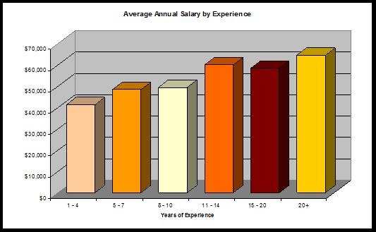
4 Years in GIS # of Respondents 10 to to to to to to or above 18 Total 220 4
 High School $43,347 15 = 5.7% Some College $42,931 10 = 3.")
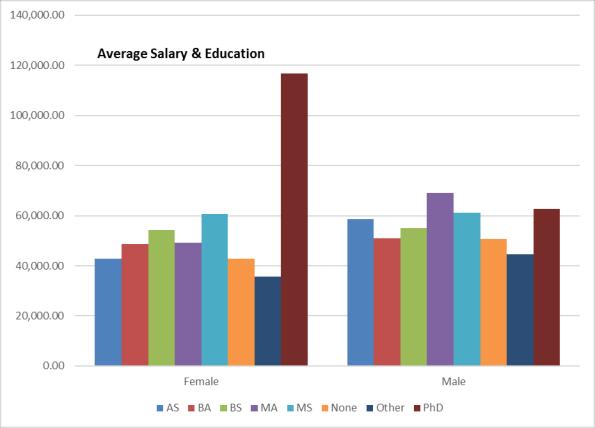
5 Educational Background Bachelor of Sciences 64 Master of Sciences 38 Associates 28 Bachelor of Arts 28 Master of Arts 23 None 19 Other (including GISP) 11 PhD 9 Total 220 # of Respondents FYI 2010 Education Average Annual Salary Count (of 263 Respondents) High School $43, = 5.7% Some College $42, = 3.8% Associate s Degree $49, = 14% Bachelor s Degree $50, = 45% Some Graduate $58,280 4 Master s Degree $56, = 25% PhD $60,593 7 = 2.6% Professional Certification $36,000 3 = 1% 5
6 $90,000 $80, Average Salary & Years of Experience Male Female 40 # Respondents 35 $70, $60,000 $50,000 $40,000 $30, $20,000 $10,000 $ yrs. experience FYI 2010 Years of Experience in GIS Avg. Annual Salary # Respondents 1-4 $41, $48, $49, $60, $58, $64,
7 7

8 FYI
9 2015 Job Titles & Average Salaries FYI 2010 Salary Survey Job Title Avg. Salary # Intern 34,250 2 Emergency Manager 40,624 3 Cartographer 40,890 5 CAD Technician/Manager 42,667 3 GIS Technician 43, Planner 43,917 6 Surveying 44,550 7 GIS Specialist 45, GIS Supervisor 47,000 3 Environmental 47, GIS Coordinator 47, Data Manager 49,800 5 GIS Analyst 49, GIS Administrator 50,600 3 Support Staff 50,767 3 GIS Director 53,

10 2015 Average Salaries by Geographic Regions FYI 2010 Data Region Avg. Annual Salary # Responses North $47, North Central 47, Central 55, South Central 39,560 5 South 49, Data Region Avg. Annual Salary # Responses North $49, North Central 59, Central 58, South Central 47,

11 11

12 12
13 13
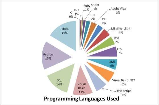
14 A shift from 2010 programming languages has occurred from SQL, Python, HTML at the top three. Python is considered by post-secondary specialists to be the up and coming programming language for geospatial technologies along with R, a statistics/probability software. 14
15 15

16 16
17 17
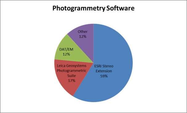
18 GIS Professional Salary Survey August 25, 2015 FYI 2010 Technology Use for more detailed data, see the IGIC website for the 2010 Salary Survey Report 1. GIS Software ESRI Products (ArcGIS, View, INFO, Editor, SDE, Server, Pad, Map, IMS, Catalog) Google Earth/Map AutoDesk Products (Map, MapGuide & other) Microsoft Bing Map/3D Bentley Products (Map & other) GlobalMapper MapInfo DDTI Accuglobe 2. GPS Technology Trimble Garmin Pathfinder Magellan TruView Think Map 6. Photogrammetry Software Leica Geosystems Photogrammetric Suite ESRI Stereo Extension Intergraph Z/I Imaging 7. LiDAR LizardTech LiDAR Compressor QCoherent Software Other Virtual Geomatics VG4D TerraSolid LiDAR Products Trimble LiDAR Analyst 8. Remote Sensing / Image Processing Software 3. Database Software Microsoft Access Microsoft SQL Server Oracle dbase MySQL 4. Programming Technologies top 5 SQL Python HTML VBA Microsoft.NET 5. CAD Software AutoDesk AutoCAD Bentley MicroStation TurboCAD Adobe Photoshop Pictometry Viewer ERDAS Imagine LizardTech Compressor Suite Other ER Mapper ITT EXVI EX DeLorme TopoBird Idrisi PCI Geomatics Geomatica Microsoft Paint ERDAS APOLLO GIMP GenaMap ITT ENVI Surfer Manifold Map Guide MultiSpec IrfanView Unspecified 18
19 Question 18: Do you volunteer at area schools, 4-H, FFA, Scouts or other groups to teach about GIS/geospatial technologies? Yes or No 83% responded No 17% responded Yes You are accomplishing amazing things through your outreach and engagement! Of those who responded yes, the majority are working with K-12 students either through classroom work, 4-H, FFA, Boy Scouts, and GIS Day activities. Generally, you are engaging when directly asked by a teacher (or your son/daughter ), Cub Scout Pack Leader, Boy Scout Troop Master/Student working on a Merit Badge, or 4-H/FFA Leader to demonstrate GPS/geocaching, aerial photography, map making/cartography, or remote sensing. Some of you speak before local groups such as the Rotary, Kiwanis, or Moose. Some of you are volunteering applied GIS for local places that need assistance: EMA efforts, animal shelter (mapping found cats/dogs), guest speakers in college classrooms, local community outreach events, and school boards/councils. Of those who responded yes, an average of 9.25 volunteer hours for the year were spent sharing geospatial technologies and perspectives. THANK YOU! Question 19: In your professional career, do you utilize historical data (10+ years old)? Yes or No 90 out of 223 responded Yes (40%) of total survey respondents use historical data Out of these 90: 6 use historical Census data 36 (40%) use historical aerial imagery/photography At least 17 (19%) use historical land, deed, property, plat, parcel, easement, and survey data 12 use other historical imagery 12 (13%) use Sanborn Maps 12 (13%) use other historical maps (Baist, USGS Topo, and other city and county maps) 8 use historical data from IndianaMap, Indiana Geological Survey, USGS, and USDA. 6 use historical tax, assessor, auditor, recorder, and trustee data 6 use historical orthophotography/imagery At least 5 use historical city planning and permit data 19
2015 Indiana GIS Professional Salary Survey
 2015 Indiana GIS Professional Salary Survey Introduction In April, 2015, IGIC circulated the second Salary Survey to geospatial professionals around the state. Responses were collected online from a total
SCAUG GIS Survey. GIS Manager % GIS Specialist % GIS Technician % GIS Coordinator % Analyst 16 9.
 Q1: Describe your current position: GIS Manager 25 14.71% GIS Specialist 25 14.71% GIS Technician 23 13.53% GIS Coordinator 19 11.18% Analyst 16 9.41% Senior GIS Analyst 11 6.47% Other 10 5.88% GIS Director
POSITION DESCRIPTION. Position Title: Geographic Information Systems (GIS) Coordinator Department: Engineering
 Coordinator Department: Engineering") POSITION DESCRIPTION Position Title: Geographic Information Systems (GIS) Coordinator Department: Engineering Reports To: Engineering Supervisor FLSA Status: Exempt Date: April 2018 PRIMARY OBJECTIVE OF
POSITION DESCRIPTION Position Title: Geographic Information Systems (GIS) Coordinator Department: Engineering Reports To: Engineering Supervisor FLSA Status: Exempt Date: April 2018 PRIMARY OBJECTIVE OF
Applications: Introduction Task 1: Introduction to ArcCatalog Task 2: Introduction to ArcMap Challenge Question References
 CHAPTER 1 INTRODUCTION 1.1 GIS? 1.1.1 Components of a GIS 1.1.2 A Brief History of GIS 1.1.3 GIS Software Products Box 1.1 A List of GIS Software Producers and Their Main Products 1.2 GIS Applications
GIS Certification: How will it be used to improve education?
 GIS Certification: How will it be used to improve education? Deidre Sullivan OSTO Workshop November 11, 2008 1 What is GIS? Geographic Information Systems It is a science, a tool, and a software It assists
CURRICULUM VITAE Mthobeli Vaaltyn
 CURRICULUM VITAE Mthobeli Vaaltyn 2880 Dwarhane Street Browns Farm Philippi 7785 Cell: 071 3720 456 E-Mail: mvaaltyn4@gmail.com PERSONAL DETAILS Surname First Name(s) : Vaaltyn : Mthobeli Date of Birth
LiDAR User Data Needs Survey Results
 LiDAR User Data Needs Survey Results June 2012 Introduction The Minnesota Geospatial Information Office (MnGeo) is working with the Minnesota Department of Natural Resources (DNR) to develop a data distribution
ANDREW MCMILLAN 888 West 18 th Avenue Vancouver, BC V5Z 1W3 Tel. (604) OBJECTIVE SUMMARY
 OBJECTIVE SUMMARY") ANDREW MCMILLAN 888 West 18 th Avenue Vancouver, BC V5Z 1W3 Tel. (604) 877-1802 Email: ajmcmillan@yahoo.ca OBJECTIVE To provide and manage IT, spatial solutions and web technologies using strong problem
ANDREW MCMILLAN 888 West 18 th Avenue Vancouver, BC V5Z 1W3 Tel. (604) 877-1802 Email: ajmcmillan@yahoo.ca OBJECTIVE To provide and manage IT, spatial solutions and web technologies using strong problem
Watershed Sciences 4930 & 6920 GEOGRAPHIC INFORMATION SYSTEMS
 Watershed Sciences 4930 & 6920 GEOGRAPHIC INFORMATION SYSTEMS WEEK ONE Lecture 2 GIS Review & Intro to WebGIS Joe Wheaton TODAY S PLAN I. Housekeeping II. Review of GIS III. Alternatives to ArcGIS IV.
Inception to Completion: The Project Design Workflow. Southwest User Group April 10, 2018 Broomfield, CO
 1 Inception to Completion: The Project Design Workflow Southwest User Group April 10, 2018 Broomfield, CO 2 Tools Trimble GPS Survey grade (S6) Mapping grade (6000) Trimble V10 imaging rover Trimble Business
John Laznik 273 Delaplane Ave Newark, DE (302)
") Office Address: John Laznik 273 Delaplane Ave Newark, DE 19711 (302) 831-0479 Center for Applied Demography and Survey Research College of Human Services, Education and Public Policy University of Delaware
Office Address: John Laznik 273 Delaplane Ave Newark, DE 19711 (302) 831-0479 Center for Applied Demography and Survey Research College of Human Services, Education and Public Policy University of Delaware
The Next Generation GIS/LIS A Surveys Information System Integrated within a GIS
 The Next Generation GIS/LIS A Surveys Information System Integrated within a GIS Michael F. WEIR, USA Key words: Linking, Snapping, GIS, Measurements, Measurement Data, GIS Features, Spatial Quality. SUMMARY
FIRE DEPARMENT SANTA CLARA COUNTY
 DEFINITION FIRE DEPARMENT SANTA CLARA COUNTY GEOGRAPHIC INFORMATION SYSTEM (GIS) ANALYST Under the direction of the Information Technology Officer, the GIS Analyst provides geo-spatial strategic planning,
Europass Curriculum Vitae
 Europass Curriculum Vitae Personal information First name(s) / Surname(s) Clinci Tudorel Silviu Address Valea Doftanei, Prahova county, 107640, Romania E-mail(s) tudorelsilviu@yahoo.com Nationality Romanian
Joanne N. Halls, PhD Dept. of Geography & Geology David Kirk Information Technology Services
 Joanne N. Halls, PhD Dept. of Geography & Geology David Kirk Information Technology Services Geographic Information Systems manage and analyze data to solve spatial problems. Real World Abstraction Analysis
Write a report (6-7 pages, double space) on some examples of Internet Applications. You can choose only ONE of the following application areas:
 on some examples of Internet Applications. You can choose only ONE of the following application areas:") UPR 6905 Internet GIS Homework 1 Yong Hong Guo September 9, 2008 Write a report (6-7 pages, double space) on some examples of Internet Applications. You can choose only ONE of the following application
UPR 6905 Internet GIS Homework 1 Yong Hong Guo September 9, 2008 Write a report (6-7 pages, double space) on some examples of Internet Applications. You can choose only ONE of the following application
GIS ADMINISTRATOR / WEB DEVELOPER EVANSVILLE-VANDERBURGH COUNTY AREA PLAN COMMISSION
 GIS ADMINISTRATOR / WEB DEVELOPER EVANSVILLE-VANDERBURGH COUNTY AREA PLAN COMMISSION SALARY RANGE INITIATION $43,277 SIX MONTHS $45,367 POSITION GRADE PAT VI The Evansville-Vanderburgh County Area Plan
John A. Ritter, Ph.D. Oregon Institute of Technology
 Oregon Institute of Technology Department t of Geomatics A GIS Degree That Merges GIS with Surveying Presented By Presented By John A. Ritter, Ph.D. Oregon Institute of Technology Presentation Objectives
USING LANDSAT IN A GIS WORLD
 USING LANDSAT IN A GIS WORLD RACHEL MK HEADLEY; PHD, PMP STEM LIAISON, ACADEMIC AFFAIRS BLACK HILLS STATE UNIVERSITY This material is based upon work supported by the National Science Foundation under
JOB DESCRI PTI ON. GIS Administrator
 JOB DESCRI PTI ON JOB GRADE: GS-0 Cla ss Code : Office - 8 8 0 DEPARTMENT: 2 0 - FLSA: EXEMPT JOB NO: 6-0 9-2 7 SALARY: To Be De t e rm in e d Job description statements are intended to describe the general
Geospatial Services in Special Libraries: A Needs Assessment Perspective
 Purdue University Purdue e-pubs Libraries Faculty and Staff Scholarship and Research Purdue Libraries 5-17-2013 Geospatial Services in Special Libraries: A Needs Assessment Perspective Ilana R. Barnes
Information. Information Technology. Geographic. Services (GIS) 119 W Indiana Ave Deland, FL 32720
 119 W Indiana Ave Deland, FL 32720") Information Technology Geographic Information Services (GIS) 119 W Indiana Ave Deland, FL 32720 A GIS consists of 5 primary components: Hardware Software People Data Methods or Business Processes --- Hardware
Information Technology Geographic Information Services (GIS) 119 W Indiana Ave Deland, FL 32720 A GIS consists of 5 primary components: Hardware Software People Data Methods or Business Processes --- Hardware
GIS Visualization: A Library s Pursuit Towards Creative and Innovative Research
 GIS Visualization: A Library s Pursuit Towards Creative and Innovative Research Justin B. Sorensen J. Willard Marriott Library University of Utah justin.sorensen@utah.edu Abstract As emerging technologies
Features and Benefits
 Autodesk LandXplorer Features and Benefits Use the Autodesk LandXplorer software family to help improve decision making, lower costs, view and share changes, and avoid the expense of creating physical
DIPLOMA IN GEOMATICS (NQF Level 6)
") DIPLOMA IN GEOMATICS ( 6) Programme Aims/Purpose: The Diploma in Geomatics programme was purposefully designed to prepare students for a career as survey technician, with specialised knowledge and skills
DIPLOMA IN GEOMATICS ( 6) Programme Aims/Purpose: The Diploma in Geomatics programme was purposefully designed to prepare students for a career as survey technician, with specialised knowledge and skills
Oakland County Parks and Recreation GIS Implementation Plan
 Oakland County Parks and Recreation GIS Implementation Plan TABLE OF CONTENTS 1.0 Introduction... 3 1.1 What is GIS? 1.2 Purpose 1.3 Background 2.0 Software... 4 2.1 ArcGIS Desktop 2.2 ArcGIS Explorer
Department of Geography
 Department of Geography University School of Sciences, Gujarat University, Navrangpura, Ahmedabad 380009. Phone : +91-79-27912832 Director Head I/C : Prof. M. V. RAO : MR. MAHESHKUMAR K. PATEL Brief History
GIS-T 2010 Building a Successful Geospatial Data Sharing Framework: A Ohio DOT Success Story
 GIS-T 2010 Building a Successful Geospatial Data Sharing Framework: A Ohio DOT Success Story ODOT District 2 GIS John Puente District 1 GIS Coordinator\ Planning Administrator 2 Interoperability 3 District
2010 NORTH TEXAS GIS TOPIC SURVEY
 21 NORTH TEXAS GIS TOPIC SURVEY PARTICIPATING ORGANIZATIONS ESRI (Environmental Systems Research Institute) NCTCOG (North Central Texas Council of Governments) NCTGITA (North Central Texas Geospatial Information
How to Pick a GIS. GIS Software Chapter 8 in Longley, Goodchild, Maguire, and Rhind,, 2001
 How to Pick a GIS GIS Software Chapter 8 in Longley, Goodchild, Maguire, and Rhind,, 2001 How to Pick a GIS Evolution of GIS software Architecture of GIS software Types of software Example products The
Technical Drafting, Geographic Information Systems and Computer- Based Cartography
 Technical Drafting, Geographic Information Systems and Computer- Based Cartography Project-Specific and Regional Resource Mapping Services Geographic Information Systems - Spatial Analysis Terrestrial
E Geographic Information System. Created By: Freda Rocker Pearl River County Mapping
 E-9-1-1 Geographic Information System Created By: Freda Rocker Pearl River County Mapping frocker@pearlrivercounty.net Overview of Pearl River County E-9-1-1 Communications District GIS In 1998 the Pearl
GIS for Surveyors: Wetland Studies and Solutions, Inc.
 GIS for Surveyors: Concepts, Solutions, and Applications ` New Jersey Society of Professional Land Surveyors (NJSPLS) SurvCon 2013, Atlantic City, New Jersey Presented by John Cooke and Yeoanny A. Venetsanos,
JOB TITLE: CURRENT CLASSIFICATION/GRID POSITION # GIS Coordinator AD Grid Level 6(c) # 420
 # 420") COUNTY OF GRANDE PRAIRIE JOB DESCRIPTION JOB TITLE: CURRENT CLASSIFICATION/GRID POSITION # GIS Coordinator AD Grid Level 6(c) # 420 NOC CODE: 2255 STANDARD HOURS: 35 hours/week (non-management) JOB TITLE
COUNTY OF GRANDE PRAIRIE JOB DESCRIPTION JOB TITLE: CURRENT CLASSIFICATION/GRID POSITION # GIS Coordinator AD Grid Level 6(c) # 420 NOC CODE: 2255 STANDARD HOURS: 35 hours/week (non-management) JOB TITLE
SHAWN J. MUELLER 2003
 SHAWN J. MUELLER 2003 2238 7 th Ave. N.W. Calgary, AB T2N 0Z6 Canada Telephone: 403.220.0635 Email: sjmuelle@ucalgary.ca Citizenship: Canadian Languages: English (mother tongue), German (read, write, speak)
Purpose Study conducted to determine the needs of the health care workforce related to GIS use, incorporation and training.
 GIS and Health Care: Educational Needs Assessment Cindy Gotz, MPH, CHES Janice Frates, Ph.D. Suzanne Wechsler, Ph.D. Departments of Health Care Administration & Geography California State University Long
GIS FOR PLANNING. Course Overview. Schedule. Instructor. Prerequisites. Urban Planning 792 Thursday s 5:30-8:10pm SARUP 158
 GIS FOR PLANNING Urban Planning 792 Thursday s 5:30-8:10pm SARUP 158 Schedule Class/Lab - SARUP 158 Thursdays 5:30pm - 8:10pm Office Hours - By Appointment Project Ideas - Week 4 Final - 5/10/2018 Instructor
Excel Geomatics: Offering Excellence with Unique Consultancy & Services
 Excel Geomatics: Offering Excellence with Unique Consultancy & Services Providing consultancy and value Added Services using Remote Sensing, Photogrammetry and LiDAR in areas such as Agriculture, Forestry,
Techniques for Science Teachers: Using GIS in Science Classrooms.
 Techniques for Science Teachers: Using GIS in Science Classrooms. After ESRI, 2008 GIS A Geographic Information System A collection of computer hardware, software, and geographic data used together for
Introduction to Geographic Information Systems (GIS): Environmental Science Focus
: Environmental Science Focus") Introduction to Geographic Information Systems (GIS): Environmental Science Focus September 9, 2013 We will begin at 9:10 AM. Login info: Username:!cnrguest Password: gocal_bears Instructor: Domain: CAMPUS
Introduction to Geographic Information Systems (GIS): Environmental Science Focus September 9, 2013 We will begin at 9:10 AM. Login info: Username:!cnrguest Password: gocal_bears Instructor: Domain: CAMPUS
Rural Louisiana. A quarterly publication of the Louisiana Tech Rural Development Center
 Rural Louisiana A quarterly publication of the Louisiana Tech Rural Development Center Volume 4, No. 1, Fall 2009 Editor: Aaron K. Lusby Director, Asst. Professor Newsletter design: Stephanie Tidwell Student
Strategic Plan for the Geospatial Teaching, Research, and Outreach in CNR. The CNR Geospatial Steering Committee, March 31, 2008
 Strategic Plan for the Geospatial Teaching, Research, and Outreach in CNR The CNR Geospatial Steering Committee, March 31, 2008 Current Mission for the Geospatial Learning Center Established in 1995, the
Providing Public Access to King County GIS Data. Presented by: Michael Jenkins King County GIS Center Seattle, WA
 Providing Public Access to King County GIS Data Presented by: Michael Jenkins King County GIS Center Seattle, WA King County, Washington Microsoft Boeing Amazon.Com Starbucks Port of Seattle Weyerhauser
Embracing ArcGIS Server Technology A City s Balanced Approach
 Embracing ArcGIS Server Technology A City s Balanced Approach Sridhar Katragadda Virginia Johnston Esri UC2013. About the City Virginia Beach Metropolitan Statistical Area (MSA) is the 38th largest in
The Changing Face of Geospatial Technology
 The Changing Face of Geospatial Technology Vincent A. DiNoto, Jr. Director of GeoTech Center Vince.dinoto@kctcs.edu Based upon work supported by the National Science Foundation under Grant DUE ATE 1304591.
VCCS Geospatial Institute 2011
 John McGee Jennifer McKee With support from: NSF DUE-0903270 Acquiring and Downloading Digital Data in partnership with: Geospatial Technician Education Through Virginia s Community Colleges (GTEVCC) Review
The National Geospatial Technology Center of Excellence and a look at the future of Geospatial Technology
 The National Geospatial Technology Center of Excellence and a look at the future of Geospatial Technology Vincent A. DiNoto, Jr. Director of GeoTech Center Vince.dinoto@kctcs.edu Based upon work supported
WHAT YOU WILL LEARN TODAY
 WHAT YOU WILL LEARN TODAY Overview of the new GeoAcademy Curriculum Background on curriculum development Curriculum alignment with national standards Description of the five GIS courses Details of the
GED 554 IT & GIS. Lecture 6 Exercise 5. May 10, 2013
 GED 554 IT & GIS Lecture 6 Exercise 5 May 10, 2013 Free GIS data sources ******************* Mapping numerical data & Symbolization ******************* Exercise: Making maps for presentation GIS DATA SOFTWARE
RESOLUTION NO
 RESOLUTION NO. 09-2017 Adopting Job Descriptions for Engineering and GIS Manager and GIS Analyst and Amending the Pay Resolution to Accommodate Said Positions and Amending the Staffing Chart to Accommodate
WHAT YOU WILL LEARN TODAY
 WHAT YOU WILL LEARN TODAY Overview of the new QGIS Academy Curriculum Background on curriculum development Curriculum alignment with national standards Description of the five GIS courses Details of the
The B.S.G.E. program is accredited by the Engineering Accreditation Commission of ABET,
 Geomatics Engineering The program of study leading to the Bachelor of Science in Geomatics Engineering (B.S.G.E.) deals with designing solutions to measure, map, model, analyze and graphically display
Geographic Information System Visualization and Analysis for Assessment in Wisconsin
 WAAO Quarterly Meeting June 23, 2017 Adam Dorn City of Oshkosh IT Division Geographic Information System Visualization and Analysis for Assessment in Wisconsin Outline Introduction Data Maintenance Who
Fall /18/2005 Dr Ronald Briggs GR GR (o), (h)
, (h)") Fall 2005 8/18/2005 Dr Ronald Briggs GR 3.606 GR 3.212 Thurs 7:00-9:45 972-883-6877 (o), 972-690-3442 (h) http://www.utdallas.edu/~briggs/gisc6383.html e-mail:briggs@utdallas.edu Office hours (in GR 3.212):
Fall 2005 8/18/2005 Dr Ronald Briggs GR 3.606 GR 3.212 Thurs 7:00-9:45 972-883-6877 (o), 972-690-3442 (h) http://www.utdallas.edu/~briggs/gisc6383.html e-mail:briggs@utdallas.edu Office hours (in GR 3.212):
Cartographic Division Proposal
 Cartographic Division Proposal Steve Henderson, Public Works Engineer Background The City of Gulf Shores is expected to purchase or lease additional buildings across the street from City Hall to accommodate
Systems Interoperability at the Port of Long Beach
 Systems Interoperability at the Port of Long Beach Tuesday, June 11, 2013 2:45 pm 4:00 pm, Garden Salon One, 2nd Fl. Presented by: Brien Green, Account Manager, Bentley Systems Daniel Lee, Business Analyst,
Systems Interoperability at the Port of Long Beach
 Systems Interoperability at the Port of Long Beach Tuesday, June 11, 2013 2:45 pm 4:00 pm, Garden Salon One, 2nd Fl. Presented by: Brien Green, Account Manager, Bentley Systems Daniel Lee, Business Analyst,
KING GEORGE COUNTY DEPARTMENT OF COMMUNITY DEVELOPMENT
 GIS REPORT 2016 KING GEORGE COUNTY DEPARTMENT OF COMMUNITY DEVELOPMENT Background The GIS (Geographic Information System) coordinator was hired in 2001 to develop a GIS for King George County. Prior to
Geospatial Science and Technology Model Courses and Certificate:
 Geospatial Science and Technology Model Courses and Certificate: Guidelines and Tools to Align Curriculum to Workforce Needs Ann Johnson Associate Director gisajohnson@delmar.edu Funded by National Science
SOLUTIONS ADVANCED GIS. TekMindz are developing innovative solutions that integrate geographic information with niche business applications.
 ADVANCED GIS SOLUTIONS TekMindz are developing innovative solutions that integrate geographic information with niche business applications. TEK INDZ TM GIS Services Overview At the leading edge of geospatial
ESRI NONPROFIT/CONSERVATION GRANTS PROGRAM STATUS REPORT JANUARY 2010
 ESRI NONPROFIT/CONSERVATION GRANTS PROGRAM STATUS REPORT JANUARY 2010 Grantee ESRI Client Number 150983 FARMINGTON RIVER WATERSHED ASSOCIATION 749 Hopmeadow Street, Simsbury, Connecticut 06070 Contact:
Application of Geospatial Technology in an Emergency Management Academic Program
 Application of Geospatial Technology in an Emergency Management Academic Program Author Edwin Leachman Visiting Assistant Professor Department of Emergency Administration and Management Arkansas Tech University
Improvement of the National Hydrography Dataset for US Forest Service Region 3 in Cooperation with the National Forest Service
 Improvement of the National Hydrography Dataset for US Forest Service Region 3 in Cooperation with the National Forest Service Christian L. DeCasas California State University, Northridge November 7 th,
Mapping and Informatics Skill Development Workshop
 Mapping and Informatics Skill Development Workshop California black oak and Oregon white oak woodland ecology and management Conference November 12 th, 2015 Sean Hogan, sdhogan@ucanr.edu Shane Feirer,
Imagery and the Location-enabled Platform in State and Local Government
 Imagery and the Location-enabled Platform in State and Local Government Fred Limp, Director, CAST Jim Farley, Vice President, Leica Geosystems Oracle Spatial Users Group Denver, March 10, 2005 TM TM Discussion
Digital Tax Maps Westport Island Project Summary
 Digital Tax Maps Westport Island Project Summary Presented to the: Mid-Coast Regional Planning Commission Creating GIS-Based Digital Tax Maps And Linked Assessment Records For Small Towns on a Budget Dennis
No. of Days. Building 3D cities Using Esri City Engine ,859. Creating & Analyzing Surfaces Using ArcGIS Spatial Analyst 1 7 3,139
 Q3 What s New? Creating and Editing Data with ArcGIS Pro Editing and Maintaining Parcels Using ArcGIS Spatial Analysis Using ArcGIS Pro User Workflows for ArcGIS Online Organizations Q3-2018 ArcGIS Desktop
An Alternate Career Choice for the Geography Major: Map, GIS, or Geographic Information Librarianship
 An Alternate Career Choice for the Geography Major: Map, GIS, or Geographic Information Librarianship Katherine H. Weimer Texas A&M University Libraries SWAAG 2007 - Bryan, Texas Overview of today s talk
National Hydrography Dataset (NHD) Update Project for US Forest Service Region 3
 Update Project for US Forest Service Region 3") National Hydrography Dataset (NHD) Update Project for US Forest Service Region 3 Allison Moncada California State University, Northridge February 2017 July 2017 Advisor: Joel Osuna Center for Geographical
National Hydrography Dataset (NHD) Update Project for US Forest Service Region 3 Allison Moncada California State University, Northridge February 2017 July 2017 Advisor: Joel Osuna Center for Geographical
Educational Qualification No ( No of Positions) 01. Geographic
 01. Geographic") ICZMP, State Project Management Unit-Orissa Plot # 108,Unit VII, Suryanagar,Bhubaneswar 751 003 ICZMP invites applications from eligible candidates for filling up of posts as mentioned below under the
ICZMP, State Project Management Unit-Orissa Plot # 108,Unit VII, Suryanagar,Bhubaneswar 751 003 ICZMP invites applications from eligible candidates for filling up of posts as mentioned below under the
Introduction to GIS. Geol 4048 Geological Applications of Remote Sensing
 Introduction to GIS Geol 4048 Geological Applications of Remote Sensing GIS History: Before Computers GIS History Using maps for a long time Dr. Roger F. Tomlinson Father of GIS He was an English geographer
Surveyors, Cartographers, Photogrammetrists, and Surveying and Mapping Technicians
 http://www.bls.gov/oco/ocos040.htm Surveyors, Cartographers, Photogrammetrists, and Surveying and Mapping Technicians * Nature of the Work * Training, Other Qualifications, and Advancement * Employment
Rural GIS Applications Geospatial Technology Awareness
 Rural GIS Applications Geospatial Technology Awareness Mike Rudibaugh, Ph.D. Co-PI NSF GeoTech Center Geography/GIS Instructor Lake Land College mrudibau@lakeland.cc.il.us 217-234-5244 What is the GeoTech
Scott E. Wade, M.A., GISP
 Scott E. Wade, M.A., GISP Department of Geography, Planning, and Environment Greenville, NC 27858 Phone (252) 328-6029 Email: wades@.ecu.edu EDUCATION: M.A. in Geography,, 1990 Master s Thesis: Determinants
Strategic Plan
 2013-2015 Strategic Plan April 23, 2014 Introduction The Indiana Geographic Information Council's (IGIC) 2013-2015 Strategic Plan establishes a path of action to meet opportunities and challenges of applying
GIS VISION INDIA. GIS (Geographic Information System) Training, Mapping and Services. Nature is the source of all true knowledge,
 Training, Mapping and Services. Nature is the source of all true knowledge,") GIS (Geographic Information System) Training, Mapping and Services Nature is the source of all true knowledge, She has neither effect without cause nor invention without necessity -Leonardo da vinci Career
GIS (Geographic Information System) Training, Mapping and Services Nature is the source of all true knowledge, She has neither effect without cause nor invention without necessity -Leonardo da vinci Career
geographic patterns and processes are captured and represented using computer technologies
 Proposed Certificate in Geographic Information Science Department of Geographical and Sustainability Sciences Submitted: November 9, 2016 Geographic information systems (GIS) capture the complex spatial
What can I do with a major in Earth Information Science?
 Lewis-Clark State College offers a Bachelor of Arts or Science Degree in Earth Information Science through the Natural Sciences and Mathematics Division. You can learn more about the Natural Sciences and
Esri and GIS Education
 Esri and GIS Education Organizations Esri Users 1,200 National Government Agencies 11,500 States & Regional Agencies 30,800 Cities & Local Governments 32,000 Businesses 8,500 Utilities 12,600 NGOs 11,000
Title: A Training Model for GIS Technicians. Kenneth C. Juengling
 Title: A Training Model for GIS Technicians Authors: David R. Bowen Kenneth C. Juengling Abstract: Defining the identity, competencies and skills for an entry-level GIS technician/specialist continue to
Practical teaching of GIS at University of Liège
 Practical teaching of GIS at University of Liège Jean-Paul Kasprzyk, assistant Lessons Pr. Jean-Paul Donnay: For non-geographers (geologists, urban planners, engineers ) GIS users Master: Introduction
Session Objectives. Learn how to: Bring georeferenced aerial imagery into Civil 3D. Connect to and import GIS data using various tools and techniques.
 GIS into Civil 3D Data 70th Annual Wisconsin Society of Land Surveyors' Institute January 24, 2019 1 Learn how to: Session Objectives Bring georeferenced aerial imagery into Civil 3D. Connect to and import
Dr. Jennifer L. Smith
 Dr. Jennifer L. Smith Assistant Professor Geography & Regional Planning Indiana University of Pennsylvania Humanities and Social Sciences Building Room 413-E 981 Grant Street Phone: (724)-357-5990 Indiana,
Local Government. VALOR GIS Specialist South Georgia RDC
 Lw Low Cost GIS Sl Solutions for Local Government By: Joe Bendis VALOR GIS Specialist South Georgia RDC SERUG 2008 GIS success through cooperation $ $ VALOR Today: 5 staff members dedicated to VALOR innovations,
THE NEW CHALLENGES FOR THE HIGHER EDUCATION OF GEODESY IN UACEG SOFIA
 THE NEW CHALLENGES FOR THE HIGHER EDUCATION OF GEODESY IN UACEG SOFIA Ivan Kunchev University of Architecture, Civil Engineering and Geodesy, 1 Hristo Smirnenski Blvd., Sofia 1046, Bulgaria Abstract Report
SOUTH DAKOTA BOARD OF REGENTS. Academic and Student Affairs ******************************************************************************
 SOUTH DAKOTA BOARD OF REGENTS Academic and Student Affairs AGENDA ITEM: 7 C (4) DATE: June 28-30, 2016 ****************************************************************************** SUBJECT: New Minor:
2016 IGIC Conference Workshop/Session Ideas
 ESRI Education GIS Management Topics (i.e. Trends, Roles, Grants, etc) GIS & Technology (i.e. mobile devices, servers, GIS Data Resources (i.e. Indiana Map, local, state, federal, GIS Solutions by Business
Hosted by Esri Official Distributor
 Hosted by Esri Official Distributor Esri European User Conference October 15-17, 2012 Oslo, Norway Hosted by Esri Official Distributor Interoperability and Standards Support in ArcGIS 10.1 Roberto Lucchi
GIS and GNSS Integration
 METIS Second Master Training & Seminar GIS and GNSS Integration By Eng. Ramadan Salem M. Sc. Surveying and Geodesy Email: ramadan_salem@link.net Page 1 GIS and GNSS Integration: Plan of the Presentation
Moraine Valley Community College. Geographic Information Systems
 Moraine Valley Community College Geographic Information Systems GIS Information What are Geographic Systems? Geographic information systems (GIS) integrate computer software and hardware to collect, organize,
Lesson Plan 3 Land Cover Changes Over Time. An Introduction to Land Cover Changes over Time
 An Introduction to Land Cover Changes over Time This lesson plan builds on the lesson plan on Understanding Land Use and Land Cover Using Google Earth. Please refer to it in terms of definitions on land
ESRI Survey Summit August Clint Brown Director of ESRI Software Products
 ESRI Survey Summit August 2006 Clint Brown Director of ESRI Software Products Cadastral Fabric How does Cadastral fit with Survey? Surveyors process raw field observations Survey measurements define high-order
Web (Java, ArcGIS Server [WebADF, flex, silverlight]) Mobile (ArcGIS Mobile, ArcPad, Windows Mobile) Deskt
![Web (Java, ArcGIS Server [WebADF, flex, silverlight]) Mobile (ArcGIS Mobile, ArcPad, Windows Mobile) Deskt](/thumbs/96/129284052.jpg "Web (Java, ArcGIS Server [WebADF, flex, silverlight]) Mobile (ArcGIS Mobile, ArcPad, Windows Mobile) Deskt") GIS Services company in Lincoln, NE Custom GIS database design and build (for local, county, state and private corporations) Custom (ESRI and non-esri) application design and build in Java, C++, C#,.Net
GIS Services company in Lincoln, NE Custom GIS database design and build (for local, county, state and private corporations) Custom (ESRI and non-esri) application design and build in Java, C++, C#,.Net
GEOGRAPHIC INFORMATION SYSTEM ANALYST I GEOGRAPHIC INFORMATION SYSTEM ANALYST II
 CITY OF ROSEVILLE GEOGRAPHIC INFORMATION SYSTEM ANALYST I GEOGRAPHIC INFORMATION SYSTEM ANALYST II DEFINITION To perform professional level work in Geographic Information Systems (GIS) management and analysis;
ILGISA REGIONAL MEETING MAY 28, 2014 AGENDA
 ILGISA REGIONAL MEETING MAY 28, 2014 AGENDA GIS: THE BENEFITS, THE SAVINGS, AND HOW TO GET IT DONE 9:30 10:00 AM Registration/Check-in and Networking 10:00 10:30 AM What is ILGISA? Mike Rudibaugh, Ph.D.
Infrastructure Industry Vertical Solutions and Beyond
 Infrastructure Industry Vertical Solutions and Beyond Chris Bradshaw Vice President Autodesk Investor Day 2005 1 Infrastructure Industry Customers Manage Large, Complex Infrastructure Systems Engineering
THE CURRENT STATUS OF MAPPING IN THE WORLD - SPOTLIGHT ON PACIFIC ISLANDS
 THE CURRENT STATUS OF MAPPING IN THE WORLD - SPOTLIGHT ON PACIFIC ISLANDS John C. Trinder School of Civil and Environmental Engineering, UNSW SYDNEY NSW 2052, Australia (j.trinder@unsw.edu.au) Commission
Bentley Map Advancing GIS for the World s Infrastructure
 Bentley Map Advancing GIS for the World s Infrastructure Presentation Overview Why would you need Bentley Map? What is Bentley Map? Where is Bentley Map Used? Red text signifies new things in Bentley Map
The Emerging Role of Enterprise GIS in State Forest Agencies
 The Emerging Role of Enterprise GIS in State Forest Agencies Geographic Information System (GIS) A geographic information system (GIS) is a computer software system designed to capture, store, manipulate,
GIS TECHNICIAN I GIS TECHNICIAN II
 GIS TECHNICIAN I GIS TECHNICIAN II CITY OF ROSEVILLE DEFINITION To perform a variety of technical office and field work duties related to the creation and maintenance of maps, tables, graphs and other