Using Geographic Data in Higher Education Advocacy. CAIR Conference 2018 Anaheim, CA
|
|
|
- Kory Sharp
- 5 years ago
- Views:
Transcription
1 CAIR Conference 2018 Anaheim, CA Darin Jensen Geographer and Data Visualization Analyst Institutional Research and Academic Planning University of California, Office of the President Alberto Sandoval Senior Director Community and Local Government Relations University of California, Irvine
2 GUIDING QUESTIONS What is geographic data (geodata)? What makes geodata valuable? What makes geodata valuable to the University of California? How does the University of California use geodata in advocacy? Questions / Discussion
3 What is geodata? Geodata consists of two basic components: spatial data (the where: a location) attribute data (the what: a program and all attributes of the program) Geodata sometimes includes: temporal data (the when) takeaway: if a data record has an address or X,Y coordinate---it is geodata
 represented by an X,Y coordinate (latitude and longitude) line data (a campus commuter route) is a series of X,Y coordinates all next to each other area data (a")
4 What is spatial geodata? Spatial data is the locational information describing where phenomena exist. point data (a program site) represented by an X,Y coordinate (latitude and longitude) line data (a campus commuter route) is a series of X,Y coordinates all next to each other area data (a congressional district) is line data that forms a closed polygon takeaway: a data record can be made geodata by appending location
5 What is attribute and temporal geodata? the program site (point) attributes: name, category, type, number of participants temporal: when it was founded, when it will sunset, when it meets the campus commuter route (line) attributes: name, mode, direction temporal: time, duration the congressional district (area) attributes: name, population, total area temporal: voting schedule, redistricting timeline takeaway: attribute data is all aspects of what is at or in the spatial data

6 What makes geodata valuable? Geodata establishes context of space and creates place. space spaces place places takeaway: geodata adds a human scale and relatability to any data
 maps are democratic (all types of learners have an entry point)")
7 What makes geodata valuable? Maps are a powerful tool for disseminating data and storytelling: maps are an invitation (their graphic nature pulls one in) maps are democratic (all types of learners have an entry point) maps are personal (they allow one to find themselves) maps carry authority (they are believable and can be verifiable) takeaway: geodata is data that can be mapped
8 What makes geodata valuable? Maps have limitations: maps are an invitation (their graphic nature pulls one in) maps are democratic (all types of learners have an entry point) maps are personal (they allow one to find themselves) NOT ACCESSIBLE MESSAGING CONTROL NEVER BAD maps carry authority (they are believable and can be verifiable) MISINFORMATION takeaway: mapping takes careful consideration
9 What makes geodata valuable to the University of California? UC is interested in demonstrating fulfillment of the institutional mission of teaching, research and public service to government to the public takeaway: maps are an effective advocacy tool
10 How does the University of California use geodata? Employing maps across multiple channels with a common goal: static maps interactive dashboard maps a hybrid static/interactive map application takeaway: maps are effective in many formats

11 How does the University of California use geodata? static map in an infographic Demonstrates UC s commitment to intersegmental transfers. Audience: community college students community college counselors the media


12 How does the University of California use geodata? static map as a poster UC President s immediate office Demonstrates the economic impact on the state of UC s research activities. Audience: local governments state legislators general public the media

13 How does the University of California use geodata? static maps UC Accountability Report Demonstrates UC s consistent local enrollment numbers. Audience: campus communities state legislators families

14 How does the University of California use geodata? static maps layers of temporal data

15 How does the University of California use geodata? static maps UC Accountability Report Visualizes UC alumni employment by industry across the state. Audience: Undergraduates industry groups


16 How does the University of California use geodata? static maps diffuse distribution

17 How does the University of California use geodata? interactive dashboard maps UC Information Center Shows the origin schools of UC s California Community College transfer students. Audience: community college students community college counselors families

18 How does the University of California use geodata? interactive dashboard maps UC Information Center Shows the distribution of UC s annual sponsored research grants and contracts. Audience: state and federal legislators international governments research professionals corporations

19 How does the University of California use geodata? A hybrid static/interactive map application UC in California: Impact Beyond Campus Borders UC s systemwide governmental advocacy tool Audience: Campus government relations professionals state and federal legislators general public


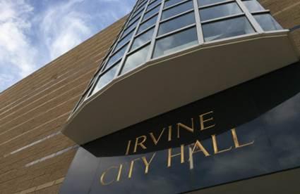
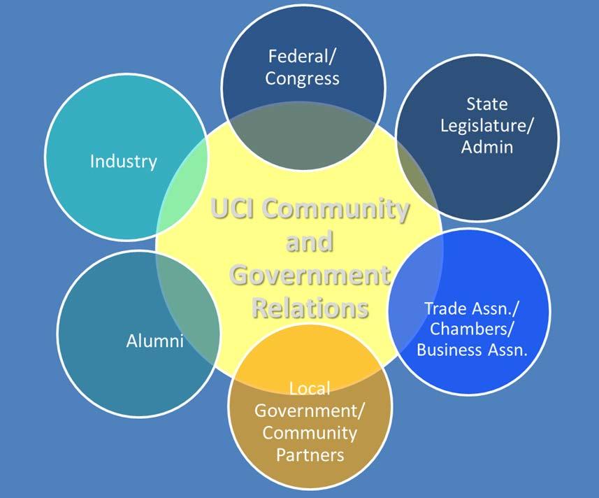
20 ADVOCACY University of California, Irvine, Community and Government Relations


21 ADVOCACY What is Community and Government Relations? advocacy education
22 ADVOCACY Government Relations Objectives Develop and maintain relationships with legislators/elected officials and their staff. Communicate higher education issues to public policy makers and how they impact the system and campus Deliver accurate, timely and relevant information to internal & external stakeholders, advocates and elected officials Develop & mobilize grassroots and grasstop advocates Utilize strategic intelligence to stay In Front of issues Serve as a resource to legislators for campus resources


23 ADVOCACY UC in your District
24 QUESTIONS What questions do you have? Please evaluate and comment on our presentation on the CAIR app.
Advancing Green Chemistry Practices in Business
 Green Chemistry and Commerce Council: 6 th Annual GC3 Innovators Roundtable Advancing Green Chemistry Practices in Business Barbara Peterson, Ph.D. Marty Mulvihill, Ph.D. Program Director Executive Director,
PUBLIC HEALTH ASSOCIATION OF AUSTRALIA Strategic Plan
 PUBLIC HEALTH ASSOCIATION OF AUSTRALIA Strategic Plan March 2017 20 Napier Close Deakin ACT Australia 2600 PO Box 319 Curtin ACT Australia 2605 Table of Contents Introduction... 2 Vision for a healthy
GeoHealth Applications Platform ESRI Health GIS Conference 2013
 GeoHealth Applications Platform ESRI Health GIS Conference 2013 Authors Thomas A. Horan, Ph.D. Professor, CISAT Director April Moreno Health GeoInformatics Ph.D. Student Brian N. Hilton, Ph.D. Clinical
Dana Wright, Director of Academic Program Development
 Academic Program Development 261 University Hall (MC 10) 601 South Morgan Street Chicago, Illinois 60607-7126 February 2, 2016 TO: FROM: Ilene Harris, Chair Senate Committee on Educational Policy Dana
Agenda Item B /20 Strategic Budget Development Phase I Preliminary Recommendations
 Agenda Item B-24 2019/20 Strategic Budget Development Phase I Preliminary Recommendations Board of Education February 13, 2019 2 Outline Preliminary Recommendations and Discussions School Staffing School
Transforming Chemistry Education through the Green Chemistry Commitment. Amy S. Cannon, Ph.D. Executive Director Beyond Benign
 Transforming Chemistry Education through the Green Chemistry Commitment Amy S. Cannon, Ph.D. Executive Director Beyond Benign Headquarters located in Wilmington, MA Co-founded by John Warner and Amy Cannon
About WE RE A PASSIONATE COMPANY FILLED WITH PASSIONATE INDIVIDUALS OUR MISSION OUR VISION OUR TAGLINE OUR NAME
 Media Kit About For more than 65 years, The Arc Northern Chesapeake Region (The Arc NCR) has helped people with intellectual and developmental disabilities to live, work and play in Harford and Cecil Counties.
Chemical Safety as a Core ACS Value: Report on the 2018 Safety Summit
 Chemical Safety as a Core ACS Value: Report on the 2018 Safety Summit Introduction In December 2016, the ACS Board of Directors adopted safety as one of the Society s core values, thus affirming that the
GEOGRAPHIC INFORMATION SYSTEMS
 GEOGRAPHIC INFORMATION SYSTEMS 4-H Round-Up Community Transitions Workshop Daniel Hanselka June 14, 2011 Goals of the Workshop Answer the question: What is GIS? Uses of GIS. Some of the Common Terminology
People Investing in People
 For Office Use Only NATIONAL LEVEL APPLICATION People Investing in People S e n d a c o p y v i a e m a i l t o c l a r a. n u n e z @ p c u s a. o r g a n d f o l l o w u p w i t h a n e m a i l o r p
SOUTH DAKOTA BOARD OF REGENTS. Academic and Student Affairs ******************************************************************************
 SOUTH DAKOTA BOARD OF REGENTS Academic and Student Affairs AGENDA ITEM: 7 C (4) DATE: June 28-30, 2016 ****************************************************************************** SUBJECT: New Minor:
Creating a Staff Development Plan with Esri
 Creating a Staff Development Plan with Esri Michael Green David Schneider Guest Presenter: Shane Feirer, University of California Esri UC 2014 Technical Workshop Agenda What is a Staff Development Plan?
Green Chemistry Commitment
 Info Kit Green Chemistry Commitment What is the Green Chemistry Commitment? The Green Chemistry Commitment (GCC) is a consortium program that unites the green chemistry community around shared goals and
Diffusion of GIS in Public Policy Doctoral Program
 Diffusion of GIS in Public Policy Doctoral Program By Fulbert Namwamba PhD Southern University This presentation demonstrate how GIS was introduced in the Public Policy Doctoral Program at Southern University,
Night Comes to the Cumberlands and It s Awesome: Promoting Night Sky Conservation and Development in the Upper Cumberland
 Night Comes to the Cumberlands and It s Awesome: Promoting Night Sky Conservation and Development in the Upper Cumberland Jean Mercer Assistant Vice Chancellor for Research Office of Sponsored Programs
2010 Census Data Release and Current Geographic Programs. Michaellyn Garcia Geographer Seattle Regional Census Center
 2010 Census Data Release and Current Geographic Programs Michaellyn Garcia Geographer Seattle Regional Census Center 2010 Center of Population Located approximately 2.7 miles northeast of Plato, Missouri
M A K I N G E X C E L L E N C E I N C L U S I V E
 MEI: M A K I N G E X C E L L E N C E I N C L U S I V E R E L I G I O U S D I V E R S I T Y I N T H E H I R I N G P R O C E S S : P R O M I S I N G P R A C T I C E S F O R R E C R U I T I N G D I V E R
NERCHE Self-Assessment Rubric for the Institutionalization of Diversity, Equity, and Inclusion in Higher Education
 NERCHE Self-Assessment Rubric for the Institutionalization of Diversity, Equity, and Inclusion in Higher Education College of Education and Human Development University of Massachusetts Boston 100 Morrissey
Section 2. Indiana Geographic Information Council: Strategic Plan
 Section 2. Indiana Geographic Information Council: Strategic Plan Introduction A geographic information system (GIS) is an automated tool that allows the collection, modification, storage, analysis, and
D2E GIS Coordination Initiative Functional Transformation Kick-Off Meeting
 D2E GIS Coordination Initiative Functional Transformation Kick-Off Meeting GIS Functional Transformation Kick-Off Meeting May 13, 2008 D2E GIS Coordination Initiative Functional Transformation Kick-Off
Strategic Plan
 2013-2015 Strategic Plan April 23, 2014 Introduction The Indiana Geographic Information Council's (IGIC) 2013-2015 Strategic Plan establishes a path of action to meet opportunities and challenges of applying
Map your way to deeper insights
 Map your way to deeper insights Target, forecast and plan by geographic region Highlights Apply your data to pre-installed map templates and customize to meet your needs. Select from included map files
CALIFORNIA STATE POLYTECHNIC UNIVERSITY, POMONA ACADEMIC SENATE ACADEMIC PROGRAMS COMMITTEE REPORT TO THE ACADEMIC SENATE AP
 CALIFORNIA STATE POLYTECHNIC UNIVERSITY, POMONA ACADEMIC SENATE ACADEMIC PROGRAMS COMMITTEE REPORT TO THE ACADEMIC SENATE AP-009-167 BS IN GEOGRAPHY GEOSPATIAL ANALYSIS OPTION Academic Programs Committee
MAKING LOCATION MATTER
 MAKING LOCATION MATTER Action to activate location data for people-centred policy CANBERRA ROUNDTABLE 18 OCTOBER 2017 DISCUSSION NOTES v6.0 Discussion overview and priority actions About the Roundtable
Esri and GIS Education
 Esri and GIS Education Organizations Esri Users 1,200 National Government Agencies 11,500 States & Regional Agencies 30,800 Cities & Local Governments 32,000 Businesses 8,500 Utilities 12,600 NGOs 11,000
DRAFT SYLLABUS. Please use Blackboard to send messages.
 SYLLABUS Course Title: Geographic Information Systems and Spatial Analysis for Public Policy Academic Department/Course Number: PUBP 754 Semester/Year: Fall 2017 Building/Room: FH 307 Days/Time: W 4:30
2018/1 The integration of statistical and geospatial information. The Regional Committee of UN-GGIM: Americas:
 The following are the conclusions and recommendations of the Regional Committee of the United Nations on Global Geospatial Information Management for the Americas, during its Fifth Session, Thursday 8
Nuisance and Call for Service Data Analysis
 Augustana College Augustana Digital Commons 2015-2016: Clinton, Iowa Sustainable Workshops Landscapes Initiative 2016 Nuisance and Call for Service Data Analysis Dr. Jennifer Burnham Augustana College,
1. Omit Human and Physical Geography electives (6 credits) 2. Add GEOG 677:Internet GIS (3 credits) 3. Add 3 credits to GEOG 797: Final Project
 2. Add GEOG 677:Internet GIS (3 credits) 3. Add 3 credits to GEOG 797: Final Project") The Department of Geography and the Office of Professional Studies propose to modify the Master of Professional Studies in Geospatial Information Sciences (GIS) as follows: 1. Omit Human and Physical Geography
The Department of Geography and the Office of Professional Studies propose to modify the Master of Professional Studies in Geospatial Information Sciences (GIS) as follows: 1. Omit Human and Physical Geography
Director, Programs and Academic Assessment
 February 5, 2009 TO: FROM: John Huntington, Chair Senate Committee on Educational Policy Midge Grosch Director, Programs and Academic Assessment I am forwarding for review and action by the Senate Committee
Requirement for the Major in Chemistry with a Concentration in Biochemistry
 Department Chair: R. LaFever Department Office: Science Building II, Room 273 Telephone: (661) 654-3027 email: aparks@csub.edu Website: www.csub.edu/chemistry/ Faculty: K. Cohn, M.L. Dutton, A. Gebauer,
CRP 608 Winter 10 Class presentation February 04, Senior Research Associate Kirwan Institute for the Study of Race and Ethnicity
 CRP 608 Winter 10 Class presentation February 04, 2010 SAMIR GAMBHIR SAMIR GAMBHIR Senior Research Associate Kirwan Institute for the Study of Race and Ethnicity Background Kirwan Institute Our work Using
geographic patterns and processes are captured and represented using computer technologies
 Proposed Certificate in Geographic Information Science Department of Geographical and Sustainability Sciences Submitted: November 9, 2016 Geographic information systems (GIS) capture the complex spatial
BSEE REQUIREMENTS
 College of Engineering The Klipsch School of Electrical and Computer Engineering BSEE REQUIREMENTS 2014-2015 This document presents a summary of the requirements for earning a Bachelor of Science degree
Department Of Geography. MSc Applied GIS.
 Department Of Geography. MSc Applied GIS. This is a really exciting time to be in GIS, with new tools and new software allowing the application of GIS techniques to an ever-increasing range of fields.
PROGRAM EVALUATION REPORT The following information is organized by CACREP-Accredited Program Specialty Areas for
 PROGRAM EVALUATION REPORT 2016-2017 For the 2016-2017 academic year, DePaul Counseling Program faculty conducted a program evaluation by reviewing available data and surveying stakeholders. The following
Licensed Science Officer Benchmark
 POSITION EVALUATION RATIONALE POSITION TITLE MINISTRY AND DIVISION Energy, Mines and Petroleum Resources: Geology Division BRANCH AND SECTION Mineral Resources Branch, Applied Geology Section UNIT OR PROGRAM
PHYSICS MAJOR, B.S. Student Learning Outcomes. Contact Information. Requirements. Department Programs. Physics Major, B.S.
 Physics Major, B.S. PYSICS MAJOR, B.S. Contact Information Department of Physics and Astronomy http://physics.unc.edu Phillips all, CB# 255 (99) 962-2078 Christian Iliadis, Chair Jhon T. Cimmino, Academic
PART A Project summary
 PART A Project summary A.1 Project identification Project title Project acronym Name of the lead partner organisation in English Specific objective Demonstrattion AF DAF Partner 1.1. Improving innovation
Quick Facts College of Polymer Science and Polymer Engineering
 Minor in Polymer Science and Polymer Engineering Program Description: This minor is a 6 course/18 credit program that provides students a broad foundation in polymer science and polymer engineering through
Applies to TU Dublin Tallaght Campus from Jan 1 st 2019
 Applies to TU Dublin Tallaght Campus from Jan 1 st 2019 Severe Weather Management and Communications Plan for Scheduled Classes and Examination Venues 2018/19 Office of the Registrar Document version:
Evaluation Survey - Results
 Evaluation Survey - Results GFMD Civil Society Days Goals, Compacts, Action: Human Mobility That Works for Migrants and Society 4- December 8, Marrakesh, Morocco Made Network #GFMD @Madenetworking http://madenetwork.org/
ArcGIS. for Server. Understanding our World
 ArcGIS for Server Understanding our World ArcGIS for Server Create, Distribute, and Manage GIS Services You can use ArcGIS for Server to create services from your mapping and geographic information system
BACK TO SCHO O L W ITH
 Your web browser (Safari 7) is out of date. For more security, comfort and the best experience on this site: Update your browser Ignore BACK TO SCHO O L W ITH GEO - L ITERACY Essays on Geo-Literacy For
State GIS Officer/GIS Data
 State GIS Officer/GIS Data This Act creates the position of state Geographic Information Systems (GIS) officer. The Act: requires the state GIS officer to adopt or veto the GIS data standards and a statewide
Will this program be printed in the Bulletin? Yes No
 NEW UNDERGRADUATE MINOR / CHANGE UNDERGRADUATE MINOR FORM Please fill out Section I. SECTION I: GENERAL INFORMATION Program: GEO Minor: Geography College: A&S Department: Geography Bulletin PP: 135 CIP
Programme Specification (Undergraduate) Chemistry
 Chemistry") Programme Specification (Undergraduate) BSc Chemistry This document provides a definitive record of the main features of the programme and the learning outcomes that a typical student may reasonably be
Programme Specification (Undergraduate) BSc Chemistry This document provides a definitive record of the main features of the programme and the learning outcomes that a typical student may reasonably be
Introduction to Coastal GIS
 Held on Tues, 1/8/13 through Thurs, 1/10/13 Location: Roger Williams University, Bristol, RI Audience: The intended audiences for this course are federal and state personnel, municipal staff and officials,
Advanced Readings. Environment and Land Use Concentration The following seminars and studios would apply
 Community Development and Housing Concentration URP 720 Urban Housing Policies URP 722 Community Development and Housing URP 724 Urban Revitalization Studio URP 726 Citizen Participation Strategies URP
MASTER OF APPLIED GEOGRAPHY (M.A.GEO.) MAJOR IN GEOGRAPHY RESOURCE AND ENVIRONMENTAL STUDIES
 MAJOR IN GEOGRAPHY RESOURCE AND ENVIRONMENTAL STUDIES") Master of Applied Geography (M.A.Geo.) Major in Geography Resource and Environmental Studies 1 MASTER OF APPLIED GEOGRAPHY (M.A.GEO.) MAJOR IN GEOGRAPHY RESOURCE AND ENVIRONMENTAL STUDIES Major Program
Master of Applied Geography (M.A.Geo.) Major in Geography Resource and Environmental Studies 1 MASTER OF APPLIED GEOGRAPHY (M.A.GEO.) MAJOR IN GEOGRAPHY RESOURCE AND ENVIRONMENTAL STUDIES Major Program
PROGRAM EVALUATION PRELIMINARY REPORT. The following information is organized by program specialty areas for
 PROGRAM EVALUATION PRELIMINARY REPORT For the 2016-2017 academic year, DePaul Counseling Program faculty conducted a program evaluation by reviewing available data and surveying stakeholders. The following
MASTER OF APPLIED GEOGRAPHY (M.A.GEO.) MAJOR IN GEOGRAPHIC INFORMATION SCIENCE
 MAJOR IN GEOGRAPHIC INFORMATION SCIENCE") Master of Applied Geography (M.A.Geo.) Major in Geographic Information Science 1 MASTER OF APPLIED GEOGRAPHY (M.A.GEO.) MAJOR IN GEOGRAPHIC INFORMATION SCIENCE Major Program The Master of Applied Geography
Master of Applied Geography (M.A.Geo.) Major in Geographic Information Science 1 MASTER OF APPLIED GEOGRAPHY (M.A.GEO.) MAJOR IN GEOGRAPHIC INFORMATION SCIENCE Major Program The Master of Applied Geography
School District of Onalaska Annual Report September 2016
 Onalaska High School Eagle Bluff Elementary School District of Onalaska Annual Report September 2016 Northern Hills Elementary Onalaska Middle School Irving Pertzsch Elementary 2 School District of Onalaska
Temporary College Closure Due to Inclement Weather or Other Adverse Conditions.
 OTHER TOPICS Index No. X-1 PROCEDURES MEMORANDUM TO: FROM: SUBJECT: MCC Students and Staff Office of the President Temporary College Closure Due to Inclement Weather or Other Adverse Conditions. DATE:
What can I do with a major in Earth Information Science?
 Lewis-Clark State College offers a Bachelor of Arts or Science Degree in Earth Information Science through the Natural Sciences and Mathematics Division. You can learn more about the Natural Sciences and
Implementing the Sustainable Development Goals: The Role of Geospatial Technology and Innovation
 Fifth High Level Forum on UN Global Geospatial Information Management Implementing the Sustainable Development Goals: The Role of Geospatial Technology and Innovation 28-30 November 2017 Sheraton Maria
Key Elements of the Geographical Information System of Mexico *
 UNITED NATIONS E/CONF.99/IP.1 ECONOMIC AND SOCIAL COUNCIL Ninth United Nations Regional Cartographic Conference for the Americas New York, 10-14 August 2009 Item 7(a) of the provisional agenda Strategy,
GLOBAL GEOPARKS NETWORK
 GLOBAL GEOPARKS NETWORK International Association on Geoparks CELEBRATING EARTH HERITAGE SUSTAINING LOCAL COMMUNITIES REQUEST FOR PROPOSALS Communication & Marketing Strategy FOR UNESCO Global Geoparks
Purpose Study conducted to determine the needs of the health care workforce related to GIS use, incorporation and training.
 GIS and Health Care: Educational Needs Assessment Cindy Gotz, MPH, CHES Janice Frates, Ph.D. Suzanne Wechsler, Ph.D. Departments of Health Care Administration & Geography California State University Long
GRADUATE CERTIFICATE PROGRAM
 GRADUATE CERTIFICATE PROGRAM GEOGRAPHIC INFORMATION SCIENCES Department of Geography University of North Carolina Chapel Hill Conghe Song, Director csong @email.unc.edu 919-843-4764 (voice) 919-962-1537
Strategic Plan for the Geospatial Teaching, Research, and Outreach in CNR. The CNR Geospatial Steering Committee, March 31, 2008
 Strategic Plan for the Geospatial Teaching, Research, and Outreach in CNR The CNR Geospatial Steering Committee, March 31, 2008 Current Mission for the Geospatial Learning Center Established in 1995, the
Ministry of Health and Long-Term Care Geographic Information System (GIS) Strategy An Overview of the Strategy Implementation Plan November 2009
 Strategy An Overview of the Strategy Implementation Plan November 2009") Ministry of Health and Long-Term Care Geographic Information System (GIS) Strategy An Overview of the Strategy Implementation Plan November 2009 John Hill, Health Analytics Branch Health System Information
Ministry of Health and Long-Term Care Geographic Information System (GIS) Strategy An Overview of the Strategy Implementation Plan November 2009 John Hill, Health Analytics Branch Health System Information
CHEMISTRY CONTEXTS 1 SOLUTIONS MANUAL
 page 1 / 5 page 2 / 5 chemistry contexts 1 solutions pdf 7 GCSE Chemistry (8462). For exams 2018 onwards. Version 1.0 Visit aqa.org.uk/8462 for the most up-to-date specification, resources, support and
YOUR CITY INSTITUTIONAL KNOWLEDGE
 2017 PLANNING COMMISSIONERS ACADEMY Free Tools & Resources for Planning Commissioners ERIC A. NELSON CHAIRMAN, CITY OF DANA POINT PLANNING COMMISSION JOEL ROJAS - DEVELOPMENT SERVICES DIRECTOR, SAN JUAN
Overview of the William and Mary GIS Certificate Program. Draft Language as of 4/20/2018
 Overview of the William and Mary GIS Certificate Program Draft Language as of 4/20/2018 The Post-Baccalaureate Certificate in Geospatial Information Systems (Science) provides students with a post-baccalaureate
Building capacity for gender responsive planning and budgeting, the Mozambican experience
 UNIVERSIDADE EDUARDO MONDLANE Building capacity for gender responsive planning and budgeting, the Mozambican experience Generosa Cossa José Director, Centre for Coordination of Gender Issues Eduardo Mondlane
ESSENTIAL CONCEPTS AND SKILL SETS OF THE IOWA CORE CURRICULUM
 ESSENTIAL CONCEPTS AND SKILL SETS OF THE IOWA CORE CURRICULUM SOCIAL STUDIES PROVIDED BY THE IOWA DEPARTMENT OF EDUCATION INTRODUCTION Social studies is the integrated study of the social sciences and
Priority Topics in Seafloor Engineering Research at the Naval Facilities Engineering Service Center Port Hueneme, California
 Priority Topics in Seafloor Engineering Research at the Naval Facilities Engineering Service Center Port Hueneme, California Mark R. Tufenkjian Department of Civil Engineering, California State University,
Inclement Weather FAQ s
 Inclement Weather FAQ s Where can I find the OSU Stillwater and OSU Tulsa guidance on Inclement Weather? https://hr.okstate.edu/weather Who determines when an Inclement Weather closing is declared for
Programme Specification (Undergraduate) MSci Chemistry
 MSci Chemistry") Programme Specification (Undergraduate) MSci Chemistry This document provides a definitive record of the main features of the programme and the learning outcomes that a typical student may reasonably be
Programme Specification (Undergraduate) MSci Chemistry This document provides a definitive record of the main features of the programme and the learning outcomes that a typical student may reasonably be
Highlights from the 2014 AMS Washington Forum (AWF)
") Highlights from the 2014 AMS Washington Forum (AWF) Shawn Miller Chief Architect, JPSS CGS, Raytheon Company Chair, AMS Board on Economic Development (BEED) shawn_w_miller@raytheon.com Thomas Fahy Principal,
Highlights from the 2014 AMS Washington Forum (AWF) Shawn Miller Chief Architect, JPSS CGS, Raytheon Company Chair, AMS Board on Economic Development (BEED) shawn_w_miller@raytheon.com Thomas Fahy Principal,
FINAL REPORT EVALUATION REVIEW OF TVA'S LOAD FORECAST RISK
 Memorandum from the Office of the Inspector General Robert Irvin, WT 9C-K FINAL REPORT EVALUATION 2012-14507 REVIEW OF TVA'S LOAD FORECAST RISK As part of a series of reviews to evaluate the Tennessee
HOW TO IMPROVE LINKS BETWEEN SCHOOL GEOGRAPHY DEPARTMENTS AND LOCAL UNIVERSITY GEOGRAPHY and EDUCATION DEPARTMENTS
 CGEOG (TEACHER) ONLINE CPD MODULE HOW TO IMPROVE LINKS BETWEEN SCHOOL GEOGRAPHY DEPARTMENTS AND LOCAL UNIVERSITY GEOGRAPHY and EDUCATION DEPARTMENTS By Garry Atterton Chartered Geographer (Teacher) The
Strategic Planning for the Arts
 Strategic Planning for the Arts Summary of Online Surveys Buena Vista Conference Center December 16, 2009 Focus Groups - Overview Six focus groups conducted in September and early October Six to eight
An online data and consulting resource of THE UNIVERSITY OF TOLEDO THE JACK FORD URBAN AFFAIRS CENTER
 An online data and consulting resource of THE JACK FORD URBAN AFFAIRS CENTER THE CENTER FOR GEOGRAPHIC INFORMATION SCIENCE AND APPLIED GEOGRAPHICS DEPARTMENT OF GEOGRAPHY AND PLANNING THE UNIVERSITY OF
Are You Maximizing The Value Of All Your Data?
 Are You Maximizing The Value Of All Your Data? Using The SAS Bridge for ESRI With ArcGIS Business Analyst In A Retail Market Analysis SAS and ESRI: Bringing GIS Mapping and SAS Data Together Presented
Oregon Department of Transportation. Geographic Information Systems. Implementation Plan. Adopted November, 2000 By the GIS Steering Committee
 Oregon Department of Transportation Geographic Information Systems Implementation Plan Adopted November, 2000 By the GIS Steering Committee Introduction The Oregon Department of Transportation (ODOT) GIS
Programme title: MChem Chemistry (Mathematical and Computational Chemistry)
") Faculty of Life Sciences Programme Specification Programme title: MChem Chemistry (Mathematical and Computational Chemistry) Academic Year: 2018/19 Degree Awarding Body: Final and interim award(s): University
Faculty of Life Sciences Programme Specification Programme title: MChem Chemistry (Mathematical and Computational Chemistry) Academic Year: 2018/19 Degree Awarding Body: Final and interim award(s): University
GIS and Community Health. GIS and Community Health. Institutional Context and Interests in GIS Development. GIS and Community Health
 GIS and Community Health GIS and Community Health Some critiques of GIS emphasize the potentially harmful social consequences of the diffusion of GIS technology, including reinforcing the power of state
David Lanter PhD GISP. Information Security Risks and Controls of Public Geospatial Datasets July 17, 2014
 David Lanter PhD GISP Information Security Risks and Controls of Public Geospatial Datasets July 17, 2014 This Presentation CDM Smith applies GIS and develops custom applications producing, deploying and
Enrollment of Students with Disabilities
 Enrollment of Students with Disabilities State legislation, which requires the Board of Higher Education to monitor the participation of specific groups of individuals in public colleges and universities,
Basic Training Battlemind to Home Symposium. Sept
 Basic Training Battlemind to Home Symposium Sept 2017 1 What is Measuring Communities? A social indicators project which allows users to obtain military-specific information about communities strengths
Integrating Official Statistics and Geospatial Information NBS Experience
 Integrating Official Statistics and Geospatial Information NBS Experience Presented by Eng. Reda AL Sabbagh Director of IT Dept. Prepared by Eng. Adham Makky GIS Specialist Topics to be covered: Background
Advising and Advice at Cal: What do Undergraduates Tell Us?
 Advising and Advice at Cal: What do Undergraduates Tell Us? G R E G G T H O M S O N, C Y N D Y S N Y D E R, & S E R E E TA A L E X A N D E R A S S I S T E D B Y A LY X F L O U R N O Y A N D P E D R O S
The Basics of Weighted Student (Need-Based) Education Funding:
 Education Funding:") The Basics of Weighted Student (Need-Based) Education Funding: An Overview Presenter: Mary Fertakis, M.Ed. LEV Advocates Training Sat., Feb. 11, 2017 The Current System is Not Closing Achievement Gaps
The Basics of Weighted Student (Need-Based) Education Funding: An Overview Presenter: Mary Fertakis, M.Ed. LEV Advocates Training Sat., Feb. 11, 2017 The Current System is Not Closing Achievement Gaps
Maximizing the effectiveness and socio-economic benefits of weather products and services the Hong Kong Experience
 Maximizing the effectiveness and socio-economic benefits of weather products and services the Hong Kong Experience Queenie C.C. Lam Scientific Officer Hong Kong Observatory Hong Kong, China Meeting of
Comprehensive Curriculum for 8 th Grade Social Studies. Unit GLE s Guiding Questions Can students do the following (?) Allotted Time Chapters 1
 Allotted Time Chapters 1") Unit GLE s Guiding Questions Can students do the following (?) Allotted Time Chapters 1 Physical and Cultural Geography of Louisiana 1. Time Zones 2. Place Location 3. Map Construction 4. Chart/Graph Construction
Unit GLE s Guiding Questions Can students do the following (?) Allotted Time Chapters 1 Physical and Cultural Geography of Louisiana 1. Time Zones 2. Place Location 3. Map Construction 4. Chart/Graph Construction
Students seeking a teaching credential may elect chemistry as their major within the teaching credential program in science.
 skip navigation Sonoma State University Search SSU Catalog ACADEMIC PROGRAMS CHEMISTRY Word from the President SSU Snapshots Year in the Life, Videos Department Office Darwin Hall 126 (707) 664-2334 www.sonoma.e
Down East RPO. Strategic Prioritization Office of Transportation Local Input Point Assignment Methodology. Introduction
 Down East RPO Introduction Strategic Prioritization Office of Transportation Local Input Point Assignment Methodology The Down East Rural Planning Organization (DERPO) is required by state law to develop
GTECH 380/722 Analytical and Computer Cartography Hunter College, CUNY Department of Geography
 GTECH 380/722 Analytical and Computer Cartography Hunter College, CUNY Department of Geography Fall 2014 Mondays 5:35PM to 9:15PM Instructor: Doug Williamson, PhD Email: Douglas.Williamson@hunter.cuny.edu
COMMISSION ON ACCREDITATION 2011 ANNUAL REPORT ONLINE
 COMMISSION ON ACCREDITATION 2011 ANNUAL REPORT ONLINE SUMMARY DATA: POSTDOCTORAL PROGRAMS ^Clicking a table title will automatically direct you to that table in this document *Programs that combine two
WELCOME & INTRODUCTIONS
 GIS Monroe Geographic Information System January 31, 2018 WELCOME & INTRODUCTIONS Chip Thomas, Ritter GIS Sarah Schrader, Acct. Mgr., ESRI Chris Beyett, Solutions Engineer, ESRI Colleen Hinzmann, IT Director,
GREAT IDEAS IN PHYSICS
 PHYSICS 103-01 TR 0800 0915 DL312 http://people.uncw.edu/morrisonj/courses/phy103syllabus.htm GREAT IDEAS IN PHYSICS SYLLABUS INSTRUCTOR: JOHN M. MORRISON OFFICE: DL-201 and MYRTLE GROVE 2331 EMAIL: morrisonj@uncw.edu
Tornado Drill Exercise Plan (EXPLAN)
") Tornado Drill Exercise Plan (EXPLAN) As part of the National Weather Service s (NWS) Severe Weather Preparedness Week in Indiana Purdue University March 19, 2019 As of Feb 19, 2019 TABLE OF CONTENTS Introduction...
Tornado Drill Exercise Plan (EXPLAN) As part of the National Weather Service s (NWS) Severe Weather Preparedness Week in Indiana Purdue University March 19, 2019 As of Feb 19, 2019 TABLE OF CONTENTS Introduction...
Compact guides GISCO. Geographic information system of the Commission
 Compact guides GISCO Geographic information system of the Commission What is GISCO? GISCO, the Geographic Information System of the COmmission, is a permanent service of Eurostat that fulfils the requirements
Policy and Procedures For Issuing Timely Warnings
 The Pennsylvania State University Policy and Procedures For Issuing Timely Warnings I. Purpose The purpose of this Policy is to establish a process by which The Pennsylvania State University (hereinafter
Department of Chemistry
 Department of Chemistry Learning Assessment Plan: 2006-07 The Chemistry Department s Learning Outcomes Assessment Plan is included as Appendix 2. Based on how our concentrators have done in post-graduate
Request for the use of the Doppler on Wheels (DOW) NSF Facility for Education DOW Observations of Lake-Effects
 NSF Facility for Education DOW Observations of Lake-Effects") Request for the use of the Doppler on Wheels (DOW) NSF Facility for Education DOW Observations of Lake-Effects Scott M. Steiger Department of Earth Sciences The State University of New York at Oswego Oswego,
Request for the use of the Doppler on Wheels (DOW) NSF Facility for Education DOW Observations of Lake-Effects Scott M. Steiger Department of Earth Sciences The State University of New York at Oswego Oswego,
GIS Monroe Geographic Information System March 14, 2018
 GIS Monroe Geographic Information System March 14, 2018 Goals Maintain Enterprise/County-wide geo-database Increase spatial accuracy of data Build and acquire more data layers Increase use of GIS; as another
Introduction to the Geographical Sciences Committee. AAG Annual Meeting April 2017
 Introduction to the Geographical Sciences Committee AAG Annual Meeting April 2017 The National Academies of Sciences, Engineering, and Medicine Inform decision making and public policy Provide independent