an approach to understanding repository and service interactions
|
|
|
- Derek Moody
- 5 years ago
- Views:
Transcription
1 The repository ecology: an approach to understanding repository and service interactions R. John Robertson Repositories Research Officer JISC-CETISCETIS OAI5 19th April
2 Outline The implementation challenge A repository ecology? A scholarly research ecology Ecology concepts Data and elearning ecologies Using this approach Future developments OAI5 19th April
3 The implementation challenge The repositories i domain is well served by technical specifications and architectural models Implementers of repositories and dependent services are however, still faced with a challenge to plan and manage their service in relation to the rest of the information environment In particular they face challenges when trying to: Articulate needs Identify opportunities Express complexity Manage development OAI5 19th April
4 The implementation challenge (2) Boundaries Primarily interested in the academic sector A focus on the institutional and subject repository domain An interest tin interactions ti (technical and non-technical) l)between services and between repositories and services Characteristics A semi-structured information space sitting between the highlyordered library world and the unstructured web Between AACR2 and agreeing a del.icio.us tag Often using OAI-PMH and Dublin Core Interacting with both library catalogues and web 2.0 tools Frequently providing a service based Open Source software such as, eprints, DSpace, Fedora Repository as an abbreviation for a particular set of functions implemented and used in a particular cultural setting OAI5 19th April
5 A repository ecology? Brewbrooks (2007) OAI5 19th April
6 A repository ecology? (2) The idea of an information ecology A way of thinking about the relationships between information systems and services Information systems are like ecologies: Multiple interacting things Dependent on each other Connections are not always obvious to participants A repository ecology as a type of information ecology OAI5 19th April
7 The eexample peof ascholarly oa research eseac ecology The first stage of the research process the initial iti literature review/search process User carries out a number of different search tasks Looks in Google Finds eprints in a relevant subject repository Checks recent theses Is notified by RSS of recent deposits in subject domain at local institutional repository Checks aggregated search service for other eprints Finds additional papers because harvester enhances query using subject terminology mapping Uses library interface to locate publisher s version of an article OAI5 19th April
8 A scholarly research ecology (2) ArXiv Strathprints RGU QUEprints Loughborough Netvibes OAISTER HILT ELIS Google EThOS Metalib Emerald OAI5 19th April
9 Ecology concepts We believe that the ecology metaphor provides a distinctive, powerful set of organizing properties around which to have conversations. The ecological metaphor suggests several key properties of many environments in which technology is used. An information ecology is a complex system of parts and relationships. It exhibits diversity and experiences continual evolution. Different parts of an ecology coevolve, changing together according to the relationships in the system. Several keystone species necessary to the survival of the ecology are present. Information ecologies have a sense of locality. Nardi and O Day ODay (1999) First Monday 4 (5) html OAI5 19th April
10 Ecology concepts (2) System Diversity changes can affect whole ecology local changes not in line with dynamic of the ecology may fail different kinds of species can work together species overlap and duplicate to a degree Monoculture - a fake, brittle ecology - gives sensational results for a short ttime, then completely ltl fil fails. OAI5 19th April
11 Ecology concepts (3) Coevolution the ecology is constantly changing new things develop existing iti things continue to develop existing things are used differently Keystone species Locality critical species needed for ecology to survive; these are often middleware - infrastructure and people who make and assist connections name : what something is used for in a particular location habitation : ti how this thing sits within a network of relationships with other things OAI5 19th April
12 An scientific c overlay journal ecology: ogy basic elements OAI5 19th April
13 An scientific c overlay journal ecology: ogy adding data capture OAI5 19th April
14 An scientific c overlay journal ecology: ogy bringing in other repositories OAI5 19th April
15 An scientific c overlay journal ecology: ogy the bigger picture : White Rose repository Sherpa Romeo BADC IEMSR RMetS IESR/ OpenDOAR/ ROAR Preserv OJIMS DCC OAI5 19th April


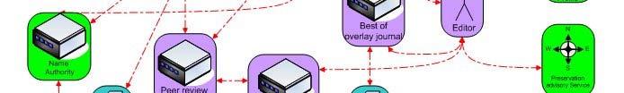
16 An scientific c overlay journal ecology: ogy analysis Keystone Keystone Species Diversity Species Keystone Species Diversity Keystone Species Diversity Keystone Species Diversity OAI5 19th April
17 An elearning ecology Bloglines Moodle del.icio.us Blogger Slideshare Youtube OAI5 19th April
18 An elearning ecology Diversity Keystone Species Keystone Species Keystone Species Diversity Diversity Keystone Species OAI5 19th April
19 Using this approach: what benefit does it offer? For an end user Services that have thought about their place in a wider network may offer the user a richer, multifaceted, and more personalised service For a repository or service administrator The ecology approach offers the opportunity to looking for efficiencies and, as indicated above, to offer better services For developers and funding agencies The ecology approach offers another approach to examining how services and repositories relate and interoperate and what aspects of the environment present opportunities or are under threat OAI5 19th April
20 Using this approach: thinking ecologically Key questions for thinking about interactions between repositories and services What sort of thing (repository or service) is this? What does it relate to (other repositories or services)? What does it depend on? How adaptable is it? What helps it to thrive? OAI5 19th April
21 An scientific c overlay journal ecology: ogy the bigger picture - revisited OAI5 19th April
22 Using this approach: the scientific overlay journal What sort of thing (repository or service) is this? Overlay journal based on subject and data repositories What does it relate to (other repositories or services)? illustrated connections (and more) What does it depend on? Success of DR and SR advocacy as well as technical deposit mechanisms Publishers licensing agreements and being able to discover this information How adaptable is it? Presenting different views of data Offering lots of service discovery points What helps it to thrive? Google visibility / fit with RAE (or equivalent exercise)/ other measurable prestige OAI5 19th April
23 A repository ecology It is not the only way to approach any of these issues but a repository ecology allows: A way for repositories and services to articulate their place in the information environment An approach for implementers to identify areas of opportunity within their communities A mechanism to present the complexity of real settings (with different views on them) A support for planning and decision making that can identify missing links and crucial elements OAI5 19th April
24 Future developments, e e Acknowledgements, Questions Further developments In the coming months, we will: Explore useful extensions of the metaphor Produce a report for JISC Hold a workshop on developing and applying the approach Acknowledgements Questions OAI5 19th April
25 Further information Information Ecology Bonnie A. Nardi, and Vicki L O Day, ODay, First Monday Vol 4 No 5 May 3, Information ecologies: using technology with heart. Chapter Four: Information ecologies. Thomas H. Davenport, Information ecology, OUP, 1997 Repository Ecology and related work R. Heery and A. Powell, Digital Repositories Roadmap: looking forward Rachel Heery and Sheila Anderson, Digital Repositories Review, UKOLN and AHDS, 2005 (Final version) R. J. Robertson and J. Barton, "Optimising Metadata Workflows in a Distributed Information Environment", Digital Repositories: Interoperability and Common Services, The Foundation for Research and Technology, May 2005, Hellas (FORTH), Heraklion, Crete, 2005, rep workshop/robertsonbarton.pdf Robertson, R.J. et al. EThOS, the new UK e-theses service, national and institutional repository interaction. JISC Conference, March J. Barton and R.J. Robertson, Developing a metadata lifecycle model Workshop at CoLIS 5, June 2005, ac orkshop htm Kerry Blinko and Neil McLean, 'A 'Cosmic' View of the Repositories Space (Wheel of Fortune)', 2004, OAI5 19th April
An ecologically influenced approach
 An ecologically influenced approach Towards a European ecology Workshop at ECDL 2007, Budapest R. John Robertson, Repositories Research Officer JISCCETIS 21st Sept 2007, robert.robertson@strath.ac.uk R.
Strathprints Institutional Repository
 Strathprints Institutional Repository Robertson, R.J. (2007) An ecologically influenced approach. In: Towards an European repository ecology: conceptualising interactions between networks of repositories
EXPECTATIONS OF TURKISH ENVIRONMENTAL SECTOR FROM INSPIRE
 EXPECTATIONS OF TURKISH ENVIRONMENTAL SECTOR FROM INSPIRE June, 2010 Ahmet ÇİVİ Tuncay DEMİR INSPIRE in the Eyes of MoEF Handling of Geodata by MoEF Benefits Expected TEIEN First Steps for INSPIRE Final
Portals: Standards in Action
 Portals: Standards in Action David Danko ISO TC 211 Metadata Project Leader GIS Standards Consultant-ESRI. Metadata Portals Portal gateway, place of entry Producers Advertise, expose products Share information
The Current Status of EarthCube with an EarthScope Perspective. Tim Ahern IRIS Director of Data Services
 The Current Status of EarthCube with an EarthScope Perspective Tim Ahern IRIS Director of Data Services Key Aspects of EarthCube EarthCube Empowers cross-domain data discovery, interoperability, Current
Exploring Digital Welfare data using GeoTools and Grids
 Exploring Digital Welfare data using GeoTools and Grids Hodkinson, S.N., Turner, A.G.D. School of Geography, University of Leeds June 20, 2014 Summary As part of the Digital Welfare project [1] a Java
Technical Specifications. Form of the standard
 Used by popular acceptance Voluntary Implementation Mandatory Legally enforced Technical Specifications Conventions Guidelines Form of the standard Restrictive Information System Structures Contents Values
GIS and Information Management. Steve Cooper Chief Communications Officer PPDM Association
 GIS and Information Management Steve Cooper Chief Communications Officer PPDM Association GIS and Information Management The traditional role of GIS in the oil and gas industry GIS as part of the Information
Status of implementation of the INSPIRE Directive 2016 Country Fiches. COUNTRY FICHE Malta
 Status of implementation of the INSPIRE Directive 2016 Country Fiches COUNTRY FICHE Malta Introduction... 1 1. State of Play... 2 1.1 Coordination... 2 1.2 Functioning and coordination of the infrastructure...
Reducing Consumer Uncertainty
 Spatial Analytics Reducing Consumer Uncertainty Eliciting User and Producer Views on Geospatial Data Quality Introduction Cooperative Research Centre for Spatial Information (CRCSI) in Australia Communicate
Research Data Management Infrastructure at Oxford. Neil Jefferies R&D Project Manager, Bodleain Libraries
 Research Data Management Infrastructure at Oxford Neil Jefferies R&D Project Manager, Bodleain Libraries Neil.Jefferies@bodleian.ox.ac.uk A bit of background... RDM - UK National Context Several well-established
Ready for INSPIRE.... connecting worlds. European SDI Service Center
 Ready for INSPIRE Consultancy SOFTWARE T r a i n i n g Solutions... connecting worlds European SDI Service Center Increasing Added Value with INSPIRE and SDI Components INSPIRE In 2007, the European Commission
CHAPTER 22 GEOGRAPHIC INFORMATION SYSTEMS
 CHAPTER 22 GEOGRAPHIC INFORMATION SYSTEMS PURPOSE: This chapter establishes the administration and use of to improve the quality and accessibility of Department s spatial information and support graphical
Journal of e-media Studies Volume 3, Issue 1, 2013 Dartmouth College
 Journal of e-media Studies Volume 3, Issue 1, 2013 Dartmouth College Review of Old Maps Online Alyssa McLeod Labeled Google for old maps by its creators, the Jisc-funded Old Maps Online is an interface
SDI-Challenges European perspective
 THE HIGH LEVEL FORUM ON GLOBAL GEOSPATIAL INFORMATION MANAGEMENT Seoul, Republic of Korea, 24-26 October 2011 Session 1: Challenges in geospatial policy formation and institutional arrangements SDI-Challenges
The Canadian Ceoscience Knowledge Network. - A Collaborative Effort for Unified Access to Ceoscience Data
 The Canadian Ceoscience Knowledge Network - A Collaborative Effort for Unified Access to Ceoscience Data The Canadian Geoscience Knowledge Network A Collaborative Effort for Unified Access to Geoscience
RESEARCG ON THE MDA-BASED GIS INTEROPERABILITY Qi,LI *, Lingling,GUO *, Yuqi,BAI **
 RESEARCG ON THE MDA-BASED GIS INTEROPERABILITY Qi,LI *, Lingling,GUO *, Yuqi,BAI ** * Digital Earth Studio, Peking University, Beijing, 100871 liqi@pku.edu.cn, guolingling@cybergis.org.cn ** Network Department,
Aboriginal communities strengthen governance with location-based tools in the 21st century
 Aboriginal communities strengthen governance with location-based tools in the 21st century Today, Aboriginal communities are taking advantage of the geomatics technologies that underpin popular online
The purpose of this report is to recommend a Geographic Information System (GIS) Strategy for the Town of Richmond Hill.
 Strategy for the Town of Richmond Hill.") Staff Report for Committee of the Whole Meeting Department: Division: Subject: Office of the Chief Administrative Officer Strategic Initiatives SRCAO.18.12 GIS Strategy Purpose: The purpose of this report
Staff Report for Committee of the Whole Meeting Department: Division: Subject: Office of the Chief Administrative Officer Strategic Initiatives SRCAO.18.12 GIS Strategy Purpose: The purpose of this report
Implementing the Smart Growth Priority in an Open and Interoperable System for Geographic Data: Sardinia SITR- IDT
 REGION OF SARDINIA (ITALY) LOCAL AUTHORITY FOR MUNICIPALITIES, FINANCES AND URBAN PLANNING DEPT. FOR THE REGIONAL SPATIAL DATA INFRASTRUCTURE Implementing the Smart Growth Priority in an Open and Interoperable
Basic Dublin Core Semantics
 Basic Dublin Core Semantics DC 2006 Tutorial 1, 3 October 2006 Marty Kurth Head of Metadata Services Cornell University Library Getting started Let s introduce ourselves Let s discuss our expectations
Finding Common Ground Through GIS
 Finding Common Ground Through GIS Matthew Stone, MPH Special Unit for Technical Assistance Chronic Disease and Injury Control California Department of Public Health ESRI Health GIS Conference Scottsdale,
A Map Through Time Virtual Historic Cities
 A Map Through Time Virtual Historic Cities NEW WAYS OF EXPLORING DIGITAL COLLECTIONS FLORIDA INTERNATIONAL UNIVERSITY JAMIE ROGERS Coral Gables Virtual Historic City & Unearthing St. Augustine s Colonial
GIS Visualization: A Library s Pursuit Towards Creative and Innovative Research
 GIS Visualization: A Library s Pursuit Towards Creative and Innovative Research Justin B. Sorensen J. Willard Marriott Library University of Utah justin.sorensen@utah.edu Abstract As emerging technologies
CLICK HERE TO KNOW MORE
 CLICK HERE TO KNOW MORE GeoSpace for Singapore s Whole-of-Government Data Sharing Asia GeoSpatial Forum 17 19 Oct 2011 Lee Kim Haw Singapore Land Authority Introducing Singapore Land Authority Limited
Harmonizing spatial databases and services at local and regional level
 Harmonizing spatial databases and services at local and regional level A. Ionita 1, M. Caian 2, V. Vassilev 3, V. Craciunescu 2, I. Nedelcu 4 1 Research Institute for Artificial Intelligence, Bucuresti,
Management of Geological Information for Mining Sector Development and Investment Attraction Examples from Uganda and Tanzania
 Mineral Wealth Conference 2016 Kampala / Uganda Management of Geological Information for Mining Sector Development and Investment Attraction Examples from Uganda and Tanzania Andreas Barth 1, Andreas Knobloch
Concept Formulation of Geospatial Infrastructure. Hidenori FUJIMURA*
 Concept Formulation of Geospatial Infrastructure 1 Concept Formulation of Geospatial Infrastructure Hidenori FUJIMURA* (Published online: 28 December 2016) Abstract Technical trends in the field of surveying
Spatial data interoperability and INSPIRE compliance the platform approach BAGIS
 Spatial data interoperability and INSPIRE compliance the platform approach BAGIS BAGIS Voluntary, independent, public, non-profit organization; Organization with main mission to promote the growth of the
Building a national spatial data infrastructure. Thorben Hansen, Head of Division Danish Agency for Data Supply and Efficiency
 Building a national spatial data infrastructure Thorben Hansen, Head of Division Danish Agency for Data Supply and Efficiency About Spatial Data Infrastructure Spatial data come from many sources and is
The. Michael P. Gerlek, OSGeo & LizardTech. GeoWeb 2006 Vancouver, BC 26 July 2006
 The Open Source Geospatial Foundation Michael P. Gerlek, OSGeo & LizardTech Vancouver, BC 26 July 2006 1 Who Speaks for Open Source in the GIS Community? Some motivations: promote the use of open source
Ontology Summit Framing the Conversation: Ontologies within Semantic Interoperability Ecosystems
 Ontology Summit 2016 Framing the Conversation: Ontologies within Semantic Interoperability Ecosystems GeoSciences Track: Semantic Interoperability in the GeoSciences Gary Berg-Cross and Ken Baclawski Co-Champions
Creating A-16 Compliant National Data Theme for Cultural Resources
 Creating A-16 Compliant National Data Theme for Cultural Resources Cultural Resource GIS Facility National Park Service John J. Knoerl Deidre McCarthy Paper 169 Abstract OMB Circular A-16 defines a set
Measuring the Economic Impact of Tourism on Cities. Professor Bruce Prideaux James Cook University Australia
 Measuring the Economic Impact of Tourism on Cities Professor Bruce Prideaux James Cook University Australia Outline of Presentation Aim and scope Methodology Current range of indicators The way forward
Ministry of ICT of I.R.IRAN
 The ECO 8/6 mill km 2 10 Slamic countries ~330 mill people Oil, Gas, Industries,Tourism 2 Issue transformation in last decade Problem solving needs more integrated approach More interaction &complexity
GIS Building Communities beyond National Borders (Building Successful Spatial Data Infrastructures) Nick Land, ESRI Europe
 Nick Land, ESRI Europe") GIS Building Communities beyond National Borders (Building Successful Spatial Data Infrastructures) Nick Land, ESRI Europe UK worst flooding in the last 60 years 350,000 households without drinking water
GIS Building Communities beyond National Borders (Building Successful Spatial Data Infrastructures) Nick Land, ESRI Europe UK worst flooding in the last 60 years 350,000 households without drinking water
OPEN ACCESS GEOLOGY: USING THE INSTITUTIONAL REPOSITORY TO HOST STATE GEOLOGICAL SURVEY PUBLICATIONS
 OPEN ACCESS GEOLOGY: USING THE INSTITUTIONAL REPOSITORY TO HOST STATE GEOLOGICAL SURVEY PUBLICATIONS Lisa Johnston and Harvey Thorleifson Science and Engineering Library, University of Minnesota, 108 Walter
Selection criteria for the preservation of e-prints
 !74 0.94.:2039 Selection criteria for the preservation of e-prints Circulation: PUBLIC Gareth Knight Arts & Humanities Data Service Summary This paper provides guidance on methods of identifying potentials
E-Government and SDI in Bavaria, Germany
 135 E-Government and SDI in Bavaria, Germany Wolfgang STOESSEL, Germany Key words: GDI-BY, Bavaria, Spatial Data Infrastructure SUMMARY Spatial Data Infrastructure (SDI) is an important part of the e-government
Spatially Enabled Society
 International Seminar on Land Administration Trends and Issues in Asia and the Pacific Region Spatially Enabled Society Abbas Rajabifard Vice Chair PCGIAP-WG3 Vice-President (President Elect), GSDI Association
Chemists are from Mars, Biologists from Venus. Originally published 7th November 2006
 Chemists are from Mars, Biologists from Venus Originally published 7th November 2006 Chemists are from Mars, Biologists from Venus Andrew Lemon and Ted Hawkins, The Edge Software Consultancy Ltd Abstract
Science Analysis Tools Design
 Science Analysis Tools Design Robert Schaefer Software Lead, GSSC July, 2003 GLAST Science Support Center LAT Ground Software Workshop Design Talk Outline Definition of SAE and system requirements Use
Open spatial data infrastructure
 Open spatial data infrastructure a backbone for digital government Thorben Hansen Geomatikkdagene 2018 Stavanger 13.-15. mars Spatial Data Infrastructure definition the technology, policies, standards,
TOWARDS THE DEVELOPMENT OF A MONITORING SYSTEM FOR PLANNING POLICY Residential Land Uses Case study of Brisbane, Melbourne, Chicago and London
 TOWARDS THE DEVELOPMENT OF A MONITORING SYSTEM FOR PLANNING POLICY Residential Land Uses Case study of Brisbane, Melbourne, Chicago and London Presented to CUPUM 12 July 2017 by Claire Daniel Urban Planning/Data
Richard R. Heim Jr. Michael J. Brewer
 Linking GDIS Data Sets Using the NIDIS Drought Portal Richard R. Heim Jr. Michael J. Brewer NOAA/NESDIS/ Asheville, North Carolina International Global Drought Information System Workshop: Next Steps Caltech
What s the problem? A Modern Odyssey in Search of Relevance. The search for relevance. Some current drivers for new services. Some Major Applications
 A Modern Odyssey in Search of Relevance FIG Working Week, Athens, 24 May 2004 Paul Kelly ANZLIC Executive Director The search for relevance 1. New expectations for spatial services 2. Are we ready to meet
Developing a Spatial Data Infrastructure for Cultural Heritage
 Developing a Spatial Data Infrastructure for Cultural Heritage Peter M c Keague (RCAHMS) Anthony Corns and Robert Shaw (Discovery Programme) Developing a Spatial Data Infrastructure for Cultural Heritage
NOKIS - Information Infrastructure for the North and Baltic Sea
 NOKIS - Information Infrastructure for the North and Baltic Sea Carsten Heidmann 1 and Jörn Kohlus 2 Abstract 1. General The initial motivation for the project NOKIS (German title: Nord- und Ostsee-Küsteninformationssystem)
Geo-portal as a Data Sharing Platform for Early Warning System in the Pacific
 EXPERT SEMINAR ON INTEGRATED STATISTICS FOR THE SDGS Geo-portal as a Data Sharing Platform for Early Warning System in the Pacific 11-13 DECEMBER 2017 BANGKOK, THAILAND Youjin Choe Natural disasters and
FROM MOLECULAR FORMULAS TO MARKUSH STRUCTURES
 FROM MOLECULAR FORMULAS TO MARKUSH STRUCTURES DIFFERENT LEVELS OF KNOWLEDGE REPRESENTATION IN CHEMISTRY Michael Braden, PhD ACS / San Diego/ 2016 Overview ChemAxon Who are we? Examples/use cases: Create
GSDI: Towards a Spatially Enabled Society
 GSDI: Towards a Spatially Enabled Society Dr. David J. Coleman, President Global Spatial Data Infrastructure Association UN Regional Cartographic Conference for the Americas, United Nations, New York,
From the Venice Lagoon Atlas towards a collaborative federated system
 From the Venice Lagoon Atlas towards a collaborative federated system City of Venice Alessandro Mulazzani CORILA Consortium for Coordination of Research Activities Concerning the Venice Lagoon System ISMAR-CNR
Global Geospatial Information Management Country Report Finland. Submitted by Director General Jarmo Ratia, National Land Survey
 Global Geospatial Information Management Country Report Finland Submitted by Director General Jarmo Ratia, National Land Survey Global Geospatial Information Management Country Report Finland Background
GLP Workshop on. The design of integrative models of natural and social systems in land change science
 The Global land Project Nodal Office on Integration and Modelling, Aberdeen, UK GLP Workshop on The design of integrative models of natural and social systems in land change science Introduction Post Workshop
ISO Series Standards in a Model Driven Architecture for Landmanagement. Jürgen Ebbinghaus, AED-SICAD
 ISO 19100 Series Standards in a Model Driven Architecture for Landmanagement Jürgen Ebbinghaus, AED-SICAD 29.10.2003 The Company 100% SIEMENS PTD SIEMENS Business Services Shareholder & Strategic Business
NOAA Surface Weather Program
 NOAA Surface Weather Program Maintenance Decision Support System Stakeholder Meeting #9 Jim O Sullivan NOAA Surface Weather Program Manager NWS Office of Climate, Water, and Weather Services September
SPECCHIO for Australia: taking spectroscopy data from the sensor to discovery for the Australian remote sensing community
 University of Wollongong Research Online Faculty of Science, Medicine and Health - Papers Faculty of Science, Medicine and Health 2013 SPECCHIO for Australia: taking spectroscopy data from the sensor to
Digital Weft. InterPARES as common thread in Vancouver s Digital Preservation Programme. CITRA Oslo Sept 15, 2010
 Digital Weft InterPARES as common thread in Vancouver s Digital Preservation Programme CITRA Oslo Sept 15, 2010 Presentation Structure Context and Background City of Vancouver Archives and Records Programmes
Spatial Data Management of Bio Regional Assessments Phase 1 for Coal Seam Gas Challenges and Opportunities
 Spatial Data Management of Bio Regional Assessments Phase 1 for Coal Seam Gas Challenges and Opportunities By Dr Zaffar Sadiq Mohamed-Ghouse Principal Consultant, Spatial & IT, GHD zaffar.sadiq@ghd.com
INSPIRE Monitoring and Reporting Implementing Rule Draft v2.1
 INSPIRE Infrastructure for Spatial Information in Europe INSPIRE Monitoring and Reporting Implementing Rule Draft v2.1 Title INSPIRE Monitoring and Reporting Implementing Rule v2.1 Creator DT Monitoring
Roadmap to interoperability of geoinformation
 Roadmap to interoperability of geoinformation and services in Europe Paul Smits, Alessandro Annoni European Commission Joint Research Centre Institute for Environment and Sustainability paul.smits@jrc.it
Bentley Map Advancing GIS for the World s Infrastructure
 Bentley Map Advancing GIS for the World s Infrastructure Presentation Overview Why would you need Bentley Map? What is Bentley Map? Where is Bentley Map Used? Why would you need Bentley Map? Because your
Your web browser (Safari 7) is out of date. For more security, comfort and. the best experience on this site: Update your browser Ignore
 is out of date. For more security, comfort and. the best experience on this site: Update your browser Ignore") Your web browser (Safari 7) is out of date. For more security, comfort and lesson the best experience on this site: Update your browser Ignore Political Borders Why are the borders of countries located
Your web browser (Safari 7) is out of date. For more security, comfort and lesson the best experience on this site: Update your browser Ignore Political Borders Why are the borders of countries located
The impacts of Open Government initiatives on SDIs
 The impacts of Open Government initiatives on SDIs Martin Seiler Coordination Office SDI Germany INSPIRE Conference 2013 Florence, 27 June 2013 Outline (Open) Government in Germany GDI-DE-architecture
3/29/11. Why bother with tools? Incorporating Decision Support Tools into Climate Adaptation Planning. A Simplified Planning Process
 Incorporating Decision Support Tools into Climate Adaptation Planning Why bother with tools? Tools don t eliminate complexity but they can help deal with it" Tools can:"! Help incorporate science into
Abstract: Traffic accident data is an important decision-making tool for city governments responsible for
 Kalen Myers, GIS Analyst 1100 37 th St Evans CO, 80620 Office: 970-475-2224 About the Author: Kalen Myers is GIS Analyst for the City of Evans Colorado. She has a bachelor's degree from Temple University
Economic and Social Council 2 July 2015
 ADVANCE UNEDITED VERSION UNITED NATIONS E/C.20/2015/11/Add.1 Economic and Social Council 2 July 2015 Committee of Experts on Global Geospatial Information Management Fifth session New York, 5-7 August
Status of implementation of the INSPIRE Directive 2016 Country Fiches. COUNTRY FICHE Croatia
 Status of implementation of the INSPIRE Directive 2016 Country Fiches COUNTRY FICHE Croatia Introduction... 1 1. State of Play... 2 1.1 Coordination... 2 1.2 Functioning and coordination of the infrastructure...
Introduction and Project Overview
 Greater New Orleans Regional Land Use Modeling GIS Techniques in a P olitical C ontext Louisiana Remote Sensing and GIS Workshop Wednesday, April 24, 2013 Working Towards a Shared Regional Vision Introduction
Geoarchiving Kentucky State Government Data. Glen McAninch Kentucky Department for Libraries and Archives
 Geoarchiving Kentucky State Government Data Glen McAninch (glen.mcaninch@ky.gov) Kentucky Department for Libraries and Archives KY GIS Day University of Kentucky November 17 th, 2011 GeoMAPP Project Overview
Developing a Community Geographical Information System (GIS) in Rural India
 in Rural India") Developing a Community Geographical Information System (GIS) in Rural India Before rushing off and describing the unique challenges of developing a small scale GIS system India I better first describe
Developing a Community Geographical Information System (GIS) in Rural India Before rushing off and describing the unique challenges of developing a small scale GIS system India I better first describe
US National Spatial Data Infrastructure A Spatial Framework for Governance and Policy Development to Enable a Location-Based Digital Ecosystem
 GeoPlatform Workshop 7 Dec 2016, Department of the Interior Washington, D.C. US National Spatial Infrastructure A Spatial Framework for Governance and Policy Development to Enable a Location-Based Digital
Overview of Geospatial Open Source Software which is Robust, Feature Rich and Standards Compliant
 Overview of Geospatial Open Source Software which is Robust, Feature Rich and Standards Compliant Cameron SHORTER, Australia Key words: Open Source Geospatial Foundation, OSGeo, Open Standards, Open Geospatial
Exploit your geodata to enable smart cities and countries
 Exploit your geodata to enable smart cities and countries Carsten Rönsdorf, Head of Advisory Services Middle East Practice Manager Future Cities, standards and 3D 24 November 2014 Importance of Standards
MapOSMatic, free city maps for everyone!
 MapOSMatic, free city maps for everyone! Thomas Petazzoni thomas.petazzoni@enix.org Libre Software Meeting 2012 http://www.maposmatic.org Thomas Petazzoni () MapOSMatic: free city maps for everyone! July
NSDI as a tool for Secure land tenure
 NSDI as a tool for Secure land tenure General Overview To look at the progress in SDI development and its application in policy formulation and impact on land tenure. INTEGRATION OF INFORMATION POLICIES
SITR-IDT The Spatial Data Infrastructure of Sardinia Region
 ITALY LOCAL AUTHORITY FOR MUNICIPALITIES, FINANCES AND URBAN PLANNING REGIONAL DEPARTMENT FOR CARTOGRAPHY AND INFORMATION SYSTEMS SITR-IDT The Spatial Data Infrastructure of Sardinia Region Content of
Kentucky Collaborates in GeoMAPP Project: The Advantages and Challenges of Archiving in a State with a Centralized GIS
 Kentucky Collaborates in GeoMAPP Project: The Advantages and Challenges of Archiving in a State with a Centralized GIS Geospatial Multistate Archive and Preservation Partnership By Glen McAninch Best Practices
Data Aggregation with InfraWorks and ArcGIS for Visualization, Analysis, and Planning
 Data Aggregation with InfraWorks and ArcGIS for Visualization, Analysis, and Planning Stephen Brockwell President, Brockwell IT Consulting, Inc. Join the conversation #AU2017 KEYWORD Class Summary Silos
State GIS Officer/GIS Data
 State GIS Officer/GIS Data This Act creates the position of state Geographic Information Systems (GIS) officer. The Act: requires the state GIS officer to adopt or veto the GIS data standards and a statewide
The Polar Data Landscape
 The Polar Data Landscape Polar Data Activities, Models and Issues from Local to Global Peter L. Pulsifer, NSIDC, GCRC Carleton University Cameron Wilson, Natural Resources Canada (NRCan) Martha Paiz, Natural
Joint-accessibility Design (JAD) Thomas Straatemeier
 Thomas Straatemeier") Joint-accessibility Design (JAD) Thomas Straatemeier To cite this report: Thomas Straatemeier (2012) Joint-accessibility Design (JAD), in Angela Hull, Cecília Silva and Luca Bertolini (Eds.) Accessibility
Joint-accessibility Design (JAD) Thomas Straatemeier To cite this report: Thomas Straatemeier (2012) Joint-accessibility Design (JAD), in Angela Hull, Cecília Silva and Luca Bertolini (Eds.) Accessibility
ICSM delivering benefits through collaboration
 ICSM delivering benefits through collaboration Russell Priebbenow Chair and Queensland Member Australia and New Zealand s Intergovernmental Committee on Surveying and Mapping Overview Who is ICSM & why
The Global Statistical Geospatial Framework and the Global Fundamental Geospatial Themes
 The Global Statistical Geospatial Framework and the Global Fundamental Geospatial Themes Sub-regional workshop on integration of administrative data, big data and geospatial information for the compilation
Discovery and Access of Geospatial Resources using the Geoportal Extension. Marten Hogeweg Geoportal Extension Product Manager
 Discovery and Access of Geospatial Resources using the Geoportal Extension Marten Hogeweg Geoportal Extension Product Manager DISCOVERY AND ACCESS USING THE GEOPORTAL EXTENSION Geospatial Data Is Very
INSPIRE General Introduction & Service Architecture
 INSPIRATION Spatial Data Infrastructure in the Western Balkans INSPIRE General Introduction & Service Architecture 1st National INSPIRATION Workshop Croatia November 21-22, 2012 A multi-countryprojectfunded
Ministry of Health and Long-Term Care Geographic Information System (GIS) Strategy An Overview of the Strategy Implementation Plan November 2009
 Strategy An Overview of the Strategy Implementation Plan November 2009") Ministry of Health and Long-Term Care Geographic Information System (GIS) Strategy An Overview of the Strategy Implementation Plan November 2009 John Hill, Health Analytics Branch Health System Information
Ministry of Health and Long-Term Care Geographic Information System (GIS) Strategy An Overview of the Strategy Implementation Plan November 2009 John Hill, Health Analytics Branch Health System Information
NSDI Implementation. Milo Robinson FGDC. U. S. Policy OMB Circular A-16 From Global GSDI To Local Canadian/ U.S. Projects
 NSDI Implementation Milo Robinson FGDC U. S. Policy OMB Circular A-16 From Global GSDI To Local Canadian/ U.S. Projects Federal Geographic Data Committee (FGDC) A US Federal Interagency committee responsible
How to Increase the Significance of your GIS
 How to Increase the Significance of your GIS Wade Kloos, GIS Director, Utah Department of Natural Resources wkloos@utah.gov 2014 Esri International User Conference July 17 How to Increase the Significance
ENLARGING AREAS AND VOLUMES
 ENLARGING AREAS AND VOLUMES First of all I m going to investigate the relationship between the scale factor and the enlargement of the area of polygons: I will use my own examples. Scale factor: 2 A 1
Creation of an Internet Based Indiana Water Quality Atlas (IWQA)
") Department of Environmental Management Creation of an Internet Based Water Quality Atlas (IWQA) May 4, 2005 IUPUI 1200 Waterway Blvd., Suite 100 polis, 46202-5140 Water Quality Atlas John Buechler, Neil
Department of Environmental Management Creation of an Internet Based Water Quality Atlas (IWQA) May 4, 2005 IUPUI 1200 Waterway Blvd., Suite 100 polis, 46202-5140 Water Quality Atlas John Buechler, Neil
Geospatial Preservation: State of the Landscape. A Quick Overview. Steve Morris NCSU Libraries
 Geospatial Preservation: State of the Landscape A Quick Overview Steve Morris NCSU Libraries SAA 2011 August 26, 2011 14 Brief Overview of the Problem 15 Variety of Geospatial Data Types Variety of producers
Economic and Social Council
 United Nations Economic and Social Council Distr.: General 18 July 2016 Original: English Committee of Experts on Global Geospatial Information Management Sixth session New York, 3-5 August 2016 Item 2
Best Practices in Geospatial Metadata
 Utah State University DigitalCommons@USU Library Faculty & Staff Presentations Libraries 10-28-2014 Best Practices in Geospatial Metadata Liz Woolcott Utah State University A. Neatrour S. McIntyre R. Wittmann
Spatial Data Availability Energizes Florida s Citizens
 NASCIO 2016 Recognition Awards Nomination Spatial Data Availability Energizes Florida s Citizens State of Florida Agency for State Technology & Department of Environmental Protection Category: ICT Innovations
GIS at UCAR. The evolution of NCAR s GIS Initiative. Olga Wilhelmi ESIG-NCAR Unidata Workshop 24 June, 2003
 GIS at UCAR The evolution of NCAR s GIS Initiative Olga Wilhelmi ESIG-NCAR Unidata Workshop 24 June, 2003 Why GIS? z z z z More questions about various climatological, meteorological, hydrological and
Land Board, NW Services and SDI Tambet Tiits, FRICS
 Land Board, NW Services and SDI Tambet Tiits, FRICS 07.09.2016 200th anniversary of the Struve Geodetic Arc Friedrich Georg Wilhelm Struve and Carl Friedrich Tenner Struve Geodetic Arc The Struve Geodetic
gvsig: Open Source Solutions in spatial technologies
 gvsig: Open Source Solutions in spatial technologies gvsig is a tool for handling geographical information, a completely GIS client with license GNU GPL. Alvaro A. Anguix Alfaro, Gabriel Carrión Rico Conselleria
Data quality assessment and metadata Workshop on Travel and Tourism Statistics for the CARICOM countries Roseau, Dominica, May 2013
 assessment and metadata Workshop on Travel and Tourism Statistics for the CARICOM countries Roseau, Dominica, 14 17 May 2013 United Nations Statistics Division Statistics of International Trade in Services
Realizing benefits of Spatial Data Infrastructure A user s perspective from Environment Agency - Abu Dhabi
 Realizing benefits of Spatial Data Infrastructure A user s perspective from Environment Agency - Abu Dhabi Anil Kumar Director, Environment Information Management 26 April 2012 Geospatial World Forum,