The GapVis project and automated textual geoparsing
|
|
|
- Imogen Riley
- 5 years ago
- Views:
Transcription
1 The GapVis project and automated textual geoparsing Google Ancient Places team, Edinburgh Language Technology Group GeoBib Conference, Giessen, 4th-5th May
2 1 Google Ancient Places and GapVis The GAP year How GapVis Works Evaluation 2 Language Technology Group Recent georeferencing projects Problems, issues, lessons learned 2
3 1 Google Ancient Places and GapVis The GAP year How GapVis Works Evaluation 2 Language Technology Group Recent georeferencing projects Problems, issues, lessons learned 3
4 The GAP year Google Ancient Places Google Digital Humanities award, Cross-disciplinary and multi-national team humanities, classics, archaeology, natural language processing, graphical interface England, Scotland, California Produced the GapVis utility for reading Classics 4

5 GapVis nrabinowitz.github.com/gapvis/ 5
6 Pleiades gazetteer of the Classical World 6
7 Pleiades+ etc 7
8 Pleiades+ etc Alignment with Geonames (Pleiades+) More precise lat/long locations. Support for multiple names (incl. modern) for same place, eg Halicarnassus Bodrum. 7
9 Pleiades+ etc Alignment with Geonames (Pleiades+) More precise lat/long locations. Support for multiple names (incl. modern) for same place, eg Halicarnassus Bodrum. At run time (Pleiades++) Modern names often used in translations, eg Egypt not in Pleiades. Find alternative names for Egypt in Geonames, eg Aegyptus; search for these in Pleiades. 7
10 Pleiades+ etc Alignment with Geonames (Pleiades+) More precise lat/long locations. Support for multiple names (incl. modern) for same place, eg Halicarnassus Bodrum. At run time (Pleiades++) Modern names often used in translations, eg Egypt not in Pleiades. Find alternative names for Egypt in Geonames, eg Aegyptus; search for these in Pleiades. Pleiades team s plans Seeking funding from NEH to build robust API, with daily download option cf Geonames. 7
11 Geoparsing engine Automatic detection of placenames in free text (English). 8
12 Geoparsing engine Automatic detection of placenames in free text (English). Online RESTful API: Stand-alone toolkit from LTG coming soon 8

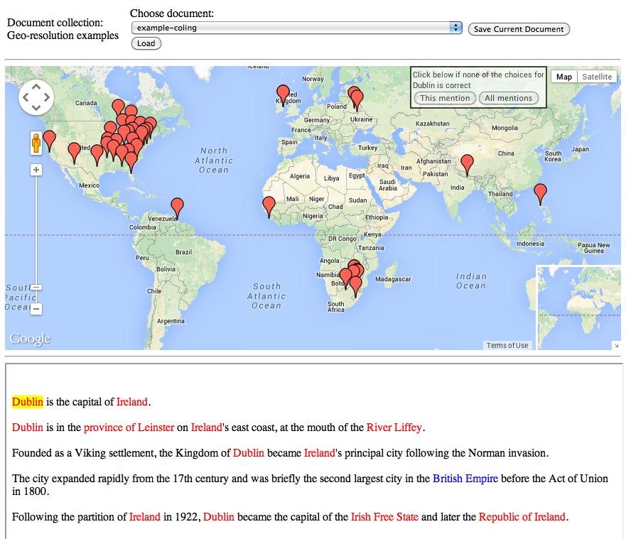
13 Step 1: Geotagging Named Entity Recognition location mentions Also finds person, date/time expressions, organisation Rule-based, uses syntactic and semantic clues in context 9
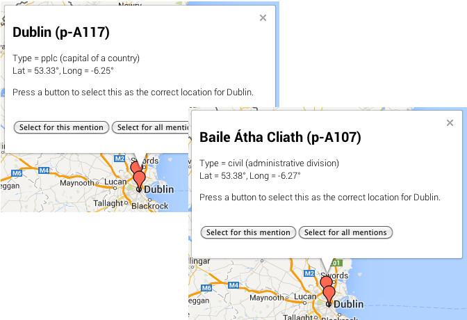
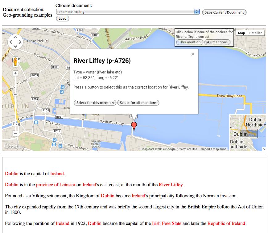
14 Step 2: Georesolution Ground location mentions against one or more gazetteers Prefer populated places Prefer locations closer to others mentioned in document. 10

15 Step 2: Georesolution Ground location mentions against one or more gazetteers Prefer populated places Prefer locations closer to others mentioned in document. Document is about USA. Prefer Paris,Texas to Paris,France. 10
16 Putting it all together: How GapVis Works classical texts from Google Books 11
17 Putting it all together: How GapVis Works classical texts from Google Books Edinburgh Geoparser 11
18 Putting it all together: How GapVis Works classical texts from Google Books Pleiades gazetteer of ancient places Edinburgh Geoparser 11
19 Putting it all together: How GapVis Works classical texts from Google Books Pleiades gazetteer of ancient places Edinburgh Geoparser database of toponym URIs tied back to text snippets 11
20 Putting it all together: How GapVis Works classical texts from Google Books Pleiades gazetteer of ancient places Edinburgh Geoparser database of toponym URIs tied back to text snippets finding relationships between places 11

21 Putting it all together: How GapVis Works classical texts from Google Books Pleiades gazetteer of ancient places Edinburgh Geoparser putting it all together GapVis database of toponym URIs tied back to text snippets finding relationships between places 11
22 GapVis is still evolving Forks and Re-use GAP2 the Geographic Annotation Platform Hestia2: Used in undergraduate teaching Includes Greek original Related projects: Pelagios, Perseus, Perseids Journey of the Hero people network as well as places hand-annotated by students in coursework 12

23 Perseids Journey of the Hero 13
24 Evaluation We like it, but is it good? Traditional NLP evaluation against Gold Standard Qualitative evaluation use in coursework 14
25 Using a hand-annotated Gold Standard Geotagging Precision: were tokens we tagged actually places? Recall: how many did we miss? F-score: harmonic mean of P and R Georesolution: placenames correctly located? Varies considerably across domains 15
26 Using a hand-annotated Gold Standard Geotagging Precision: were tokens we tagged actually places? Recall: how many did we miss? F-score: harmonic mean of P and R Georesolution: placenames correctly located? Varies considerably across domains Geotagging: F-score; Georesolution: 69-92% Richard Tobin, Claire Grover, Kate Byrne, James Reid and Jo Walsh. (2010) Evaluation of georeferencing. In Proceedings of the 6th Workshop on Geographic Information Retrieval (GIR10), Zurich, Switzerland, Feb
27 Evaluation in Coursework GapVis used in 2 undergraduate Classics courses. hestia.open.ac.uk/reading-herodotus-spatially-in-the-undergraduate-classroom-part-i hestia.open.ac.uk/reading-herodotus-spatially-in-the-undergraduate-classroom-part-ii hestia.open.ac.uk/reading-herodotus-spatially-in-the-undergraduate-classroom-part-iii Visualisations of time and space help You can ask different questions Digital doesn t necessarily mean easier Adam Rabinowitz, University of Texas, Austin 16
28 1 Google Ancient Places and GapVis The GAP year How GapVis Works Evaluation 2 Language Technology Group Recent georeferencing projects Problems, issues, lessons learned 17
29 Recent LTG georeferencing projects DEEP: Digital Exposure of English Placenames Trading Consequences: 19th Century commodity trading Palimpsest: an Edinburgh literature landscape 18
30 Recent LTG georeferencing projects DEEP: Digital Exposure of English Placenames Trading Consequences: 19th Century commodity trading Palimpsest: an Edinburgh literature landscape Natural Language Processing over historical and cultural documents, with Humanities partners 18

31 Palimpsest Edinburgh-related fiction from British Library, Hathi Trust, Project Gutenberg, NLS, etc 550 books Created a fine-grained gazetteer of Edinburgh Visualise geo-located snippets of text 19

32 Palimpsest online interface: LitLong 20
33 Problems, issues, lessons learned New domains, new problems newswire, classics, fiction... OCR issues!! TEI does not enforce well-formed XML No standard document structure Only as good as the gazetteer Distinguishing Places from People Paris, Priam, [Earl of] Montrose,... 21
34 OCR issues Around the World in Eighty Days 22

35 Assisted Curation Edinburgh Geo-annotator 23
36 24
37 25
38 26
39 Conclusions Visualisations of space and time give new perspectives 27
40 Conclusions Visualisations of space and time give new perspectives Tailoring for each new domain is required 27
41 Conclusions Visualisations of space and time give new perspectives Tailoring for each new domain is required Automated NLP is fast, but not perfect 27
42 Conclusions Visualisations of space and time give new perspectives Tailoring for each new domain is required Automated NLP is fast, but not perfect Quality of copyright-free material often poor 27
43 Conclusions Visualisations of space and time give new perspectives Tailoring for each new domain is required Automated NLP is fast, but not perfect Quality of copyright-free material often poor Often need specialist gazetteers 27
44 Conclusions Visualisations of space and time give new perspectives Tailoring for each new domain is required Automated NLP is fast, but not perfect Quality of copyright-free material often poor Often need specialist gazetteers Collaboration between different disciplines essential 27
45 28
A Web-based Geo-resolution Annotation and Evaluation Tool
 A Web-based Geo-resolution Annotation and Evaluation Tool Beatrice Alex, Kate Byrne, Claire Grover and Richard Tobin School of Informatics University of Edinburgh {balex,kbyrne3,grover,richard}@inf.ed.ac.uk
Enhancing the Curation of Botanical Data Using Text Analysis Tools
 Enhancing the Curation of Botanical Data Using Text Analysis Tools Clare Llewellyn 1,ClareGrover 1, Jon Oberlander 1,andElspethHaston 2 1 University of Edinburgh, Edinburgh, United Kingdom C.A.Llewellyn@sms.ed.ac.uk,
Automated Geoparsing of Paris Street Names in 19th Century Novels
 Automated Geoparsing of Paris Street Names in 19th Century Novels L. Moncla, M. Gaio, T. Joliveau, and Y-F. Le Lay L. Moncla ludovic.moncla@ecole-navale.fr GeoHumanities 17 L. Moncla GeoHumanities 17 2/22
Pelagios Commons. Finding the Geography in History
 Pelagios Commons Finding the Geography in History Leif Isaksen, Lancaster University Elton Barker, The Open University Rainer Simon, Austrian Institute of Technology Pau de Soto, Institute of Catalan Studies
Pelagios Semantic Annotation of Historical Place References in Digital Resources
 Pelagios Semantic Annotation of Historical Place References in Digital Resources Rainer Simon, Austrian Institute of Technology Andrew Lindley, Austrian Institute of Technology Leif Isaksen, University
Citation for published version (APA): Andogah, G. (2010). Geographically constrained information retrieval Groningen: s.n.
: Andogah, G. (2010). Geographically constrained information retrieval Groningen: s.n.") University of Groningen Geographically constrained information retrieval Andogah, Geoffrey IMPORTANT NOTE: You are advised to consult the publisher's version (publisher's PDF) if you wish to cite from
University of Groningen Geographically constrained information retrieval Andogah, Geoffrey IMPORTANT NOTE: You are advised to consult the publisher's version (publisher's PDF) if you wish to cite from
Dynamic Ontology Service for Historical Persons and Places Based on Crowdsourcing
 Dynamic Ontology Service for Historical Persons and Places Based on Crowdsourcing 22.1.2016, COST RRL WG2 Workshop Jouni Tuominen Semantic Computing Research Group (SeCo), http://seco.cs.aalto.fi, Aalto
GIS Visualization: A Library s Pursuit Towards Creative and Innovative Research
 GIS Visualization: A Library s Pursuit Towards Creative and Innovative Research Justin B. Sorensen J. Willard Marriott Library University of Utah justin.sorensen@utah.edu Abstract As emerging technologies
Creating a Definitive Place Name Gazetteer for Scotland. Bruce M. Gittings
 Creating a Definitive Place Name Gazetteer for Scotland Bruce M. Gittings School of GeoSciences, University of Edinburgh, Edinburgh, UK bruce@ed.ac.uk Place-names represent a fundamental geographical identifier,
ChemDataExtractor: A toolkit for automated extraction of chemical information from the scientific literature
 : A toolkit for automated extraction of chemical information from the scientific literature Callum Court Molecular Engineering, University of Cambridge Supervisor: Dr Jacqueline Cole 1 / 20 Overview 1
How a Media Organization Tackles the. Challenge Opportunity. Digital Gazetteer Workshop December 8, 2006
 A Case-Study-In-Process: How a Media Organization Tackles the Georeferencing Challenge Opportunity Digital Gazetteer Workshop December 8, 2006 to increase and diffuse geographic knowledge 1888 to 2006:
Explore. history landscapes family.
 Explore history landscapes family www.explorethepast.co.uk Contents From the team Section 1 Researching Worcestershire Section 2 Local Studies & Archaeology Reference Library Section 3 Maps and plans Accessing
A Data Repository for Named Places and Their Standardised Names Integrated With the Production of National Map Series
 A Data Repository for Named Places and Their Standardised Names Integrated With the Production of National Map Series Teemu Leskinen National Land Survey of Finland Abstract. The Geographic Names Register
19.2 Geographic Names Register General The Geographic Names Register of the National Land Survey is the authoritative geographic names data
 Section 7 Technical issues web services Chapter 19 A Data Repository for Named Places and their Standardised Names Integrated with the Production of National Map Series Teemu Leskinen (National Land Survey
Pleiades: Beyond the Barrington Atlas. Richard Talbert, principal investigator Sean Gillies, chief engineer
 Pleiades: Beyond the Barrington Atlas Richard Talbert, principal investigator Sean Gillies, chief engineer Pleiades Project, Ancient World Mapping Center University of North Carolina at Chapel Hill, U.S.A.
The Importance of Spatial Literacy
 The Importance of Spatial Literacy Dr. Michael Phoenix GIS Education Consultant Taiwan, 2009 What is Spatial Literacy? Spatial Literacy is the ability to be able to include the spatial dimension in our
Further frontiers in GIS: Extending spatial analysis to textual sources in Archaeology
 Further frontiers in GIS: Extending spatial analysis to textual sources in Archaeology Patricia Murrieta-Flores and Ian Gregory History & Archaeology Department, University of Chester. p.murrietaflores@chester.ac.uk
Principles of IR. Hacettepe University Department of Information Management DOK 324: Principles of IR
 Principles of IR Hacettepe University Department of Information Management DOK 324: Principles of IR Some Slides taken from: Ray Larson Geographic IR Overview What is Geographic Information Retrieval?
1 Archaeology, space, GIS and texts
 Open Archaeology 2015; 1: 166 175 Original Study Open Access Patricia Murrieta-Flores*, Ian Gregory Further Frontiers in GIS: Extending Spatial Analysis to Textual Sources in Archaeology Abstract: Although
December 3, Dipartimento di Informatica, Università di Torino. Felicittà. Visualizing and Estimating Happiness in
 : : Dipartimento di Informatica, Università di Torino December 3, 2013 : Outline : from social media Social media users generated contents represent the human behavior in everyday life, but... how to analyze
Subject: Geography Scheme of Work: B1 to B6 Mastery tiles. Term: Autumn/Spring/Summer
 Subject: Geography Scheme of Work: B1 to B6 Mastery tiles Term: Autumn/Spring/Summer Topic / Unit(s) Overview / Context Introduction to geography. An introduction to geography including basic map skills
Geographic Analysis of Linguistically Encoded Movement Patterns A Contextualized Perspective
 Geographic Analysis of Linguistically Encoded Movement Patterns A Contextualized Perspective Alexander Klippel 1, Alan MacEachren 1, Prasenjit Mitra 2, Ian Turton 1, Xiao Zhang 2, Anuj Jaiswal 2, Kean
A spatial literacy initiative for undergraduate education at UCSB
 A spatial literacy initiative for undergraduate education at UCSB Mike Goodchild & Don Janelle Department of Geography / spatial@ucsb University of California, Santa Barbara ThinkSpatial Brown bag forum
What are we like? Population characteristics from UK censuses. Justin Hayes & Richard Wiseman UK Data Service Census Support
 What are we like? Population characteristics from UK censuses Justin Hayes & Richard Wiseman UK Data Service Census Support Who are we? Richard Wiseman UK Data Service / Jisc Justin Hayes UK Data Service
Geospatial Services in Special Libraries: A Needs Assessment Perspective
 Purdue University Purdue e-pubs Libraries Faculty and Staff Scholarship and Research Purdue Libraries 5-17-2013 Geospatial Services in Special Libraries: A Needs Assessment Perspective Ilana R. Barnes
Changes in the sky Earth and Space Sciences Written for the Australian Curriculum: Science
 Changes in the sky Earth and Space Sciences Written for the Australian Curriculum: Science Sienna Osborne Randall Hall Richard John AUSTRALIAN CURRICULUM: SCIENCE Strand: Sub-strand: Descriptor: Science
TEMPLATE FOR CMaP PROJECT
 TEMPLATE FOR CMaP PROJECT Project Title: Native Utah Plants Created by: Anna Davis Class: Box Elder 2008 Project Description Community Issue or Problem Selected -How project evolved? Community Partner(s)
Dynamic Maps and Historical Context
 Dynamic Maps and Historical Context Jeanette Zerneke International Joint GIS-IDEAS and PNC/ECAI Conference December 2008 Dynamic Maps Roles and Functions of Dynamic Maps in Cultural Collections and Atlases
The SyMoGIH project and Geo-Larhra: A method and a collaborative platform for a digital historical atlas
 The SyMoGIH project and Geo-Larhra: A method and a collaborative platform for a digital historical atlas Francesco Beretta, Claire-Charlotte Butez To cite this version: Francesco Beretta, Claire-Charlotte
Spatializing time in a history text corpus
 Zurich Open Repository and Archive University of Zurich Main Library Strickhofstrasse 39 CH-8057 Zurich www.zora.uzh.ch Year: 2014 Spatializing time in a history text corpus Bruggmann, André; Fabrikant,
A Map Through Time Virtual Historic Cities
 A Map Through Time Virtual Historic Cities NEW WAYS OF EXPLORING DIGITAL COLLECTIONS FLORIDA INTERNATIONAL UNIVERSITY JAMIE ROGERS Coral Gables Virtual Historic City & Unearthing St. Augustine s Colonial
A Hierarchical, Multi-modal Approach for Placing Videos on the Map using Millions of Flickr Photographs
 A Hierarchical, Multi-modal Approach for Placing Videos on the Map using Millions of Flickr Photographs Pascal Kelm Communication Systems Group Technische Universität Berlin Germany kelm@nue.tu-berlin.de
A geo-temporal information extraction service for processing descriptive metadata in digital libraries
 B. Martins, H. Manguinhas *, J. Borbinha *, W. Siabato A geo-temporal information extraction service for processing descriptive metadata in digital libraries Keywords: Georeferencing; gazetteers; geoparser;
Assessing pervasive user-generated content to describe tourist dynamics
 Assessing pervasive user-generated content to describe tourist dynamics Fabien Girardin, Josep Blat Universitat Pompeu Fabra, Barcelona, Spain {Fabien.Girardin, Josep.Blat}@upf.edu Abstract. In recent
MIDDLE TENNESSEE STATE UNIVERSITY Global Studies / Cultural Geography Major Matrix Page 1 of 7
 Page 1 of 7 I. Social Studies Core GS 4990 (3) Senior Seminar in Global Studies SSC 1. Demonstrate critical thinking in the social sciences by GEOG 2000 (1/3) Introduction to Regional Geography posing
THE PAST AND PRESENT STATE OF DIGITAL HISTORY
 THE PAST AND PRESENT STATE OF DIGITAL HISTORY Dara Folan Ollscoil na héireann,gaillimh/ NUI Galway FINDING NEW WAYS TO ANALYZE THE PAST ADDING LAYERS OF UNDERSTANDING DEFINING DIGITAL HUMANITIES Lou Burnard
Design and Development of a Large Scale Archaeological Information System A Pilot Study for the City of Sparti
 INTERNATIONAL SYMPOSIUM ON APPLICATION OF GEODETIC AND INFORMATION TECHNOLOGIES IN THE PHYSICAL PLANNING OF TERRITORIES Sofia, 09 10 November, 2000 Design and Development of a Large Scale Archaeological
Middle School. Teacher s Guide MICROPLANTS MAJOR SPONSOR:
 Middle School Teacher s Guide MICROPLANTS MAJOR SPONSOR: Introduction As technology continues to rapidly evolve, scientists are able to collect and store more data. Some scientists find themselves with
Understanding and accessing 2011 census aggregate data
 Understanding and accessing 2011 census aggregate data 4 July 11:00 to 16:00 BST Justin Hayes and Richard Wiseman UK Data Service Census Support UK censuses provide an unparalleled resource of high quality
DIGITAL LIBRARY INTRODUCTION FOR TEACHERS COMPILED BY LINDA ROCHE, FAIRFAX HIGH SCHOOL TEACHER LIBRARIAN
 DIGITAL LIBRARY INTRODUCTION FOR TEACHERS COMPILED BY LINDA ROCHE, FAIRFAX HIGH SCHOOL TEACHER LIBRARIAN LAUSD Digital Library, not to be confused with SBAC Digital Library, is a collection of subscription
National Geographic World English 2 Workbook Answers
 We have made it easy for you to find a PDF Ebooks without any digging. And by having access to our ebooks online or by storing it on your computer, you have convenient answers with national geographic
CLRG Biocreative V
 CLRG ChemTMiner @ Biocreative V Sobha Lalitha Devi., Sindhuja Gopalan., Vijay Sundar Ram R., Malarkodi C.S., Lakshmi S., Pattabhi RK Rao Computational Linguistics Research Group, AU-KBC Research Centre
Seymour Centre 2017 Education Program 2071 CURRICULUM LINKS
 Suitable for: Stage 5 Stage 6 HSC Subject Links: Seymour Centre 2017 Education Program 2071 CURRICULUM LINKS Science Stage Content Objective Outcomes Stage 5 Earth and Space ES3: People use scientific
Algebra II. Unit 2 Suggested Time Frame. Analyzing Functions and Absolute Value. 19 Days
 Title Analyzing Functions and Absolute Value Big Ideas/Enduring Understandings Functions can be used to show various forms of information, both conceptual and real world, to help understand what is being
Brian D. George. GIMS Specialist Ohio Coastal Atlas Project Coordinator and Cartographer. Impacts and Outcomes of Mature Coastal Web Atlases
 Ohio Coastal Atlas Project Brian D. George GIMS Specialist Ohio Coastal Atlas Project Coordinator and Cartographer Ohio Department of Natural Resources Office of Coastal Management Sandusky, OH Impacts
Where do I live? Geography teaching resource. Paula Owens. Primary. Locating own home address
 Where do I live? Locating own home address Paula Owens Geography teaching resource Primary Digimap for Schools Geography Resources Where do I live Level Context Location Primary Locating own home address
Master Syllabus Department of Geography GEOG 121: Geography of the Cultural Environment Course Description
 Master Syllabus Department of Geography GEOG 121: Geography of the Cultural Environment Course Description Geography of the Cultural Environment utilizes qualitative methods to investigate relationships
Semantics, ontologies and escience for the Geosciences
 Semantics, ontologies and escience for the Geosciences Femke Reitsma¹, John Laxton², Stuart Ballard³, Werner Kuhn, Alia Abdelmoty ¹femke.reitsma@ed.ac.uk: School of Geosciences, Edinburgh University ²
Section 12 2 Newton S First And Second Laws Of Motion Guided Reading Worksheet Answeres
 Section 12 2 Newton S First And Second Laws Of Guided Reading Worksheet Answeres Free PDF ebook Download: Section 12 2 Newton S First And Second Laws Of Guided Reading Worksheet Answeres Download or Read
HANDLING UNCERTAINTY IN INFORMATION EXTRACTION
 HANDLING UNCERTAINTY IN INFORMATION EXTRACTION Maurice van Keulen and Mena Badieh Habib URSW 23 Oct 2011 INFORMATION EXTRACTION Unstructured Text Information extraction Web of Data Inherently imperfect
Contextualizing Historical Places in a Gazetteer by Using Historical Maps and Linked Data
 Contextualizing Historical Places in a Gazetteer by Using Historical Maps and Linked Data Esko Ikkala, Jouni Tuominen, and Eero Hyvönen Semantic Computing Research Group (SeCo), Aalto University http://www.seco.tkk.fi/,
European geography and what it can do for the future: the case of a bi-communal project in divided Cyprus
 European geography and what it can do for the future: the case of a bi-communal project in divided Cyprus Stavroula Philippou Assistant Professor (Curriculum & Instruction) Department of Education Sciences
From Research Objects to Research Networks: Combining Spatial and Semantic Search
 From Research Objects to Research Networks: Combining Spatial and Semantic Search Sara Lafia 1 and Lisa Staehli 2 1 Department of Geography, UCSB, Santa Barbara, CA, USA 2 Institute of Cartography and
Edexcel B GCSE Geography Course Options
 Edexcel B GCSE Geography Course Options For teaching from September 2016 Juniper Hall is an amazing location for fieldwork, set in a quiet wooded valley in an unspoilt area of the chalk North Downs at
Newspaper archives + text mining = rich sources of historical geo-spatial data
 IOP Conference Series: Earth and Environmental Science PAPER OPEN ACCESS Newspaper archives + text mining = rich sources of historical geo-spatial data To cite this article: A Yzaguirre et al 2016 IOP
Assessment Management. Math Boxes 7 3. Math Journal 2, p. 218 Students practice and maintain skills through Math Box problems.
 Scientific Notation Objective To introduce scientific notation. www.everydaymathonline.com epresentations etoolkit Algorithms Practice EM Facts Workshop Game Family Letters Assessment Management Common
Plants Biological Sciences Written for the Australian Curriculum: Science
 Plants Biological Sciences Written for the Australian Curriculum: Science Sienna Osborne Randall Hall Richard John AUSTRALIAN CURRICULUM: SCIENCE Strand: Sub-strand: Descriptor: SCIENCE WORDS Science Understanding
St. Pölten University of Applied Sciences. Strategy St. Pölten University of Applied Sciences. fhstp.ac.at
 St. Pölten University of Applied Sciences Strategy 2021 St. Pölten University of Applied Sciences fhstp.ac.at St. Pölten UAS: My best place Our vision St. Pölten University of Applied Sciences (St. Pölten
Major Languages of the Americas
 Your web browser (Safari 7) is out of date. For more security, comfort and Activitydevelop the best experience on this site: Update your browser Ignore Major Languages of the Americas How are languages
Extraction of Spatio-Temporal data about Historical events from text documents
 Faculty of Environmental Sciences, Department of Geosciences, Chair of Geoinformatics Extraction of Spatio-Temporal data about Historical events from text documents Case Study: German-Herero war of resistance
Large Scale Evaluation of Chemical Structure Recognition 4 th Text Mining Symposium in Life Sciences October 10, Dr.
 Large Scale Evaluation of Chemical Structure Recognition 4 th Text Mining Symposium in Life Sciences October 10, 2006 Dr. Overview Brief introduction Chemical Structure Recognition (chemocr) Manual conversion
UC Berkeley International Conference on GIScience Short Paper Proceedings
 UC Berkeley International Conference on GIScience Title Deriving Locational Reference through Implicit Information Retrieval Permalink https://escholarship.org/uc/item/0tn5s4v9 Journal International Conference
Exploring Urban Areas of Interest. Yingjie Hu and Sathya Prasad
 Exploring Urban Areas of Interest Yingjie Hu and Sathya Prasad What is Urban Areas of Interest (AOIs)? What is Urban Areas of Interest (AOIs)? Urban AOIs exist in people s minds and defined by people s
Geofacets EDUCATION & RESEARCH
 EDUCATION & RESEARCH Geofacets In academic institutions, geoscience departments are tasked with producing high-quality research, instilling best practice research principles in students, and preparing
Spatial Data Management of Bio Regional Assessments Phase 1 for Coal Seam Gas Challenges and Opportunities
 Spatial Data Management of Bio Regional Assessments Phase 1 for Coal Seam Gas Challenges and Opportunities By Dr Zaffar Sadiq Mohamed-Ghouse Principal Consultant, Spatial & IT, GHD zaffar.sadiq@ghd.com
Sample assessment task. Task details. Content description. Year level 7
 Sample assessment task Year level 7 Learning area Subject Title of task Task details Description of task Type of assessment Purpose of assessment Assessment strategy Evidence to be collected Suggested
Trading Consequences: A Case Study of Combining Text Mining and Visualization to Facilitate Document Exploration
 Trading Consequences: A Case Study of Combining Text Mining and Visualization to Facilitate Document Exploration... Uta Hinrichs SACHI Group, School of Computer Science, University of St Andrews, UK Beatrice
Geospatial Intelligence
 Geospatial Intelligence Geospatial analysis has existed as long as humans have made and studied maps but its importance to the intelligence community has skyrocketed in the past several years, with Unmanned
Amount of Substance and Its Unit Mole- Connecting the Invisible Micro World to the Observable Macro World Part 2 (English, mp4)
") Amount of Substance and Its Unit Mole- Connecting the Invisible Micro World to the Observable Macro World Part 2 (English, mp4) [MUSIC PLAYING] Instructor: Hi, everyone. Welcome back. I hope you had some
Amount of Substance and Its Unit Mole- Connecting the Invisible Micro World to the Observable Macro World Part 2 (English, mp4) [MUSIC PLAYING] Instructor: Hi, everyone. Welcome back. I hope you had some
GIS PORTFOLIO MOHAMED MAGDY MOHAMED HUSSAIN GIS ENGINEER. UWF GIS ONLINE CERTIFICATE GIS Internship (GIS4944)
") 2012 GIS PORTFOLIO MOHAMED MAGDY MOHAMED HUSSAIN GIS ENGINEER UWF GIS ONLINE CERTIFICATE GIS Internship (GIS4944) Portfolio Table of Contents Subject... Page Personal statement/mission/philosophy... 1
2012 GIS PORTFOLIO MOHAMED MAGDY MOHAMED HUSSAIN GIS ENGINEER UWF GIS ONLINE CERTIFICATE GIS Internship (GIS4944) Portfolio Table of Contents Subject... Page Personal statement/mission/philosophy... 1
Creating A-16 Compliant National Data Theme for Cultural Resources
 Creating A-16 Compliant National Data Theme for Cultural Resources Cultural Resource GIS Facility National Park Service John J. Knoerl Deidre McCarthy Paper 169 Abstract OMB Circular A-16 defines a set
Archaeology & Digital Humanities
 WAYNE STATE UNIVERSITY Archaeology & Digital Humanities The D.I.R.T. on Big Data STRENGTHENING THE BIG DATA & ANALYTICS ECOSYSTEM WAYNE STATE UNIVERSITY Krysta Ryzewski Associate Professor of Anthropology
A level Geography. WG6 Induction 2015
 A level Geography WG6 Induction 2015 What general employment skills will A level Geography give you? A good communicator with strong presentation skills Competent IT skills An independent researcher Able
Underground Railroad Grades 6-8. Time Frame: 1-3 class periods, depending on the extent of outside research
 Underground Railroad Grades 6-8 Introduction This activity is intended for students who have already learned about slavery and are currently studying the Underground Railroad. They ll compare a map of
Treasury Of Norse Mythology Stories Of Intrigue Trickery Love And Revenge Mythology
 Treasury Of Norse Mythology Stories Of Intrigue Trickery Love And Revenge Mythology We have made it easy for you to find a PDF Ebooks without any digging. And by having access to our ebooks online or by
MEP: Demonstration Project Unit 2: Formulae
 UNIT Formulae NC: Algebra 3a, b, c TOPICS (Text and Practice Books) St Ac Ex Sp.1 Using Formulae - - -.1 Construct and Use Simple Formula - -.3 Revision of Negative Numbers - - -.4 Substitutions with Formula.5
The Establishment of a Database on Current Research in UNESCO Biosphere Reserves: Limitations and Opportunities
 The Establishment of a Database on Current Research in UNESCO Biosphere Reserves: Limitations and Opportunities Pamela Shaw a* Martin F. Price b Taylor Alexander a Rushi Gadoya a Graham Sakaki a Lauren
An Alternate Career Choice for the Geography Major: Map, GIS, or Geographic Information Librarianship
 An Alternate Career Choice for the Geography Major: Map, GIS, or Geographic Information Librarianship Katherine H. Weimer Texas A&M University Libraries SWAAG 2007 - Bryan, Texas Overview of today s talk
Stellar Astronomy 1401 Spring 2009
 Stellar Astronomy 1401 Spring 2009 Instructor: Ron Wilhelm Office: Science Building Room 9 Contact information: Office Hours: 742-4707 or ron.wilhelm@ttu.edu MWF 10:00-11:00 PM T & Th 11:30-12:30 AM Or
GIS Institute Center for Geographic Analysis
 GIS Institute Center for Geographic Analysis Welcome Intensive training in the application of GIS to research Collection, management, analysis, and communication of spatial data Topics include: data collection,
Wisconsin Academic Standards Science Grade: 8 - Adopted: 1998
 Main Criteria: Wisconsin Academic Standards Secondary Criteria: Subjects: Science, Social Studies Grade: 8 Correlation Options: Show Correlated Wisconsin Academic Standards Science Grade: 8 - Adopted:
River Dell Regional School District. Algebra I Curriculum
 Algebra I Curriculum 2015 Mr. Patrick Fletcher Superintendent River Dell Regional Schools Ms. Lorraine Brooks Principal River Dell High School Mr. Richard Freedman Principal River Dell Middle School Mr.
Sample file. Copyright 2002, 2003, 2005, 2006, 2009 Cindy Wiggers Revised 2006 Published by Geography Matters, Inc
 Copyright 2002, 2003, 2005, 2006, 2009 Cindy Wiggers Revised 2006 Published by Geography Matters, Inc Cover design by Alex Wiggers Photography by Kim Whitmore-Weber All rights reserved. No part of this
Glossary of Common Terms. Guide 2. BAJR Practical Guide Series held by authors
 Glossary of Common Terms Guide 2 BAJR Practical Guide Series 2008 held by authors Glossary of common archaeological terms : compiled 28/04/2004 absolute dating: Absolute dating is based upon a specific
Approximately 45 minutes
 Lab Activity Title: Mole Day Submitted by: Pam Kraus Recommended Grade Level: 11 Discipline: Chemistry Topic: Mole Day Time Requirement: Approximately 45 minutes Required Materials: Copies of Mole contest
33 par&cipants 16 countries 5 sessions 16 presenta&ons
 33 par&cipants 16 countries 5 sessions 16 presenta&ons Collection development, facts, figures and trends DUTCH EXPERIENCES rich tradition of institutional map collecting, dating back already to the 16th
DATA ACQUISITION FROM BIO-DATABASES AND BLAST. Natapol Pornputtapong 18 January 2018
 DATA ACQUISITION FROM BIO-DATABASES AND BLAST Natapol Pornputtapong 18 January 2018 DATABASE Collections of data To share multi-user interface To prevent data loss To make sure to get the right things
Moon's Orbit ACTIVITY OVERVIEW NGSS CONNECTIONS NGSS CORRELATIONS
 5 The Moon's Orbit m o d e l i n g 1 2 c l a s s sessions ACTIVITY OVERVIEW NGSS CONNECTIONS Students develop and use a three-dimensional model that illustrates how the Moon s orbital plane is not aligned
CHEMISTRY MATTER AND CHANGE TEACHER EDITION PDF
 CHEMISTRY MATTER AND CHANGE TEACHER EDITION PDF ==> Download: CHEMISTRY MATTER AND CHANGE TEACHER EDITION PDF CHEMISTRY MATTER AND CHANGE TEACHER EDITION PDF - Are you searching for Chemistry Matter And
The What and Why of UTM Synergy 4.0
 The What and Why of UTM Synergy 4.0 What is UTM Synergy 4.0? UTM ACADEMIC ERAS UTM Synergy 4.0 [2018] Research University (RU) [2010] UTM 3.0 RU & RA Research Alliance Consolidation [2015] Broad- Based
Chemistry with Spanish for Science
 Programme Specification (Undergraduate) Chemistry with Spanish for Science This document provides a definitive record of the main features of the programme and the learning outcomes that a typical student
Developing Cross-cultural Education Programs
 Developing Cross-cultural Education Programs Kathy Bertram Director, Education Outreach Office Geophysical Institute University of Alaska Fairbanks Communicating Science in Native Cultures Alaska Native
Grade 5 Social Studies Curriculum Map Mrs. Ward. Standards. Standards. # Course Outcomes Course Outcome
 Grade 5 Social Studies Curriculum Map 2015 2016 Mrs. Ward # Course Outcomes Course Outcome Standards Standards 1 SWBAT construct timelines, tables, charts, maps and graph to represent and interpret historical
The maps in this resource can be freely modified and reproduced in the classroom only.
 Teacher's Notes In this activity, students work collaboratively to explore sections of old and new maps. By closely examining these documents, students learn to see maps as more than just tools for locating
Measuring topographic similarity of toponyms
 Measuring topographic similarity of toponyms Curdin Derungs Department of Geography University of Zürich Winterthurerstr. 190 8057 Zürich, Switzerland curdin.derungs@geo.uzh.ch Ross S. Purves Department
Geography Policy. for Hertsmere Jewish Primary School
 Geography Policy for Hertsmere Jewish Primary School Reviewed by: L Rubin Reviewed on: September 2017 Date of Next Review: September 2018 Policy Review This policy will be reviewed in full by the Governing
State and National Standard Correlations NGS, NCGIA, ESRI, MCHE
 GEOGRAPHIC INFORMATION SYSTEMS (GIS) COURSE DESCRIPTION SS000044 (1 st or 2 nd Sem.) GEOGRAPHIC INFORMATION SYSTEMS (11, 12) ½ Unit Prerequisite: None This course is an introduction to Geographic Information
Resources for Treasure Hunt In Earth s Attic Try This!
 Try This! Work in groups or as a family to determine the order of events that in the history of the Earth and Moon. More information and graphics are available at http://www.lpi.usra.edu/education/timeline/introduction.shtml
Montana Content Standards Science Grade: 6 - Adopted: 2016
 Main Criteria: Montana Content Standards Secondary Criteria: Subjects: Science, Social Studies Grade: 6 Correlation Options: Show Correlated MT.6-8.PS. BENCHMARK / STANDARD 6-8.PS.3. MT.6-8.LS. BENCHMARK
Literary Geographies, Past and Future. Sheila Hones. The University of Tokyo
 1 THINKING SPACE Thinking Space is a series of short position papers on key terms and concepts for literary geography. Cumulatively, these accessible and wide-ranging pieces will explore the scope, parameters,