Predicting Archaeological Site Locations Using G.I.S. and Fuzzy Logic
|
|
|
- Gloria Morris
- 5 years ago
- Views:
Transcription
1 Doerr, Martin and Apostolis Sarris (eds) The Digital Heritage of Archaeology. CAA2002. Computer Applications and Quantitative Methods in Archaeology. Proceedings of the 30th CAA Conference, Heraklion, Crete, April Predicting Archaeological Site Locations Using G.I.S. and Fuzzy Logic Eugenia Hatzinikolaou Department of Geography and Regional Planning National Technical University of Athens Technical University Campus, Zographou, Athens Tel. : gina@central.ntua.gr Thomas Hatzichristos Department of Geography and Regional Planning National Technical University of Athens Technical University Campus, Zographou, Athens Tel. : thomasx@survey.ntua.gr Angelos Siolas Department of Geography and Regional Planning National Technical University of Athens Technical University Campus, Zographou, Athens Tel. : angelos@survey.ntua.gr Eleni Mantzourani Department of History and Archaeology University of Athens University Campus - Zographou, Athens Tel: emantzou@arch.uoa.gr Abstract. Techniques for prediction of archaeological site locations have been developed during the past decades as practical tools based on experts knowledge and software s evolution, aiming to an effective cultural resource management. Based on the assumption that the choice of a site s location can be explained by the presence of certain environmental parameters, knowledge from already known archaeological sites, forms the basis in order to predict where else within a region with certain geographical characteristics, phenomena of inhabitance with similar features may have occurred. The likelihood of a site s appearance is crucial in large scale projects planning as well as in a cultural and historical aspect, as precise and small scale archaeological research may miss valuable large scale information and site surveying may be time consuming and not so effective all the time. In this paper, an attempt to use Fuzzy Logic in order to predict possible locations of prehistoric sites is made. The methodology is presented through a case study in Melos, an island of the Western Cyclades - Greece. The data sets extracted from G.I.S analysis are incorporated in a Fuzzy Logic System in order to give the output predictive zones. Keywords. Prediction, G.I.S., Fuzzy Logic 1. Introduction Archaeological research has always been valuable for the preservation of a country s history and culture. Due to its nature, this kind of research must be precise and cautious in order not to destroy what nature has kept so carefully within the years. Small-scale investigation may last for years over spot-areas to reveal all buried artefacts and structures. On the other hand, the constant expansion of our modern world, moving faster day by day, tends to eliminate free spaces not affected by human activities. Moreover, prehistoric archaeological sites are most of the times not visible or easily distinguished since they are buried or mostly destroyed. Based on the above, knowledge of archaeological sites not yet documented, seems crucial in nowadays planning in order to achieve an effective cultural resource management. The need of a methodological tool able to indicate zones determining the potential of a site s occurrence, has lead to the generation of several methodologies of archaeological prediction. New technologies and software s evolution have played an important role to this. Especially, the outburst of Geographical Information Systems and their world wide application have given archaeological analysis a new perspective.(allen et al., (eds.), 1990 ; Lock and Stancic, (eds), 1995). Up to nowadays, several models have been built attempting to classify parts of our world in sites and not sites, opening the way to what has been called predictive modelling and is actually the practice of building models that in some way indicate the likelihood of archaeological sites, cultural resources, or past landscape use across a region (Kvamme, 2001). Generally, these methodologies use a G.I.S package in order to handle geographical data and measure several environmental 169
2 variables, which are tested either by regression analysis or statistical tests for their contribution on a sites and non sites sample. The strongest among them are chosen to participate in the final model s equation, based on which, the rest of the geographical space is going to be classified in sites and non sites accordingly. (Wescott and Brandon, (eds), 2000) Recently, other promising methods, as Multi-Criteria Analysis (Krist, 2001) and Neural Networks, have also entered the predictive modelling world. In this paper, an attempt to use the new science of Fuzzy Logic in archaeological prediction is made. Fuzzy Logic, has been welcomed in many applications. The use of this new science in archaeology seemed a challenge, worth to be taken no matter the result. Known, excavated sites provide the necessary knowledge base, which is the basic element in a Fuzzy Logic system in order to give the final output, which, in this case, is prediction. G.I.S are necessary as they offer a powerful set of tools for the input, the maintenance and the presentation of the data, while the use of Fuzzy Logic is based on the need for appropriately treating environmental phenomena, which are not exact or precise but rather fuzzy. (Karkazi et al., 2001) 2. Using G.I.S and Fuzzy Logic for the Prediction of Archaeological Site Locations The basic assumption in the suggested methodology is that there are archaeological sites in the geographical space that have attributes: they are characterized as settlements or observatories or agricultural units or mining units, or other, and each category is dominated by certain geographical features. However, there is a class overlap, some of the features may exist in all categories to some degree, so certain areas could be either determined as settlements or as agricultural units or else, to a degree. Undoubtedly, only by carrying out an archaeological excavation one can reveal the true identity of a site. By using Fuzzy Logic, this multiple ability of an area to belong in more than one classes can be properly treated. This gives archaeological prediction a new potential, as by defining different types of sites this method can contribute more efficiently in cultural resource management and in an hierarchically driven archaeological survey as well. 2.1 G.I.S: An analytical tool G.I.S. are a box of tools for inserting, handling, and presenting geographical data (Hatzichristos, 1999). In order to predict archaeological site locations, G.I.S. are necessary for the collection of data and the generation of the final data set comprising of all the environmental parameters which will take part in the predictive analysis. As prediction implies a degree of fuzziness itself, the use of Fuzzy Logic for the determination of areas that have a strong potential to be archaeological sites seems ideal as this approach is most suited to applications where decision criteria are not rigid, where the boundary between two regions is gradual. Inexact boundaries or class overlap appear to be more the rule than the exception in geographical problems. (Openshaw, 1997) 2.2 Fuzzy Logic: A New Perspective Classic Boolean logic is binary, meaning that a certain element is true or false, an object belongs to a set or it doesn t. Fuzzy Logic introduced by Zadeh in 1965 permits the notion of nuance. Apart from being true, a proposition may be anything from almost true to hardly true (Kosko, 1991). In comparison with the Boolean sets, a fuzzy set does not have sharply defined boundaries. The notion of a fuzzy set provides a convenient way of dealing with problems in which the source of imprecision is the absence of sharply defined criteria of class membership rather than the presence of random variables. As mentioned, a significant fact about statistical logic is the defect that each point of a set U is unequivocally grouped with other members of its group and thus bears no similarity to members of other groups. One way to characterize an individual point s similarity to all the groups was introduced in 1965 by Zadeh. The key to Zadeh s idea is to represent the similarity a point shares with each group with a function (termed the membership function) whose values (called memberships) are between 0 < m < 1. Each point will have a membership in every group, memberships close to unity signify a high degree of similarity between the point and a group while memberships close to zero imply little similarity between the point and that group. Additionally the sum of the memberships for each point must be unity. Although in Boolean logic A and not A are unique, in Fuzzy Logic the following equation is true: m nota = 1 - m A Fuzzy degrees are not the same as probability percentages. Probabilities measure whether something will occur or not. Fuzziness measures the degree to which something occurs or some condition exists. Crisp sets are a subset to fuzzy sets. Only when an object belongs 100% to a group fuzzy sets are identical to crisp sets. In order to solve a problem with a knowledge-based fuzzy system it is necessary to describe and process the influencing factors in Fuzzy terms and provide the result of this processing in a usable form. The basic elements of a knowledge-based fuzzy system are: 1. Fuzzification 2. Knowledge base 3. Processing 4. Defuzzification These elements are described in detail, in the following paragraphs. Every continuous math function can be approximated by a fuzzy set. For example the criterion distance from a road can be approximated from the following membership function: 170
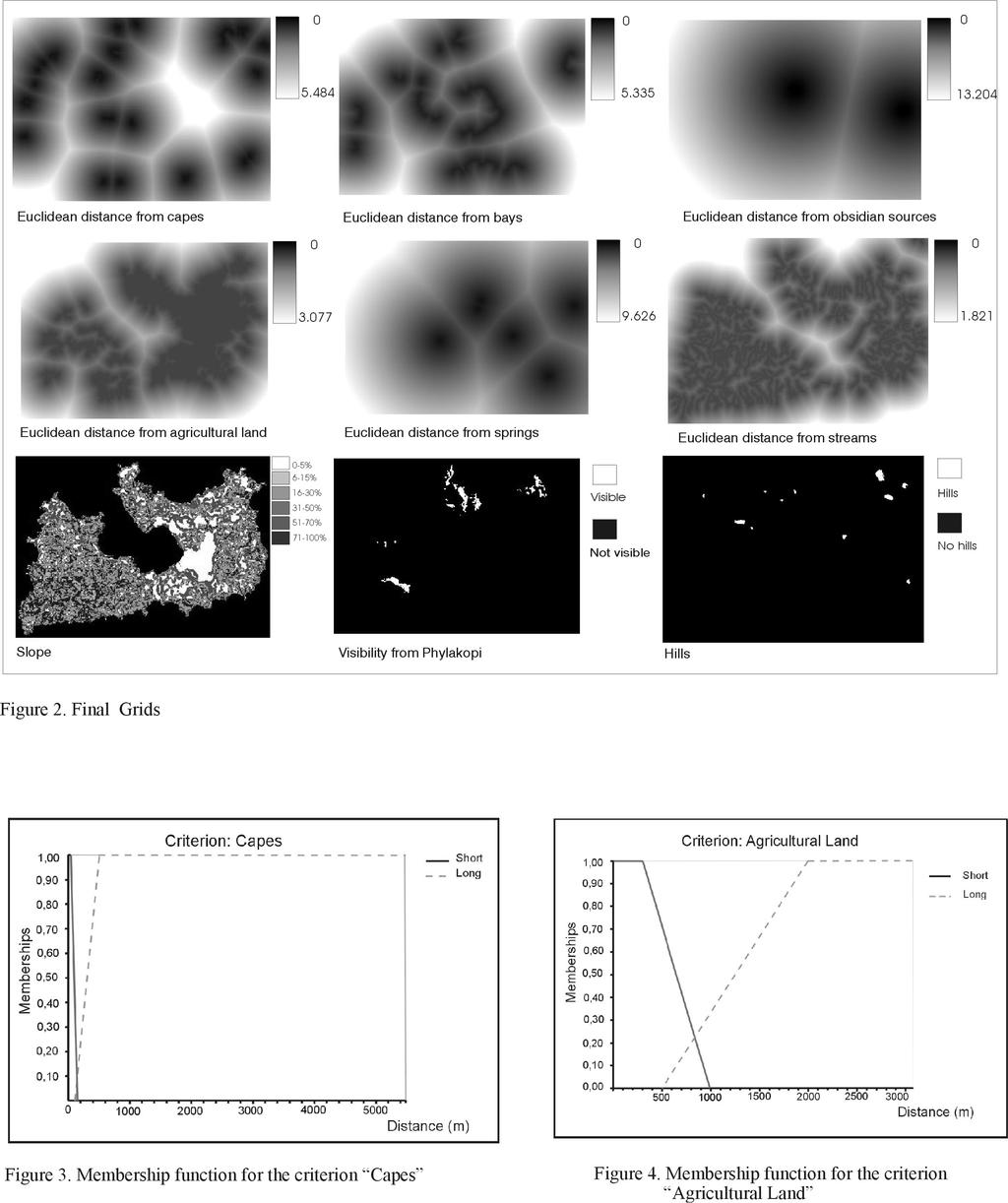
3 Figure 1. Membership function for the distance from a road. Several types of membership functions can be utilized (Bezdek 1981 ; Burrough, 1996). The membership function reflects the knowledge for the specific object or event. The assignment of a membership function to every variable of the problem is called fuzzification process. During this process crisp subsets are transformed to linguistic subsets such as short or long distance (Fig. 1). The concept of the linguistic variable illustrates particularly clearly how fuzzy sets can form the bridge between linguistic expression and numerical information. The second step in the fuzzy systems methodological approach is the definition of the rules, which connect the input to the output. These rules are based on the form if then and. The knowledge in a problem-solving area can be represented by a number of rules. For example, if the output set suitability is comprised by two subsets called poor and appropriate, the rules could be: If the distance is short then suitability is poor If the distance is long then suitability is appropriate Experts with general knowledge on the specific field, usually accomplish the task of rules definition. There is no need for assigning weights in the criteria used. The weights are indirectly taken in account through the rules defined. The next step is the processing of the rules. This step is also called inference. It comprises the three stages, aggregation, implication and accumulation. Aggregation provides the degree of fulfillment for the entire rule concerned. All the Boolean algebra operations (like intersection, union, negation, etc) can be easily extended to fuzzy set operations (Kandel, 1986) and they can be used in this stage. In implication the degree of fulfillment of the conclusion is determined. Accumulation brings together the individual results of the variables used. Details for this process can be found in Bezdek (1981). The result of rules processing can be transformed, if necessary, back into a linguistic expression or a crisp value. This second process is called defuzzification and there are several methods to achieve it (Bezdek, 1981). 5. Case Study: Predicting Prehistoric Site Locations on the Island of Melos Melos is a Greek island stuated at the western Cyclades, a complex of islands in the south Aegean Sea. Special environmental parameters characteristic in all Cycladic islands, as climate, landscape - dominated by the mountains and the sea and natural resources, are present also in Melos. Being a largely volcanic island in addition, Melos played a very significant role in past societies, as it has been the most important obsidian source of the Aegean, supplying not only the neighbor islands but also the mainland of Greece. Moreover, on Melos the town of Phylakopi was discovered, which is up to now the best documented prehistoric site of the Aegean (Renfrew and Wagstaff, (eds), 1982). The island of Melos has been chosen among the other Cycladic islands to realize this pilot research, due to the fact that on Melos an extensive site survey has been carried out during by the British School of Archaeology, offering a valid reference in order to check the results of the method proposed. The main assumption forming the basis of this project, was that the choice of a site s location by prehistoric people must have been based on logical thoughts about the degree it could fulfill certain needs of its inhabitants. Those needs were affected by the period (prehistory) as it concerned natural fortifications, protection, easy or difficult accessibility, by the island s characteristics (obsidian mining, external trade, agriculture) and certain sociological parameters as the dominating presence of Phylakopi and the relations deriving from it. The sites of the island were grouped in two major categories, according to the classification of the site survey 1 in order to be able to compare the results: Settlements and Special purpose sites, including agricultural units, mining units and observatories. In order to achieve the desired output which is the prediction of prehistoric archaeological sites of the two above-mentioned categories with the use of Fuzzy Logic two things were crucial: The accurate choice of the input data layers corresponding to the criteria set by the analysis The experts knowledge on prehistoric Cycladic sites, on the geography of the Cyclades and on the method used. The input data layers used (scale 1:50.000) were chosen based on the criteria set by the analysis to be crucial on a site s existence (Table 1). Most of the layers were digitized in vector format and some of them were processed in order to give the desired output layer. The software used was the ARC/INFO and ARCVIEW 3.2. for the G.I.S. analysis, in Unix and Windows 2000 Professional Environment. The experts knowledge on prehistoric Cycladic sites and on the geography of Cyclades was provided by the group carrying out this project consisting by Geographers, G.I.S specialists and an Archaeologist, all having special knowledge on the specific field. 3.1 G.I.S Analysis The criteria decided to be determining for a site s existence corresponding to the primary layers which had to be digitized, are listed in the following table along with their primary data sources. All vector coverages were converted in raster format. The pixel size was decided to be 12,5m X 12,5m corresponding to the necessary accuracy (1/4 mm of the scale 1:50.000). 1 See Cherry F., Apprendix A: Register of Archaeological Sites on Melos, in Renfrew C., Wagstaff M., eds., 1982, An Island Polity. The archaeology of exploitation in Melos, Cambridge University Press 171
4 Criterion/ Layer Streams Springs Slope Primary Data Source Topographical Maps of the Hellenic Military Service (Scale 1:50000) Topographical Maps of the Hellenic Military Service (Scale 1:50000) Original Films, Brown Color (contour lines) of the Hellenic Military Service (Scale 1:50000) Criterion Spring Linguistic Expression Membership function if distance(x)<1500 (x)-1500/2500 if 1500[distance(x) [4000 if distance(x) > 4000 Agricultural Land Obsidian sources Corine.shp, Hellenic Chartographic and Cadastral Organization X,Y coordinates (GPS) Slope Smooth(X) Steep(X) Steep(x)= if steep(x)< 20% steep(x)-20%/30% if 20% [steep(x) [50% Hills Topographical Maps of the Hellenic Military Service (Scale 1:50000) if steep(x) > 50% Bays Capes Phylakopi Topographical Maps of the Hellenic Military Service (Scale 1:50000) Topographical Maps of the Hellenic Military Service (Scale 1:50000) X,Y coordinates (GPS) Agricultur al Land if distance(x)<500 (x)-500/1500 if 500[distance(x) [ 2000 if distance(x) > 2000 Table 1. Criteria and Primary Data Sources. For the criteria Streams, Springs, Agricultural Land, Obsidian Sources, Bays and Capes, Euclidean distances were calculated, as proximity to these features was the crucial factor. The final grids (Fig. 2) were combined in order to produce the final output file to be inserted in the Fuzzy Logic System. 3.2 Fuzzy Logic Analysis For the Fuzzy Logic Analysis, the software used was the Data Engine 2. of the M.I.T. University. Obsidian sources Hills Hills Hills(x)= if distance(x)<1500 (x)-1500/2500 if 1500 [distance(x) [4000 if distance(x) > 4000 if no hills if hills The first step, fuzzification, was actually the assignment of a membership function for all the criteria. The membership function for every criterion as well as its linguistic expression based on the experts knowledge are illustrated on the following table: Criterion Linguistic Expression Membership function Bays if distance(x)<500 (x)-500/2500 if 500 [distance(x) [ 3000 if distance(x) > 3000 Streams if distance(x)<800 (x)-800/700 if 800 [distance(x) [ 1500 if distance(x) > 1500 Capes if distance(x)<100 (x)-100/400 if 100 [distance(x) [ 5000 if distance(x) > 500 Phylakopi Visibility Vis(x)= if not visible if visible 172
5 Table2. Linguistic Expressions and Membership Functions for every Criterion. The membership functions in graphics format for two of the above criteria are illustrated in Figure 3 and Figure 4. The output variable of the fuzzy system is the site s existence comprised of two subsets, settlements and special purpose sites. At the end of the process the whole island will be assigned with a value between 0 and 100 for the existence of settlements the existence of special purpose sites In order to achieve the above, it is necessary to define the rules connecting the input values through their membership functions with the output subclasses. The rules are formed in a if then format and they reflect the knowledge of the experts. The percentage of certainty is assigned by the group of experts as well and is also reflecting their knowledge and experience not only on the archaeology of the island but on its geographical characteristics as well. The rules, which have been formed, are: 1. If distance from a stream is short and distance from agricultural land is short and slope is smooth then it is a settlement with 60% certainty 2. If distance from a stream is short and distance from a bay is short and slope is smooth then it is a settlement with 80% certainty 3. If is a hill and distance from a bay is short then it is a settlement with 70% certainty 4. If distance from a spring is short and distance from agricultural land is short and slope is smooth then it is a settlement with 60% certainty 5. If distance from a stream is short and distance from agricultural land is short and it is a hill and it is visible from Phylakopi then it is a settlement with 90% certainty 6. If is a hill and distance from a bay is short and it is visible from Phylakopi then it is a settlement with 80% certainty 7. If distance from obsidian sources is short and distance from a stream is short and distance from agricultural land is short then it is a settlement with 80% certainty 8. If distance from a cape is short and distance from a stream is short and slope is steep then it is a settlement with 75% certainty 9. If is a hill and distance from agricultural land is short and distance from a stream is short then it is a settlement with 85% certainty 10. If is a hill and distance from agricultural land is short and distance from a spring is short then it is a settlement with 85% certainty 11. If distance from a spring is short and distance from agricultural land is short and distance from a bay is short then it is a settlement with 80% certainty 12. If distance from agricultural land is short and distance from a stream is short then it is special purpose site with 80% certainty 13. If distance from obsidian sources is short then it is special purpose site with 90% certainty 14. If distance from a cape is short and it is visible from Phylakopi then it is a special purpose site with 85% certainty 15. If distance from agricultural land is short and slope is smooth and distance from a spring is short then it is a special purpose site with 85% certainty The next stage, inference, which is actually the processing of the rules, was carried out using the following operators: Aggregation operator : Minimum Implication operator : Algebraic product Accumulation operator : Maximum The product of inference was transformed into an ASCII file, which consisted of 12 columns and rows. This file was joined with the INFO file of the final grids combination in order to give the final output in the G.I.S. environment. The results for settlements are presented in Map1 (Fig. 5) and the results for special purpose sites are presented in Map 3 (Fig.7). Pixels with values close to black (100) represent predictive areas where settlements or special purpose sites could be located. As pixels fade away towards white (0) the existence of the two above-mentioned categories becomes weaker. In order to check the output of the suggested methodology, the results of the site survey held by the British School of Archaeology were used. The map with the sites 2 was geo referenced and only sites belonging to the prehistoric period characterized as habitation or special purpose, were digitized in two separate layers. Results were overlaid and presented in Map2 (Fig.6) and Map4 (Fig.8). It is obvious that there is a strong correlation of the two results, proving the accuracy of the method, which has a strong potential to be evaluated with the addition of more environmental criteria. Moreover, its application to a group of islands where factors as marine routes and visibility among them will alter the accuracy of the results. 4. Conclusions The use of G.I.S. and Fuzzy Logic for the prediction of archaeological site locations could be a powerful tool in modern planning and archaeological research. The most important advantages are: The final output is gradual, based on logical assumptions, reflecting realistic conditions under which people in the past would have thought in order to make a choice on a site s location. General knowledge used by experts, is coming from excavated cycladic sites of the same period, which is rather different from just some statistical results of a site s survey sample. The method reflects realism through linguistic variables The final output is classified meaning that it is possible to specify the characteristics of the output (settlement, special purpose site or else) by running the procedure one single time. 2 See Cherry F., Apprendix A: Register of Archaeological Sites on Melos, in Renfrew C., Wagstaff M., eds., 1982, An Island Polity. The archaeology of exploitation in Melos, Cambridge University Press 173
6 The final output consists of more alternatives, which are lost in statistics analysis. The results are ranked hierarchically in the geographical space. It is time saving as it provides a unique predictive result for the whole area, while traditional methods of site surveying last long, meaning that they cost in time and money, and many times could not be so effective as accessibility may be very difficult or even impossible. Of course the method has disadvantages which could be mostly characterized as drawbacks and not as defects of the method itself: The lack of ready to use membership functions. Of course, the same membership functions used for this project, corresponding to another location, for the same period, could be used. In order to use the method as described in this paper it is necessary to posses high level knowledge which is something gained and not easily found. The incorporation of Fuzzy Logic Analysis in G.I.S packages is a challenge nowadays. This accomplishment could make the suggested methodology even easier for nonexperienced users, taking as a fact that both software are user friendly. The use of G.I.S and Fuzzy Logic in the prediction of archaeological site locations although evolutionary, could be an alternative method contributing significantly in archaeological research which needs such data especially in countries with a rich historical past. References ALLEN, K.M.S., GREEN S.W. and ZUBROW E.B.W, (eds.), 199 Interpreting space: GIS and Archaeology, London, Taylor & Francis BEZDEK C.J., 198Pattern Recognition with Fuzzy Objective Function Algorithms, New York, Plenum Press BURROUGH P., 1996, Natural Objects with Indeterminate Boundaries, in Burrough P. and Frank A. (eds.) Geographic Objects with Indeterminate Boundaries, Taylor & Francis, 3-29 HATZICHRISTOS T., 1999, Delineation of Ecoregions using GIS and Computational Intelligence, PhD Thesis, National Technical University of Athens (in Greek) KANDEL A.,1986, Fuzzy Mathematical Techniques with Applications, New York, Addison-Wesley KARKAZI A., HATZICHRISTOS T., MAVROPOULOS A. EMMANOUILIDOU A. and ELSEOUD A., 200 Landfill Siting Using GIS and Fuzzy Logic, Eight International Waste Management & Landfill Symposioum, Sardinia, October 2001 KOSKO B., 1994, Fuzzy Thinking, the new science of Fuzzy Logic, Flammingo Press KRIST F., 200 Multi-Criteria Predictive Modeling: A Tool for Archaeological Problem Solving, GIS and Archaeological Predictive Modeling Conference: Large-Scale Approaches to Establish a Baseline for Site Location Models, Argonne National Laboratory, Chicago, March 200 (Forthcoming) KVAMME K. L.,200 There and Back Again: Views on the Development of Predictive Location Modeling in Archaeology, GIS and Archaeological Predictive Modeling Conference: Large-Scale Approaches to Establish a Baseline for Site Location Models, Argonne National Laboratory, Chicago, March 200(Forthcoming) LOCK G. and STANCIC Z., (eds.), 1995, Archaeology and Geographical Information Systems : A European Perspective, Taylor & Francis OPENSHAW S., 1997, Artificial Intelligence in Geography, Whiley, London RENFREW C. and WAGSTAFF M., (eds.), 1982, An Island Polity. The Archaeology of exploitation in Melos, Cambridge University Press WESCOTT K.L. and BRANDON R.J, (eds.), 200 Practical Applications of GIS for Archaeologists. A predictive modeling kit, Taylor & Francis ZADEH L.A., 1965, Fuzzy Sets, Information and Control
7 175

8 Figure 5. Predictive map for settlements. Figure 8. Predictive map for special purpose sites compared with the results of the site survey. Figure 6. Predictive map for settlements compared with the results of the site survey. Figure 7. Predictive map for special purpose sites. 176
9 177
10 178
In classical set theory, founded
 Fuzzy logic: Identifying areas for mineral development by Mandy Vickers and Gavin Fleming, Mintek This article looks at the application of fuzzy logic set theory in GIS to identify potential areas for
A MUNICIPALITY SELECTION PROPOSAL FOR THE EXPANSION OF THE HELLENIC CADASTRE USING FUZZY LOGIC ABSTRACT
 A MUNICIPALITY SELECTION PROPOSAL FOR THE EXPANSION OF THE HELLENIC CADASTRE USING FUZZY LOGIC Ioannidis Charalambos (1), Hatzichristos Thomas (2) (1) Lecturer of National Technical University of Athens,
Design and Development of a Large Scale Archaeological Information System A Pilot Study for the City of Sparti
 INTERNATIONAL SYMPOSIUM ON APPLICATION OF GEODETIC AND INFORMATION TECHNOLOGIES IN THE PHYSICAL PLANNING OF TERRITORIES Sofia, 09 10 November, 2000 Design and Development of a Large Scale Archaeological
Developing an Archaeological GIS for the Lost City of the Pyramids : An Interim Report, January-August 2005
 FIELDWORK REPORTS Developing an Archaeological GIS for the Lost City of the Pyramids : An Interim Report, January-August 2005 Farrah L. Brown GIS Specialist, Giza Plateau Mapping Project, Ancient Egypt
Introduction-Overview. Why use a GIS? What can a GIS do? Spatial (coordinate) data model Relational (tabular) data model
 data model Relational (tabular) data model") Introduction-Overview Why use a GIS? What can a GIS do? How does a GIS work? GIS definitions Spatial (coordinate) data model Relational (tabular) data model intro_gis.ppt 1 Why use a GIS? An extension
Introduction-Overview Why use a GIS? What can a GIS do? How does a GIS work? GIS definitions Spatial (coordinate) data model Relational (tabular) data model intro_gis.ppt 1 Why use a GIS? An extension
DEVELOPPING A LAND INFORMATION SYSTEM FOR THE UNIFICATION OF THE ARCHAEOLOGICAL SITES OF ATHENS. Efi Dimopoulou, Vasso Nikolaidou, Panagiotis Zendelis
 DEVELOPPING A LAND INFORMATION SYSTEM FOR THE UNIFICATION OF THE ARCHAEOLOGICAL SITES OF ATHENS Efi Dimopoulou, Vasso Nikolaidou, Panagiotis Zendelis Laboratory of Photogrammetry, Faculty of Surveying
What are the five components of a GIS? A typically GIS consists of five elements: - Hardware, Software, Data, People and Procedures (Work Flows)
") LECTURE 1 - INTRODUCTION TO GIS Section I - GIS versus GPS What is a geographic information system (GIS)? GIS can be defined as a computerized application that combines an interactive map with a database
LECTURE 1 - INTRODUCTION TO GIS Section I - GIS versus GPS What is a geographic information system (GIS)? GIS can be defined as a computerized application that combines an interactive map with a database
PROANA A USEFUL SOFTWARE FOR TERRAIN ANALYSIS AND GEOENVIRONMENTAL APPLICATIONS STUDY CASE ON THE GEODYNAMIC EVOLUTION OF ARGOLIS PENINSULA, GREECE.
 PROANA A USEFUL SOFTWARE FOR TERRAIN ANALYSIS AND GEOENVIRONMENTAL APPLICATIONS STUDY CASE ON THE GEODYNAMIC EVOLUTION OF ARGOLIS PENINSULA, GREECE. Spyridoula Vassilopoulou * Institute of Cartography
Locating Potential Archaeology Sites in Aomori, Japan Using Predicative and Maximum Entropy Modeling
 Locating Potential Archaeology Sites in Aomori, Japan Using Predicative and Maximum Entropy Modeling William Goldby LA 221 Tessa Beach Amna Alruheili Final White Paper 13 May 2014 Locating Potential Archaeology
Directorate E: Sectoral and regional statistics Unit E-4: Regional statistics and geographical information LUCAS 2018.
 EUROPEAN COMMISSION EUROSTAT Directorate E: Sectoral and regional statistics Unit E-4: Regional statistics and geographical information Doc. WG/LCU 52 LUCAS 2018 Eurostat Unit E4 Working Group for Land
Fuzzy Logic and Computing with Words. Ning Xiong. School of Innovation, Design, and Engineering Mälardalen University. Motivations
 /3/22 Fuzzy Logic and Computing with Words Ning Xiong School of Innovation, Design, and Engineering Mälardalen University Motivations Human centric intelligent systems is a hot trend in current research,
Conceptual Aspects of the Archaeprognose Brandenburg Project, Archaeological Site Predictions for Various Test Areas in Brandenburg
 Doerr, Martin and Apostolis Sarris (eds) 2003. The Digital Heritage of Archaeology. CAA2002. Computer Applications and Quantitative Methods in Archaeology. Proceedings of the 30th CAA Conference, Heraklion,
a system for input, storage, manipulation, and output of geographic information. GIS combines software with hardware,
 Introduction to GIS Dr. Pranjit Kr. Sarma Assistant Professor Department of Geography Mangaldi College Mobile: +91 94357 04398 What is a GIS a system for input, storage, manipulation, and output of geographic
Cell-based Model For GIS Generalization
 Cell-based Model For GIS Generalization Bo Li, Graeme G. Wilkinson & Souheil Khaddaj School of Computing & Information Systems Kingston University Penrhyn Road, Kingston upon Thames Surrey, KT1 2EE UK
Fuzzy model in urban planning
 Fuzzy model in urban planning JASNA PLEHO, ZIKRIJA AVDAGIC Faculty of Electrical Engineering University Sarajevo Zmaja od Bosne bb, Sarajevo BOSNIA AND HERZEGOVINA Abstract: - This paper presents application
Representation of Geographic Data
 GIS 5210 Week 2 The Nature of Spatial Variation Three principles of the nature of spatial variation: proximity effects are key to understanding spatial variation issues of geographic scale and level of
Managing visual impacts through a GIS: viewshed analysis for designing a sanitary landfill site
 Managing visual impacts through a GIS: viewshed analysis for designing a sanitary landfill site A. Tsouchlaraki 1 & G. Achilleos 2 1 Hellenic Open University, Greece 2 National Technical University of
GIS (GEOGRAPHIC INFORMATION SYSTEMS)
") GIS (GEOGRAPHIC INFORMATION SYSTEMS) 1 1. DEFINITION SYSTEM Any organised assembly of resources and procedures united and regulated by interaction or interdependence to complete a set of specific functions.
GIS (GEOGRAPHIC INFORMATION SYSTEMS) 1 1. DEFINITION SYSTEM Any organised assembly of resources and procedures united and regulated by interaction or interdependence to complete a set of specific functions.
INTRODUCTION. In March 1998, the tender for project CT.98.EP.04 was awarded to the Department of Medicines Management, Keele University, UK.
 INTRODUCTION In many areas of Europe patterns of drug use are changing. The mechanisms of diffusion are diverse: introduction of new practices by new users, tourism and migration, cross-border contact,
Geography 38/42:376 GIS II. Topic 1: Spatial Data Representation and an Introduction to Geodatabases. The Nature of Geographic Data
 Geography 38/42:376 GIS II Topic 1: Spatial Data Representation and an Introduction to Geodatabases Chapters 3 & 4: Chang (Chapter 4: DeMers) The Nature of Geographic Data Features or phenomena occur as
4. GIS Implementation of the TxDOT Hydrology Extensions
 4. GIS Implementation of the TxDOT Hydrology Extensions A Geographic Information System (GIS) is a computer-assisted system for the capture, storage, retrieval, analysis and display of spatial data. It
Uncertainty and Rules
 Uncertainty and Rules We have already seen that expert systems can operate within the realm of uncertainty. There are several sources of uncertainty in rules: Uncertainty related to individual rules Uncertainty
1 Introduction: 2 Data Processing:
 Darren Janzen University of Northern British Columbia Student Number 230001222 Major: Forestry Minor: GIS/Remote Sensing Produced for: Geography 413 (Advanced GIS) Fall Semester Creation Date: November
Enhancing a Database Management System for GIS with Fuzzy Set Methodologies
 Proceedings of the 19 th International Cartographic Conference, Ottawa, Canada, August 1999. Enhancing a Database Management System for GIS with Fuzzy Set Methodologies Emmanuel Stefanakis and Timos Sellis
Land Use of the Geographical Information System (GIS) and Mathematical Models in Planning Urban Parks & Green Spaces
 and Mathematical Models in Planning Urban Parks & Green Spaces") Land Use of the Geographical Information System (GIS) and Mathematical Models in Planning Urban Key words: SUMMARY TS 37 Spatial Development Infrastructure Linkages with Urban Planning and Infrastructure
Land Use of the Geographical Information System (GIS) and Mathematical Models in Planning Urban Key words: SUMMARY TS 37 Spatial Development Infrastructure Linkages with Urban Planning and Infrastructure
Introducing GIS analysis
 1 Introducing GIS analysis GIS analysis lets you see patterns and relationships in your geographic data. The results of your analysis will give you insight into a place, help you focus your actions, or
FUNDAMENTALS OF GEOINFORMATICS PART-II (CLASS: FYBSc SEM- II)
") FUNDAMENTALS OF GEOINFORMATICS PART-II (CLASS: FYBSc SEM- II) UNIT:-I: INTRODUCTION TO GIS 1.1.Definition, Potential of GIS, Concept of Space and Time 1.2.Components of GIS, Evolution/Origin and Objectives
FUNDAMENTALS OF GEOINFORMATICS PART-II (CLASS: FYBSc SEM- II) UNIT:-I: INTRODUCTION TO GIS 1.1.Definition, Potential of GIS, Concept of Space and Time 1.2.Components of GIS, Evolution/Origin and Objectives
EO Information Services. Assessing Vulnerability in the metropolitan area of Rio de Janeiro (Floods & Landslides) Project
 Project") EO Information Services in support of Assessing Vulnerability in the metropolitan area of Rio de Janeiro (Floods & Landslides) Project Ricardo Armas, Critical Software SA Haris Kontoes, ISARS NOA World
EO Information Services in support of Assessing Vulnerability in the metropolitan area of Rio de Janeiro (Floods & Landslides) Project Ricardo Armas, Critical Software SA Haris Kontoes, ISARS NOA World
1 Agricultural University of Athens, 2 Agricultural University of Athens,
 Fuzzy Interoperable Geographical Object (FIGO). An approach of enhancing spatial objects with fuzzy behavior M. Sabrakos 1, C.P Yialouris 2, Th. Tsiligiridis 3 Informatics Laboratory Agricultural University
Mapping Landscape Change: Space Time Dynamics and Historical Periods.
 Mapping Landscape Change: Space Time Dynamics and Historical Periods. Bess Moylan, Masters Candidate, University of Sydney, School of Geosciences and Archaeological Computing Laboratory e-mail address:
ENV208/ENV508 Applied GIS. Week 1: What is GIS?
 ENV208/ENV508 Applied GIS Week 1: What is GIS? 1 WHAT IS GIS? A GIS integrates hardware, software, and data for capturing, managing, analyzing, and displaying all forms of geographically referenced information.
Key Words: geospatial ontologies, formal concept analysis, semantic integration, multi-scale, multi-context.
 Marinos Kavouras & Margarita Kokla Department of Rural and Surveying Engineering National Technical University of Athens 9, H. Polytechniou Str., 157 80 Zografos Campus, Athens - Greece Tel: 30+1+772-2731/2637,
SRJC Applied Technology 54A Introduction to GIS
 SRJC Applied Technology 54A Introduction to GIS Overview Lecture of Geographic Information Systems Fall 2004 Santa Rosa Junior College Presented By: Tim Pudoff, GIS Coordinator, County of Sonoma, Information
Predictive Model for Archaeological Resources. Marine Corps Base Quantico, Virginia John Haynes Jesse Bellavance
 Predictive Model for Archaeological Resources Marine Corps Base Quantico, Virginia John Haynes Jesse Bellavance Report Documentation Page Form Approved OMB No. 0704-0188 Public reporting burden for the
NR402 GIS Applications in Natural Resources
 NR402 GIS Applications in Natural Resources Lesson 1 Introduction to GIS Eva Strand, University of Idaho Map of the Pacific Northwest from http://www.or.blm.gov/gis/ Welcome to NR402 GIS Applications in
DATA SOURCES AND INPUT IN GIS. By Prof. A. Balasubramanian Centre for Advanced Studies in Earth Science, University of Mysore, Mysore
 DATA SOURCES AND INPUT IN GIS By Prof. A. Balasubramanian Centre for Advanced Studies in Earth Science, University of Mysore, Mysore 1 1. GIS stands for 'Geographic Information System'. It is a computer-based
Using Fuzzy Logic as a Complement to Probabilistic Radioactive Waste Disposal Facilities Safety Assessment -8450
 Using Fuzzy Logic as a Complement to Probabilistic Radioactive Waste Disposal Facilities Safety Assessment -8450 F. L. De Lemos CNEN- National Nuclear Energy Commission; Rua Prof. Mario Werneck, s/n, BH
Report. Developing a course component on disaster management
 Report Developing a course component on disaster management By Chira Prangkio Tawee Chaipimonplin Department of Geography, Faculty of Social Sciences, Chiang Mai University Thailand Presented at Indian
Fuzzy Systems. Introduction
 Fuzzy Systems Introduction Prof. Dr. Rudolf Kruse Christian Moewes {kruse,cmoewes}@iws.cs.uni-magdeburg.de Otto-von-Guericke University of Magdeburg Faculty of Computer Science Department of Knowledge
GIS = Geographic Information Systems;
 What is GIS GIS = Geographic Information Systems; What Information are we talking about? Information about anything that has a place (e.g. locations of features, address of people) on Earth s surface,
Introduction to GIS. Dr. M.S. Ganesh Prasad
 Introduction to GIS Dr. M.S. Ganesh Prasad Department of Civil Engineering The National Institute of Engineering, MYSORE ganeshprasad.nie@gmail.com 9449153758 Geographic Information System (GIS) Information
A Hybrid Approach For Air Conditioning Control System With Fuzzy Logic Controller
 International Journal of Engineering and Applied Sciences (IJEAS) A Hybrid Approach For Air Conditioning Control System With Fuzzy Logic Controller K.A. Akpado, P. N. Nwankwo, D.A. Onwuzulike, M.N. Orji
Fuzzy Systems. Introduction
 Fuzzy Systems Introduction Prof. Dr. Rudolf Kruse Christoph Doell {kruse,doell}@iws.cs.uni-magdeburg.de Otto-von-Guericke University of Magdeburg Faculty of Computer Science Department of Knowledge Processing
Innovation in mapping and photogrammetry at the Survey of Israel
 16, October, 2017 Innovation in mapping and photogrammetry at the Survey of Israel Yaron Felus and Ronen Regev Contents Why HD mapping? Government requirements Mapping regulations o Quality requirements
Fuzzy Logic. By Clifton F. Cobb
 Fuzzy Logic By Clifton F. Cobb Abstract. Theroleoflogicinmathematicalactivitiesis indisputable. Indeed, it has become a cornerstone for many of the important achievements in the field of mathematics. This
Exploring Spatial Relationships for Knowledge Discovery in Spatial Data
 2009 International Conference on Computer Engineering and Applications IPCSIT vol.2 (2011) (2011) IACSIT Press, Singapore Exploring Spatial Relationships for Knowledge Discovery in Spatial Norazwin Buang
Multifunctional theory in agricultural land use planning case study
 Multifunctional theory in agricultural land use planning case study Introduction István Ferencsik (PhD) VÁTI Research Department, iferencsik@vati.hu By the end of 20 th century demands and expectations
INDIANA ACADEMIC STANDARDS FOR SOCIAL STUDIES, WORLD GEOGRAPHY. PAGE(S) WHERE TAUGHT (If submission is not a book, cite appropriate location(s))
 WHERE TAUGHT (If submission is not a book, cite appropriate location(s))") Prentice Hall: The Cultural Landscape, An Introduction to Human Geography 2002 Indiana Academic Standards for Social Studies, World Geography (Grades 9-12) STANDARD 1: THE WORLD IN SPATIAL TERMS Students
Prentice Hall: The Cultural Landscape, An Introduction to Human Geography 2002 Indiana Academic Standards for Social Studies, World Geography (Grades 9-12) STANDARD 1: THE WORLD IN SPATIAL TERMS Students
Course overview. Grading and Evaluation. Final project. Where and When? Welcome to REM402 Applied Spatial Analysis in Natural Resources.
 Welcome to REM402 Applied Spatial Analysis in Natural Resources Eva Strand, University of Idaho Map of the Pacific Northwest from http://www.or.blm.gov/gis/ Where and When? Lectures Monday & Wednesday
World Geography. WG.1.1 Explain Earth s grid system and be able to locate places using degrees of latitude and longitude.
 Standard 1: The World in Spatial Terms Students will use maps, globes, atlases, and grid-referenced technologies, such as remote sensing, Geographic Information Systems (GIS), and Global Positioning Systems
Popular Mechanics, 1954
 Introduction to GIS Popular Mechanics, 1954 1986 $2,599 1 MB of RAM 2017, $750, 128 GB memory, 2 GB of RAM Computing power has increased exponentially over the past 30 years, Allowing the existence of
Are EU Rural Areas still Lagging behind Urban Regions? An Analysis through Fuzzy Logic
 Are EU Rural Areas still Lagging behind Urban Regions? An Analysis through Fuzzy Logic Francesco Pagliacci Department of Economics and Social Sciences Università Politecnica delle Marche Ancona (Italy)
Development of a Cartographic Expert System
 Development of a Cartographic Expert System Research Team Lysandros Tsoulos, Associate Professor, NTUA Constantinos Stefanakis, Dipl. Eng, M.App.Sci., PhD 1. Introduction Cartographic design and production
Lecture 6 - Raster Data Model & GIS File Organization
 Lecture 6 - Raster Data Model & GIS File Organization I. Overview of Raster Data Model Raster data models define objects in a fixed manner see Figure 1. Each grid cell has fixed size (resolution). The
Software for Landuse Management: Modelling with GIS
 O. R. SODEINDE, Nigeria Key words: ABSTRACT Land use management has been a very important issue in the planning and maintenance of environmental and economic development of a geographic area. Therefore,
Geo-spatial Analysis for Prediction of River Floods
 Geo-spatial Analysis for Prediction of River Floods Abstract. Due to the serious climate change, severe weather conditions constantly change the environment s phenomena. Floods turned out to be one of
Geography for Life. Course Overview
 Geography for Life Description In Geography for Life students will explore the world around them. Using the six essential elements established by the National Geographic Society students will be able to
Introduction to GIS I
 Introduction to GIS Introduction How to answer geographical questions such as follows: What is the population of a particular city? What are the characteristics of the soils in a particular land parcel?
UNCERTAINTY EVALUATION OF MILITARY TERRAIN ANALYSIS RESULTS BY SIMULATION AND VISUALIZATION
 Geoinformatics 2004 Proc. 12th Int. Conf. on Geoinformatics Geospatial Information Research: Bridging the Pacific and Atlantic University of Gävle, Sweden, 7-9 June 2004 UNCERTAINTY EVALUATION OF MILITARY
MECHANISM AND METHODS OF FUZZY GEOGRAPHICAL OBJECT MODELING
 MECHANISM AND METHODS OF FUZZY GEOGRAPHICAL OBJECT MODELING Zhang Xiaoxiang a,, Yao Jing a, Li Manchun a a Dept. of Urban & Resources Sciences, Nanjing University, Nanjing, 210093, China (xiaoxiang, yaojing,
Abstract. Keywords: Geographic information systems and digital data model. 1. Introduction
 Abstract GISMO - A Geographical Information System for a Municipality Office Ramzi A. Haraty and Youssef O. Kaddoura Lebanese American University P.O. Box 13-5053 Chouran Beirut, Lebanon 1102 2801 Email:
Description of Simandou Archaeological Potential Model. 12A.1 Overview
 12A Description of Simandou Archaeological Potential Model 12A.1 Overview The most accurate and reliable way of establishing archaeological baseline conditions in an area is by conventional methods of
Calculating Land Values by Using Advanced Statistical Approaches in Pendik
 Presented at the FIG Congress 2018, May 6-11, 2018 in Istanbul, Turkey Calculating Land Values by Using Advanced Statistical Approaches in Pendik Prof. Dr. Arif Cagdas AYDINOGLU Ress. Asst. Rabia BOVKIR
Dublin City Schools Social Studies Graded Course of Study Grade 5 K-12 Social Studies Vision
 K-12 Social Studies Vision The Dublin City Schools K-12 Social Studies Education will provide many learning opportunities that will help students to: develop thinking as educated citizens who seek to understand
ArchaeoKM: Managing Archaeological data through Archaeological Knowledge
 Computer Applications and Quantitative Methods in Archeology - CAA 2010 Fco. Javier Melero & Pedro Cano (Editors) ArchaeoKM: Managing Archaeological data through Archaeological Knowledge A. Karmacharya
CS 350 A Computing Perspective on GIS
 CS 350 A Computing Perspective on GIS What is GIS? Definitions A powerful set of tools for collecting, storing, retrieving at will, transforming and displaying spatial data from the real world (Burrough,
ME 534. Mechanical Engineering University of Gaziantep. Dr. A. Tolga Bozdana Assistant Professor
 ME 534 Intelligent Manufacturing Systems Chp 4 Fuzzy Logic Mechanical Engineering University of Gaziantep Dr. A. Tolga Bozdana Assistant Professor Motivation and Definition Fuzzy Logic was initiated by
A methodology on natural occurring lines segmentation and generalization
 A methodology on natural occurring lines segmentation and generalization Vasilis Mitropoulos, Byron Nakos mitrovas@hotmail.com bnakos@central.ntua.gr School of Rural & Surveying Engineering National Technical
GIS Workshop Data Collection Techniques
 GIS Workshop Data Collection Techniques NOFNEC Conference 2016 Presented by: Matawa First Nations Management Jennifer Duncan and Charlene Wagenaar, Geomatics Technicians, Four Rivers Department QA #: FRG
![)UDQFR54XHQWLQ(DQG'tD]'HOJDGR&](/thumbs/95/125846872.jpg ")UDQFR54XHQWLQ(DQG'tD]'HOJDGR&") &21&(37,21$1',03/(0(17$7,212)$1+
&21&(37,21$1',03/(0(17$7,212)$1+ Applied Cartography and Introduction to GIS GEOG 2017 EL. Lecture-2 Chapters 3 and 4
 Applied Cartography and Introduction to GIS GEOG 2017 EL Lecture-2 Chapters 3 and 4 Vector Data Modeling To prepare spatial data for computer processing: Use x,y coordinates to represent spatial features
A Basic Introduction to Geographic Information Systems (GIS) ~~~~~~~~~~
 ~~~~~~~~~~") A Basic Introduction to Geographic Information Systems (GIS) ~~~~~~~~~~ Rev. Ronald J. Wasowski, C.S.C. Associate Professor of Environmental Science University of Portland Portland, Oregon 3 September
A Basic Introduction to Geographic Information Systems (GIS) ~~~~~~~~~~ Rev. Ronald J. Wasowski, C.S.C. Associate Professor of Environmental Science University of Portland Portland, Oregon 3 September
Creating A-16 Compliant National Data Theme for Cultural Resources
 Creating A-16 Compliant National Data Theme for Cultural Resources Cultural Resource GIS Facility National Park Service John J. Knoerl Deidre McCarthy Paper 169 Abstract OMB Circular A-16 defines a set
Geographical knowledge and understanding scope and sequence: Foundation to Year 10
 Geographical knowledge and understanding scope and sequence: Foundation to Year 10 Foundation Year 1 Year 2 Year 3 Year 4 Year 5 Year 6 Year level focus People live in places Places have distinctive features
OBEUS. (Object-Based Environment for Urban Simulation) Shareware Version. Itzhak Benenson 1,2, Slava Birfur 1, Vlad Kharbash 1
 Shareware Version. Itzhak Benenson 1,2, Slava Birfur 1, Vlad Kharbash 1") OBEUS (Object-Based Environment for Urban Simulation) Shareware Version Yaffo model is based on partition of the area into Voronoi polygons, which correspond to real-world houses; neighborhood relationship
OBEUS (Object-Based Environment for Urban Simulation) Shareware Version Yaffo model is based on partition of the area into Voronoi polygons, which correspond to real-world houses; neighborhood relationship
Relief Camp Tool Using GIS
 Relief Camp Tool Using GIS MAYANK SINGH SAKLA 1, JANKI ADHVARYU 2 1 M.TECH GEOMATICS STUDENT, CEPT UNIVERSITY 2 M.TECH GEOMATICS STUDENT, CEPT UNIVERSITY K L CAMPUS UNIVERSITY AREA NAVARANG PURA AHMEDABAD
Syllabus Reminders. Geographic Information Systems. Components of GIS. Lecture 1 Outline. Lecture 1 Introduction to Geographic Information Systems
 Syllabus Reminders Geographic Information s Lecture Introduction to Geographic Information s. Class Info: www.saigis.com/class/ 2. Office T / TH (8:00-9:30 a.m.) and (2:30 3:30pm) or Appt 3. Email: burgerpr@unk.edu
USE OF GLOBAL MAP DATABASE FOR MODELING SHRIMP FARMING IN SOUTHERN THAILAND
 USE OF GLOBAL MAP DATABASE FOR MODELING SHRIMP FARMING IN SOUTHERN THAILAND Kang-tsung Chang Department of Geography University of Idaho Moscow, Idaho 83844-3021 U.S.A. Bussabong Chaijaroenwatana Faculty
A new Approach to Drawing Conclusions from Data A Rough Set Perspective
 Motto: Let the data speak for themselves R.A. Fisher A new Approach to Drawing Conclusions from Data A Rough et Perspective Zdzisław Pawlak Institute for Theoretical and Applied Informatics Polish Academy
D.N.D. Hettiarachchi (Hetti) Survey Department, Sri Lanka.
 Survey Department, Sri Lanka.") ADMINISTRATION OF GEOGRAPHICAL NAMES IN SRI LANKA D.N.D. Hettiarachchi (Hetti) Survey Department, Sri Lanka. hettiarachchidnd@gmail.com Country: Sri Lanka What is the official language(s)? Sinhala and
ADMINISTRATION OF GEOGRAPHICAL NAMES IN SRI LANKA D.N.D. Hettiarachchi (Hetti) Survey Department, Sri Lanka. hettiarachchidnd@gmail.com Country: Sri Lanka What is the official language(s)? Sinhala and
This time: Fuzzy Logic and Fuzzy Inference
 This time: Fuzzy Logic and Fuzzy Inference Why use fuzzy logic? Tipping example Fuzzy set theory Fuzzy inference CS 460, Sessions 22-23 1 What is fuzzy logic? A super set of Boolean logic Builds upon fuzzy
Spatial Effects on Current and Future Climate of Ipomopsis aggregata Populations in Colorado Patterns of Precipitation and Maximum Temperature
 A. Kenney GIS Project Spring 2010 Amanda Kenney GEO 386 Spring 2010 Spatial Effects on Current and Future Climate of Ipomopsis aggregata Populations in Colorado Patterns of Precipitation and Maximum Temperature
URBAN GROWTH SIMULATION: A CASE STUDY
 URBAN GROWTH SIMULATION: A CASE STUDY V. Swathi 1, S. Sai Veena 2, K. Srinivasa Raju 3 1 Research Scholar, 2 Under Graduate Student, 3 Professor * Corresponding Author; Email: p201244029@hyderabad.bits-pilani.ac.in.
Abstract: Contents. Literature review. 2 Methodology.. 2 Applications, results and discussion.. 2 Conclusions 12. Introduction
 Abstract: Landfill is one of the primary methods for municipal solid waste disposal. In order to reduce the environmental damage and to protect the public health and welfare, choosing the site for landfill
GIS Geographic Information System
 GIS Geographic Information System Andrea Petroselli Tuscia University, Italy petro@unitus.it SUMMARY Part 1: Part 2: Part 3: Part 4: What is a GIS? Why do we need a GIS? Which are the possibilities of
INTRODUCTION TO GEOGRAPHIC INFORMATION SYSTEM By Reshma H. Patil
 INTRODUCTION TO GEOGRAPHIC INFORMATION SYSTEM By Reshma H. Patil ABSTRACT:- The geographical information system (GIS) is Computer system for capturing, storing, querying analyzing, and displaying geospatial
Introduction to GIS. Geol 4048 Geological Applications of Remote Sensing
 Introduction to GIS Geol 4048 Geological Applications of Remote Sensing GIS History: Before Computers GIS History Using maps for a long time Dr. Roger F. Tomlinson Father of GIS He was an English geographer
Chapter 1. Gaining Knowledge with Design of Experiments
 Chapter 1 Gaining Knowledge with Design of Experiments 1.1 Introduction 2 1.2 The Process of Knowledge Acquisition 2 1.2.1 Choosing the Experimental Method 5 1.2.2 Analyzing the Results 5 1.2.3 Progressively
Introduction INTRODUCTION TO GIS GIS - GIS GIS 1/12/2015. New York Association of Professional Land Surveyors January 22, 2015
 New York Association of Professional Land Surveyors January 22, 2015 INTRODUCTION TO GIS Introduction GIS - GIS GIS 1 2 What is a GIS Geographic of or relating to geography the study of the physical features
Hamidreza Rashidy Kanan. Electrical Engineering Department, Bu-Ali Sina University
 Lecture 3 Fuzzy Systems and their Properties Hamidreza Rashidy Kanan Assistant Professor, Ph.D. Electrical Engineering Department, Bu-Ali Sina University h.rashidykanan@basu.ac.ir; kanan_hr@yahoo.com 2
An internet based tool for land productivity evaluation in plot-level scale: the D-e-Meter system
 An internet based tool for land productivity evaluation in plot-level scale: the D-e-Meter system Tamas Hermann 1, Ferenc Speiser 1 and Gergely Toth 2 1 University of Pannonia, Hungary, tamas.hermann@gmail.com
GIS and GPS Utilization in Archaeological Survey at MCB Quantico
 GIS and GPS Utilization in Archaeological Survey at MCB Quantico John H. Haynes, M.A., R.P.A. Archaeologist MCB, Quantico, NREA, NEPA Coordination Section GIS and Background Study: Setting the Context
What is GIS? Introduction to data. Introduction to data modeling
 What is GIS? Introduction to data Introduction to data modeling 2 A GIS is similar, layering mapped information in a computer to help us view our world as a system A Geographic Information System is a
USING GIS AND AHP TECHNIQUE FOR LAND-USE SUITABILITY ANALYSIS
 USING GIS AND AHP TECHNIQUE FOR LAND-USE SUITABILITY ANALYSIS Tran Trong Duc Department of Geomatics Polytechnic University of Hochiminh city, Vietnam E-mail: ttduc@hcmut.edu.vn ABSTRACT Nowadays, analysis
Kuril Island Social Network Analysis Methodology Note (DRAFT) S. Colby Phillips and Erik Gjesfjeld
 S. Colby Phillips and Erik Gjesfjeld") Kuril Island Social Network Analysis Methodology Note (DRAFT) S. Colby Phillips and Erik Gjesfjeld Social Networks Analysis Social network analysis (SNA) is an approach that focuses on the relationships
Kuril Island Social Network Analysis Methodology Note (DRAFT) S. Colby Phillips and Erik Gjesfjeld Social Networks Analysis Social network analysis (SNA) is an approach that focuses on the relationships
LECTURE NOTE ENGINEERING SURVEYING
 LECTURE NOTE ENGINEERING SURVEYING LECTURE 1 Introduction: Surveying is defined as taking a general view of, by observation and measurement determining the boundaries, size, position, quantity, condition,
Traffic accidents and the road network in SAS/GIS
 Traffic accidents and the road network in SAS/GIS Frank Poppe SWOV Institute for Road Safety Research, the Netherlands Introduction The first figure shows a screen snapshot of SAS/GIS with part of the
UN-GGIM: Europe ExCom 1 June 2016 Francfort Work Group A «Core Data» Status and Progress François Chirié, France
 UN-GGIM: Europe ExCom 1 June 2016 Francfort Work Group A «Core Data» Status and Progress François Chirié, France Plan The Core Data Scope Deliverable 7-8 June 2016 WGA workshop to investigate work plans
THE CADASTRAL INFORMATION SYSTEM IN THE REPUBLIC OP SOUTH AFRICA
 I $:? Distr.: LIMITED ECA/NRD/CART.9/ORG.27 November 1996 Original: ENGLISH Ninth United Nations Regional Cartographic Conference for Africa Addis Ababa, Ethiopia 11-15 November 1996 THE CADASTRAL INFORMATION
Dr.Weerakaset Suanpaga (D.Eng RS&GIS)
") The Analysis of Discrete Entities i in Space Dr.Weerakaset Suanpaga (D.Eng RS&GIS) Aim of GIS? To create spatial and non-spatial database? Not just this, but also To facilitate query, retrieval and analysis
The Analysis of Discrete Entities i in Space Dr.Weerakaset Suanpaga (D.Eng RS&GIS) Aim of GIS? To create spatial and non-spatial database? Not just this, but also To facilitate query, retrieval and analysis