Chemistry Informatics in Academic Laboratories: Lessons Learned
|
|
|
- Edmund Whitehead
- 6 years ago
- Views:
Transcription

1 Chemistry Informatics in Academic Laboratories: Lessons Learned Michael Hudock Center for Biophysics & Computational Biology University of Illinois at Urbana-Champaign
2 My Background Ph.D. candidate, Biophysics & Computational Biology, University of Illinois at Urbana- Champaign. Associate Research Scientist, Discovery Technologies group at Bristol-Myers Squibb prior to graduate school. Strong interest in the interface of computers and chemistry, graduate work in computational modeling with chemoinformatics.

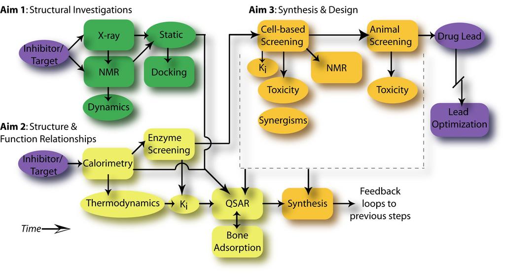
3 Talk Outline Chemoinformatics System Our Basic Requirements Registration / Results / Reports / Research Build vs. Buy Infrastructure / Cost / Maintenance / Development Results & Lessons Learned Short-term impact / long-term impact Future Directions New, advanced SAR modules

4 Our Laboratory


5 Our Basic Requirements Registration ~50 assays Results Reports Research Y= c + a b + c d +
6 A Decision Point Commercial Solution "Out of the box" functionality Restrictive Infrastructure Requirements Expensive, Perhaps Recurring Costs Completely Customizable? Programming Expertise Testing & Deployment Data Backup Custom Solution Decision to develop a custom solution that would meet, at first, our most basic requirements, with capability to expand at a later date.

7 Client-Server Architecture Multiple client platforms supported All code resides on the server Data all stored in one location

8 Specific Implementation Modular architecture allows new components to be quickly and easily added.
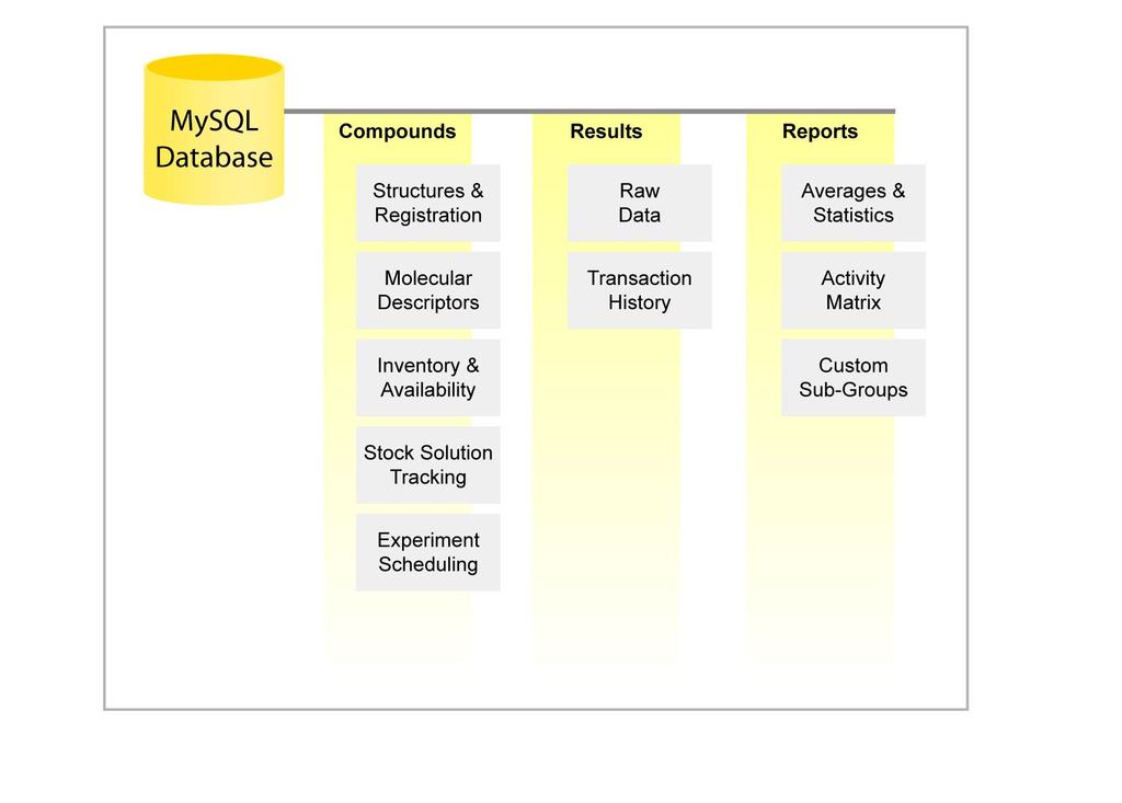
9 Database Architecture
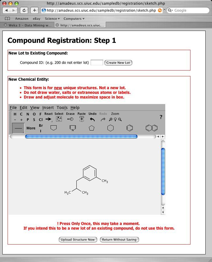
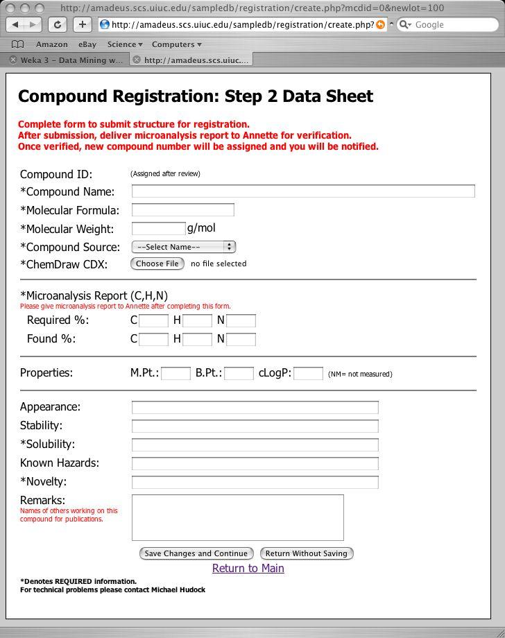
10 Compound Registration

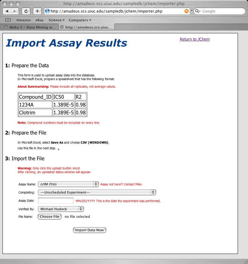
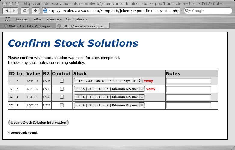
11 Input Results

12 Structures & Data United Using ChemAxon Marvin Java Applet

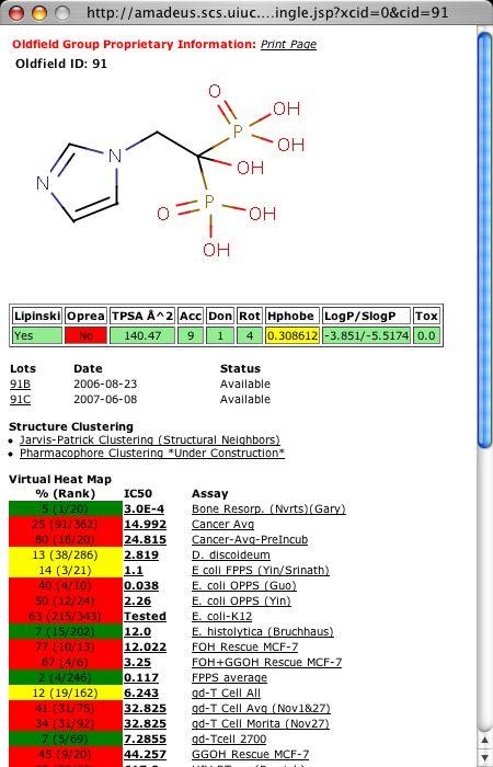
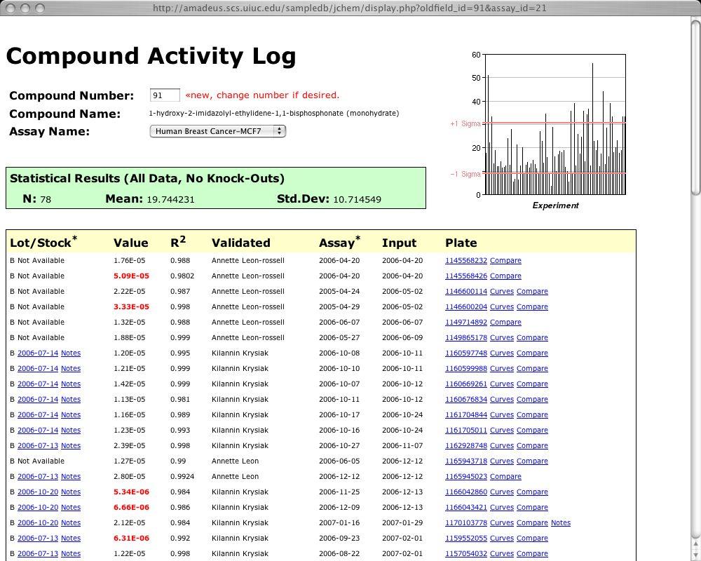

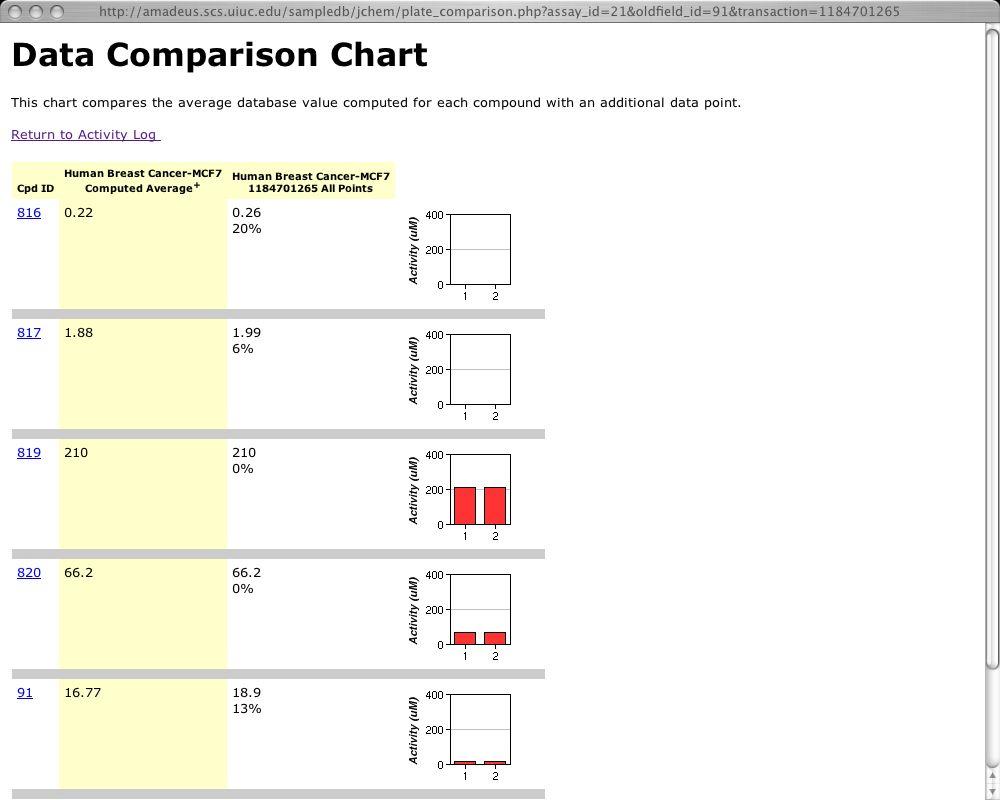
13 Retrieve Data Easily


14 Real-Time Data Analysis New analysis tools can be added quickly in response to user requests


15 Finding Patterns in a Few Clicks === Stratified cross-validation === === Summary === Correctly Classified Instances % Incorrectly Classified Instances % Kappa statistic Mean absolute error Root mean squared error Relative absolute error % Root relative squared error % Total Number of Instances 26 Provide SAR tools to all users, help detect trends. === Detailed Accuracy By Class === TP Rate FP Rate Precision Recall F-Measure Class cluster cluster2 === Confusion Matrix === a b <-- classified as 12 1 a = cluster b = cluster2


16 Additional Modules Easily Added Additional modules added over time as needed
17 Initial Impact Initial Development: 1 FTE, 1 month Updates & New Code: 1 FTE, 3 days/month Intuitive interface, short end user training Pre- Chemoinformatics Chemoinformatics What is the structure of compound 700? 20 sec. 20 min. Correlate assay A with assay B 5 sec. 30 min. for compounds 65% similar to cpd sec. 45 min. or instead, with assays B N 15 sec. 5 hours Will addition of CH 2 to 352 decrease activity? 10 sec. 25 min. Is assay A activity related to TPSA? 5 sec. 20 min. An informatics solution, commercial or custom, can have large positive impact on productivity - even for relatively small amounts of data.
18 Longer-Term Impact >1,000 unique compounds, >11,000 fittings Used daily by group members (~30) Data easily shared with entire group Trends now routinely identified publications Mindset: paper to electronic
19 How can I do this? Identify and implement basic requirements first, don t go overboard Programming typically requires functional understanding of databases and programming language such as PHP*. CS students, temporary help or computer savvy graduate students might be able help Use third-party components when appropriate, e.g. for plotting, displaying structures System can evolve over time, with sophisticated capabilities added with additional experience *Good Books: PHP and MySQL Web Development, Welling & Thompson, Web Database Applications with PHP & MySQL, Williams & Lane, 2004.

20 Acknowledgements CINF Division for the invitation to present National Institutes of Health Professor Eric Oldfield and members of the Oldfield Research Group, Department of Chemistry, University of Illinois at Urbana-Champaign Professor Eric Oldfield Yongcheng Song Yonghui Zhang Fenglin Yin Kilannin Krysiak Sujoy Mukherjee Dushyant Mukkamala Rong Cao Kyle Bergan
Integrated Cheminformatics to Guide Drug Discovery
 Integrated Cheminformatics to Guide Drug Discovery Matthew Segall, Ed Champness, Peter Hunt, Tamsin Mansley CINF Drug Discovery Cheminformatics Approaches August 23 rd 2017 Optibrium, StarDrop, Auto-Modeller,
No. of Days. Building 3D cities Using Esri City Engine ,859. Creating & Analyzing Surfaces Using ArcGIS Spatial Analyst 1 7 3,139
 Q3 What s New? Creating and Editing Data with ArcGIS Pro Editing and Maintaining Parcels Using ArcGIS Spatial Analysis Using ArcGIS Pro User Workflows for ArcGIS Online Organizations Q3-2018 ArcGIS Desktop
Why GIS & Why Internet GIS?
 Why GIS & Why Internet GIS? The Internet bandwagon Internet mapping (e.g., MapQuest) Location-based services Real-time navigation (e.g., traffic) Real-time service dispatch Business Intelligence Spatial
Lesson 6: Accuracy Assessment
 This work by the National Information Security and Geospatial Technologies Consortium (NISGTC), and except where otherwise Development was funded by the Department of Labor (DOL) Trade Adjustment Assistance
Reaxys Managing Complexity
 June 2009 Reaxys Managing Complexity Dr. Jürgen Swienty-Busch (j.swienty-busch@elsevier.com) What is Reaxys? Reaxys is Chemistry Covering more than 200 years of organic, organometallic and inorganic chemistry
DEKDIV: A Linked-Data-Driven Web Portal for Learning Analytics Data Enrichment, Interactive Visualization, and Knowledge Discovery
 DEKDIV: A Linked-Data-Driven Web Portal for Learning Analytics Data Enrichment, Interactive Visualization, and Knowledge Discovery Yingjie Hu, Grant McKenzie, Jiue-An Yang, Song Gao, Amin Abdalla, and
Supporting Information. Thermodynamics of Bisphosphonate Binding to Human Bone: A Two-Site Model
 Supporting Information Thermodynamics of Bisphosphonate Binding to Human Bone: A Two-Site Model Sujoy Mukherjee 1, Cancan Huang 1, Francisco Guerra 1, Ke Wang 2 and Eric Oldfield 1,2, * 1 Center for Biophysics
CARTOGRAPHY in a Web World
 CARTOGRAPHY in a Web World SENSE Research Cluster XIII meeting: Concepts and tools for spatial data visualization BAREND KÖBBEN kobben@itc.nl b.j.kobben@utwente.nl Agenda Short introduction to ITC and
Building innovative drug discovery alliances. Just in KNIME: Successful Process Driven Drug Discovery
 Building innovative drug discovery alliances Just in KIME: Successful Process Driven Drug Discovery Berlin KIME Spring Summit, Feb 2016 Research Informatics @ Evotec Evotec s worldwide operations 2 Pharmaceuticals
CHAPTER 22 GEOGRAPHIC INFORMATION SYSTEMS
 CHAPTER 22 GEOGRAPHIC INFORMATION SYSTEMS PURPOSE: This chapter establishes the administration and use of to improve the quality and accessibility of Department s spatial information and support graphical
CS4445 Data Mining and Knowledge Discovery in Databases. B Term 2014 Solutions Exam 2 - December 15, 2014
 CS4445 Data Mining and Knowledge Discovery in Databases. B Term 2014 Solutions Exam 2 - December 15, 2014 Prof. Carolina Ruiz Department of Computer Science Worcester Polytechnic Institute NAME: Prof.
Enabling ENVI. ArcGIS for Server
 Enabling ENVI throughh ArcGIS for Server 1 Imagery: A Unique and Valuable Source of Data Imagery is not just a base map, but a layer of rich information that can address problems faced by GIS users. >
Ákos Tarcsay CHEMAXON SOLUTIONS
 Ákos Tarcsay CHEMAXON SOLUTIONS FINDING NOVEL COMPOUNDS WITH IMPROVED OVERALL PROPERTY PROFILES Two faces of one world Structure Footprint Linked Data Reactions Analytical Batch Phys-Chem Assay Project
No. of Days. ArcGIS 3: Performing Analysis ,431. Building 3D cities Using Esri City Engine ,859
 What s New? Creating Story Maps with ArcGIS Field Data Collection and Management Using ArcGIS Get Started with Insights for ArcGIS Introduction to GIS Using ArcGIS & ArcGIS Pro: Essential Workflow Migrating
No. of Days. ArcGIS Pro for GIS Professionals ,431. Building 3D cities Using Esri City Engine ,859
 What s New? Creating Story Maps with ArcGIS Field Data Collection and Management Using ArcGIS Get Started with Insights for ArcGIS Introduction to GIS Using ArcGIS & ArcGIS Pro: Essential Workflow Migrating
Product Guide. Thermo Scientific Cellomics HCS Solution
 Product Guide Thermo Scientific Cellomics HCS Solution Thermo Scientific Cellomics HCS Solution Your Complete HCS Solution The search for new therapies for human diseases is increasingly driven by the
Large scale classification of chemical reactions from patent data
 Large scale classification of chemical reactions from patent data Gregory Landrum NIBR Informatics, Basel Novartis Institutes for BioMedical Research 10th International Conference on Chemical Structures/
WEB-BASED SPATIAL DECISION SUPPORT: TECHNICAL FOUNDATIONS AND APPLICATIONS
 WEB-BASED SPATIAL DECISION SUPPORT: TECHNICAL FOUNDATIONS AND APPLICATIONS Claus Rinner University of Muenster, Germany Piotr Jankowski San Diego State University, USA Keywords: geographic information
Management of Geological Information for Mining Sector Development and Investment Attraction Examples from Uganda and Tanzania
 Mineral Wealth Conference 2016 Kampala / Uganda Management of Geological Information for Mining Sector Development and Investment Attraction Examples from Uganda and Tanzania Andreas Barth 1, Andreas Knobloch
Introduction to Portal for ArcGIS. Hao LEE November 12, 2015
 Introduction to Portal for ArcGIS Hao LEE November 12, 2015 Agenda Web GIS pattern Product overview Installation and deployment Security and groups Configuration options Portal for ArcGIS + ArcGIS for
Web GIS Administration: Tips and Tricks
 EdUC 2017 July 8 th, 2017 Web GIS Administration: Tips and Tricks Geri Miller Agenda Concerns Acknowledged User Management Content Management Monitoring Licensing and logins Sophistication of IT support
JCICS Major Research Areas
 JCICS Major Research Areas Chemical Information Text Searching Structure and Substructure Searching Databases Patents George W.A. Milne C571 Lecture Fall 2002 1 JCICS Major Research Areas Chemical Computation
ArcGIS Enterprise: Administration Workflows STUDENT EDITION
 ArcGIS Enterprise: Administration Workflows STUDENT EDITION Copyright 2019 Esri All rights reserved. Course version 1.1. Version release date April 2019. Printed in the United States of America. The information
DRUG DISCOVERY TODAY ELN ELN. Chemistry. Biology. Known ligands. DBs. Generate chemistry ideas. Check chemical feasibility In-house.
 DRUG DISCOVERY TODAY Known ligands Chemistry ELN DBs Knowledge survey Therapeutic target Generate chemistry ideas Check chemical feasibility In-house Analyze SAR Synthesize or buy Report Test Journals
Introduction to Portal for ArcGIS
 Introduction to Portal for ArcGIS Derek Law Product Management March 10 th, 2015 Esri Developer Summit 2015 Agenda Web GIS pattern Product overview Installation and deployment Security and groups Configuration
Contents 1 Open-Source Tools, Techniques, and Data in Chemoinformatics
 Contents 1 Open-Source Tools, Techniques, and Data in Chemoinformatics... 1 1.1 Chemoinformatics... 2 1.1.1 Open-Source Tools... 2 1.1.2 Introduction to Programming Languages... 3 1.2 Chemical Structure
Geog 469 GIS Workshop. Managing Enterprise GIS Geodatabases
 Geog 469 GIS Workshop Managing Enterprise GIS Geodatabases Outline 1. Why is a geodatabase important for GIS? 2. What is the architecture of a geodatabase? 3. How can we compare and contrast three types
Esri and GIS Education
 Esri and GIS Education Organizations Esri Users 1,200 National Government Agencies 11,500 States & Regional Agencies 30,800 Cities & Local Governments 32,000 Businesses 8,500 Utilities 12,600 NGOs 11,000
A Model of GIS Interoperability Based on JavaRMI
 A Model of GIS Interoperability Based on Java Gao Gang-yi 1 Chen Hai-bo 2 1 Zhejiang University of Finance & Economics, Hangzhou 310018, China 2 College of Computer Science and Technology, Zhejiang UniversityHangzhou
Geo-enabling a Transactional Real Estate Management System A case study from the Minnesota Dept. of Transportation
 Geo-enabling a Transactional Real Estate Management System A case study from the Minnesota Dept. of Transportation Michael Terner Executive Vice President Co-author and Project Manager Andy Buck Overview
In Silico Investigation of Off-Target Effects
 PHARMA & LIFE SCIENCES WHITEPAPER In Silico Investigation of Off-Target Effects STREAMLINING IN SILICO PROFILING In silico techniques require exhaustive data and sophisticated, well-structured informatics
Performance Evaluation
 Performance Evaluation David S. Rosenberg Bloomberg ML EDU October 26, 2017 David S. Rosenberg (Bloomberg ML EDU) October 26, 2017 1 / 36 Baseline Models David S. Rosenberg (Bloomberg ML EDU) October 26,
Structure and Reaction querying in Reaxys
 Structure and Reaction querying in Reaxys A short history Dr. Jürgen Swienty-Busch, Derrick Umali April 5 2017 1 2 Agenda The History: where do we come from? The Present: Reaxys content today Indexing
Greater Portland Pulse: an Evolution
 Greater Portland Pulse: an Evolution Measuring and Monitoring Community Outcomes portlandpulse.org Meg Merrick, Ph. D. Institute of Portland Metropolitan Studies Portland State University merrickmpdx.edu
Available online at I-SEEC Proceeding - Science and Engineering (2013)
") Available online at www.iseec2012.com I-SEEC 2012 Proceeding - Science and Engineering (2013) 409 415 Proceeding Science and Engineering www.iseec2012.com Science and Engineering Symposium 4 th International
Available online at www.iseec2012.com I-SEEC 2012 Proceeding - Science and Engineering (2013) 409 415 Proceeding Science and Engineering www.iseec2012.com Science and Engineering Symposium 4 th International
Bentley Map Advancing GIS for the World s Infrastructure
 Bentley Map Advancing GIS for the World s Infrastructure Presentation Overview Why would you need Bentley Map? What is Bentley Map? Where is Bentley Map Used? Why would you need Bentley Map? Because your
A Service Architecture for Processing Big Earth Data in the Cloud with Geospatial Analytics and Machine Learning
 A Service Architecture for Processing Big Earth Data in the Cloud with Geospatial Analytics and Machine Learning WOLFGANG GLATZ & THOMAS BAHR 1 Abstract: The Geospatial Services Framework (GSF) brings
Paper UC1351. Conference: User Conference Date: 08/10/2006 Time: 8:30am-9:45am Room: Room 23-B (SDCC)
") Conference: User Conference Date: 08/10/2006 Time: 8:30am-9:45am Room: Room 23-B (SDCC) Title of Paper: Increasing the Use of GIS in the Federal Government Author Name: Miss Abstract This presentation
Conference: User Conference Date: 08/10/2006 Time: 8:30am-9:45am Room: Room 23-B (SDCC) Title of Paper: Increasing the Use of GIS in the Federal Government Author Name: Miss Abstract This presentation
Pharmaceutical e-learning at the University of Innsbruck
 Universität Innsbruck Pharmaceutical e-learning at the University of Innsbruck Dr. Daniela Schuster Institute of Pharmacy / Pharmaceutical Chemistry Outline How it all began: PharmXplorer Current applications
Land Board, NW Services and SDI Tambet Tiits, FRICS
 Land Board, NW Services and SDI Tambet Tiits, FRICS 07.09.2016 200th anniversary of the Struve Geodetic Arc Friedrich Georg Wilhelm Struve and Carl Friedrich Tenner Struve Geodetic Arc The Struve Geodetic
Develop a Spatial Information Management System: A Case Study for Faculty of Agriculture, University of Ruhuna, Sri Lanka
 Develop a Spatial Information Management System: A Case Study for Faculty of Agriculture, University of Ruhuna, Sri Lanka Prabath Priyankara 1*, Upul Indika 2 and Dimuthu Piyaratne 1 1 Computer Unit, Faculty
Web-based Interactive Landform Simulation Model (WILSIM)
") Web-based Interactive Landform Simulation Model (WILSIM) Wei Luo Dept. of Geography Northern Illinois University, DeKalb, IL 60115 Project Funded by NSF CCLI (2002-2004) Collaborators: Kirk Duffin, Jay
Web-based Interactive Landform Simulation Model (WILSIM) Wei Luo Dept. of Geography Northern Illinois University, DeKalb, IL 60115 Project Funded by NSF CCLI (2002-2004) Collaborators: Kirk Duffin, Jay
ARCHAVE : A Virtual Reality Interface for Archaeological 3D GIS. Master s Thesis Proposal by Daniel Acevedo Feliz
 ARCHAVE : A Virtual Reality Interface for Archaeological 3D GIS Master s Thesis Proposal by Daniel Acevedo Feliz Brown University February 4, 2000 Presentation Outline 1.- Motivation and definitions. Motivation
Inverse Functions. Say Thanks to the Authors Click (No sign in required)
") Inverse Functions Say Thanks to the Authors Click http://www.ck12.org/saythanks (No sign in required) To access a customizable version of this book, as well as other interactive content, visit www.ck12.org
Inverse Functions Say Thanks to the Authors Click http://www.ck12.org/saythanks (No sign in required) To access a customizable version of this book, as well as other interactive content, visit www.ck12.org
Marvin 5.4 A new generation of structure indexing at Elsevier. Dr. Michael Maier, Dr. Heike Nau, Elsevier
 Marvin 5.4 A new generation of structure indexing at Elsevier Dr. Michael Maier, Dr. Heike Nau, Elsevier Agenda Elsevier: Reaxys database Compound classes Structure requirements Marvin 5.4 Decision process
MetConsole AWOS. (Automated Weather Observation System) Make the most of your energy SM
 Make the most of your energy SM") MetConsole AWOS (Automated Weather Observation System) Meets your aviation weather needs with inherent flexibility, proven reliability Make the most of your energy SM Automated Weather Observation System
MetConsole AWOS (Automated Weather Observation System) Meets your aviation weather needs with inherent flexibility, proven reliability Make the most of your energy SM Automated Weather Observation System
SocViz: Visualization of Facebook Data
 SocViz: Visualization of Facebook Data Abhinav S Bhatele Department of Computer Science University of Illinois at Urbana Champaign Urbana, IL 61801 USA bhatele2@uiuc.edu Kyratso Karahalios Department of
GIS Geographical Information Systems. GIS Management
 GIS Geographical Information Systems GIS Management Difficulties on establishing a GIS Funding GIS Determining Project Standards Data Gathering Map Development Recruiting GIS Professionals Educating Staff
CSD. Unlock value from crystal structure information in the CSD
 CSD CSD-System Unlock value from crystal structure information in the CSD The Cambridge Structural Database (CSD) is the world s most comprehensive and up-todate knowledge base of crystal structure data,
PaikkaOppi - a Virtual Learning Environment on Geographic Information for Upper Secondary School
 PaikkaOppi - a Virtual Learning Environment on Geographic Information for Upper Secondary School Jaakko Kähkönen*, Lassi Lehto*, Juha Riihelä** * Finnish Geodetic Institute, PO Box 15, FI-02431 Masala,
Presentation of the Cooperation Project goals. Nicola Ferrè
 Presentation of the Cooperation Project goals Nicola Ferrè Project goals Capacity development for implementing a Geographic Information System (GIS) applied to surveillance, control and zoning of avian
Lesson 16: Technology Trends and Research
 http://www.esri.com/library/whitepapers/pdfs/integrated-geoenabled-soa.pdf GEOG DL582 : GIS Data Management Lesson 16: Technology Trends and Research Overview Learning Objective Questions: 1. Why is integration
Introduction to Chemoinformatics
 Introduction to Chemoinformatics Dr. Igor V. Tetko Helmholtz Zentrum München - German Research Center for Environmental Health (GmbH) Institute of Bioinformatics & Systems Biology (HMGU) Kyiv, 10 August
Programme Specification MSc in Cancer Chemistry
 Programme Specification MSc in Cancer Chemistry 1. COURSE AIMS AND STRUCTURE Background The MSc in Cancer Chemistry is based in the Department of Chemistry, University of Leicester. The MSc builds on the
Evaluating Physical, Chemical, and Biological Impacts from the Savannah Harbor Expansion Project Cooperative Agreement Number W912HZ
 Evaluating Physical, Chemical, and Biological Impacts from the Savannah Harbor Expansion Project Cooperative Agreement Number W912HZ-13-2-0013 Annual Report FY 2018 Submitted by Sergio Bernardes and Marguerite
for Effective Land Administration
 Role of Geospatial Technology in Land Information System(LIS) for Effective Land Administration Dr. Deb Jyoti Pal Sections Role of GIS in Land Records Proposed Work Flow Case Studies Role of GIS Creating
Portal for ArcGIS: An Introduction
 Portal for ArcGIS: An Introduction Derek Law Esri Product Management Esri UC 2014 Technical Workshop Agenda Web GIS pattern Product overview Installation and deployment Security and groups Configuration
Meridian Environmental Technology, Inc.
 Meridian Environmental Technology, Inc. Providing Tomorrow s Technology Today Meridian is committed to the support of its clients through advancement of science and technology A National Leader in Road
University of Illinois at Urbana-Champaign. Midterm Examination
 University of Illinois at Urbana-Champaign Midterm Examination CS410 Introduction to Text Information Systems Professor ChengXiang Zhai TA: Azadeh Shakery Time: 2:00 3:15pm, Mar. 14, 2007 Place: Room 1105,
4D information management system for road maintenance using GIS
 icccbe 2010 Nottingham University Press Proceedings of the International Conference on Computing in Civil and Building Engineering W Tizani (Editor) 4D information management system for road maintenance
History of the Atom. Say Thanks to the Authors Click (No sign in required)
") History of the Atom Say Thanks to the Authors Click http://www.ck12.org/saythanks (No sign in required) To access a customizable version of this book, as well as other interactive content, visit www.ck12.org
History of the Atom Say Thanks to the Authors Click http://www.ck12.org/saythanks (No sign in required) To access a customizable version of this book, as well as other interactive content, visit www.ck12.org
Spatial Data Availability Energizes Florida s Citizens
 NASCIO 2016 Recognition Awards Nomination Spatial Data Availability Energizes Florida s Citizens State of Florida Agency for State Technology & Department of Environmental Protection Category: ICT Innovations
CWMS Modeling for Real-Time Water Management
 Hydrologic Engineering Center Training Course on CWMS Modeling for Real-Time Water Management August 2018 Davis, California The Corps Water Management System (CWMS) is a software and hardware system to
The MDL Discovery Framework: Data and Application Integration in the Life Sciences
 MDL Information Systems Inc. San Leandro, California The MDL Discovery Framework: Data and Application Integration in the Life Sciences 2002 MDL Information Systems, Inc. All rights reserved. No part of
Errors, and What to Do. CS 188: Artificial Intelligence Fall What to Do About Errors. Later On. Some (Simplified) Biology
 Biology") CS 188: Artificial Intelligence Fall 2011 Lecture 22: Perceptrons and More! 11/15/2011 Dan Klein UC Berkeley Errors, and What to Do Examples of errors Dear GlobalSCAPE Customer, GlobalSCAPE has partnered
CS 188: Artificial Intelligence Fall 2011 Lecture 22: Perceptrons and More! 11/15/2011 Dan Klein UC Berkeley Errors, and What to Do Examples of errors Dear GlobalSCAPE Customer, GlobalSCAPE has partnered
CONCEPTS OF GENETICS BY ROBERT BROOKER DOWNLOAD EBOOK : CONCEPTS OF GENETICS BY ROBERT BROOKER PDF
 CONCEPTS OF GENETICS BY ROBERT BROOKER DOWNLOAD EBOOK : CONCEPTS OF GENETICS BY ROBERT BROOKER PDF Click link bellow and free register to download ebook: CONCEPTS OF GENETICS BY ROBERT BROOKER DOWNLOAD
Ministry of Health and Long-Term Care Geographic Information System (GIS) Strategy An Overview of the Strategy Implementation Plan November 2009
 Strategy An Overview of the Strategy Implementation Plan November 2009") Ministry of Health and Long-Term Care Geographic Information System (GIS) Strategy An Overview of the Strategy Implementation Plan November 2009 John Hill, Health Analytics Branch Health System Information
Ministry of Health and Long-Term Care Geographic Information System (GIS) Strategy An Overview of the Strategy Implementation Plan November 2009 John Hill, Health Analytics Branch Health System Information
CS 188: Artificial Intelligence Fall 2011
 CS 188: Artificial Intelligence Fall 2011 Lecture 22: Perceptrons and More! 11/15/2011 Dan Klein UC Berkeley Errors, and What to Do Examples of errors Dear GlobalSCAPE Customer, GlobalSCAPE has partnered
Kalexsyn Overview Kalexsyn, Inc Campus Drive Kalamazoo, MI Phone: (269) Fax: (269)
 Fax: (269)") Kalexsyn verview 2017 Kalexsyn, Inc. 4502 Campus Drive Kalamazoo, MI 49008 Phone: (269) 488-8488 Fax: (269) 488-8490 info@kalexsyn.com What we are Experienced medicinal chemists Conception and synthesis
Kalexsyn verview 2017 Kalexsyn, Inc. 4502 Campus Drive Kalamazoo, MI 49008 Phone: (269) 488-8488 Fax: (269) 488-8490 info@kalexsyn.com What we are Experienced medicinal chemists Conception and synthesis
Qualitative Spatio-Temporal Reasoning & Spatial Database Design
 Qualitative Spatio-Temporal Reasoning Focus on 2 research topics at the of the University of Liège J-P. Donnay P. Hallot F. Laplanche Curriculum in «Surveying & Geomatics» in the Faculty of Sciences of
GIS for Crime Analysis. Building Better Analysis Capabilities with the ArcGIS Platform
 GIS for Crime Analysis Building Better Analysis Capabilities with the ArcGIS Platform Crime Analysis The Current State One of the foundations of criminological theory is that three things are needed for
THIS IS NOT A PRESENTATION
 THIS IS NOT A PRESENTATION IT IS AN INVITATION Background Objectives Project Profile Distributed Geodata Management Current Status Remarks Gunnar Misund Associate Professor Head of Environmental Computing
Oregon Department of Transportation. Geographic Information Systems Strategic Plan
 Oregon Department of Transportation Geographic Information Systems Strategic Plan Adopted May, 2000 By the GIS Steering Committee Last printed 10/2/2012 4:20:00 PM Page Geographic Information Systems Strategic
Design and implementation of a new meteorology geographic information system
 Design and implementation of a new meteorology geographic information system WeiJiang Zheng, Bing. Luo, Zhengguang. Hu, Zhongliang. Lv National Meteorological Center, China Meteorological Administration,
Integration of ArcFM UT with SCADA, SAP, MAXIMO and Network Calculation
 Integration of ArcFM UT with SCADA, SAP, MAXIMO and Network Calculation Peter Harabin (VSE) Martin Mydliar (ArcGEO) July 9, 2013 Esri International User Conference Agenda > Business/process part = WHAT
MULTIVARIABLE CALCULUS BRIGGS PDF
 MULTIVARIABLE CALCULUS BRIGGS PDF ==> Download: MULTIVARIABLE CALCULUS BRIGGS PDF MULTIVARIABLE CALCULUS BRIGGS PDF - Are you searching for Multivariable Calculus Briggs Books? Now, you will be happy that
Free and Open Source Software for Cadastre and Land Registration : A Hidden Treasure? Gertrude Pieper Espada. Overview
 Free and Open Source Software for Cadastre and Land Registration : A Hidden Treasure? Gertrude Pieper Espada Overview FLOSS concepts Digital Land Administration systems FLOSS Database alternatives FLOSS
The Geodetic Infrastructure Management Via Web-Based Mapping Technology in Morocco
 The Geodetic Infrastructure Management Via Web-Based Mapping Technology in Morocco Moha EL-AYACHI, Khalid EL HAJARI, Said ALAOUI, and Omar JELLABI, Morocco Key words: infrastructure, web mapping, governance,
CARTOGRAPHY in a Web World
 CARTOGRAPHY in a Web World Nationale GI Minor BAREND KÖBBEN b.j.kobben@utwente.nl Agenda Short introduction to ITC and me Cartography: communicating spatial data Changing GIS & Cartography technology:
SPACE TIME ANALYSIS IN AN ENTERPRISE GIS Ritesh Agrawal, University of Illinois Urbana-Champaign
 SPACE TIME ANALYSIS IN AN ENTERPRISE GIS Ritesh Agrawal, University of Illinois Urbana-Champaign Email: ragrawal@uiuc.edu ABSTRACT: The spatial and non-spatial data is increasingly used in the disease
EasySDM: A Spatial Data Mining Platform
 EasySDM: A Spatial Data Mining Platform (User Manual) Authors: Amine Abdaoui and Mohamed Ala Al Chikha, Students at the National Computing Engineering School. Algiers. June 2013. 1. Overview EasySDM is
Metropolitan Wi-Fi Research Network at the Los Angeles State Historic Park
 Metropolitan Wi-Fi Research Network at the Los Angeles State Historic Park Vidyut Samanta vids@remap.ucla.edu Chase Laurelle Alexandria Knowles chase@remap.ucla.edu Jeff Burke jburke@remap.ucla.edu Fabian
Agenda. Status of GI activities. NGII Framework. SDI from the national policy perspective
 Towards a National Geographic Information Infrastructure: Overcoming Impediments to the Development of SDI in Nepal R.R. Chhatkuli Email: chhatkuli@ngiip.gov.np & D.M. Kayastha Email: chhatkuli@ngiip.gov.np
IMS4 ARWIS. Airport Runway Weather Information System. Real-time data, forecasts and early warnings
 Airport Runway Weather Information System Real-time data, forecasts and early warnings Airport Runway Weather Information System FEATURES: Detection and prediction of runway conditions Alarms on hazardous
Drug Informatics for Chemical Genomics...
 Drug Informatics for Chemical Genomics... An Overview First Annual ChemGen IGERT Retreat Sept 2005 Drug Informatics for Chemical Genomics... p. Topics ChemGen Informatics The ChemMine Project Library Comparison
Incorporating ArcGIS Pro in your Curriculum
 AAG, Boston 2017 April 5, 2017 Incorporating ArcGIS Pro in your Curriculum Geri Miller Agenda Concerns Acknowledged Learning curve ArcGIS Pro does not have all the tools (perception) Licensing and offline
Practical teaching of GIS at University of Liège
 Practical teaching of GIS at University of Liège Jean-Paul Kasprzyk, assistant Lessons Pr. Jean-Paul Donnay: For non-geographers (geologists, urban planners, engineers ) GIS users Master: Introduction
Test and Evaluation of an Electronic Database Selection Expert System
 282 Test and Evaluation of an Electronic Database Selection Expert System Introduction As the number of electronic bibliographic databases available continues to increase, library users are confronted
Performance Evaluation
 Performance Evaluation Confusion Matrix: Detected Positive Negative Actual Positive A: True Positive B: False Negative Negative C: False Positive D: True Negative Recall or Sensitivity or True Positive
Graduate Education in Institute of Chemistry, Chinese Academy of Sciences
 At 2014 IUPAC World Polymer Congress (MACRO 2014) July 6-11, Chiang Mai, Thailand Graduate Education in Institute of Chemistry, Chinese Academy of Sciences Jiasong He Institute of Chemistry, Chinese Academy
CADASTER & MC ITN ECO
 CADASTER & MC ITN ECO Igor V. Tetko Chemoinformatics group, IBIS, Helmholtz Zentrum München & eadmet GmbH (Germany) SPRING workshop, Beijing, July 2-3, 2011" Helmholtz Zentrum München Part of Helmholtz
POSITION DESCRIPTION. Position Title: Geographic Information Systems (GIS) Coordinator Department: Engineering
 Coordinator Department: Engineering") POSITION DESCRIPTION Position Title: Geographic Information Systems (GIS) Coordinator Department: Engineering Reports To: Engineering Supervisor FLSA Status: Exempt Date: April 2018 PRIMARY OBJECTIVE OF
POSITION DESCRIPTION Position Title: Geographic Information Systems (GIS) Coordinator Department: Engineering Reports To: Engineering Supervisor FLSA Status: Exempt Date: April 2018 PRIMARY OBJECTIVE OF
Solving Absolute Value Equations and Inequalities
 Solving Absolute Value Equations and Inequalities Say Thanks to the Authors Click http://www.ck1.org/saythanks (No sign in required) To access a customizable version of this book, as well as other interactive
Discovering The World Of Chemistry
 Discovering The World Of Chemistry Dr. Dimitrios Tzalis IMI Open Info Day: Horizon 2020 - Health, demographic change and wellbeing 18th September 2015 Brussel Taros Chemicals GmbH & Co. KG Taros: Stability,
Reaxys Medicinal Chemistry Fact Sheet
 R&D SOLUTIONS FOR PHARMA & LIFE SCIENCES Reaxys Medicinal Chemistry Fact Sheet Essential data for lead identification and optimization Reaxys Medicinal Chemistry empowers early discovery in drug development
An intelligent client application for on-line astronomical information
 An intelligent client application for on-line astronomical information Chenzhou CUI Chinese Virtual Observatory Project National Astronomical Observatory of China VO concept Virtual Observatory (VO) is
Real-time Geographic Information System (GIS) for Monitoring the Area of Potential Water Level Using Rule Based System
 for Monitoring the Area of Potential Water Level Using Rule Based System") Real-time Geographic Information System (GIS) for Monitoring the Area of Potential Water Level Using Rule Based System Wirdah Anugrah 1,*, Suryono Suryono 1, 2, and Jatmiko Endro Suseno 2 1 Magister of
Real-time Geographic Information System (GIS) for Monitoring the Area of Potential Water Level Using Rule Based System Wirdah Anugrah 1,*, Suryono Suryono 1, 2, and Jatmiko Endro Suseno 2 1 Magister of
DP Project Development Pvt. Ltd.
 Dear Sir/Madam, Greetings!!! Thanks for contacting DP Project Development for your training requirement. DP Project Development is leading professional training provider in GIS technologies and GIS application
Your Virtual Workforce. On Demand. Worldwide. COMPANY PRESENTATION. clickworker GmbH 2017
 Your Virtual Workforce. On Demand. Worldwide. COMPANY PRESENTATION 2017 CLICKWORKER AT A GLANCE Segment: Paid Crowdsourcing / Microtasking Services: Text Creation (incl. SEO Texts), AI-Training Data, Internet
Rapid Application Development using InforSense Open Workflow and Daylight Technologies Deliver Discovery Value
 Rapid Application Development using InforSense Open Workflow and Daylight Technologies Deliver Discovery Value Anthony Arvanites Daylight User Group Meeting March 10, 2005 Outline 1. Company Introduction