Macrophytes products
|
|
|
- Reynold Ross
- 6 years ago
- Views:
Transcription
1 Macrophytes products Paolo Villa, Monica Pinardi, Mariano Bresciani CNR-IREA
2
3 Introduction Aquatic vegetation, or macrophytes, fulfil a pivotal role in biogeochemical cycles. Synoptic capabilities of EO data make them a powerful tool for monitoring macrophyte characteristics and functionality Spectral and temporal features of different macrophytes used for producing maps of community type and bio-physical parameters
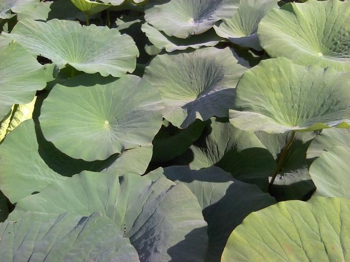
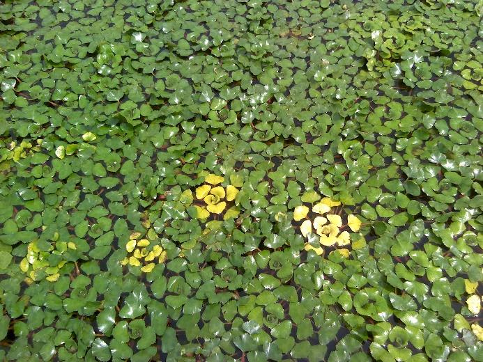
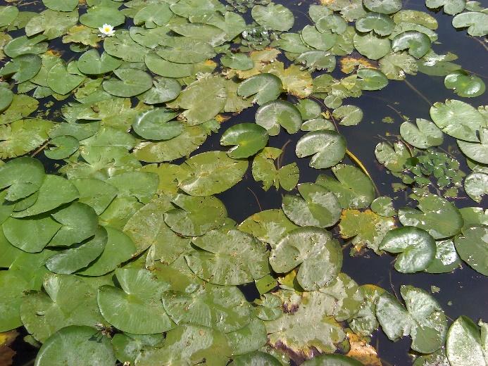
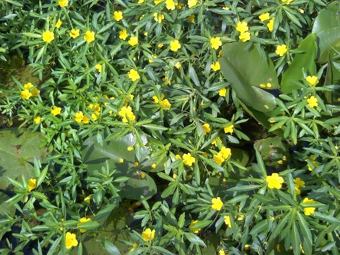
4 Target species Emergent helophytes P. australis (KB) P. australis (M) P. australis (M) T. angustifol. (KB) Helophytes: Phragmites australis, Typha angustifolia Emergent rhizophytes: Nelumbo nucifera Floating-leaved: Nymphaea alba, Nuphar lutea, Trapa natans, Ludwigia hexapetala, Free-floating: Spirodela polyrrhiza, Lemna minor, Salvinia natans, Azolla caroliniana Submerged: Ceratophyllum demersum, Myriophyllum spicatum, Najas marina marina, Vallisneria spiralis Emergent macrophytes Floating macrophytes Floating macrophytes i ti Submerged- Floating h t Submerged macrophytes N. nucifera (M) N. nucifera (M) N. nucifera (M) N. alba (KB) N. alba (M) N. lutea (M) N. lutea (M) P. natans (KB) T. natans (KB) T. natans (KB) T. natans (KB) N. alba + N. lutea (KB) C. demersum + N. lutea (KB) N. alba + N. lutea (KB) C. demersum + N. lutea (KB) C. demersum + T. natans (M) T. natans (M) C. demersum + L. minor (M) C. demersum (KB) N. marina (KB) N. marina (KB) U. vulgaris (KB) T. natans (M) C. demersum + L minor (M)
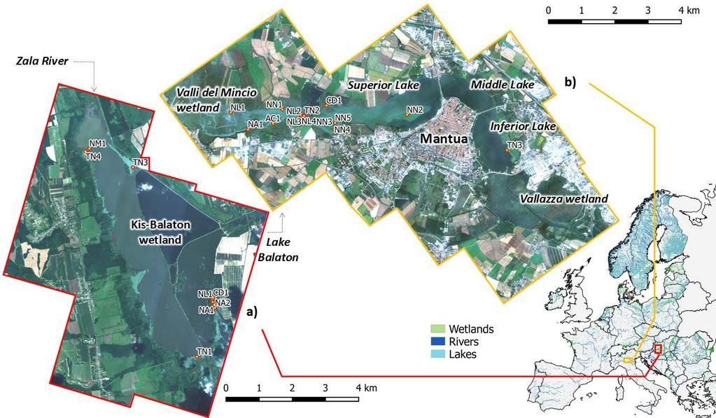
5 Community type mapping Classification approach EO data: Landsat TM, ETM+, OLI Case study: Mantua lakes, Kis Balaton wetland, Lake Trasimeno, Lake Taihu Input: Multi-temporal WAVI features Algo: Rule-based classification tree (C4.5) Output: 4 macrophyte community types (H, ER, FM, SF) + 2 classes (TV, OW) Validation: Overall Accuracy > 90% Error higher than 20% for Submerged-floating association Good, consistent performance (error < 20%) for all other groups/classes Tested over different area (Lake Varese) and with different spectral data (ALOS AVNIR-2) (Villa et al., 2015)
 Kis Balaton wetland")
 Lake Varese")
6 Lake Trasimeno (TM-ETM+, 2008) Lake Taihu (OLI-ETM+, 2013) Kis Balaton wetland (OLI-ETM+, 2014) Mantua lakes (OLI, 2014) Mantua lakes (AVNIR-2, 2010) Lake Varese (OLI, 2014)
7 Bio-physical parameters Target canopy bio-physical parameters (BPs): Fractional cover (fc) Leaf area index (LAI) Above-water biomass (kg dw m -2 ) EO data with different spectral resolution: Narrowband (APEX) Broadband (OLI, S5T5, Sentinel-2)
8
9 Macrophyte BPs mapping Estimation approach: Data: in situ canopy spectra, APEX data, multi-temporal S2A data (Mantua, Kis- Balaton) Algo: Semi-empirical regression modelling Input: Best performing spectral index for each BP and each EO dataset Output: maps of fc, LAI, AW biom Validation: High reliability for fc and LAI products (R 2 >0.6) Bias = -10%, MAPE = 13% for fc Bias = -0.19, MAPE = 19% for LAI Medium reliability for AW biom (R 2 = 0.35) Bias = kg dw m -2, MAPE = 34% (underestimation of high biomass) (Villa et al., 2017)


10 Kis-Balaton wetland (19 July 2014) Detail on Kányavár island area
11

 Mantua")
")
12 Mantua lakes, early growth (biomass) (22 May 2016) Mantua lakes growth peak (biomass) (28 July 2016)

13 (inter) Seasonal differences
14 (intra-) Seasonal dynamics Estimation approach: Data: in situ canopy spectra, 2015 yearly L8 - S5T5 - S2A data (Mantua, Grand Lieu), 2016 data for S2A (Mantua) Algo: Semi-empirical regression modelling for LAI estimation, TIMESAT for time series analysis Input: Best performing spectral index for S5T5 broadband data Output: Time series of macrophyte LAI, macrophyte phenology parameters (SoS, PoS, EoS, growth/senescence rate) Validation: High reliability for LAI time series (R 2 >0.8) Bias = -0.04, MAPE = 10% (underestimation of high density) (Villa et al., under review)
 (Villa et al.")
15 Mantua lakes - Phenology maps (2015 growing season) (Villa et al., under review)
 (Villa et al.")
16 Lac de Grand Lieu- Phenology maps (2015 growing season) (Villa et al., under review)
17 Conclusions New generation EO data can reliably provide spatial and temporal information about macrophytes, by mapping: community types bio-physical parameters seasonal dynamics (phenology) Scale of detail can vary between 5 m (airborne, VHR spaceborne) and m (operational spaceborne platforms) spatial grid resolution. Performance is lower for submerged vegetation (esp. in turbid systems) and for high density beds (tendency to underestimate fc and AW biom).

18 Thank you for your attention
Assessment of Macrophytes Seasonal Dynamics Using Dense Time Series of Satellite Data
 Assessment of Macrophytes Seasonal Dynamics Using Dense Time Series of Satellite Data Paolo Villa a, Mariano Bresciani a, Monica Pinardi a, Viktor R. Tóth b, Rossano Bolpagni c a Institute for Electromagnetic
Chlorophyll-a, Phycocyanin and Phytoplankton type products
 Chlorophyll-a, Phycocyanin and Phytoplankton type products Mariano Bresciani, Monica Pinardi, Claudia Giardino CNR IREA bresciani.m@irea.cnr.it Aims Implementation of algorithms dedicated to phytoplankton's
Crystal Lake Aquatic Plants. Dr. George Knoecklein
 Crystal Lake Aquatic Plants Dr. George Knoecklein Things to keep in mind 1. You will not learn it all in one season 2. Start a library of plant keys 3. Begin to get familiar with scientific names 1. In
2017 Aquatic Plant Survey: Silver Lake (WBIC# )
") Aquatic Plants in Silver Lake; Hennepin County, MN August 07 577 Creekside Lane Osseo, MN 5569 james@freshwatersci.com (65) 6-8696 07 Aquatic Plant Survey: Silver Lake (WBIC# 7-06-00) Surveyed August,
Aquatic Plants in Silver Lake; Hennepin County, MN August 07 577 Creekside Lane Osseo, MN 5569 james@freshwatersci.com (65) 6-8696 07 Aquatic Plant Survey: Silver Lake (WBIC# 7-06-00) Surveyed August,
Aquatic Plant Community of Crooked Lake: 2017 Anoka County, MN (# )
") Aquatic Plant Survey Crooked Lake (Anoka County, MN) August 07 577 Creekside Lane Osseo, MN 5569 james@freshwatersci.com (65) 6-8696 Aquatic Plant Community of Crooked Lake: 07 Anoka County, MN (#0-008)
Aquatic Plant Survey Crooked Lake (Anoka County, MN) August 07 577 Creekside Lane Osseo, MN 5569 james@freshwatersci.com (65) 6-8696 Aquatic Plant Community of Crooked Lake: 07 Anoka County, MN (#0-008)
Key to Non-native and invasive aquatic plants in Rhode Island (Adapted from C. Barre Hellquist, Massachusetts College of Liberal Arts)
") Key to Non-native and invasive aquatic plants in Rhode Island (Adapted from C. Barre Hellquist, Massachusetts College of Liberal Arts) 1. Leaves arising from base of plant in flowering plants 2. Flowers
Key to Non-native and invasive aquatic plants in Rhode Island (Adapted from C. Barre Hellquist, Massachusetts College of Liberal Arts) 1. Leaves arising from base of plant in flowering plants 2. Flowers
Journal of Research & Development, Vol. 17 (2017) ISSN
 ISSN") Diversity and Distribution of Macrophytic Vegetation in Dal Lake, Kashmir, India Heena Nisar 1, Saleem Farooq* 1, Suheel Ahmad 1, A. K. Pandit 2 and Baba Uqab 1 1 Department of Environmental Sciences,
Diversity and Distribution of Macrophytic Vegetation in Dal Lake, Kashmir, India Heena Nisar 1, Saleem Farooq* 1, Suheel Ahmad 1, A. K. Pandit 2 and Baba Uqab 1 1 Department of Environmental Sciences,
Table 1: 2012 Aquatic Plant Community Statistics, Fish Lake, Dane County, WI Aquatic Plant Community Statistics 2012
 APPENDIX A FISH LAKE PLANT STATISTICS (2012) Table 1: 2012 Aquatic Plant Community Statistics, Fish Lake, Dane County, WI Aquatic Plant Community Statistics 2012 Number of sites sampled 474 Number of sites
Other Ingredients: % Total: %
 Supplemental Label Aquatic Weeds Controlled This supplemental label expires December 31, 2014, and must not be used or distributed after this date. Active Ingredient: ammonium salt of imazamox: 2-[4,5-dihydro-4-methyl-4-(1-methylethyl)-5-oxo-1Himidazol-2-yl]-5-(methoxymethyl)-3-pyridinecarboxylic
Horticulturist Award Program
 Horticulturist Award Program Purpose : The Aquatic Horticulture Award Program (HAP) has been established to recognize and encourage outstanding achievement in the maintenance and propagation of aquatic
Field Guide. To The Aquatic Plants of. Cobbett s Pond. May Improvement Association. Prepared for: Prepared by:
 To The Aquatic Plants of Cobbett s Pond May 2010 Prepared for: Cobbett s Pond Improvement Association Prepared by: 289 Great Rd., Acton, MA 01720 (978) 263-9588 This to the Aquatic Plants of Cobbett s
This supplemental label expires December 31, 2014, and must not be used or distributed after this date.
 Supplemental Label Clearcast HERBICIDE EPA Reg. No. 241-437-67690 This supplemental label expires December 31, 2014, and must not be used or distributed after this date. Active Ingredient: ammonium salt
Efficacy of Herbicide Active Ingredients Against Aquatic Weeds 1
 SS-AGR-44 Efficacy of Herbicide Active Ingredients Against Aquatic Weeds 1 S. F. Enloe, M. D. Netherland, W. Haller, and K. Langeland 2 Weed control is often a critical component of aquatic vegetation
PINE LAKE AQUATIC PLANT SURVEY PINE LAKE, HILES WISCONSIN DECEMBER 2016 PO BOX 273 PARK FALLS, WI
 PINE LAKE AQUATIC PLANT SURVEY PINE LAKE, HILES WISCONSIN DECEMBER 2016 PO BOX 273 PARK FALLS, WI 54552 715.965.3489 TIFFINEY@FLAMBEAUENGINEERING.COM PINE LAKE AQUATIC PLANT SURVEY An aquatic plant survey
GLOBWETLAND AFRICA TOOLBOX
 The GlobWetland Africa Toolbox is an open source and free-of-charge software toolbox for inventorying, mapping, monitoring and assessing wetlands. The toolbox comes with end-to-end processing workflows
Lake Vermilion ( ) Aquatic Vegetation Survey
 Aquatic Vegetation Survey") Lake Vermilion (69-0378 - 00) Aquatic Vegetation Survey 22796 County Highway 6 Detroit Lakes, MN 56501 (218) 846-1465 www.rmbel.info Table of Contents Executive Summary... 3 Introduction... 4 Methods...
Lake Vermilion (69-0378 - 00) Aquatic Vegetation Survey 22796 County Highway 6 Detroit Lakes, MN 56501 (218) 846-1465 www.rmbel.info Table of Contents Executive Summary... 3 Introduction... 4 Methods...
CONTRIBUTIONS TO AQUATIC VEGETATION OF ISAC-UZLINA COMPLEX KNOWLEDGE
 Buletinul Grădinii Botanice Iaşi Tomul 12, 2004 35 CONTRIBUTIONS TO AQUATIC VEGETATION OF ISAC-UZLINA COMPLEX KNOWLEDGE N. ŞTEFAN, C. MARDARI Abstract: Aquatic vegetation represents an important natural
Many of remote sensing techniques are generic in nature and may be applied to a variety of vegetated landscapes, including
 Remote Sensing of Vegetation Many of remote sensing techniques are generic in nature and may be applied to a variety of vegetated landscapes, including 1. Agriculture 2. Forest 3. Rangeland 4. Wetland,
The role of macrophytes in Ladoga Lake ecosystems
 Russian State Hydrometeorological University Department of Applied Ecology The role of macrophytes in Ladoga Lake ecosystems Dr. Nadezhda Zuyeva Valaam 2010 One of the most important components of the
Habitat mapping project of the proposed Iraqi Marshlands National Park area
 BioRisk 3: 55 68 (2009) doi: 10.3897/biorisk.3.19 Habitat mapping project of the proposed Iraqi Marshlands National Park area 55 www.pensoftonline.net/biorisk RESEARCH ARTICLE A peer-reviewed open-access
URBAN MAPPING AND CHANGE DETECTION
 URBAN MAPPING AND CHANGE DETECTION Sebastian van der Linden with contributions from Akpona Okujeni Humboldt-Unveristät zu Berlin, Germany Introduction Introduction The urban millennium Source: United Nations,
SLELO PRISM s Invasive Species Volunteer Surveillance Network Guide for Aquatic Plants
 SLELO PRISM s Invasive Species Volunteer Surveillance Network Guide for Aquatic Plants 2018 ST. LAWRENCE EASTERN LAKE ONTARIO PARTNERSHIP FOR REGIONAL INVASIVE SPECIES MANAGEMENT To learn more visit www.sleloinvasvies.org
Capabilities and Limitations of Land Cover and Satellite Data for Biomass Estimation in African Ecosystems Valerio Avitabile
 Capabilities and Limitations of Land Cover and Satellite Data for Biomass Estimation in African Ecosystems Valerio Avitabile Kaniyo Pabidi - Budongo Forest Reserve November 13th, 2008 Outline of the presentation
Ross Barnett Backwater Restoration: 2012 Pilot Project
 River Bend reference site during the 2012 backwater restoration pilot study A Report to the Pearl River Valley Water Supply District Bradley T. Sartain and John D. Madsen Mississippi State University Geosystems
Big Red Fish / Walton
 Aquatic plant data collected on July 26, 2000 Big Red Fish / Walton Percent area covered with aquatic vegetation (PAC, %). Percent of lake's volume filled with vegetation (PVI, %). Average emergent plant
Greening of Arctic: Knowledge and Uncertainties
 Greening of Arctic: Knowledge and Uncertainties Jiong Jia, Hesong Wang Chinese Academy of Science jiong@tea.ac.cn Howie Epstein Skip Walker Moscow, January 28, 2008 Global Warming and Its Impact IMPACTS
Structure & Functions
 ESP 155 - WETLAND ECOLOGY, Fall 2004 1 HANDOUT No. 4 (For 10/18 & 10/20 2004): WETLAND & AQUATIC PLANTS Structure & Functions Not in M&G; Teaching Resources computer unit on plants Aquatic Macrophytes
WETLAND & AQUATIC PLANTS Structure & Functions
 WETLAND & AQUATIC PLANTS Structure & Functions for there are some plants which cannot live except in wet; and again these are distinguished from one another by their fondness for different kind of wetness;
Aquatic Plants of Eastman Pond, Eastman
 Aquatic Plants of Eastman Pond, Eastman State Contact: Amy P. Smagula Limnologist/Exotic Aquatic Plant Program Coordinator 603-271 271-22482248 or asmagula@des.state.nh.us Current status of exotic plant
THE PLANT COMMUNITIES OF CLASSES HYDROCHARI-LEMNETEA OBERD AND POTAMETEA TX. ET PRSG OF THE LABUDOVO OKNO LOCALITY (SERBIA)
") Zbornik Matice srpske za prirodne nauke / Proc. Nat. Sci, Matica Srpska Novi Sad, 115, 101 107, 2008 UDC 908(497.1) DOI:10.2298/ZMSPN0815101P Dubravka M. Poliã 1, Ru ÿica S. Ig iã 1, Slobodanka J. Stojanoviã
Zbornik Matice srpske za prirodne nauke / Proc. Nat. Sci, Matica Srpska Novi Sad, 115, 101 107, 2008 UDC 908(497.1) DOI:10.2298/ZMSPN0815101P Dubravka M. Poliã 1, Ru ÿica S. Ig iã 1, Slobodanka J. Stojanoviã
Aquatic Plants of MESSER POND
 Aquatic Plants of MESSER POND State Contact: Amy P. Smagula Limnologist/Exotic Aquatic Plant Program Coordinator 603-271-2248 or Amy.Smagula@des.nh.gov Overview This slideshow includes four sections aimed
Remote Sensing Based Inversion of Gap Fraction for Determination of Leaf Area Index. Alemu Gonsamo 1 and Petri Pellikka 1
 Remote Sensing Based Inversion of Gap Fraction for Determination of Leaf Area Index Alemu Gonsamo and Petri Pellikka Department of Geography, University of Helsinki, P.O. Box, FIN- Helsinki, Finland; +-()--;
Interannual variation of MODIS NDVI in Lake Taihu and its relation to climate in submerged macrophyte region
 Yale-NUIST Center on Atmospheric Environment Interannual variation of MODIS NDVI in Lake Taihu and its relation to climate in submerged macrophyte region ZhangZhen 2015.07.10 1 Outline Introduction Data
Evaluation of estimated satellite images for filling data gaps in an intra-annual high spatial resolution time-series
 Evaluation of estimated satellite images for filling data gaps in an intra-annual high spatial resolution time-series Tobias Schmidt, Michael Förster, Birgit Kleinschmit Technical University Berlin, Geoinformation
The Invasive Status of Giant Salvinia and Hydrilla in Mississippi
 Wilfredo Robles, John D. Madsen, Victor L. Maddox and Ryan M. Wersal GeoResources Institute Mississippi State University Box 9952 Starkville, MS 39762 662-325-2311 E-mail: wr40@pss.msstate.edu ABSTRACT
Aquatic Plant Community in Rice Lake: 2014 Hennepin County, MN (# )
") www.fixmylake.com 809 8 rd Avenue orth Maple Grove, M 55 mail@freshwatersci.com (65) 6-8696 Aquatic Plant Community in Rice Lake: 0 Hennepin County, M (#7-06) Surveyed July 5, 0 Surveying, Analysis, and
www.fixmylake.com 809 8 rd Avenue orth Maple Grove, M 55 mail@freshwatersci.com (65) 6-8696 Aquatic Plant Community in Rice Lake: 0 Hennepin County, M (#7-06) Surveyed July 5, 0 Surveying, Analysis, and
Effects of interannual climate variability on tropical tree cover
 Effects of interannual climate variability on tropical tree cover Milena Holmgren, Marina Hirota, Egbert H. Van Nes & Marten Scheffer Correspondence to: milena.holmgren@wur.nl Contents: 1. Climate Indexes.
Hydrophytes of Pond Near Chiyada Village, Bavla, Gujarat - India
 International Journal of Allied Practice, Research and Review Website: www.ijaprr.com (ISSN 2350-1294) Hydrophytes of Pond Near Chiyada Village, Bavla, Gujarat - India Bharat B. Maitreya Botany Department,
Appendix B. The Importance of Aquatic Plants
 Appendix B The Importance of Aquatic Plants The Importance of Aquatic Plants Plant information was gathered from Borman et al. (1997), Eggers and Reed (1997), Fink (1994), Nichols and Vennie (1991), and
This module presents remotely sensed assessment (choice of sensors and resolutions; airborne or ground based sensors; ground truthing)
") This module presents remotely sensed assessment (choice of sensors and resolutions; airborne or ground based sensors; ground truthing) 1 In this presentation you will be introduced to approaches for using
This module presents remotely sensed assessment (choice of sensors and resolutions; airborne or ground based sensors; ground truthing) 1 In this presentation you will be introduced to approaches for using
Eric Mougin & Josiane Seghieri CESBIO. TT members : 20 european teams 6 malian institutions
 TT3 EOP integrative studies on the Gourma meso-scale site (Mali) Eric Mougin & Josiane Seghieri CESBIO TT members : 20 european teams 6 malian institutions The AMMA meso-scale sites Gourma Niamey Ouémé
Biology and the hierarchies of life. finer scale. coarser scale. individual. populations. metapopulation. community. ecosystem. biome.
 Biology and the hierarchies of life finer scale individual populations metapopulation community ecosystem biome coarser scale biosphere 1 Communities: all species that live together in one place Eucalypt
Aquatic Plant Survey Methods
 Aquatic Plant Survey Methods Field Methods Harmony Environmental employed a point intercept method for the macrophyte sampling. The Wisconsin Department of Natural Resources (Wisconsin DNR) generated the
Urban Mapping & Change Detection. Sebastian van der Linden Humboldt-Universität zu Berlin, Germany
 Urban Mapping & Change Detection Sebastian van der Linden Humboldt-Universität zu Berlin, Germany Introduction - The urban millennium Source: United Nations Introduction Text Source: Google Earth Introduction
Effects of different macrophyte growth forms on sediment and P resuspension in a shallow lake
 Hydrobiologia (25) 545:167 175 Ó Springer 25 DOI 1.17/s175-5-2677-9 Primary Research Paper Effects of different macrophyte growth forms on sediment and P resuspension in a shallow lake Jukka Horppila*,
Aquatic Plants of Canaan Street Lake, Canaan
 Aquatic Plants of Canaan Street Lake, Canaan State Contact: Amy P. Smagula Limnologist/Exotic Aquatic Plant Program Coordinator 603-271-2248 or Amy.Smagula@des.nh.gov Current status of exotic plant infestations
The Wide Dynamic Range Vegetation Index and its Potential Utility for Gap Analysis
 Summary StatMod provides an easy-to-use and inexpensive tool for spatially applying the classification rules generated from the CT algorithm in S-PLUS. While the focus of this article was to use StatMod
Invasive Species Pilot Project: Site Visit Report
 Invasive Species Pilot Project: Site Visit Report Waterbody: Trout Lake Visit Date: August 16 th, 2018 Preamble: The Federation of Ontario Cottagers Associations (FOCA) is a non-profit, voluntary organization
Ryan Baum, MS Candidate, ISU Matthew Germino, Assistant Professor, ISU
 Spatial and temporal variation in remotely sensed vegetation indices on the INEEL from 1984-2002 Ryan Baum, MS Candidate, ISU Matthew Germino, Assistant Professor, ISU Importance How does vegetation vary
Department of Biological Sciences, Murray State University, Murray, Kentucky 42071, USA
 1 Department of Biological Sciences, Murray State University, Murray, Kentucky 42071, USA 2 Fondazione Edmund Mach, Research and Innovation Center, Department of Biodiversity and Molecular Ecology, GIS
Remote detection of giant reed invasions in riparian habitats: challenges and opportunities for management planning
 Remote detection of giant reed invasions in riparian habitats: challenges and opportunities for management planning Maria do Rosário Pereira Fernandes Forest Research Centre, University of Lisbon Number
Aquatic Plant Community of the Red Cedar Lakes
 2011, Freshwater Scientific Services, LLC Page 1 of 69. Aquatic Plant Community of the Red Cedar Lakes, July/Aug 2011 www.fixmylake.com 18029 83 rd Avenue North Maple Grove, MN 55311 mail@freshwatersci.com
Urban Mapping. Sebastian van der Linden, Akpona Okujeni, Franz Schug 11/09/2018
 Urban Mapping Sebastian van der Linden, Akpona Okujeni, Franz Schug 11/09/2018 Introduction to urban remote sensing Introduction The urban millennium Source: United Nations, 2014 Urban areas mark extremes
Management of Flowering Rush Using the Contact Herbicide Diquat in Detroit Lakes, Minnesota 2014
 Management of Flowering Rush Using the Contact Herbicide Diquat in Detroit Lakes, Minnesota 2014 A report to the Pelican River Watershed District Gray Turnage 1 and John D. Madsen 2 1 Geosystems Research
Characterizing Urbanization Processes in West Africa using Multi-temporal Earth Observation Data
 Characterizing Urbanization Processes in West Africa using Multi-temporal Earth Observation Data Sebastian van der Linden 1,2 Franz Schug 2 Akpona Okujen 2 Patrick Hostert 1,2 Jonas Ø. Nielsen 1,2 Janine
Copernicus Global Land Service
 Copernicus Global Land Service Cryosphere Products Kari Luojus on behalf the consortium Follow us on: Copernicus EU CopernicusEU www.copernicus.eu Copernicus Services Land Marine Atmosphere Emergency Security
Lecture Topics. 1. Vegetation Indices 2. Global NDVI data sets 3. Analysis of temporal NDVI trends
 Lecture Topics 1. Vegetation Indices 2. Global NDVI data sets 3. Analysis of temporal NDVI trends Why use NDVI? Normalize external effects of sun angle, viewing angle, and atmospheric effects Normalize
ESM 186 Environmental Remote Sensing and ESM 186 Lab Syllabus Winter 2012
 ESM 186 Environmental Remote Sensing and ESM 186 Lab Syllabus Winter 2012 Instructor: Susan Ustin (slustin@ucdavis.edu) Phone: 752-0621 Office: 233 Veihmeyer Hall and 115A, the Barn Office Hours: Tuesday
Sentinel 2 Pre-processing Requirements for coastal and inland waters
 Sentinel 2 Pre-processing Requirements for coastal and inland waters K A I S Ø R E NSEN NIVA CARSTEN B R O CKMANN Ecological and chemical classification of water bodies in Norway Water quality - products
Interpolation of daily mean air temperature data via spatial and non-spatial copulas
 Interpolation of daily mean air temperature data via spatial and non-spatial copulas F. Alidoost, A. Stein f.alidoost@utwente.nl 6 July 2017 Research problem 2 Assessing near-real time crop and irrigation
Spatial variations of CH 4 in surface air over Lake Taihu. Zhang Mi, Wang Shumin, Xu Jingzheng, Hu Cheng, Xiao Qitao
 Spatial variations of CH 4 in surface air over Lake Taihu Zhang Mi, Wang Shumin, Xu Jingzheng, Hu Cheng, Xiao Qitao 2014. 07. 18 Outline Introduction Objective Measurements Results Work plan 1. Introduction
Hydrophytes of selected wetlands of Tirunelveli district Tamil Nadu, India
 International Journal of Fisheries and Aquatic Research ISSN: 2456-7248 Impact Factor: RJIF 5.44 www.fishjournals.com Volume 3; Issue 4; October 2018; Page No. 45-49 Hydrophytes of selected wetlands of
Field Guide to Aquatic Plants of Alabama
 Field Guide to Aquatic Plants of Alabama Prepared by the Alabama Department of Conservation and Natural Resources Fisheries Section 1 Field Guide to Aquatic Plants of Alabama R. Graves Lovell Alabama Department
Mapping of Freshwater Lake Wetlands Using Object-Relations and Rule-based Inference
 Chin. Geogra. Sci. 2012 Vol. 22 No. 4 pp. 462 471 doi: 10.1007/s11769-012-0521-5 www.springerlink.com/content/1002-0063 Mapping of Freshwater Lake Wetlands Using Object-Relations and Rule-based Inference
GNR401 Principles of Satellite Image Processing
 Principles of Satellite Image Processing Instructor: Prof. CSRE, IIT Bombay bkmohan@csre.iitb.ac.in Slot 5 Guest Lecture PCT and Band Arithmetic November 07, 2012 9.30 AM 10.55 AM IIT Bombay Slide 1 November
Urban remote sensing: from local to global and back
 Urban remote sensing: from local to global and back Paolo Gamba University of Pavia, Italy A few words about Pavia Historical University (1361) in a nice town slide 3 Geoscience and Remote Sensing Society
SATellite MOnitoring of VEgetation Seasonality SAT-MOVES. Brian O Connor, Ned Dwyer, Fiona Cawkwell
 SATellite MOnitoring of VEgetation Seasonality SAT-MOVES Brian O Connor, Ned Dwyer, Fiona Cawkwell Objective: To investigate a methodology for the potential of earth observation satellites to monitor vegetation
Cross-Sensor Continuity Science Algorithm
 Cross-Sensor Continuity Science Algorithm - Long Term Vegetation Index and Phenology Workshop - Javzan Tsend-Ayush and Tomoaki Miura Department of Natural Resources and Environmental Management University
Weather and climate outlooks for crop estimates
 Weather and climate outlooks for crop estimates CELC meeting 2016-04-21 ARC ISCW Observed weather data Modeled weather data Short-range forecasts Seasonal forecasts Climate change scenario data Introduction
REVIEW OF AQUATIC VEGETATION OF THE REGIONAL PARK "STARI BEGEJ"
 TISCIA 29, 27-32 REVIEW OF AQUATIC VEGETATION OF THE REGIONAL PARK "STARI BEGEJ" B. Butorac Butorac, B. (1995): Review of aquatic vegetation of the regional park "Stari Begej". - Tiscia 29, 27-32. Abstract.
Aquatic invertebrate herbivores in association with Myriophyllum spicatum in Otsego Lake, summer 1999
 80 Aquatic invertebrate herbivores in association with Myriophyllum spicatum in Otsego Lake, summer 1999 Robert L. Johnson, Jason A. Toner, Alison C. C. Colbyl NTRODUCTON Two invertebrate herbivores, a
CadasterENV Sweden Time series in support of a multi-purpose land cover mapping system at national scale
 CadasterENV Sweden Time series in support of a multi-purpose land cover mapping system at national scale Mats Rosengren, Camilla Jönsson ; Metria AB Marc Paganini ; ESA ESRIN Background CadasterENV Sweden
Feb 6 Primary Productivity: Controls, Patterns, Consequences. Yucatan, Mexico, Dry Subtropical
 Feb 6 Primary Productivity: Controls, Patterns, Consequences Yucatan, Mexico, Dry Subtropical History Hutchinson (1959), What factors limit the number of species in a place? - habitat heterogeneity - habitat
Atmosphere and Ocean Research Institute, The
 Mapping seagrass and seaweed beds in NOWPAP Teruhisa Komatsu Atmosphere and Ocean Research Institute, The University of Tokyo Contents What is coastal habitat? Important ecological roles of coastal habitats
DIVERSITY, DISTRIBUTION AND ECOLOGY OF THE FRESHWATER NATURAL HABITATS FROM SOUTHERN OF OLTENIA, ROMANIA
 Scientific Papers. Series A. Agronomy, Vol. LIX, 2016 ISSN 2285-5785; ISSN CD-ROM 2285-5793; ISSN Online 2285-5807; ISSN-L 2285-5785 DIVERSITY, DISTRIBUTION AND ECOLOGY OF THE FRESHWATER NATURAL HABITATS
Supporting Information for: Effects of payments for ecosystem services on wildlife habitat recovery
 Supporting Information for: Effects of payments for ecosystem services on wildlife habitat recovery Appendix S1. Spatiotemporal dynamics of panda habitat To estimate panda habitat suitability across the
Challenges for the operational assimilation of satellite image data in agrometeorological models
 Challenges for the operational assimilation of satellite image data in agrometeorological models Mark Danson Centre for Environmental Systems Research, University of Salford, UK 0 Objectives The main objective
Fundamental Interactions with Earth Surface
 Fundamental Interactions with Earth Surface 1 / 96 http://speclab.cr.usgs.gov/papers/tetracorder/ GEO 827 - Digital Image Processing and Analysis 2 / 96 http://www.markelowitz.com/hyperspectral.html 3
ESTABLISHMENT AND COMPETITIVE ABILITY OF NELUMBO LUTEA IN RELATION TO MYRIOPHYLLUM SPICATUM. Joe R. Snow, B.A. Thesis Prepared for the Degree of
 ESTABLISHMENT AND COMPETITIVE ABILITY OF NELUMBO LUTEA IN RELATION TO MYRIOPHYLLUM SPICATUM Joe R. Snow, B.A. Thesis Prepared for the Degree of MASTER OF SCIENCE UNIVERSITY OF NORTH TEXAS December 2000
Patterns of impact of three invasive plant species on freshwater ecosystems
 Patterns of impact of three invasive plant species on freshwater ecosystems Iris Stiers & Ludwig Triest Vrije Universiteit Brussel, Plant Biology and Nature Management, BELGIUM freshwater ecosystem WITHOUT
Application and impacts of the GlobeLand30 land cover dataset on the Beijing Climate Center Climate Model
 IOP Conference Series: Earth and Environmental Science PAPER OPEN ACCESS Application and impacts of the GlobeLand30 land cover dataset on the Beijing Climate Center Climate Model To cite this article:
Characterization of Coastal Wetland Systems using Multiple Remote Sensing Data Types and Analytical Techniques
 Characterization of Coastal Wetland Systems using Multiple Remote Sensing Data Types and Analytical Techniques Daniel Civco, James Hurd, and Sandy Prisloe Center for Land use Education and Research University
GEOGG141 Principles & Practice of Remote Sensing (PPRS) RADAR III: Applications Revision
 RADAR III: Applications Revision") UCL DEPARTMENT OF GEOGRAPHY GEOGG141 Principles & Practice of Remote Sensing (PPRS) RADAR III: Applications Revision Dr. Mathias (Mat) Disney UCL Geography Office: 113, Pearson Building Tel: 7670 0592
UCL DEPARTMENT OF GEOGRAPHY GEOGG141 Principles & Practice of Remote Sensing (PPRS) RADAR III: Applications Revision Dr. Mathias (Mat) Disney UCL Geography Office: 113, Pearson Building Tel: 7670 0592
EVALUATION REPORT ON INTEGRATION OF RS DATA
 Crop Monitoring as an E agricultural tool in Developing Countries EVALUATION REPORT ON INTEGRATION OF RS DATA Reference: Author(s): Simone Bregaglio, Valentina Pagani, Giacinto Manfron, Mirco Boschetti,
A Community Member s Guide to Aquatic Plants. Emelia Hauck Jacobs Field Lead Plant Taxonomist RMB Environmental Laboratories, Inc.
 A Community Member s Guide to Aquatic Plants Emelia Hauck Jacobs Field Lead Plant Taxonomist RMB Environmental Laboratories, Inc. Agenda Importance of aquatic plants How to identify common native aquatic
GCOS High Resolution Land Cover ECV. Slide 11
 GCOS High Resolution Land Cover ECV Slide 11 Detailed Land Cover and Climate Land cover and its changes modify the goods and services provided to human society force climate by altering water and energy
Land Surface Remote Sensing II
 PROCEEDINGS OFSPIE Land Surface Remote Sensing II Thomas J. Jackson Jing Ming Chen Peng Gong Shunlin Liang Editors 13-16 October 2014 Beijing, China Sponsored by SPIE Cosponsored by State Key Laboratory
GMES Initial Operations- Network for Earth Observation Research and Training
 GMES Initial Operations- Network for Earth Observation Research and Training Sybrand van Beijma, Dr. Virginia Nicolás-Perea, Prof. Heiko Balzter Centre for Landscape and Climate Research, University of
A Facility for Producing Consistent Remotely Sensed Biophysical Data Products of Australia
 TERRESTRIAL ECOSYSTEM RESEARCH NETWORK - AusCover - A Facility for Producing Consistent Remotely Sensed Biophysical Data Products of Australia June, 2011 Mervyn Lynch Professor of Remote Sensing Curtin
Phytosociological Study of the wetland macrophytes of Barpeta District and its Neighbouring areas of Assam
 IJENAS International Journal of Environment and Natural Sciences Website: www.ijenas.com; Email: journalijenas@gmail.com; Centre for research in ecology, environmentand social sciences (CREESS) Phytosociological
Jolanta EJSMONT-KARABIN 1 *, Andrzej HUTOROWICZ 2
 POLISH JOURNAL OF ECOLOGY (Pol. J. Ecol.) 59 3 569 576 2011 Regular research paper Jolanta EJSMONT-KARABIN 1 *, Andrzej HUTOROWICZ 2 1 Department of Hydrobiology, Institute of Biology, University of Białystok,
Overview on Land Cover and Land Use Monitoring in Russia
 Russian Academy of Sciences Space Research Institute Overview on Land Cover and Land Use Monitoring in Russia Sergey Bartalev Joint NASA LCLUC Science Team Meeting and GOFC-GOLD/NERIN, NEESPI Workshop
Invasive Weed Identification Guide
 Invasive Weed Identification Guide W2O! Weeds Watch Out! Stop Invasive Aquatic Plants Aquatic Plants: The Good & The Bad Our lakes and rivers would seem barren without lush plants along the shore. Plants
Geological Mapping Using EO Data for Onshore O&G Exploration
 Geological Mapping Using EO Data for Onshore O&G Exploration Michael Hall ESA Oil and Gas Workshop, Frascati, Italy michael.hall@infoterra-global.com Why use EO data for Geological Mapping? Availability
Invasive Weed Identification Guide
 Invasive Weed Identification Guide W2O! Weeds Watch Out! Stop Invasive Aquatic Plants Aquatic Plants: The Good & The Bad Our lakes and rivers would seem barren without lush plants along the shore. Plants
Remote Sensing products and global datasets. Joint Research Centre, European Commission
 Remote Sensing products and global datasets Joint Research Centre, European Commission Setting the stage. Needs and requirements for integrated approach(es) for land degradation assessment. in Special
Detecting Landscape Changes in High Latitude Environments Using Landsat Trend Analysis: 2. Classification
 1 Detecting Landscape Changes in High Latitude Environments Using Landsat Trend Analysis: 2. Classification Ian Olthof and Robert H. Fraser Canada Centre for Mapping and Earth Observation Natural Resources
Ivana Zinno, Francesco Casu, Claudio De Luca, Riccardo Lanari, Michele Manunta. CNR IREA, Napoli, Italy
 An Unsupervised Implementation of the P-SBAS DiNSAR Algorithm for Processing Large Data Volumes through Distributed Computing Infrastructures within Operational Environments Ivana Zinno, Francesco Casu,
AGOG 485/585 /APLN 533 Spring Lecture 5: MODIS land cover product (MCD12Q1). Additional sources of MODIS data
. Additional sources of MODIS data") AGOG 485/585 /APLN 533 Spring 2019 Lecture 5: MODIS land cover product (MCD12Q1). Additional sources of MODIS data Outline Current status of land cover products Overview of the MCD12Q1 algorithm Mapping
AGOG 485/585 /APLN 533 Spring 2019 Lecture 5: MODIS land cover product (MCD12Q1). Additional sources of MODIS data Outline Current status of land cover products Overview of the MCD12Q1 algorithm Mapping