The Fruit Fly Brain Observatory
|
|
|
- Darrell Fox
- 6 years ago
- Views:
Transcription
1 The Fruit Fly Brain Observatory Aurel A. Lazar, Columbia University The Columbia University Team: Wesley Bruning Allison L. Fenichel Aurel A. Lazar (PI) Nikul H. Ukani Chung-Heng Yeh Yiyin Zhou The National Tsing Hua University Team: Ann-Shyn Chiang (PI) Yu-Chi Huang Chung-Chuan Lo (PI) Cheng-Te Wang The University of Sheffield Team: Daniel Coca (PI) Dorian Florescu Carlos Luna Ortiz Paul Richmond Adam Tomkins
2 Why the Fruit Fly The brain of the fruit fly serves as a viable model for investigating human neurological and psychiatric disorders Over 70% of genes involved in human mental disorders have related sequences in the fruit fly Small but sufficiently complex brain and nervous system Powerful toolkit of genetic manipulation techniques No ethical limitations on in vivo experimentation Rapid developmental cycle
3 Where We Are At Current Status üknowledge and information of the detailed neuroanatomy, neuron connectivity and gene expression of the adult fly brain is publicly available thanks to earlier pioneering efforts. üvast amounts of experimental data have yet to be distilled into new models or used to validate and refine existing models of brain function. Major Obstacles vthe lack of open communication/collaboration across the modeling community. vthe lack of shared models, modeling tools and data repositories. What s Needed o an open source, modular software platform for accelerated model development, simulation, sharing and review, which ultimately is capable of simulating efficiently a complete model of the healthy and diseased fruit fly brain.


4 Fruit Fly Brain Observatory (FFBO) World s first science platform specifically developed for studying fruit fly brain function, investigating fruit fly brain disease models that are highly relevant to the mechanisms of human neurological and psychiatric disorders, and accelerating the pace of discovery and the translation of fundamental neuroscience research into drug, cell and gene therapies. A unique open science platform that integrates, within a single database, genetic, anatomical, neurophysiological data with computational models. It provides location, morphology, connectivity and biophysical properties of every neuron is equipped with powerful executable tools for circuit generation, numerical simulation and user-friendly query and visualization automatically generates models of the fly brain that can be simulated efficiently using multiple Graphics Processing Units to help elucidate the mechanisms of human neurological disorders. FFBO is built upon a novel architecture whereupon researchers can build, share, compare, refine and validate models of neuropil compartments, constituent circuits and connectivity maps, supports the research efforts of labs around the world.
5 NeuroNLP: A Natural Language Portal for Aggregated Fruit Fly Brain Data NeuroNLP is a unique natural language user interface for querying the fly brain database that enables in-depth exploration and investigation of brain structure, using intuitive plain English queries, provides powerful interactive visualization of neural circuits functionality, integrates neural circuits data from multiple sources, provides a modern web-based portal for navigating fruit fly brain circuit data, can be accessed from any browser supporting WebGL on laptops and smartphones.
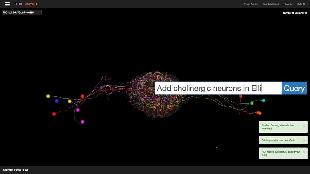
6
7 NeuroGFX: A Graphic Functional Explorer for the Fruit Fly Brain NeuroGFX is a programming interface that automatically translates biological and modeling data into executable code that can be run on a local or cloud-based GPU servers. It provides an intuitive graphical interface to leverage the power of the FFBO computational infrastructure, visualizes execution results in the context of biological structure. NeuroGFX provides an environment where computational researchers can present configurable, executable neural circuits, and experimental scientists can easily explore circuit structure and function ultimately leading to biological validation.
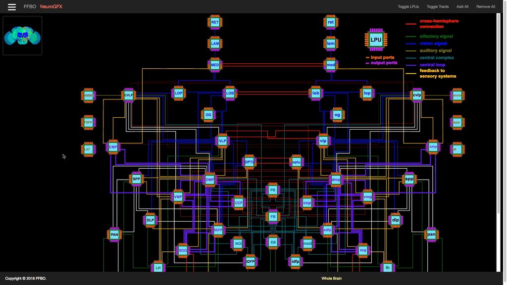
8

9 NeuroAPPs: Apps for Healthy and Diseased Models of the Fruit Fly Brain NeuroAPPs host integrated healthy and diseased models applications of the fruit fly brain. Early examples: Parkinson s Disease: Olfaction Epilepsy Model Parkinson s Disease: Vision Retinal Degeneration o an emulation of pathological states of the olfactory system due to excess release of the GABA neurotransmitter, a phenomenon observed in Parkinson s disease. o an interactive demonstration of the poorly-understood effect of the retinal degeneration seen in Parkinson's disease. o a model which can be used to reproduce experimental observations and to verify working hypotheses. o a retina app to study the potential of rescuing retinal degeneration by optogenetic means.
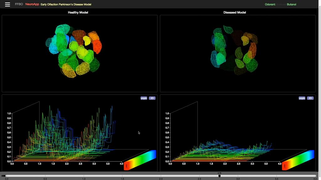
10
Data Aggregation with InfraWorks and ArcGIS for Visualization, Analysis, and Planning
 Data Aggregation with InfraWorks and ArcGIS for Visualization, Analysis, and Planning Stephen Brockwell President, Brockwell IT Consulting, Inc. Join the conversation #AU2017 KEYWORD Class Summary Silos
Introduction to Portal for ArcGIS. Hao LEE November 12, 2015
 Introduction to Portal for ArcGIS Hao LEE November 12, 2015 Agenda Web GIS pattern Product overview Installation and deployment Security and groups Configuration options Portal for ArcGIS + ArcGIS for
Introduction to Portal for ArcGIS
 Introduction to Portal for ArcGIS Derek Law Product Management March 10 th, 2015 Esri Developer Summit 2015 Agenda Web GIS pattern Product overview Installation and deployment Security and groups Configuration
Data Aggregation with InfraWorks and ArcGIS for Visualization, Analysis, and Planning
 CI125230 Data Aggregation with InfraWorks and ArcGIS for Visualization, Analysis, and Planning Stephen Brockwell Brockwell IT Consulting Inc. Sean Kinahan Brockwell IT Consulting Inc. Learning Objectives
MULTISCALE MODULARITY IN BRAIN SYSTEMS
 MULTISCALE MODULARITY IN BRAIN SYSTEMS Danielle S. Bassett University of California Santa Barbara Department of Physics The Brain: A Multiscale System Spatial Hierarchy: Temporal-Spatial Hierarchy: http://www.idac.tohoku.ac.jp/en/frontiers/column_070327/figi-i.gif
Portal for ArcGIS: An Introduction. Catherine Hynes and Derek Law
 Portal for ArcGIS: An Introduction Catherine Hynes and Derek Law Agenda Web GIS pattern Product overview Installation and deployment Configuration options Security options and groups Portal for ArcGIS
Computational Biology Course Descriptions 12-14
 Computational Biology Course Descriptions 12-14 Course Number and Title INTRODUCTORY COURSES BIO 311C: Introductory Biology I BIO 311D: Introductory Biology II BIO 325: Genetics CH 301: Principles of Chemistry
Leveraging Web GIS: An Introduction to the ArcGIS portal
 Leveraging Web GIS: An Introduction to the ArcGIS portal Derek Law Product Management DLaw@esri.com Agenda Web GIS pattern Product overview Installation and deployment Configuration options Security options
September 16, 2004 The NEURON Book: Chapter 2
 Chapter 2 The ing perspective This and the following chapter deal with concepts that are not NEURON-specific but instead pertain equally well to any tools used for neural ing. Why? In order to achieve
Portal for ArcGIS: An Introduction
 Portal for ArcGIS: An Introduction Derek Law Esri Product Management Esri UC 2014 Technical Workshop Agenda Web GIS pattern Product overview Installation and deployment Security and groups Configuration
Big Idea 1: The process of evolution drives the diversity and unity of life.
 Big Idea 1: The process of evolution drives the diversity and unity of life. understanding 1.A: Change in the genetic makeup of a population over time is evolution. 1.A.1: Natural selection is a major
AP Curriculum Framework with Learning Objectives
 Big Ideas Big Idea 1: The process of evolution drives the diversity and unity of life. AP Curriculum Framework with Learning Objectives Understanding 1.A: Change in the genetic makeup of a population over
Spatial Data Availability Energizes Florida s Citizens
 NASCIO 2016 Recognition Awards Nomination Spatial Data Availability Energizes Florida s Citizens State of Florida Agency for State Technology & Department of Environmental Protection Category: ICT Innovations
Integrating Globus into a Science Gateway for Cryo-EM
 Integrating Globus into a Science Gateway for Cryo-EM Michael Cianfrocco Life Sciences Institute Department of Biological Chemistry University of Michigan Globus World 2018 Impact & growth of Executive
Machine Learning to Automatically Detect Human Development from Satellite Imagery
 Technical Disclosure Commons Defensive Publications Series April 24, 2017 Machine Learning to Automatically Detect Human Development from Satellite Imagery Matthew Manolides Follow this and additional
A A A A B B1
 LEARNING OBJECTIVES FOR EACH BIG IDEA WITH ASSOCIATED SCIENCE PRACTICES AND ESSENTIAL KNOWLEDGE Learning Objectives will be the target for AP Biology exam questions Learning Objectives Sci Prac Es Knowl
Data Management Plan Extended Baryon Oscillation Spectroscopic Survey
 Data Management Plan Extended Baryon Oscillation Spectroscopic Survey Experiment description: eboss is the cosmological component of the fourth generation of the Sloan Digital Sky Survey (SDSS-IV) located
Enduring understanding 1.A: Change in the genetic makeup of a population over time is evolution.
 The AP Biology course is designed to enable you to develop advanced inquiry and reasoning skills, such as designing a plan for collecting data, analyzing data, applying mathematical routines, and connecting
Monitoring neurite morphology and synapse formation in primary neurons for neurotoxicity assessments and drug screening
 APPLICATION NOTE ArrayScan High Content Platform Monitoring neurite morphology and synapse formation in primary neurons for neurotoxicity assessments and drug screening Suk J. Hong and Richik N. Ghosh
COURSE CONTENT for Computer Science & Engineering [CSE]
![COURSE CONTENT for Computer Science & Engineering [CSE]](/thumbs/92/110586049.jpg "COURSE CONTENT for Computer Science & Engineering [CSE]") COURSE CONTENT for Computer Science & Engineering [CSE] 1st Semester 1 HU 101 English Language & Communication 2 1 0 3 3 2 PH 101 Engineering Physics 3 1 0 4 4 3 M 101 Mathematics 3 1 0 4 4 4 ME 101 Mechanical
COURSE CONTENT for Computer Science & Engineering [CSE] 1st Semester 1 HU 101 English Language & Communication 2 1 0 3 3 2 PH 101 Engineering Physics 3 1 0 4 4 3 M 101 Mathematics 3 1 0 4 4 4 ME 101 Mechanical
Spatial Analysis with Web GIS. Rachel Weeden
 Spatial Analysis with Web GIS Rachel Weeden Agenda Subhead goes here Introducing ArcGIS Online Spatial Analysis Workflows Scenarios Other Options Resources ArcGIS is a Platform Making mapping and analytics
Web GIS: Architectural Patterns and Practices. Shannon Kalisky Philip Heede
 Web GIS: Architectural Patterns and Practices Shannon Kalisky Philip Heede Web GIS Transformation of the ArcGIS Platform Desktop Apps Server GIS Web Maps Web Scenes Layers Web GIS Transformation of the
SPATIAL INFORMATION GRID AND ITS APPLICATION IN GEOLOGICAL SURVEY
 SPATIAL INFORMATION GRID AND ITS APPLICATION IN GEOLOGICAL SURVEY K. T. He a, b, Y. Tang a, W. X. Yu a a School of Electronic Science and Engineering, National University of Defense Technology, Changsha,
The iplant Collaborative Semantic Web Platform
 The iplant Collaborative Semantic Web Platform W O R K S H O P O N S E M A N T I C S I N G E O S PAT I A L A R C H I T E C T U R E S : A P P L I C AT I O N S A N D I M P L E M E N TAT I O N O c t o b e
Northrop Grumman Concept Paper
 Northrop Grumman Concept Paper A Comprehensive Geospatial Web-based Solution for NWS Impact-based Decision Support Services Glenn Higgins April 10, 2014 Northrop Grumman Corporation Information Systems
Research on the Architecture of Urban Emergency System Based on GIS Zhe Li1,a, Xiang Teng2,b
 3rd International Conference on Materials Engineering, Manufacturing Technology and Control (ICMEMTC 2016) Research on the Architecture of Urban Emergency System Based on GIS Zhe Li1,a, Xiang Teng2,b 1
ArcGIS. for Server. Understanding our World
 ArcGIS for Server Understanding our World ArcGIS for Server Create, Distribute, and Manage GIS Services You can use ArcGIS for Server to create services from your mapping and geographic information system
GENERALIZATION IN THE NEW GENERATION OF GIS. Dan Lee ESRI, Inc. 380 New York Street Redlands, CA USA Fax:
 GENERALIZATION IN THE NEW GENERATION OF GIS Dan Lee ESRI, Inc. 380 New York Street Redlands, CA 92373 USA dlee@esri.com Fax: 909-793-5953 Abstract In the research and development of automated map generalization,
Map of AP-Aligned Bio-Rad Kits with Learning Objectives
 Map of AP-Aligned Bio-Rad Kits with Learning Objectives Cover more than one AP Biology Big Idea with these AP-aligned Bio-Rad kits. Big Idea 1 Big Idea 2 Big Idea 3 Big Idea 4 ThINQ! pglo Transformation
AWOS. Automated Weather Observing Systems COASTAL
 AWOS Automated Weather Observing Systems COASTAL Environmental Systems Monitor Monitor Your Your World World Coastal s Experience & Expertise Since 1981, Coastal Environmental Systems, Inc. (Coastal) has
The Emerging Role of Enterprise GIS in State Forest Agencies
 The Emerging Role of Enterprise GIS in State Forest Agencies Geographic Information System (GIS) A geographic information system (GIS) is a computer software system designed to capture, store, manipulate,
Changes in Esri GIS, practical ways to be ready for the future
 Changes in Esri GIS, practical ways to be ready for the future John Sharrard, Esri April 16, 2015 The only thing that is constant is change. Heraclitus, ca. 500 B.C. My story (of experiencing change) Changes
Using Big Interagency Databases to Identify Climate Refugia for Idaho s Species of Concern
 Using Big Interagency Databases to Identify Climate Refugia for Idaho s Species of Concern What is a Climate Refugia? habitat that supports a locally reproducing population [or key life history stage]
Web GIS Administration: Tips and Tricks
 EdUC 2017 July 8 th, 2017 Web GIS Administration: Tips and Tricks Geri Miller Agenda Concerns Acknowledged User Management Content Management Monitoring Licensing and logins Sophistication of IT support
Crime Analysis. GIS Solutions for Intelligence-Led Policing
 Crime Analysis GIS Solutions for Intelligence-Led Policing Applying GIS Technology to Crime Analysis Know Your Community Analyze Your Crime Use Your Advantage GIS aids crime analysis by Identifying and
ArcGIS Earth for Enterprises DARRON PUSTAM ARCGIS EARTH CHRIS ANDREWS 3D
 ArcGIS Earth for Enterprises DARRON PUSTAM ARCGIS EARTH CHRIS ANDREWS 3D ArcGIS Earth is ArcGIS Earth is a lightweight globe desktop application that helps you explore any part of the world and investigate
ArcGIS Enterprise: What s New. Philip Heede Shannon Kalisky Melanie Summers Sam Williamson
 ArcGIS Enterprise: What s New Philip Heede Shannon Kalisky Melanie Summers Sam Williamson ArcGIS Enterprise is the new name for ArcGIS for Server What is ArcGIS Enterprise ArcGIS Enterprise is powerful
Environmental Chemistry through Intelligent Atmospheric Data Analysis (EnChIlADA): A Platform for Mining ATOFMS and Other Atmospheric Data
: A Platform for Mining ATOFMS and Other Atmospheric Data") Environmental Chemistry through Intelligent Atmospheric Data Analysis (EnChIlADA): A Platform for Mining ATOFMS and Other Atmospheric Data Katie Barton, John Choiniere, Melanie Yuen, and Deborah Gross
Environmental Chemistry through Intelligent Atmospheric Data Analysis (EnChIlADA): A Platform for Mining ATOFMS and Other Atmospheric Data Katie Barton, John Choiniere, Melanie Yuen, and Deborah Gross
Tools for Teaching Chemistry
 Tools for Teaching Chemistry Dan Damelin NEACT Summer Conference August 9, 2010 is a nonprofit educational research and development organization based in Concord, Massachusetts. creates interactive materials
Web GIS & ArcGIS Pro. Zena Pelletier Nick Popovich
 Web GIS & ArcGIS Pro Zena Pelletier Nick Popovich Web GIS Transformation of the ArcGIS Platform Desktop Apps GIS Web Maps Web Scenes Layers Evolution of the modern GIS Desktop GIS (standalone GIS) GIS
Supervisor: Prof. Stefano Spaccapietra Dr. Fabio Porto Student: Yuanjian Wang Zufferey. EPFL - Computer Science - LBD 1
 Supervisor: Prof. Stefano Spaccapietra Dr. Fabio Porto Student: Yuanjian Wang Zufferey EPFL - Computer Science - LBD 1 Introduction Related Work Proposed Solution Implementation Important Results Conclusion
Big Idea 3: Living systems store, retrieve, transmit, and respond to information essential to life processes.
 Big Idea 3: Living systems store, retrieve, transmit, and respond to information essential to life processes. Enduring understanding 3.A: Heritable information provides for continuity of life. Essential
OFWIM 2017 Annual Conference What Does Web GIS Really Mean for Fish and Wildlife Agencies?
 Content Open Mapping OFWIM 2017 Annual Conference What Does Web GIS Really Mean for Fish and Wildlife Agencies? Imagery Spatial Analysis Mike Bialousz, Esri 3D Data Exploration Real-Time Apps Visualization
Web Visualization of Geo-Spatial Data using SVG and VRML/X3D
 Web Visualization of Geo-Spatial Data using SVG and VRML/X3D Jianghui Ying Falls Church, VA 22043, USA jying@vt.edu Denis Gračanin Blacksburg, VA 24061, USA gracanin@vt.edu Chang-Tien Lu Falls Church,
Editorial Introduction: Special Issue on Grids and Geospatial Information Systems
 EditorialIntroduction:SpecialIssueonGridsand GeospatialInformationSystems MarlonE.Pierce CommunityGridsLaboratory IndianaUniversity mpierce@cs.indiana.edu Abstract: Grids and Geospatial Information Systems(GIS)
Enabling ENVI. ArcGIS for Server
 Enabling ENVI throughh ArcGIS for Server 1 Imagery: A Unique and Valuable Source of Data Imagery is not just a base map, but a layer of rich information that can address problems faced by GIS users. >
ESASky, ESA s new open-science portal for ESA space astronomy missions
 ESASky, ESA s new open-science portal for ESA space astronomy missions Bruno Merín ESAC Science Data Centre European Space Agency bruno.merin@esa.int Visit to NAOC, Beijing, 19/05/2017 ESA UNCLASSIFIED
TRAITS to put you on the map
 TRAITS to put you on the map Know what s where See the big picture Connect the dots Get it right Use where to say WOW Look around Spread the word Make it yours Finding your way Location is associated with
Counter-trafficking Integrated Display System (CIDS): A GIS-Based Command & Control Environment for Coalition Nations
: A GIS-Based Command & Control Environment for Coalition Nations") 9 th International Command and Control Research and Technology Symposium Counter-trafficking Integrated Display System (CIDS): A GIS-Based Command & Control Environment for Coalition Nations Elizabeth
9 th International Command and Control Research and Technology Symposium Counter-trafficking Integrated Display System (CIDS): A GIS-Based Command & Control Environment for Coalition Nations Elizabeth
USING BLAST TO IDENTIFY PROTEINS THAT ARE EVOLUTIONARILY RELATED ACROSS SPECIES
 USING BLAST TO IDENTIFY PROTEINS THAT ARE EVOLUTIONARILY RELATED ACROSS SPECIES HOW CAN BIOINFORMATICS BE USED AS A TOOL TO DETERMINE EVOLUTIONARY RELATIONSHPS AND TO BETTER UNDERSTAND PROTEIN HERITAGE?
From Research Objects to Research Networks: Combining Spatial and Semantic Search
 From Research Objects to Research Networks: Combining Spatial and Semantic Search Sara Lafia 1 and Lisa Staehli 2 1 Department of Geography, UCSB, Santa Barbara, CA, USA 2 Institute of Cartography and
CISC 3250 Systems Neuroscience
 CISC 3250 Systems Neuroscience Systems Neuroscience How the nervous system performs computations How groups of neurons work together to achieve intelligence Professor Daniel Leeds dleeds@fordham.edu JMH
Product Guide. Thermo Scientific Cellomics HCS Solution
 Product Guide Thermo Scientific Cellomics HCS Solution Thermo Scientific Cellomics HCS Solution Your Complete HCS Solution The search for new therapies for human diseases is increasingly driven by the
Enriching the GIScience Research Agenda: Fusing Augmented Reality (AR) and Location Based Social Networks (LBSN)
 and Location Based Social Networks (LBSN)") Enriching the GIScience Research Agenda: Fusing Augmented Reality (AR) and Location Based Social Networks (LBSN) Chengbi Liu and Sven Fuhrmann Department of Geography and Geoinformation Science George
Enriching the GIScience Research Agenda: Fusing Augmented Reality (AR) and Location Based Social Networks (LBSN) Chengbi Liu and Sven Fuhrmann Department of Geography and Geoinformation Science George
ArcGIS Deployment Pattern. Azlina Mahad
 ArcGIS Deployment Pattern Azlina Mahad Agenda Deployment Options Cloud Portal ArcGIS Server Data Publication Mobile System Management Desktop Web Device ArcGIS An Integrated Web GIS Platform Portal Providing
Features and Benefits
 Autodesk LandXplorer Features and Benefits Use the Autodesk LandXplorer software family to help improve decision making, lower costs, view and share changes, and avoid the expense of creating physical
Geography for the 2020 Round of Census
 Boundaries Key Census Data EA Id Population Male Female EA Id Area EA Id Num HH Avg HH size Geography for the 2020 Round of Census Linda Peters, Esri lpeters@esri.com Integration of Statistical and Geospatial
Magnetar Games Corporation
 'The higher we soar the smaller we appear to those who cannot fly.. Friedrich Nietzsche Magnetar Games Corporation Magnetar Multiverse Highlights! Standards based virtual alternate reality authoring and
Quantum computing with superconducting qubits Towards useful applications
 Quantum computing with superconducting qubits Towards useful applications Stefan Filipp IBM Research Zurich Switzerland Forum Teratec 2018 June 20, 2018 Palaiseau, France Why Quantum Computing? Why now?
Analytical data, the web, and standards for unified laboratory informatics databases
 Analytical data, the web, and standards for unified laboratory informatics databases Presented By Patrick D. Wheeler & Graham A. McGibbon ACS San Diego 16 March, 2016 Sources Process, Analyze Interfaces,
Estonian Place Names in the National Information System and the Place Names Register *
 UNITED NATIONS Working Paper GROUP OF EXPERTS ON No. 62 GEOGRAPHICAL NAMES Twenty-fifth session Nairobi, 5 12 May 2009 Item 10 of the provisional agenda Activities relating to the Working Group on Toponymic
E x a m p l e s o f t o o l s f o r s e a s i t u a t i o n a l a w a r e n e s s u s i n g C M E M S d a t a. Copernicus EU
 E x a m p l e s o f t o o l s f o r s e a s i t u a t i o n a l a w a r e n e s s u s i n g C M E M S d a t a Copernicus EU Copernicus EU Copernicus EU www.copernicus.eu S e a S i t u a t i o n a l A w
Sub-Riemannian geometry in models of the visual cortex
 Sub-Riemannian geometry in models of the visual cortex Scott Pauls Department of Mathematics Dartmouth College 4 th Symposium on Analysis and PDE Purdue, May 27, 2009 Mathematical structure in the visual
Millifluidic culture improves human midbrain organoid vitality and differentiation
 Millifluidic culture improves human midbrain organoid vitality and differentiation Emanuel Berger University of Luxembourg 3D midbrain organoids for modelling Parkinson s disease Healthy control Midbrain
Web GIS Deployment for Administrators. Vanessa Ramirez Solution Engineer, Natural Resources, Esri
 Web GIS Deployment for Administrators Vanessa Ramirez Solution Engineer, Natural Resources, Esri Agenda Web GIS Concepts Web GIS Deployment Patterns Components of an On-Premises Web GIS Federation of Server
ArcGIS is Advancing. Both Contributing and Integrating many new Innovations. IoT. Smart Mapping. Smart Devices Advanced Analytics
 ArcGIS is Advancing IoT Smart Devices Advanced Analytics Smart Mapping Real-Time Faster Computing Web Services Crowdsourcing Sensor Networks Both Contributing and Integrating many new Innovations ArcGIS
Cyberinfrastructure and CyberGIS: Recent Advances and Key Themes
 Cyberinfrastructure and CyberGIS: Recent Advances and Key Themes Shaowen Wang CyberInfrastructure and Geospatial Information Laboratory (CIGI) Department of Geography Department of Computer Science National
Enterprise Integration of Autodesk MapGuide at the City of Vancouver
 11/30/2005-8:00 am - 9:30 am Room:Toucan 1 (Swan) Walt Disney World Swan and Dolphin Resort Orlando, Florida Enterprise Integration of Autodesk MapGuide at the City of Vancouver Jonathan Mark - City of
Highland Park Physics I Curriculum Semester I Weeks 1-4
 NAME OF UNIT: Kinematics Components Unit Name Introduction Short Descriptive Overview Concepts Weeks 1-4 Survival Physics Describing Motion Mathematical Model of Motion In Physics, students conduct field
A Reconfigurable Quantum Computer
 A Reconfigurable Quantum Computer David Moehring CEO, IonQ, Inc. College Park, MD Quantum Computing for Business 4-6 December 2017, Mountain View, CA IonQ Highlights Full Stack Quantum Computing Company
AS INTEGRATIVE PLATFORMS FOR CLIMATE CHANGE IMPACT AND ADAPTATION ANALYSIS
 10 PAPER GEOGRAPHIC INFORMATION SYSTEMS AS INTEGRATIVE PLATFORMS FOR CLIMATE CHANGE IMPACT AND ADAPTATION ANALYSIS ROBIN BING RONG 1 and ADAM FENECH 1 1 Adaptation and Impacts Research Division, Environment
PowerWeb:
 Course: Anatomy and Physiology Course Number: 200030 Title: Understanding Human Anatomy and Physiology, th edition Author: Mader Publisher: Glencoe/McGraw-Hill Copyright: 200 Online Resources used in Correlations
Launch of Data Collection or Production Centre for World Weather Information Service
 Launch of Data Collection or Production Centre for World Weather Information Service The Hong Kong Observatory (HKO) announces that the Data Collection or Production Centre (DCPC) for the World Weather
Overview. Everywhere. Over everything.
 Cadenza Desktop Cadenza Web Cadenza Mobile Cadenza Overview. Everywhere. Over everything. The ultimate GIS and reporting suite. Provide, analyze and report data efficiently. For desktop, web and mobile.
One platform for desktop, web and mobile
 One platform for desktop, web and mobile Search and filter Get access to all data thematically filter data in context factually and spatially as well as display it dynamically. Export a selection or send
Esri and GIS Education
 Esri and GIS Education Organizations Esri Users 1,200 National Government Agencies 11,500 States & Regional Agencies 30,800 Cities & Local Governments 32,000 Businesses 8,500 Utilities 12,600 NGOs 11,000
GLOBAL NEEDS TO BE ADDRESSED IN A STRATEGIC PLAN FOR SPACE WEATHER. Developing products and services in space weather: Space Weather Channel in China
 WORLD METEOROLOGICAL ORGANIZATION COMMISSION FOR BASIC SYSTEMS COMMISSION FOR AERONAUTICAL METEOROLOGY INTER-PROGRAMME COORDINATION TEAM ON SPACE WEATHER ICTSW-4/Doc. 10.2(2) (25.XI.2013) ITEM: 10.2 FOURTH
Training Course / Nucleonica Overview
 Nucleonica: Basic, Core and Advanced Applications Training course with Hands on exercises, To be held at the IRMM JRC Geel, Belgium Training Course / Nucleonica Overview Dr. Joseph Magill, Nucleonica GmbH,
Capturing Chemistry. What you see is what you get In the world of mechanism and chemical transformations
 Capturing Chemistry What you see is what you get In the world of mechanism and chemical transformations Dr. Stephan Schürer ead of Intl. Sci. Content Libraria, Inc. sschurer@libraria.com Distribution of
Lectures on Medical Biophysics Department of Biophysics, Medical Faculty, Masaryk University in Brno. Biocybernetics
 Lectures on Medical Biophysics Department of Biophysics, Medical Faculty, Masaryk University in Brno Norbert Wiener 26.11.1894-18.03.1964 Biocybernetics Lecture outline Cybernetics Cybernetic systems Feedback
Web-based Exploration of and Interaction with Large and Deeply Structured Semantic 3D City Models using HTML5 and WebGL
 Web-based Exploration of and Interaction with Large and Deeply Structured Semantic 3D City Models using HTML5 and WebGL KANISHK CHATURVEDI 1, ZHIHANG YAO 2 & THOMAS H. KOLBE 1 Abstract: The aim of the
BIOLOGY (BIO) Biology (BIO) 1
 Biology (BIO) 1") Biology (BIO) 1 BIOLOGY (BIO) BIO 101. Biology and the Human Condition. (4 h) Basic principles in biology, emphasizing recent advances in biology in the context of their ethical, social, political, and
Biology (BIO) 1 BIOLOGY (BIO) BIO 101. Biology and the Human Condition. (4 h) Basic principles in biology, emphasizing recent advances in biology in the context of their ethical, social, political, and
Computational Analysis of the Fungal and Metazoan Groups of Heat Shock Proteins
 Computational Analysis of the Fungal and Metazoan Groups of Heat Shock Proteins Introduction: Benjamin Cooper, The Pennsylvania State University Advisor: Dr. Hugh Nicolas, Biomedical Initiative, Carnegie
CHAPTER 22 GEOGRAPHIC INFORMATION SYSTEMS
 CHAPTER 22 GEOGRAPHIC INFORMATION SYSTEMS PURPOSE: This chapter establishes the administration and use of to improve the quality and accessibility of Department s spatial information and support graphical
European Commission STUDY ON INTERIM EVALUATION OF EUROPEAN MARINE OBSERVATION AND DATA NETWORK. Executive Summary
 European Commission STUDY ON INTERIM EVALUATION OF EUROPEAN MARINE OBSERVATION AND DATA NETWORK Executive Summary by NILOS Netherlands Institute for the Law of the Sea June 2011 Page ii Study on Interim
INTEL-ISEF 2018 WINNERS
 INTEL-ISEF 2018 WINNERS Full Title of Award Student Project 1 st Award in the Chemistry Category and a Special Award from Thermo Fisher Scientific Dominic Yap, Bryan Lim, and Shawn Lim (IP Year 6) Hwa
Steps towards the Open Worm project. Stephen D. Larson NeuroML 3 rd Annual Meeting London, 4/1/2011
 Steps towards the Open Worm project Stephen D. Larson http://openworm.googlecode.com NeuroML 3 rd Annual Meeting London, 4/1/2011 What neuroscience can learn from AI: embodiment What neuroscience can learn
DRUG DISCOVERY TODAY ELN ELN. Chemistry. Biology. Known ligands. DBs. Generate chemistry ideas. Check chemical feasibility In-house.
 DRUG DISCOVERY TODAY Known ligands Chemistry ELN DBs Knowledge survey Therapeutic target Generate chemistry ideas Check chemical feasibility In-house Analyze SAR Synthesize or buy Report Test Journals
(effective fall 2017)
") EE ELECTIVES (effective fall 2017) Professional and technical electives are an integral part of the EE major curriculum. They allow students course flexibility as well as the unique opportunity to tailor
EE ELECTIVES (effective fall 2017) Professional and technical electives are an integral part of the EE major curriculum. They allow students course flexibility as well as the unique opportunity to tailor
CARTOGRAPHY in a Web World
 CARTOGRAPHY in a Web World SENSE Research Cluster XIII meeting: Concepts and tools for spatial data visualization BAREND KÖBBEN kobben@itc.nl b.j.kobben@utwente.nl Agenda Short introduction to ITC and
12/07/2017. Flash Flood Warning Service, an advanced approach towards flood resilient cities Floodplain Management Association Conference, Newcastle
 12/07/2017 Worldwide problem: Flash Floods Flash Floods are a Global Problem Flash Flood Warning Service, an advanced approach towards flood resilient cities Floodplain Management Association Conference,
EE, EP, EE & Society ELECTIVES (effective prior to fall 2017)
") EE, EP, EE & Society ELECTIVES (effective prior to fall 2017) Professional and technical electives are an integral part of the ECE major curriculum. They allow students course flexibility as well as the
EE, EP, EE & Society ELECTIVES (effective prior to fall 2017) Professional and technical electives are an integral part of the ECE major curriculum. They allow students course flexibility as well as the
The next generation in weather radar software.
 The next generation in weather radar software. PUBLISHED BY Vaisala Oyj Phone (int.): +358 9 8949 1 P.O. Box 26 Fax: +358 9 8949 2227 FI-00421 Helsinki Finland Try IRIS Focus at iris.vaisala.com. Vaisala
Visualization and manipulation of Matched Molecular Series for decision support
 250 th ACS National Meeting, Boston 16 th Aug 2015 Visualization and manipulation of Matched Molecular Series for decision support Noel O Boyle and Roger Sayle NextMove Software Matched (Molecular) Pairs
Geometric Algorithms in GIS
 Geometric Algorithms in GIS GIS Visualization Software Dr. M. Gavrilova GIS Software for Visualization ArcView GEO/SQL Digital Atmosphere AutoDesk Visual_Data GeoMedia GeoExpress CAVE? Visualization in
Eligible Fields of Study
 Eligible Fields of Study NSF Graduate Research Fellowship CHEMISTRY Chemical Catalysis Chemical Measurement and Imaging Chemical Structure, Dynamics, and Mechanism Chemical Synthesis Chemical Theory, Models
Building a National Data Repository
 Building a National Data Repository Mladen Stojic, Vice President - Geospatial 1/30/2013 2012 Intergraph Corporation 1 Information has meaning and gives power only when shared and distributed. Information,
THE DESIGN AND IMPLEMENTATION OF A WEB SERVICES-BASED APPLICATION FRAMEWORK FOR SEA SURFACE TEMPERATURE INFORMATION
 THE DESIGN AND IMPLEMENTATION OF A WEB SERVICES-BASED APPLICATION FRAMEWORK FOR SEA SURFACE TEMPERATURE INFORMATION HE Ya-wen a,b,c, SU Fen-zhen a, DU Yun-yan a, Xiao Ru-lin a,c, Sun Xiaodan d a. Institute
Basics of GIS reviewed
 Basics of GIS reviewed Martin Breunig Karlsruhe Institute of Technology martin.breunig@kit.edu GEODETIC INSTITUTE, DEPARTMENT OF CIVIL ENGINEERING, GEO AND ENVIRONMENTAL SCIENCES, CHAIR IN GEOINFORMATICS
Chapter 1 Introduction
 Chapter 1 Introduction 1.1 Introduction to Chapter This chapter starts by describing the problems addressed by the project. The aims and objectives of the research are outlined and novel ideas discovered