Latitude, Longitude, and Time Zones
|
|
|
- Alan Logan
- 6 years ago
- Views:
Transcription
1 Latitude, Longitude, and Time Zones
2 Typical Graph This is an example of a typical graph. It is made up of points that are connected by a line.
3 Y axis Typical Graph (4,7) Each point has two values: An X value that runs along the horizontal X axis and... A Y value that runs along the vertical Y axis X axis Each point is expressed as an X value and a Y value with the X value written first. For example... and... 7,5)
4 Typical Graph (-X,+Y) Y (+X,+Y) X Graphs may be divided into quadrants with the X and Y values being either positive (+) or negative (-) depending on the quadrant in which they are located. (-X,-Y) (+X,-Y) Now let s apply the same principles to latitude and longitude.
5 90 N What is latitude? Latitude is a horizontal line along the x-axis of the globe called a parallel It is expressed in degrees. The north pole is 90 N The south pole is 90 S The equator is 0 latitude. 90 S 0 What is the maximum possible latitude on Earth? 90 is maximum. You could be at 90 N or 90 S but there is no greater latitude on Earth (or anywhere else)
6 What is longitude? Longitude is a vertical line running north and south along the y-axis Just like latitude, longitude is measured in degrees. Lines of longitude are called meridians The prime meridian is 0 And if you go half way around the world you will reach the 180 longitude line. Understand that there aren t two 180 lines. On this FLAT map it just looks that way. It s the SAME line.
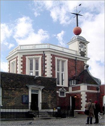
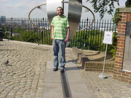
7 On the map horizontal lines are lines of latitude and... vertical lines are lines of longitude. The X axis is the equator Equator and the Y axis which runs through Greenwich, England is the Prime Meridian Prime Meridian

8 Any location north of the equator is a NORTH LATITUDE Where do most people on earth live?

9 Any location south of the equator is a SOUTH LATITUDE

10 Any location west of the prime meridian is a WEST LONGITUDE

11 Any location east of the prime meridian is an EAST LONGITUDE

12 We can divide the Earth into quadrants: NW where all latitudes are NORTH and all longitudes are WEST. Notice that EVERY point in the United States will have a NORTH latitude and a WEST longitude since we are in the NW quadrant.
?")

13 60 N, 30 W 75 S, 75 E 15 S, 105 W Each box on this map is 15. With that in mind how can we identify specific locations (red dots)? Remember, write latitude first! (It s the x coordinate) What are the coordinates of location...a What are the coordinates of location...b What are the coordinates of location...c But what about location D? It s in the middle of a box. What do we do now?
14 43 N Let s look at Ithaca, NY, the home of Cornell University. 77 W 76 W The latitude is more than 42 N but less than 43 N and the longitude is more than 76 W but less than 77 W Ithaca 42 N We need to be more precise. We can do that by subdividing each degree into 60 smaller units called minutes.
15 Degrees and Minutes Each DEGREE can be subdivided into 60 MINUTES This is true for BOTH longitude and latitude. 43 N 77 W 60 minutes 76 W 60 minutes 42 N
16 If there are 60 minutes in each degree then half a degree would be 30 minutes. Let s draw in the 30 minute (30 ) line. See these 2 marks? They are half way (30 ) between 42 N and 43 N. Using a ruler, connect them. The line you just drew is N. Now let s look at lines of longitude. See these 2 marks? They are half way (30 ) between 76 W and 77 W. Using a ruler, connect them. The line you just drew is W. Now let s see if we can locate Ithaca more precisely.


17 First comes latitude. Notice that Ithaca is just south of the N line. If it s not quite 30 then let s call it 25. Ithaca is located N. Now we ll do longitude which, for Ithaca is easy since it s located right on the W line. Ithaca s longitude is W. Now we ll put latitude and longitude together to give a precise location: Ithaca is N, W.
18 Here are some things to remember: > Latitude is written first and must always include N (north) or S (south) of the equator. > Longitude is written next and must always include E (east) or W (west) of the prime meridian. > Each degree of latitude or longitude can be divided into 60 minutes. > A minute, as used here, is a unit of distance on the earth s surface. It is not a unit of time. > Most of the time it will be impossible to be absolutely precise. Your best estimate might have to be to the nearest 5 or 10 minutes. In other words, an estimate of W is OK but W is trying to be more accurate than is reasonably possible.
19 Degrees and minutes Here is how you write degrees and minutes N (latitude) W (longitude) TOGETHER> N, W Latitude is always given first, followed by longitude. Typing tip: for the degree symbol, ALT-0176 (Try it!)
20 LONGITUDE AND LATITUDE LATITUDE PARALLEL EQUATOR LONGITUDE MERIDIAN DEGREES

21 PRIME MERIDIAN
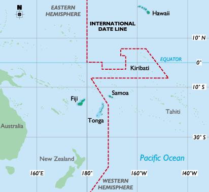
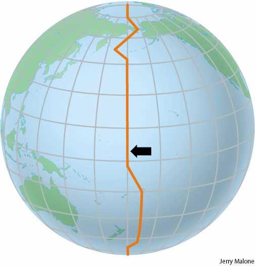
22 INTERNATIONAL DATE LINE Why the zigzag line?
23 TIME ZONES Time zones are measured by reference to a specific point, namely the prime meridian which runs through Greenwich, England. We have commonly referred to time at this point as Greenwich Mean Time -- GMT In recent years it has been common to refer to the more accurate Coordinated Universal Time (abbreviated as UTC) which uses an atomic time clock to regulate world time. UTC is used as a starting point to determine time in other countries worldwide. So, for example, if a country is stated as having the time UTC+3, this means that when it is 1:00 PM in Greenwich, it is 4pm in that country.

24 There are 24* primary world time zones Each time zone spans approximately 15 degrees of longitude * Because of local and political considerations there are actually more than 24 officially recognized time zones

25 WORLD CLOCK
26 UTC time?
27 JET LAG? Many travelers find that they suffer from a condition known as 'jet lag' when they have crossed time zones. This is a physiological condition triggered by the body becoming out of sync with the usual light and dark patterns to which it is accustomed. The condition is characterized by numerous symptoms, such as extreme fatigue, disorientation and loss of appetite. Jet lag often takes many days to recover; a rough medical guideline being one day per time zone. Sleep is seen as one of the best cures for jet lag, as is exposure to sunlight.

28 US TIME ZONES
29 FOUR US TIME ZONES

30 ABBREVIATIONS EST EDT CST MST PST AST HST

31 So what time is it right now in LONDON, England? PARIS, France? BOMBAY, India? CHICAGO? LOS ANGELOS? LAS VEGAS? See page 25 in your NWAt
Latitude and Longitude:
 Latitude and Longitude: Finding Locations on Planet Earth. With thanks and credit to Step.com Typical Graph This is an example of a typical graph. It is made up of points that are connected by a line.
Time Zones. Doug Fischer Geog 106 LRS
 Time Zones Doug Fischer Geog 106 LRS Learning goals Students should be able to Explain time zones as a function of longitude Calculate time differences between different locations Demonstrate corrections
Latitude and Longitude Pre Test
 Name Date Latitude and Longitude Pre Test Multiple Choice Directions: For questions, 1 10 circle the answer that letter that best answers the question. Each question is worth 1 point each. 1. To locate
Geographers Tools: Location Systems Prof. Anthony Grande Hunter College Geography
 5 Geographers Tools: Location Systems Prof. Anthony Grande Hunter College Geography Lecture design, content and presentation AFG 0119 Individual images and illustrations may be subject to prior copyright.
2. What does the map scale tell the map reader? a ratio between the actual distance on the ground and the length given to that distance on a map
 AP Human Geography - Damon Name Unit 1 - Intro to Human Geography Hour Map and Globe Skills Review Note: All links in this packet are found on our Wikispace under Map and Globe Skills Review First, read
LONGITUDE AND LATITUDE. Semi great circles joining the true or geographic poles of the earth (true meridians).
.") MERIDIANS OF LONGITUDE LONGITUDE AND LATITUDE Semi great circles joining the true or geographic poles of the earth (true meridians). They are measured from 0 to 180 degrees East and West of the PRIME MERIDIAN,
MERIDIANS OF LONGITUDE LONGITUDE AND LATITUDE Semi great circles joining the true or geographic poles of the earth (true meridians). They are measured from 0 to 180 degrees East and West of the PRIME MERIDIAN,
World Time-Day Calculator Lab
 Background: Time zones around the Earth are bounded by imaginary lines called lines of longitude, or meridians. On a globe or map of the world, they are the lines that are perpendicular to the equator.
Latitude and Longitude
 Latitude and Longitude Finding Your Location on a Sphere Coordinate Systems n When you are locating a point on a flat surface you can use Cartesian coordinates of x and y. n The point 2, 3 is plotted on
Cartesian Coordinates Need two dimensional system 2 number lines perpendicular to each other X-axis is horizontal Y-axis is vertical Position relative
 General Physical Science Chapter 15 Place and Time Space and Time Einstein Space and time related Single entity Time is the 4 th dimension! Cartesian Coordinates Need some system to tell us where something
Module 2: Mapping Topic 2 Content: Determining Latitude and Longitude Notes
 Introduction In order to more easily locate points on a globe or map, cartographers designed a system of imaginary vertical lines (also called parallels) and horizontal lines (also called meridians) that
Cardinal and Intermediate Directions:
 Name Period Parent Signature Due Date: (TBA) Geography/Map Skills Study Guide Continents and Oceans of the World: Label the continents (7) and oceans (4) on the lines below the map. 1 11 3 5 4 8 2 9 10
Earth s Time Zones. Time Zones In The United States
 Name: Mr. DeLeo Date: Period: Earth s Time Zones Goal: Students will understand why humans have developed time zones on Earth, and how to figure out time at different positions on Earth. Background: One
Map Skills Unit. Note taking unit
 Map Skills Unit Note taking unit Introduction To learn about the Earth, we are going to learn about two geographic tools you can use.globes and maps. Globe A globe is a round model of the planet Earth
Geographic Grid. Locations Feature 1 Feature 2 Feature 3
 Geographic Grid Name The geographic grid refers to the internationally-recognized system of latitude and longitude used to location positions on Earth's surface. Accurate use of this coordinate system
LAB C - GEOGRAPHIC GRID AND TIME
 Introduction LAB C - GEOGRAPHIC GRID AND TIME In this lab the student will learn to determine latitude and longitude, to plot the location of various places on a geographic grid, and to calculate the difference
 Name Period Parent Signature Geography/Map Skills Study Guide *For extra practice with these skills, check out Mr. Kath s website: http://rkath.weebly.com/activities--links.html Continents and Oceans of
Section 2. Locating Astronomical Objects in the Night Sky What Do You See? What Do You See? Think About It. Investigate.
 Section 2 Locating Astronomical Objects in the Night Sky Section 2 Locating Astronomical Objects in the Night Sky What Do You See? What Do You See? Learning Outcomes In this section, you will Construct
Introduction to Geography
 Introduction to Geography What is geography? Geography comes from the Greek word Geographia. Geo means earth and graphia means to describe or chart. Geographers study the earth in relation to space and
Use your text to define the following term. Use the terms to label the figure below. Define the following term.
 Mapping Our World Section. and Longitude Skim Section of your text. Write three questions that come to mind from reading the headings and the illustration captions.. Responses may include questions about
GEOGRAPHY. Map Skills. Mrs. Pere ~ 2013
 GEOGRAPHY Map Skills Mrs. Pere ~ 2013 WHAT IS A GLOBE? A globe is a model of the Earth. North Pole Equator South Pole WHAT IS A MAP? A map is a flat drawing of a place. THE IMPORTANT PARTS OF A MAP 1.
Aileen A. O Donoghue Priest Associate Professor of Physics
 SOAR: The Sky in Motion Life on the Tilted Teacup Ride Celestial Coordinates and the Day Aileen A. O Donoghue Priest Associate Professor of Physics Reference Points Poles Equator Prime Meridian Greenwich,
Mapping Earth s Surface Chapter 2 Section 3
 Mapping Earth s Surface Chapter 2 Section 3 Day 1 Objective I will understand maps can be used to find locations on Earth and to represent information about features on Earth s Surface I will understand
Aerial Photograhy. Brief history of aerial photography
 MAPWORK TOPIC ONE Why do we use maps? Maps are very important tools for geographers because they enable them to record, display and analyse information about people and the environment around them. Maps
2 Mapping Earth Reading Essentials. 2. Contrast What is the difference between a map view and a profile view?
 Mapping Earth Maps What do you think? Read the three statements below and decide whether you agree or disagree with them. Place an A in the Before column if you agree with the statement or a D if you disagree.
Geographic Grid -Latitudes and Longitudes
 GEOGRAPHY STD 9 Geographic Grid -Latitudes and Longitudes 2018-2019 Q1. Define Geographic Grid. The network of latitudes and longitudes are known as Geographic Grid. They help us to locate places on the
Cartography the art of making maps
 Cartography the art of making maps A map is a drawing or a picture of the earths surface, showing how things are related to each other by distance, direction and size. Maps are used for: Navigation Distance
Some of these parallels are very important. In the Northern Hemisphere, there is the Tropic of Cancer and the Arctic Circle.
 PDF 2 Geographic coordinates 1 The geographic coordinates system is network of imaginary horizontal and vertical lines that are drawn on globes or maps. These lines are called parallels (lines of latitude)
Grade 5 Lesson 3. Lesson Plan Page 2. Page 6. Student Activity Handout 1 Map Practice. Student Activity Handout 2 Marlins Park Maps.
 Grade 5 Lesson 3 Item Page Lesson Plan Page 2 Student Activity Handout 1 Map Practice Page 6 Student Activity Handout 2 Marlins Park Maps Page 10 DETERMINING METHODS VISION-SETTING Marlins Think Tank:
Unit 1: Geography and Social Studies Skills
 Unit 1: Geography and Social Studies Skills Standard(s) of Learning: WHI.1 The student will improve skills in historical research and geographical analysis by a) Identifying, analyzing, and interpreting
Downloaded from
 Geo Globe : Latitudes and Longitudes 1.Suppose the time at 30 east is 2 p.m. then what is the time at Greenwich? (A) 2 p.m. (B) 12 p.m. (C) 1 p.m. (D) Cannot find 2.What does the term 'Grid' mean
Geography 101: The Basics
 Geography 101: The Basics What is Geography? Geography is the study of the HUMAN and NON- HUMAN features of the Earth.! Geographers study where things are located why they are located in a specific place.!
The Earth and its representation
 GEOGRAPHY UNIT 1 The Earth and its representation THE SOLAR SYSTEM AND THE EARTH THE SOLAR SYSTEM The solar system is a planetary system. Is a group of astronomical objects who surround a star, in this
Why does Earth rotate and what s the evidence? (besides watching it from space ships or satellites) Week 18 January 5, 2015
 Week 18 January 5, 2015") Why does Earth rotate and what s the evidence? (besides watching it from space ships or satellites) Week 18 January 5, 2015 The sun determines our solar time everywhere on earth as Earth rotates. Can you
Why does Earth rotate and what s the evidence? (besides watching it from space ships or satellites) Week 18 January 5, 2015 The sun determines our solar time everywhere on earth as Earth rotates. Can you
Astronomy 101 Lab Manual. Victor Andersen Community College of Aurora
 Astronomy 101 Lab Manual Victor Andersen Community College of Aurora victor.andersen@ccaurora.edu January 8, 2013 2 Contents 1 Angular Measures 5 1.1 Introduction............................ 5 1.1.1 Degrees,
Lesson 20: The Earth in its Orbit
 291 Lesson 20: The Earth in its Orbit Recall that the Earth s orbit around the un is an ellipse which is almost a perfect circle. The average distance from the un to the Earth is 152,100,000 km (to the
TIME. Astronomical time Time is defined by astronomical cycles. The day is the average time from noon to noon (the solar day).
.") ASTRONOMY READER TIME 2.1 TIME Astronomical time Time is defined by astronomical cycles. The day is the average time from noon to noon (the solar day). The month was originally based on the average time
ASTRONOMY READER TIME 2.1 TIME Astronomical time Time is defined by astronomical cycles. The day is the average time from noon to noon (the solar day). The month was originally based on the average time
Latitudes and Longitudes
 Latitudes and Longitudes Angles are used to label latitudes and longitudes in order to locate points on our planet. It is a known fact that the earth is approximately a big sphere with a radius that is
CHAPTER 2 SKILL SHEET 2: CELESTIAL NAVIGATION
 CHAPTER 2 SKILL SHEET 2: CELESTIAL NAVIGATION Before the invention of GPS technology, how were people on ships far at sea, out of the sight of land, able to tell where they were? For thousands of years
Latitude and Longitude. Begin
 Latitude and Longitude Begin The Earth is divided in two halves, the top half is called the northern hemisphere, and the bottom half is called the southern hemisphere. The dividing line between the two
Background Information on Times Zones
 Background Information on Times Zones A day is the time it takes the Earth to spin around once on its axis. An hour is one twenty-fourth a day, so the Earth is divided into 24 standard time zones, each
THE EARTH AND ITS REPRESENTATION
 UNIT 7 THE EARTH AND ITS REPRESENTATION TABLE OF CONTENTS 1 THE EARTH AND THE SOLAR SYSTEM... 2 2 THE EARTH S MOVEMENTS... 2 2.1 Rotation.... 2 2.2 The revolution of the Earth: seasons of the year....
Spherical Geometry HSC. Name:
 Spherical Geometry HSC Name: C:\Documents and Settings\tracey_h-butters\Desktop\mathematics\year_levels\math_stage6\General\hsc\spherical_geometry\spherical_geo_notes.doc 1 HSC CAPACITY MATRIX GENERAL
Maps and Globes. By Kennedy s Korner
 Maps and Globes By Kennedy s Korner Map Key or Symbols Maps use symbols to show places and things on Earth. Symbols are drawings that stand for something real. A map key tells you what each symbol stands
Globes, Maps, and Atlases. Plus, A Whole Bunch of Other Way Cool Geographic Information!!!
 Globes, Maps, and Atlases Plus, A Whole Bunch of Other Way Cool Geographic Information!!! Globes Are the Most Accurate Portrayal of the Earth The earth is about 24,900 miles in circumference, and about
PHYSICAL GEOGRAPHY. By Brett Lucas
 PHYSICAL GEOGRAPHY By Brett Lucas INTRODUCTION Introduction to Earth Geography as a Field of Learning Geography is from two Greek words, Geo Earth, and Graphien to write. Elements/Branches of Geography
GLOBE : LATITUDES AND LONGITUDES
 2 Figure 2.1 : Globe Let s Do Take a big round potato or a ball. Pierce a knitting needle through it. The needle resembles the axis shown in a globe. You can now move the potato or the ball around this
Astrology Class Madison, Wisconsin. 43 North 89 West. September Daylight
 Astrology Class Madison, Wisconsin 43 North 89 West 7 32 September 21 2005 Daylight Astrology Class Madison, Wisconsin September 21,2005 7:32 43 North 89 West Names & Planetary Character Luminaries Symbols
Key Issue #1. How do geographers describe where things are? 2014 Pearson Education, Inc.
 Key Issue #1 How do geographers describe where things are? Learning Outcomes 1.1.1: Explain differences between early maps and contemporary maps. 1.1.2: Describe the role of map scale and projections and
Mapping Earth. How are Earth s surface features measured and modeled?
 Name Mapping Earth How are Earth s surface features measured and modeled? Before You Read Before you read the chapter, think about what you know about maps Record your thoughts in the first column Pair
Stamp Area. Earth Science - Note Packet #7. The shape of the Earth. The Earth is shaped like a ball or a. To go completely around the Earth,.
 Name: Earth Science - Note Packet #7 Mr. LaFranca s - Period Aim: What are time zones and why are they important? Date: Stamp Area Do Now: Why do you think East Coast football games start at 1:00 and West
Background Information
 Oceanography LAB #1: Marine Charts and Navigation Background Information Latitude and Longitude A coordinate is an address a means of designating location. Most coordinate systems involve a network of
1. Define map: 2. Name and define the five concepts that guide geographers a) 3. Define cartography: MAPS 4. A map serves two purposes a)
 3. Define cartography: MAPS 4. A map serves two purposes a)") 1. Define map: 2. Name and define the five concepts that guide geographers c) d) e) 3. Define cartography: MAPS 4. A map serves two purposes 5. Give two examples of early mapmaking and its (unusual?) materials
1. Define map: 2. Name and define the five concepts that guide geographers c) d) e) 3. Define cartography: MAPS 4. A map serves two purposes 5. Give two examples of early mapmaking and its (unusual?) materials
Sunlight and its Properties II. EE 446/646 Y. Baghzouz
 Sunlight and its Properties II EE 446/646 Y. Baghzouz Solar Time (ST) and Civil (clock) Time (CT) There are two adjustments that need to be made in order to convert ST to CT: The first is the Longitude
Latitude and Longitude, Plus Map Scale
 Name Lab 4 More Date: Latitude and Longitude, Plus Map Scale In the first few labs of the semester, you found that you needed to look at a variety of maps to answer all the questions. One reason you needed
Complete the following: a. Lines of latitude are parallel to the equator. Name:
 Name: Date: Social Studies Introduction: Basic Geography Period: Latitude Latitude is defined as a measurement of distance in degrees north and south of the equator. The word latitude is derived from the
Introduction to Geography
 Introduction to Geography ropic of Cancer 3½ N Arctic Circle 90 N Prime Meridian 0 Arctic Ocean Mississippi R. Appalachian Mts. Europe Rocky Mountains N. America Atlantic Gulf of Ocean Mexico Caribbean
 Name Period Parent Signature Foundational Skills Study Guide *For extra practice with these skills, check out Mr. Kath s website: http://rkath.weebly.com/activities--links.html Continents and Oceans of
page - 1 Laboratory Exercise #1 - Introduction to Latitude and Longitude Northern Hemisphere Southern Hemisphere
 page - 1 Laboratory Exercise #1 - Introduction to Latitude and Longitude A. Introduction There are many methods that can be used to locate ones position on the surface of the earth. A common method for
HOW TO TRAVEL ON EARTH WITHOUT GETTING LOST
 HOW TO TRAVEL ON EARTH WITHOUT GETTING LOST Using a globe to learn how a position on Earth can be described. Rui Dilão, Instituto Superior Técnico Curriculum topic latitude, longitude, coordinate system
Plane coordinates ~~~~~~~~~~
 Coordinate Systems & Map Projections Geographic coordinates A Basic Introduction to Coordinate Systems & Map Projections Latitude & longitude Angles Parallels & meridians Lines Plane coordinates ~~~~~~~~~~
Social Studies Tools (Maps & Sources) Test Study Guide
 Test Study Guide") Social Studies Tools (Maps & Sources) Test Study Guide Name: ANSWER KEY Date: Period: Directions: Complete this study guide as a way to prepare for your test on our Social Studies Tools unit about maps
Social Studies Tools (Maps & Sources) Test Study Guide Name: ANSWER KEY Date: Period: Directions: Complete this study guide as a way to prepare for your test on our Social Studies Tools unit about maps
Map Skills Lesson 1. Materials: maps, pencils, Lesson 1 Worksheet, strips of paper, grid paper
 Map Skills Lesson 1 Use cardinal directions, map grids, scales, and titles to locate places on a map. Interpret a map using information from its title, compass rose, scale, and legend. Vocabulary: map,
Earth Science Announcements
 Daily Routine Sit in your appropriate seat quietly Have all necessary materials out All back packs on the floor All cell phones on silent and away in backpacks All music devices off and headphones out
What is a map? A Map is a two or three-dimensional model or representation of the Earth s surface. 2-Dimensional map
 What is a map? A Map is a two or three-dimensional model or representation of the Earth s surface. 2-Dimensional map What is a Map Projection? Planar Projection Projection A Projection is a mathematical
1. Write down the term 2. Write down the book definition 3. Put the definition in your own words 4. Draw an image and/or put a Real Life Example
 Unit 1 Vocabulary 1. Write down the term 2. Write down the book definition 3. Put the definition in your own words 4. Draw an image and/or put a Real Life Example Absolute Location Where Is It EXACTLY?
Recall: The scale transformation
 Recall: The scale transformation Geography 12: Maps and Spatial Reasoning Lecture 3: Map Projection Basics Professor Keith Clarke 1:400M The real world A representation of the world A cartographic problem
1. Geospatial technology rarely links geospatial data to nonspatial data. a. True *b. False
 Chapter 2 Where in the Geospatial World Are You? 1. Geospatial technology rarely links geospatial data to nonspatial data. 2. For geospatial technology to work, every location on Earth must be: a. inhabited
Relative and Absolute Directions
 Relative and Absolute Directions Purpose Learning about latitude and longitude Developing math skills Overview Students begin by asking the simple question: Where Am I? Then they learn about the magnetic
The Coordinate System
 5 The Coordinate System Key Words: latitude, degrees, longitude, prime meridian, absolute location You can locate any place on Earth by using a special set of numbers. These numbers are part of a set of
The Earth-Moon-Sun System
 chapter 7 The Earth-Moon-Sun System section 2 Time and Seasons What You ll Learn how to calculate time and date in different time zones how to distinguish rotation and revolution what causes seasons Before
Spatial locations. Spatial locations. Spatial locations. Spatial locations
 Where am I? sounds simple, but definitely not huge amount of picky detail Cartographers make a career from the details focus on the minimum you need to know c Philip M. Dixon (Iowa State Univ.) Spatial
Chapter 3 Models of the Earth. 3.1 Finding Locations on the Earth. 3.1 Objectives
 Chapter 3 Models of the Earth 3.1 Finding Locations on the Earth 3.1 Objectives Explain latitude and longitude. How can latitude and longitude be used to find locations on Earth? How can a magnetic compass
The Earth is a Rotating Sphere
 The Earth is a Rotating Sphere The Shape of the Earth Earth s Rotation ( and relative movement of the Sun and Moon) The Geographic Grid Map Projections Global Time The Earth s Revolution around the Sun
Meridian Circle through Zenith, North Celestial Pole, Zenith Direction Straight Up from Observer. South Celestial Pole
 Chapter 3 How Earth and Sky Work- Effects of Latitude In chapters 3 and 4we will learn why our view of the heavens depends on our position on the Earth, the time of day, and the day of the year. We will
GEOL 309 Laboratory Activity: Euler Poles. Name
 GEOL 309 Laboratory Activity: Euler Poles Name Instructions: Follow the directions given. Take a picture (with your phone) of your work showing final pole locations on the globe. Print pictures and turn
APPENDIX A GLOSSARY. Appendix A.1
 APPENDIX A GLOSSARY Appendix A.1 Appendix A.2 Back Bearing A back bearing is measured from the object to your position. It is the exact opposite of a direct bearing. Base Line An imaginary line on the
2. GETTING STARTED WITH GIS
 2. GETTING STARTED WITH GIS What are geographic information systems and what are they used for? ArcGIS: ArcMap, ArcCatalog and ArcToolbox Vector data vs. raster data vs. attribute tables Polygons, polylines,
Key Issue 1: How Do Geographers Describe Where Things Are?
 Key Issue 1: How Do Geographers Describe Where Things Are? Pages 5-13 and some information from pages 15-18. ***Always keep your key term packet out whenever you take notes from Rubenstein. As the terms
GRADE 6 GEOGRAPHY TERM 1 LATITUDE AND LONGITUDE (degrees)
") 1 GRADE 6 GEOGRAPHY TERM 1 LATITUDE AND LONGITUDE (degrees) Contents Lines of Latitude... 2 Lines of Longitude... 3 The hemispheres of The Earth... 4 Finding countries and cities on a map using latitude
1 GRADE 6 GEOGRAPHY TERM 1 LATITUDE AND LONGITUDE (degrees) Contents Lines of Latitude... 2 Lines of Longitude... 3 The hemispheres of The Earth... 4 Finding countries and cities on a map using latitude
Stamp Area. Earth Science - Note Packet #6. The shape of the Earth. The Earth is in shape.
 Name: Earth Science - Note Packet #6 Mr. LaFranca s - Period Date: Aim: What are Latitude and Longitude? Do Now: Using the map, where is this location? Stamp Area X The shape of the Earth The Earth is
Indoor Lab #2: The Starry Sky
 17 Indoor Lab #2: The Starry Sky Objectives: To tour the sky and explore the way in which it moves, using the sky simulation program Starry Night Pro. Check out the information sheet on SN first, and try
GEOGRAPHY STD.9 LATITUDE & LONGITUDE
 GEOGRAPHY STD.9 LATITUDE & LONGITUDE 1. What is the Earth Grid? A. The complete network of meridians & parallels is called the earth Grid. 2. What is Latitude? A. The latitude of a place is the distance
FIND PLACES ON GLOBES USING LATITUDE
 GLOBES, MAPS & GRAPHS FIND PLACES ON GLOBES USING LATITUDE AND LONGITUDE LINES FIND PLACES ON MAPS USING A GRID SYSTEM NAME SEVERAL TYPES OF MAP PROJECTIONS AND EXPLAIN THEIR BENEFITS AND SHORTCOMINGS
Appearance of the Sky Orientation Motion of sky Seasons Precession (?)
") Today Appearance of the Sky Orientation Motion of sky Seasons Precession (?) The Celestial Sphere Stars at different distances all appear to lie on the celestial sphere. The ecliptic is the Sun s apparent
Today Appearance of the Sky Orientation Motion of sky Seasons Precession (?) The Celestial Sphere Stars at different distances all appear to lie on the celestial sphere. The ecliptic is the Sun s apparent
Geography involves the study of places: their locations, their characteristics, and how humans use and move around them.
 Physical Geography Looking at the Earth Geography involves the study of places: their locations, their characteristics, and how humans use and move around them. NEXT Physical Geography Looking at the Earth
Seasons & Time.
 Seasons & Time Earth s Movements Rotation Movement of Earth Around the Sun Elliptical Orbit Revolution 24 Hours (1 Day) 365 Days (1 Year) The Earth s Revolution & the Tilt of the axis cause variations
UNIT 1 THE BASICS OF GEOGRAPHY
 UNIT 1 THE BASICS OF GEOGRAPHY CHAPTER 1 LOOKING AT THE EARTH 1 Section 1.1: The 5 Themes of Geography.Geography comes from a Greek word meaning writing about or describing the earth. Geography is: Geographers
2017LearnedLessons. Mapping Skills
 Mapping Skills Geography Mapsà Flat representation of the earth Globeà round representation of the earth, truer representation Types of Maps & Uses General Purpose Mapsà show a wide range of information
Map Skills Test. 1. What do we call a person who makes maps? a. mapographer b. cartographer c. geologist d. archaeologist
 Map Skills Test 1. What do we call a person who makes maps? a. mapographer b. cartographer c. geologist d. archaeologist 2. What is the name of the 0 latitude line? a. Equator b. Arctic Circle c. First
Chapter 3 Geographic Location Systems
 Chapter 3 Geographic Location Systems In this chapter you will learn about: Latitude and longitude Universal Transverse Mercator (UTM) U.S. Public Land Survey Other geographic location systems Geographic
Chapter 2 - Lessons 1 & 2 Studying Geography, Economics
 Chapter 2 - Lessons 1 & 2 Studying Geography, Economics How does geography influence the way people live? Why do people trade? Why do people form governments? Lesson 1 - How Does Geography Influence the
Appearance of the Sky Orientation Motion of sky Seasons Precession (?)
") Today Appearance of the Sky Orientation Motion of sky Seasons Precession (?) The Celestial Sphere Stars at different distances all appear to lie on the celestial sphere. The ecliptic is the Sun s apparent
Today Appearance of the Sky Orientation Motion of sky Seasons Precession (?) The Celestial Sphere Stars at different distances all appear to lie on the celestial sphere. The ecliptic is the Sun s apparent
IR-4: Classroom Grid Region 4 Education Service Center Geography by Design, Volume 1
 IR-4: Classroom Grid 2013 Region 4 Education Service Center Geography by Design, Volume 1 IR-5: Latitude/Longitude Coordinates Location Latitude Longitude 35 N 139 E 11 N 104 E 1 N 103 E 18 N 72 E 59 N
Geography Can Be Cool. Seriously
 Geography Can Be Cool Seriously Why does geography matter? Geography: the study of looking at every aspect of the Earth s systems, such as human economies, societies, cultures, plants, animals, & climate.
Latitude & Longitude. Worksheets & activities to teach latitude & longitude. Includes notes, activities, review & all answer keys. 11 pages!
 Latitude & Longitude Worksheets & activities to teach latitude & longitude. Includes notes, activities, review & all answer keys. 11 pages! Lines of Latitude & Longitude Name: Lines of latitude and longitude
Chapter 1: The World of Geography
 Chapter 1: The World of Geography Chapter 1: What is Geography? *It is the study of our earth; our home. OR *Anything that can be mapped! *Geography mixes up the physical and human aspects of our world
Geographer s Toolkit. Geography of Canada
 Geographer s Toolkit Geography of Canada www.craigmarlatt.com/school Geographer s Toolkit 1. Parts of a Map Map Symbols Mapping Your Location 2. Types of Maps 3. Political Map of Canada 4. Drainage Map
Map Making. Chapter 2 Section 1
 Map Making Chapter 2 Section 1 Latitude and Longitude Objectives Compare and contrast latitude and longitude. Describe how time zones vary. Vocabulary cartography equator latitude longitude prime meridian
PROJECTIONS AND COORDINATES EXPLORED THROUGH GOOGLE EARTH EXERCISE (SOLUTION SHEET)
") PROJECTIONS AND COORDINATES EXPLORED THROUGH GOOGLE EARTH EXERCISE (SOLUTION SHEET) Name: Date: Period: Note: Correct answers on some problems are indicated with a yellow highlight. PROJECTIONS 1. Here
PROJECTIONS AND COORDINATES EXPLORED THROUGH GOOGLE EARTH EXERCISE (SOLUTION SHEET) Name: Date: Period: Note: Correct answers on some problems are indicated with a yellow highlight. PROJECTIONS 1. Here
Your web browser (Safari 7) is out of date. For more security, comfort and the best experience on this site: Update your browser Ignore
 is out of date. For more security, comfort and the best experience on this site: Update your browser Ignore") Your web browser (Safari 7) is out of date. For more security, comfort and the best experience on this site: Update your browser Ignore Activitydevelop Educator Version INTRO DUCTIO N TO L ATITU DE AND
Your web browser (Safari 7) is out of date. For more security, comfort and the best experience on this site: Update your browser Ignore Activitydevelop Educator Version INTRO DUCTIO N TO L ATITU DE AND